Arid Land Geography ›› 2026, Vol. 49 ›› Issue (9): 1940-1950.doi: 10.12118/j.issn.1000-6060.2025.643
• Regional Development • Previous Articles Next Articles
XU Qingdi( ), YANG Qing()
Received:2025-10-13
Revised:2025-11-25
Online:2026-09-25
Published:2026-09-07
Contact:
YANG Qing
E-mail:1073324020018@st.gsau.edu.cn;yangq@gsau.edu.cn
XU Qingdi, YANG Qing. Spatiotemporal coupling, evolutionary trajectories, and driving factors of grain production resilience and water resources carrying capacity in the Yellow River Basin[J].Arid Land Geography, 2026, 49(9): 1940-1950.
Fig. 1
Schematic diagram of the study area"
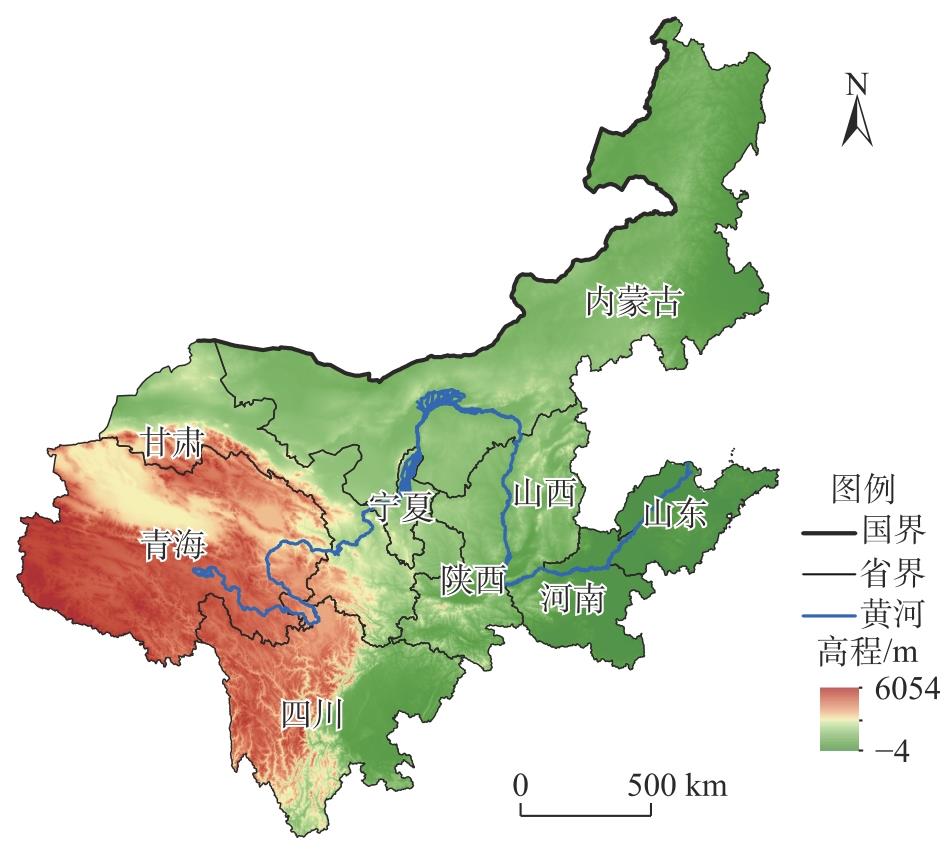
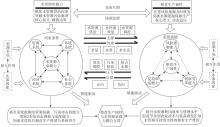
Fig. 2
Coupling coordination mechanism between grain production resilience and water resource carrying capacity"

Tab. 1
Indicator system for grain production resilience and water resource carrying capacity"
| 目标层 | 一级指标 | 二级指标 | 单位 | 指标计算方法 | 指标性质 |
|---|---|---|---|---|---|
| 水资源承 载力 | 资源环境 系统 | 人均水资源量(X1) | m3·人-1 | 区域水资源总量/区域人口总量 | + |
| 产水模数(X2) | m3·hm-2 | 区域水资源总量/区域总面积 | + | ||
| 水资源开发利用率(X3) | % | 区域供水总量/区域水资源总量 | - | ||
| 建成区绿化覆盖率(X4) | % | 统计数据 | + | ||
| 森林覆盖率(X5) | % | 统计数据 | + | ||
| 生态用水量(X6) | m3 | 统计数据 | + | ||
| 经济社会 系统 | 人均GDP(X7) | 元·人-1 | 地区生产总值/区域人口总量 | + | |
| 万元GDP用水量(X8) | m3·(104元)-1 | 年用水总量/地区生产总值 | - | ||
| 经济密度(X9) | 元·hm-2 | 地区生产总值/区域总面积 | + | ||
| 人口密度(X10) | 人·hm-2 | 区域人口总量/区域总面积 | - | ||
| 城镇化率(X11) | % | 区域城镇人口总量/区域人口总量 | + | ||
| 人均用水量(X12) | m3·人-1 | 统计数据 | - | ||
| 粮食生产 韧性 | 风险抵御 能力 | 耕地总面积(X13) | hm2 | 统计数据 | + |
| 有效灌溉面积(X14) | hm2 | 统计数据 | + | ||
| 农村第一产业从业人员数(X15) | 人 | 统计数据 | + | ||
| 粮食类居民消费价格指数(X16) | % | 当期粮食价格/基期粮食价格 | - | ||
| 单位面积粮食产量(X17) | kg·hm-2 | 粮食总产量/粮食播种面积 | + | ||
| 人均粮食占有量(X18) | kg·人-1 | 粮食总产量/全省总人数 | + | ||
| 复原调适 能力 | 复种指数(X19) | % | 农作物播种面积/耕地面积 | + | |
| 农业气象观测业务站点数(X20) | 个 | 统计数据 | + | ||
| 成灾率(X21) | % | 成灾面积/受灾面积×100 | - | ||
| 农村用电量(X22) | kWh | 统计数据 | + | ||
| 农药施用强度(X23) | kg·hm-2 | 农药施用量/农作物播种面积 | - | ||
| 化肥施用强度(X24) | kg·hm-2 | 化肥施用量/农作物播种面积 | - | ||
| 农膜施用强度(X25) | kg·hm-2 | 农膜使用量/农作物播种面积 | - | ||
| 创新变革 能力 | 机械化水平(X26) | kWh·hm-2 | 农业机械总动力/农作物播种面积 | + | |
| 单位播种面积农林牧渔服务业产值(X27) | 104元·hm-2 | 农林牧渔专业及辅助性活动产值/农作物播种面积 | + | ||
| 财政支农力度(X28) | % | 农林水事务支出/政府公共财政支出 | + | ||
| 农业科研人员数(X29) | 人 | 科研人员数×(农业总产值/生产总值) | + |
Tab. 2
Coupling coordination types and classification criteria"
| 类型 | 等级 | 耦合协调度 |
|---|---|---|
| 失调衰退型 | 极度失调 | 0.0~0.1 |
| 高度失调 | 0.1~0.2 | |
| 中度失调 | 0.2~0.3 | |
| 轻度失调 | 0.3~0.4 | |
| 濒临失调 | 0.4~0.5 | |
| 协调发展型 | 勉强协调 | 0.5~0.6 |
| 初级协调 | 0.6~0.7 | |
| 中级协调 | 0.7~0.8 | |
| 良好协调 | 0.8~0.9 | |
| 优质协调 | 0.9~1.0 |
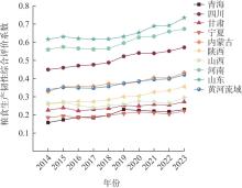
Fig. 3
Dynamic changes in the comprehensive evaluation coefficient of grain production resilience in the Yellow River Basin"
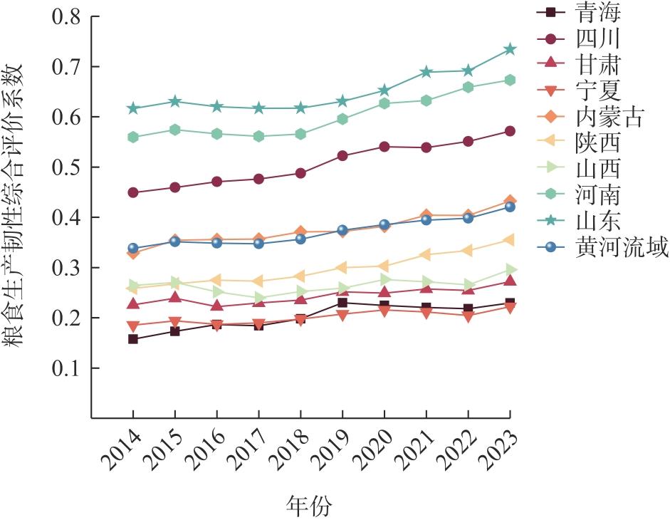
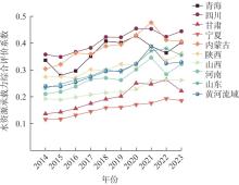
Fig. 4
Dynamic changes in the comprehensive evaluation coefficient of water resource carrying capacity in the Yellow River Basin"
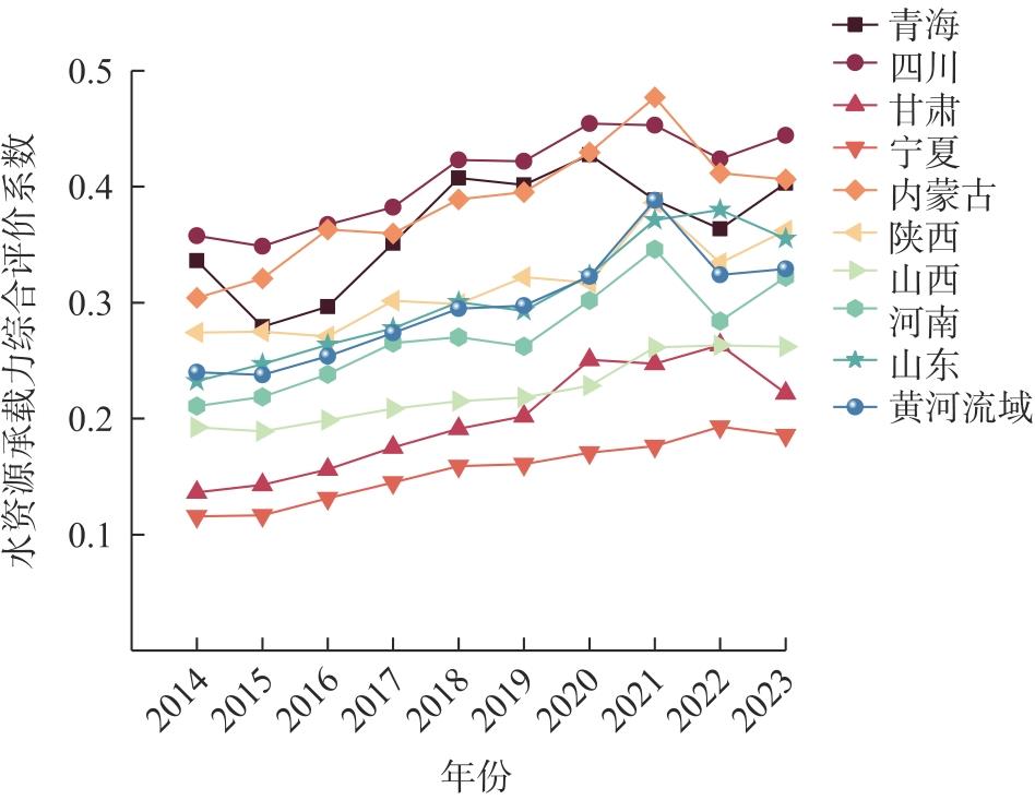
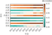
Fig. 5
Split heatmap of coupling coordination degree between two systems across the nine provinces and autonomous regions in the Yellow River Basin"
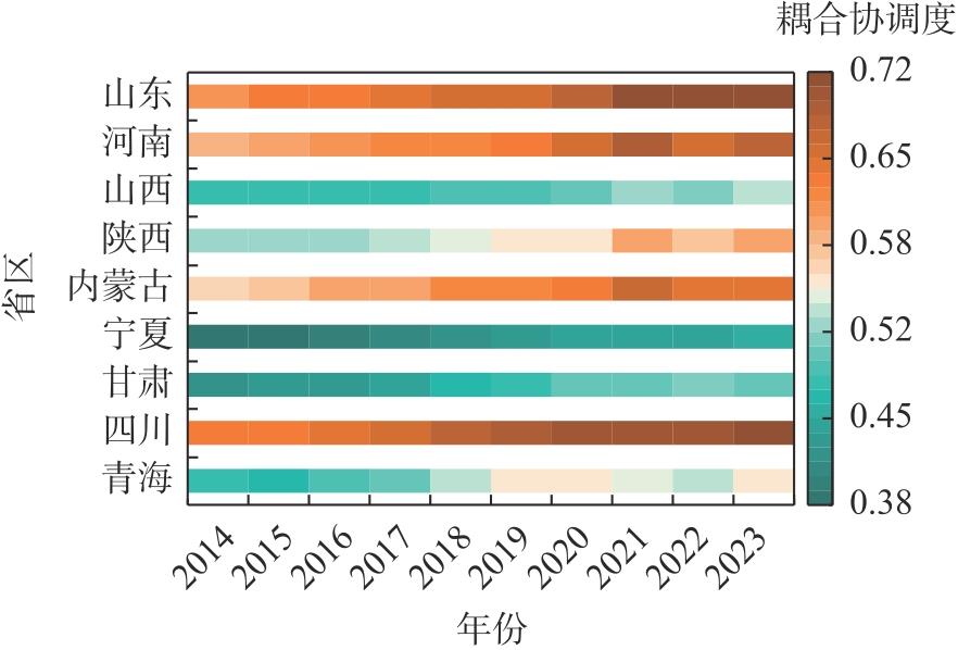
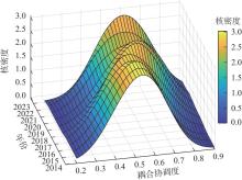
Fig. 6
Kernel density estimation of coupling coordination between two systems in the Yellow River Basin"
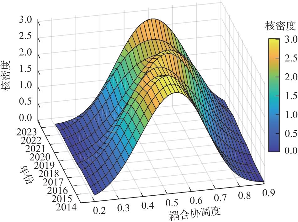
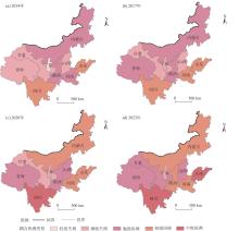
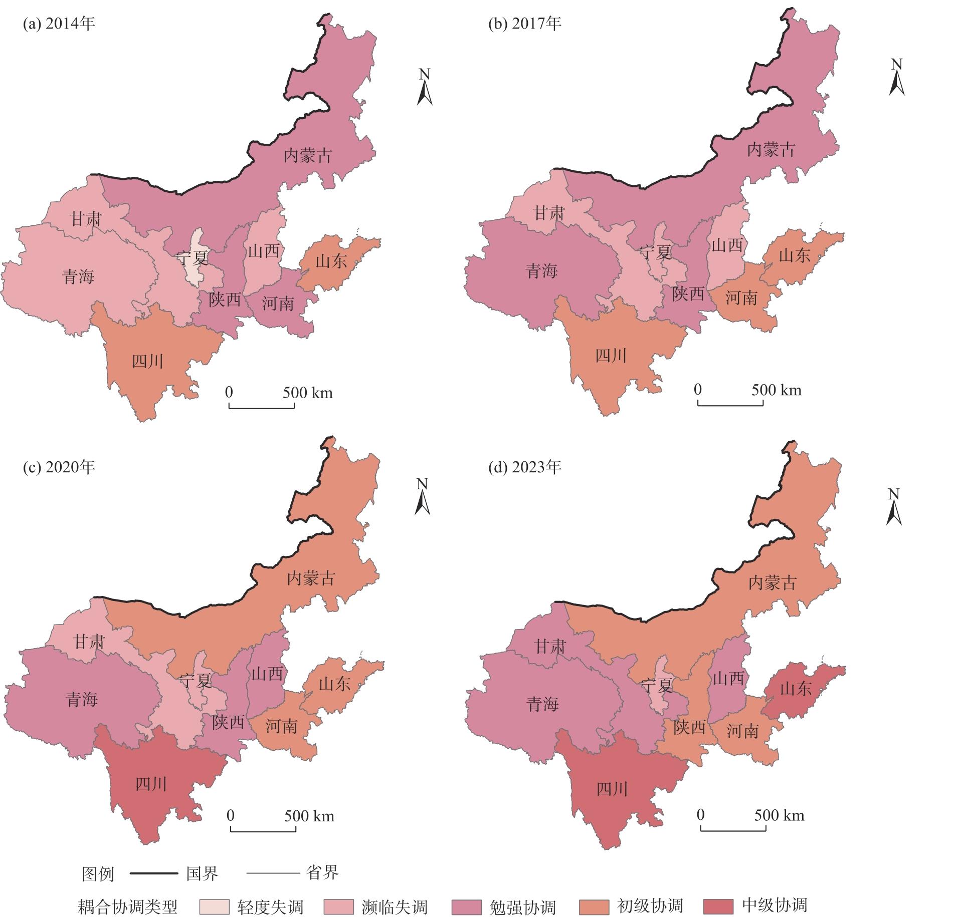
Fig. 7
Spatial evolution pattern of coupling coordination between two systems in the Yellow River Basin"
Tab. 3
Comparison of various algorithms"
| 模型类型 | 测试集R2 | RMSE | MAE | 交叉验证R2均值 | 交叉验证R2标准差 |
|---|---|---|---|---|---|
| 随机森林 | 0.9324 | 0.0228 | 0.0194 | 0.8934 | 0.0441 |
| SVR | 0.5672 | 0.0578 | 0.0500 | 0.4488 | 0.0732 |
| LightGBM | 0.8286 | 0.0364 | 0.0279 | 0.8163 | 0.0511 |
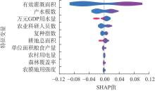
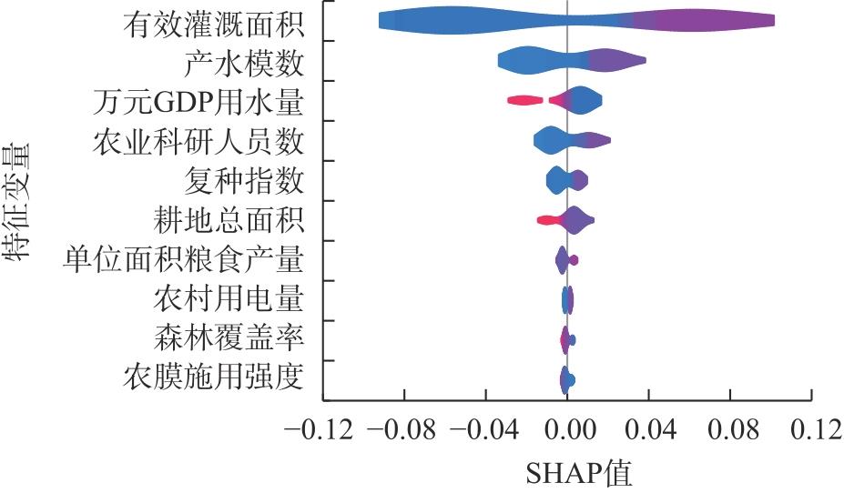
Fig. 8
SHAP feature analysis"
| [1] | 中共中央, 国务院. 加快建设农业强国规划(2024-2035年)[EB/OL]. [2025-04-07]. https://www.gov.cn/zhengce/202504/content_7017469.htm. |
| [Central Committee of the Communist Party of China, State Council. The plan for accelerating the building of a strong agricultural country(2024-2035)[EB/OL]. [2025-04-07]. https://www.gov.cn/zhengce/202504/content_7017469.htm.] | |
| [2] |
陆大道, 孙东琪. 黄河流域的综合治理与可持续发展[J]. 地理学报, 2019, 74(12): 2431-2436.
doi: 10.11821/dlxb201912001 |
|
[Lu Dadao, Sun Dongqi. Development and management tasks of the Yellow River Basin: A preliminary understanding and suggestion[J]. Acta Geographica Sinica, 2019, 74(12): 2431-2436.]
doi: 10.11821/dlxb201912001 |
|
| [3] | 康绍忠. 藏粮于水藏水于技——发展高水效农业保障国家食物安全[J]. 中国水利, 2022(13): 1-5. |
| [Kang Shaozhong. Storing grain in water and storing water in technology: Developing high water-efficiency agriculture to ensure national food security[J]. China Water Resources, 2022(13): 1-5.] | |
| [4] | 陈桂生, 彭俊杰. “水-能源-粮食”纽带视角下黄河流域数字经济的绿色作用机制研究[J]. 管理学刊, 2025, 38(1): 146-158. |
| [Chen Guisheng, Peng Junjie. Green effect of digital economy from a water-energy-food nexus perspective in China’s Yellow River Basin[J]. Journal of Management, 2025, 38(1): 146-158.] | |
| [5] | 谢群, 卢泽花, 贠晓哲. 黄河流域水资源承载力与高质量发展的耦合协调及其驱动机制研究[J]. 中国农业资源与区划, 2025, 46(4): 91-102. |
| [Xie Qun, Lu Zehua, Yun Xiaozhe. Research on coupling coordination and driving mechanism of water resource carrying capacity and high-quality development in the Yellow River Basin[J]. Chinese Journal of Agricultural Resources and Regional Planning, 2025, 46(4): 91-102.] | |
| [6] | 唐家凯, 丁文广, 李玮丽, 等. 黄河流域水资源承载力评价及障碍因素研究[J]. 人民黄河, 2021, 43(7): 73-77. |
| [Tang Jiakai, Ding Wenguang, Li Weili, et al. Study on evaluation of water resources carrying capacity and obstacle factors in the Yellow River Basin[J]. Yellow River, 2021, 43(7): 73-77.] | |
| [7] |
Yin Y Y, Tang Q H, Liu X C, et al. Water scarcity under various socio-economic pathways and its potential effects on food production in the Yellow River Basin[J]. Hydrology and Earth System Sciences, 2017, 21(2): 791-804.
doi: 10.5194/hess-21-791-2017 |
| [8] | 王帅, 甘林针, 钟钰. 走向韧性治理: 新时代国家粮食安全治理的思维转换与路径选择[J]. 华南农业大学学报(社会科学版), 2025, 24(3): 1-16. |
| [Wang Shuai, Gan Linzhen, Zhong Yu. Towards resilient governance: Thinking transformation and path selection of national food security governance in the new era[J]. Journal of South China Agricultural University (Social Science Edition), 2025, 24(3): 1-16.] | |
| [9] | Food and Agriculture Organization of the United Nations (FAO). The state of food and agriculture 2021: Making agrifood aystems more resilient to shocks and stresses[R]. Rome: Food and Agriculture Organization of the United Nations, 2021. |
| [10] | Béné C. Resilience of local food systems and links to food security: A review of some important concepts in the context of COVID-19 and other shocks[J]. Food Security, 2020(12): 805-822. |
| [11] | 程国强, 施嘉庚. 持续增强粮食安全保障能力: 党的十八大以来的政策逻辑与当前的着力点[J]. 南京农业大学学报(社会科学版), 2025, 25(4): 45-55. |
| [Cheng Guoqiang, Shi Jiageng. Continuous enhancement of food security capacity: The policy logics since the 18th national congress of the communist party of China and current focus[J]. Journal of Nanjing Agricultural University (Social Sciences Edition), 2025, 25(4): 45-55.] | |
| [12] | 陈有华, 卢欣雨, 张壮, 等. 农业生产社会-生态系统韧性:维度与度量[J]. 生态学报, 2025, 45(9): 4548-4560. |
| [Chen Youhua, Lu Xinyu, Zhang Zhuang, et al. Resilience of agricultural production systems: Dimensions and measurements[J]. Acta Ecologica Sinica, 2025, 45(9): 4548-4560.] | |
| [13] | 董亚妮, 祁春节, 桂成. 粮食产业链韧性测度、区域差异及收敛性研究——以长江经济带108个地级市为例[J]. 干旱区资源与环境, 2025, 39(8): 41-54. |
| [Dong Yani, Qi Chunjie, Gui Cheng. Resilience measurement, regional differences and convergence of food industry chain: Case study of 108 cities in the Yangtze River Economic Belt[J]. Journal of Arid Land Resources and Environment, 2025, 39(8): 41-54.] | |
| [14] | 李菲菲, 周霞, 周玉玺. 中国粮食生产韧性的时空特征及演化趋势研究[J]. 统计与决策, 2025, 41(4): 75-80. |
| [Li Feifei, Zhou Xia, Zhou Yuxi. Study on the spatiotemporal characteristics and evolution trend of China’s grain production resilience[J]. Statistics & Decision, 2025, 41(4): 75-80.] | |
| [15] | 张永旺, 周欣欣. 气候变化视角下中国粮食生产韧性时空差异及影响因素研究——以粮食主产区为例[J]. 农业经济与管理, 2024(6): 63-76. |
| [Zhang Yongwang, Zhou Xinxin. Spatial-temporal differences and influencing factors of grain production resilience in China from perspective of climate change: A case study of major grain producing areas[J]. Agricultural Economics and Management, 2024(6): 63-76.] | |
| [16] |
李云玲, 郭旭宁, 郭东阳, 等. 水资源承载能力评价方法研究及应用[J]. 地理科学进展, 2017, 36(3): 342-349.
doi: 10.18306/dlkxjz.2017.03.010 |
|
[Li Yunling, Guo Xuning, Guo Dongyang, et al. An evaluation method of water resources carrying capacity and application[J]. Progress in Geography, 2017, 36(3): 342-349.]
doi: 10.18306/dlkxjz.2017.03.010 |
|
| [17] |
Cheng K, Fu Q, Meng J, et al. Analysis of the spatial variation and identification of factors affecting the water resources carrying capacity based on the cloud model[J]. Water Resources Management, 2018, 32(8): 2767-2781.
doi: 10.1007/s11269-018-1957-x |
| [18] | 张泽琳, 周霞, 周玉玺. 黄河下游水资源承载力与粮食生产韧性时空耦合及驱动因素[J]. 水土保持研究, 2024, 31(3): 412-420, 431. |
| [Zhang Zelin, Zhou Xia, Zhou Yuxi. Spatiotemporal coupling and driving factors of water resources carrying capacity and grain production resilience in the lower reaches of the Yellow River[J]. Research of Soil and Water Conservation, 2024, 31(3): 412-420, 431.] | |
| [19] | 热孜娅·阿曼, 方创琳, 赵瑞东. 新疆水资源承载力评价与时空演变特征分析[J]. 长江流域资源与环境, 2020, 29(7): 1576-1585. |
| [Aman Reziya, Fang Chuanglin, Zhao Ruidong. Research on the water resources carrying capacity and spatial-temporal characteristics in Xinjiang[J]. Resources and Environment in the Yangtze Basin, 2020, 29(7): 1576-1585.] | |
| [20] | 罗强, 黄大金. 水资源安全与粮食生产韧性耦合协调特征及驱动因素研究——基于中国粮食主产区的实证[J]. 中国农机化学报, 2025, 46(7): 310-318. |
| [Luo Qiang, Huang Dajin. Coupling coordination and driving factors of water resources security and grain production resilience: An empirical analysis of China’s major grain-producing regions[J]. Journal of Chinese Agricultural Mechanization, 2025, 46(7): 310-318.] | |
| [21] | 陈振, 郑锐, 李佩华, 等. 河南省农业科技创新效率评价与分析[J]. 河南农业大学学报, 2018, 52(3): 464-469. |
| [Chen Zhen, Zheng Rui, Li Peihua, et al. Evaluation and analysis of agricultural science and technology innovation efficiency in Henan Province[J]. Journal of Henan Agricultural University, 2018, 52(3): 464-469.] | |
| [22] |
王淑佳, 孔伟, 任亮, 等. 国内耦合协调度模型的误区及修正[J]. 自然资源学报, 2021, 36(3): 793-810.
doi: 10.31497/zrzyxb.20210319 |
|
[Wang Shujia, Kong Wei, Ren Liang, et al. Research on misuses and modification of coupling coordination degree model in China[J]. Journal of Natural Resources, 2021, 36(3): 793-810.]
doi: 10.31497/zrzyxb.20210319 |
|
| [23] | 李珂, 何静, 孟阳阳, 等. 黄河流域乡村旅游重点村空间分布及影响因素[J]. 干旱区地理, 2025, 48(1): 2031-2041. |
| [Li Ke, He Jing, Meng Yangyang, et al. Spatial distribution and influencing factors of key rural tourism villages in the Yellow River Basin[J]. Arid Land Geography, 2025, 48(1): 2031-2041.] | |
| [24] |
Breiman L. Random forests[J]. Machine Learning, 2001, 45(1): 5-32.
doi: 10.1023/A:1010933404324 |
| [25] | 刘媛, 熊柴, 蔡继明. 农民工进城落户的意愿为什么不高?--基于可解释机器学习方法的分析[J]. 中国农村经济, 2025, 47(4): 20-41. |
| [Liu Yuan, Xiong Chai, Cai Jiming. Why are rural migrant workers not willing to transfer Hukou to cities? An analysis based on interpretable machine learning methods[J]. Chinese Rural Economy, 2025, 47(4): 20-41.] | |
| [26] | 陈展图, 杨庆媛, 童小容. 轮作休耕推进农业供给侧结构性改革路径研究[J]. 农村经济, 2017(7): 20-25. |
| [Chen Zhantu, Yang Qingyuan, Tong Xiaorong. Research on the path of structural reform of agricultural supply side by rotation and fallow[J]. Rural Economy, 2017(7): 20-25.] | |
| [27] | 中华人民共和国水利部. 中国水资源公报2022[R]. 北京: 中国水利水电出版社, 2023. |
| [Ministry of Water Resources of the People’s Republic of China. China water resources bulletin 2022[R]. Beijing: China Water & Power Press, 2023.] |
|
||

