Arid Land Geography ›› 2026, Vol. 49 ›› Issue (9): 1951-1964.doi: 10.12118/j.issn.1000-6060.2025.575
• Regional Development • Previous Articles Next Articles
JIANG Zhihui( ), JU Huiqi(), OUYANG Jinqiong, SU Xufeng
Received:2025-09-19
Revised:2025-11-20
Online:2026-09-25
Published:2026-09-07
Contact:
JIANG Zhihui
E-mail:jiangzhihui78@163.com;17857687116@163.com
JIANG Zhihui, JU Huiqi, OUYANG Jinqiong, SU Xufeng. Multiple paths for the governance of agricultural production water footprint in Xinjiang from the configurational perspective[J].Arid Land Geography, 2026, 49(9): 1951-1964.
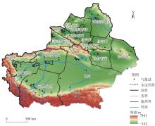
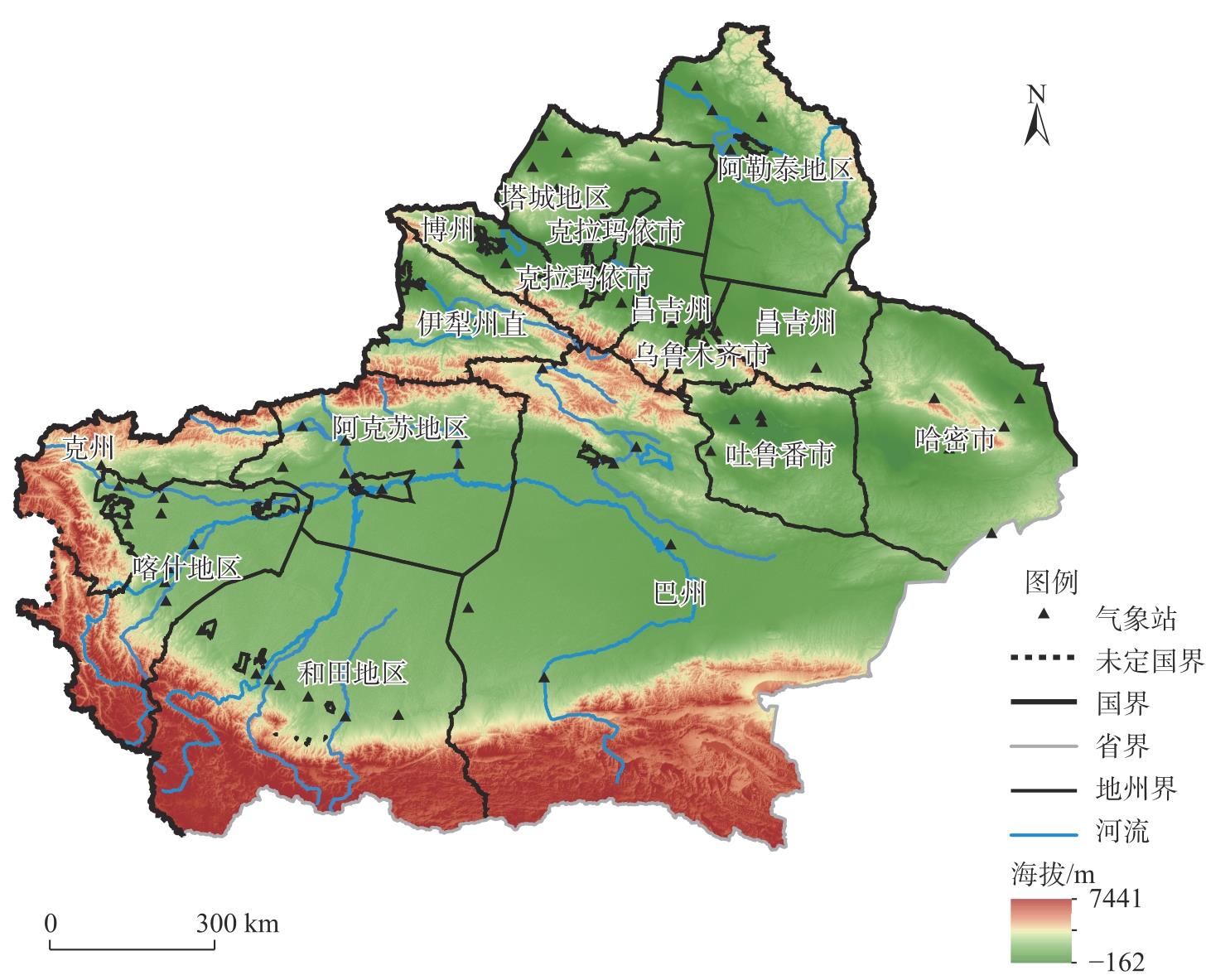
Fig. 1
Schematic diagram of the study area"

Tab. 1
Crop coefficients of different regions in Xinjiang"
| 作物 | 区域 | 开始生长 日期(月-日) | 结束生长 日期(月-日) | 平均作 物系数[ | 生育期 天数[ |
|---|---|---|---|---|---|
| 棉花 | 北疆 | 04-30 | 10-09 | 0.64 | 162 |
| 南疆 | 04-11 | 10-15 | 0.64 | 187 | |
| 东疆 | 04-10 | 10-07 | 0.64 | 180 | |
| 冬小麦 | 南疆 | 09-11 | 07-10 | 0.43 | 300 |
| 春小麦 | 北疆 | 04-01 | 07-21 | 0.53 | 111 |
| 小麦 | 东疆 | 04-01 | 07-21 | 0.53 | 111 |
| 玉米 | 全疆 | 04-21 | 09-11 | 0.57 | 143 |
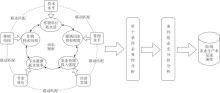
Fig. 2
Theoretical framework of various driving factors influencing the intensity of production water footprint from the configurational perspective"
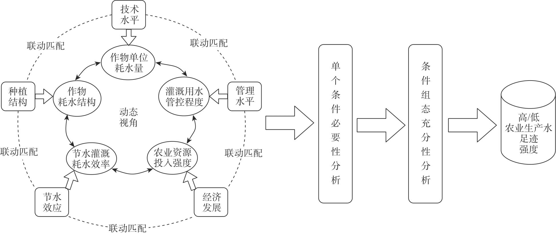
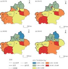
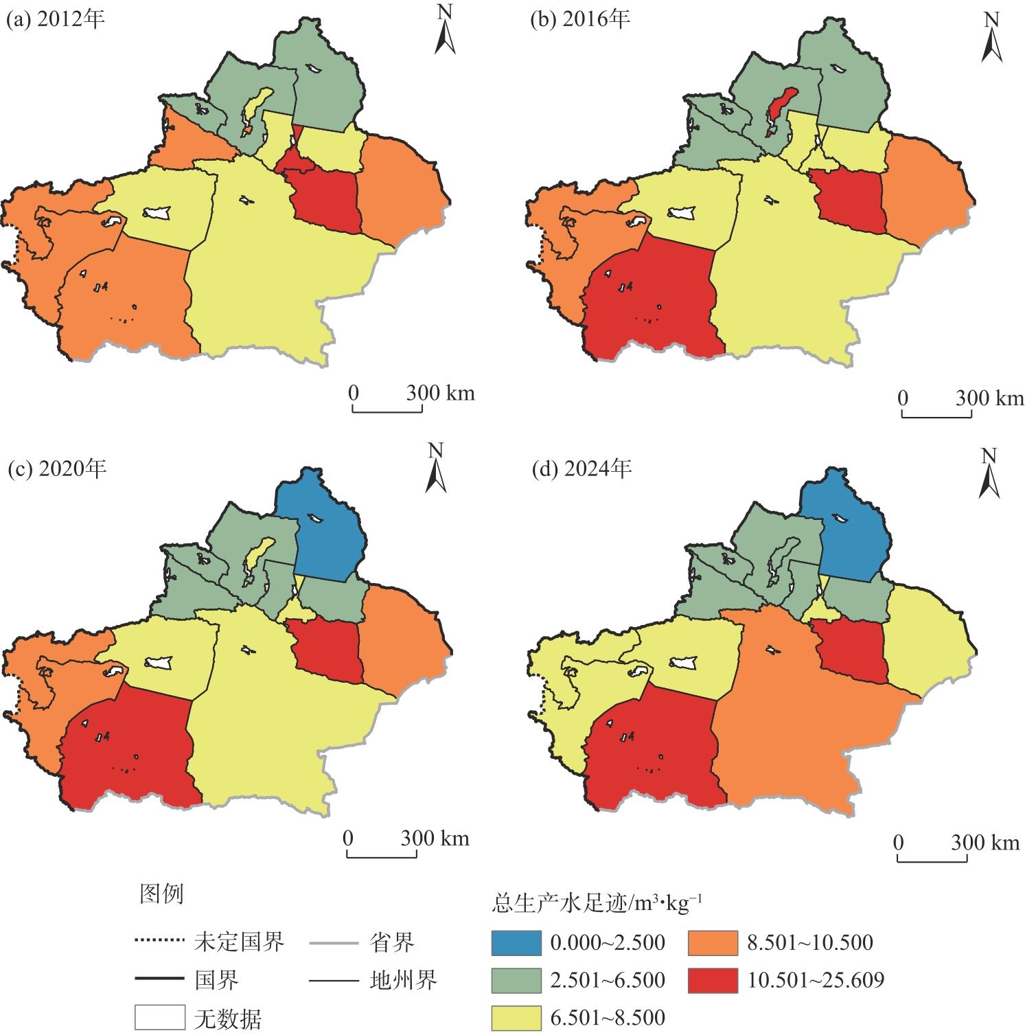
Fig. 3
Spatial distributions of crop total production water footprint in Xinjiang from 2012 to 2024"
Tab. 2
Decomposition of the effects of various driving factors on achieving low water footprint intensity in different periods"
| 因素 | 贡献度 | ||
|---|---|---|---|
| 2012—2015年 | 2016—2020年 | 2021—2024年 | |
| 技术进步效应 | -0.037 | 0.109 | -4.456 |
| 种植结构效应 | -0.023 | 0.051 | -0.267 |
| 节水效应 | 0.059 | -0.176 | 3.330 |
| 管理水平效应 | 0.021 | 0.104 | -1.001 |
| 农业经济发展水平 | 0.006 | -0.173 | 1.029 |
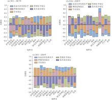
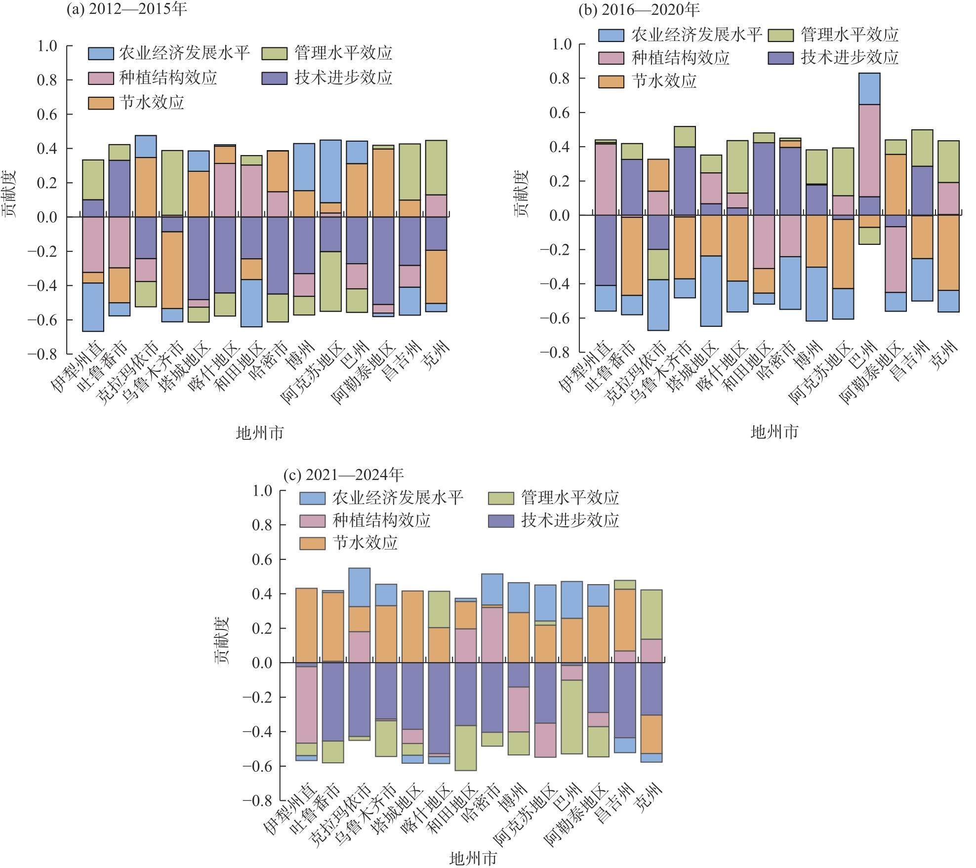
Fig. 4
Changes in contribution degree of various driving factors in different periods"
Tab. 3
Variable calibration and descriptive analysis"
| 变量名称 | 指标 | 校准 | 描述性分析 | |||||||
|---|---|---|---|---|---|---|---|---|---|---|
| 完全隶属 | 交叉点 | 完全不隶属 | 均值 | 标准差 | 最大值 | 最小值 | ||||
| 结果变量 | 生产水足迹强度 | Y | 0.022 | 0.057 | 0.483 | 0.225 | 0.405 | 2.485 | 0.015 | |
| 条件变量 | 技术水平 | X1 | -1.399 | -0.134 | 1.199 | -0.084 | 1.402 | 7.900 | -3.789 | |
| 种植结构 | X2 | -1.152 | -0.012 | 1.615 | 0.066 | 1.342 | 4.034 | -5.966 | ||
| 节水效应 | X3 | -1.663 | 0.062 | 1.376 | -0.066 | 1.465 | 3.945 | -5.532 | ||
| 管理水平 | X4 | -1.108 | 0.119 | 1.192 | 0.092 | 0.965 | 2.236 | -4.018 | ||
| 农业经济发展水平 | X5 | -1.279 | -0.262 | 0.878 | -0.333 | 1.311 | 1.937 | -12.414 | ||
Tab. 4
Necessity test of individual conditions in the dynamic qualitative comparative analysis (dynamic QCA) method"
| 前因条件 | 低生产水足迹强度 | 高生产水足迹强度 | |||||||
|---|---|---|---|---|---|---|---|---|---|
| 汇总一致性 | 汇总覆盖度 | 组间一致性 调整距离 | 组内一致性调整距离 | 汇总一致性 | 汇总覆盖度 | 组间一致性调整距离 | 组内一致性调整距离 | ||
| X1 | 0.615 | 0.654 | 0.265 | 0.244 | 0.604 | 0.572 | 0.397 | 0.307 | |
| ~X1 | 0.598 | 0.629 | 0.269 | 0.236 | 0.636 | 0.595 | 0.374 | 0.297 | |
| X2 | 0.626 | 0.672 | 0.327 | 0.253 | 0.589 | 0.564 | 0.296 | 0.297 | |
| ~X2 | 0.594 | 0.618 | 0.386 | 0.253 | 0.658 | 0.610 | 0.288 | 0.230 | |
| X3 | 0.586 | 0.612 | 0.389 | 0.265 | 0.665 | 0.618 | 0.257 | 0.283 | |
| ~X3 | 0.634 | 0.680 | 0.389 | 0.282 | 0.582 | 0.556 | 0.350 | 0.295 | |
| X4 | 0.617 | 0.676 | 0.222 | 0.277 | 0.590 | 0.577 | 0.249 | 0.303 | |
| ~X4 | 0.614 | 0.627 | 0.269 | 0.261 | 0.668 | 0.608 | 0.226 | 0.242 | |
| X5 | 0.599 | 0.630 | 0.405 | 0.207 | 0.627 | 0.588 | 0.483 | 0.299 | |
| ~X5 | 0.609 | 0.647 | 0.393 | 0.261 | 0.605 | 0.573 | 0.456 | 0.291 | |
Tab. 5
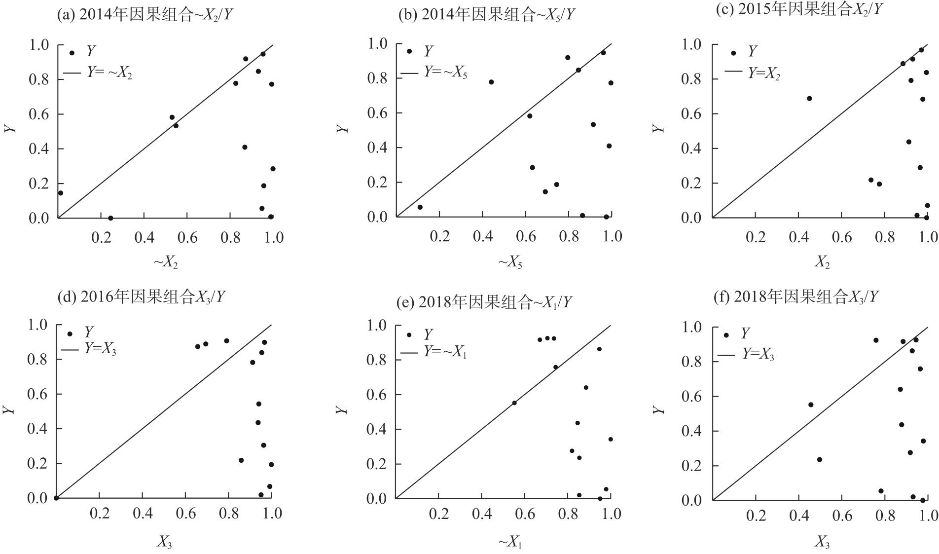
Causal combinations with inter-group consistency adjusted distance greater than 0.2"
| 因果组合 | 指标 | 2013年 | 2014年 | 2015年 | 2016年 | 2017年 | 2018年 | 2019年 | 2020年 | 2021年 | 2022年 | 2023年 | 2024年 |
|---|---|---|---|---|---|---|---|---|---|---|---|---|---|
| X1/Y | 一致性 | 0.72 | 0.82 | 0.52 | 0.51 | 0.75 | 0.33 | 0.45 | 0.56 | 0.53 | 0.72 | 0.76 | 0.70 |
| 覆盖度 | 0.63 | 0.56 | 0.79 | 0.59 | 0.56 | 0.93 | 0.92 | 0.63 | 0.64 | 0.68 | 0.63 | 0.68 | |
| ~X1/Y | 一致性 | 0.58 | 0.48 | 0.74 | 0.72 | 0.56 | 0.90 | 0.73 | 0.60 | 0.65 | 0.47 | 0.38 | 0.45 |
| 覆盖度 | 0.55 | 0.69 | 0.55 | 0.63 | 0.55 | 0.54 | 0.51 | 0.66 | 0.75 | 0.74 | 0.97 | 0.79 | |
| X2/Y | 一致性 | 0.80 | 0.27 | 0.97 | 0.54 | 0.43 | 0.52 | 0.51 | 0.74 | 0.77 | 0.54 | 0.71 | 0.64 |
| 覆盖度 | 0.63 | 0.52 | 0.54 | 0.64 | 0.59 | 0.61 | 0.62 | 0.68 | 0.76 | 0.72 | 0.94 | 0.80 | |
| ~X2/Y | 一致性 | 0.60 | 0.97 | 0.20 | 0.64 | 0.89 | 0.75 | 0.75 | 0.43 | 0.40 | 0.65 | 0.46 | 0.55 |
| 覆盖度 | 0.64 | 0.58 | 0.93 | 0.55 | 0.55 | 0.64 | 0.67 | 0.60 | 0.59 | 0.70 | 0.55 | 0.69 | |
| X3/Y | 一致性 | 0.60 | 0.64 | 0.47 | 0.93 | 0.78 | 0.96 | 0.82 | 0.45 | 0.45 | 0.46 | 0.31 | 0.40 |
| 覆盖度 | 0.65 | 0.59 | 0.56 | 0.55 | 0.53 | 0.57 | 0.62 | 0.56 | 0.77 | 0.72 | 0.72 | 0.78 | |
| ~X3/Y | 一致性 | 0.82 | 0.71 | 0.80 | 0.19 | 0.56 | 0.25 | 0.39 | 0.69 | 0.73 | 0.73 | 0.86 | 0.78 |
| 覆盖度 | 0.64 | 0.66 | 0.69 | 0.57 | 0.64 | 0.77 | 0.63 | 0.69 | 0.66 | 0.69 | 0.73 | 0.71 | |
| X4/Y | 一致性 | 0.78 | 0.80 | 0.43 | 0.45 | 0.52 | 0.47 | 0.58 | 0.61 | 0.64 | 0.70 | 0.70 | 0.68 |
| 覆盖度 | 0.65 | 0.55 | 0.70 | 0.84 | 0.60 | 0.72 | 0.64 | 0.68 | 0.71 | 0.67 | 0.72 | 0.74 | |
| ~X4/Y | 一致性 | 0.64 | 0.40 | 0.79 | 0.81 | 0.79 | 0.84 | 0.67 | 0.58 | 0.53 | 0.46 | 0.45 | 0.53 |
| 覆盖度 | 0.65 | 0.56 | 0.57 | 0.55 | 0.53 | 0.62 | 0.66 | 0.65 | 0.67 | 0.71 | 0.72 | 0.78 | |
| X5/Y | 一致性 | 0.63 | 0.33 | 0.73 | 0.55 | 0.35 | 0.89 | 0.73 | 0.79 | 0.87 | 0.53 | 0.62 | 0.17 |
| 覆盖度 | 0.58 | 0.62 | 0.57 | 0.59 | 0.90 | 0.56 | 0.52 | 0.66 | 0.63 | 0.79 | 0.73 | 1.00 | |
| ~X5/Y | 一致性 | 0.74 | 0.93 | 0.56 | 0.71 | 0.88 | 0.33 | 0.52 | 0.40 | 0.24 | 0.65 | 0.56 | 0.90 |
| 覆盖度 | 0.67 | 0.57 | 0.78 | 0.67 | 0.45 | 0.78 | 0.97 | 0.66 | 0.75 | 0.64 | 0.73 | 0.63 |
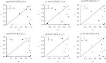
Fig. 5
Necessary condition test"
Tab. 6
Implementation of configurations with low water footprint intensity"
| 条件变量 | 低生产水足迹强度 | ||||
|---|---|---|---|---|---|
| 技术和种植结构双驱型 | 节水和管理协同型 | 技术主导型 | 管理和种植结构双驱型 | ||
| 组态A | 组态B | ||||
| X1 | ${\huge \bullet}$ | ${\huge \bullet}$ | ${\Large \otimes} $ | ${\huge \bullet}$ | ${\Large \otimes} $ |
| X2 | ${\huge \bullet}$ | ${\huge \bullet}$ | ${\huge \bullet}$ | ||
| X3 | $\otimes$ | $\bullet$ | ${\Large \otimes} $ | ||
| X4 | $\otimes$ | ${\huge \bullet}$ | ${\Large \otimes} $ | ${\huge \bullet}$ | |
| X5 | ${\Large \otimes} $ | $\otimes$ | |||
| 一致性 | 0.857 | 0.876 | 0.891 | 0.898 | 0.836 |
| PRI | 0.746 | 0.773 | 0.744 | 0.787 | 0.694 |
| 覆盖度 | 0.409 | 0.364 | 0.293 | 0.300 | 0.396 |
| 唯一覆盖度 | 0.039 | 0.013 | 0.023 | 0.020 | 0.051 |
| 组间一致性调整距离 | 0.144 | 0.066 | 0.097 | 0.086 | 0.117 |
| 组内一致性调整距离 | 0.356 | 0.331 | 0.319 | 0.327 | 0.418 |
| 总体一致性 | 0.78 | ||||
| 总体PRI | 0.641 | ||||
| 总体覆盖度 | 0.576 | ||||
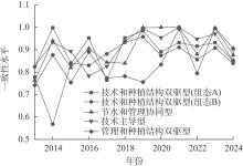
Fig. 6
Inter-group consistency level"
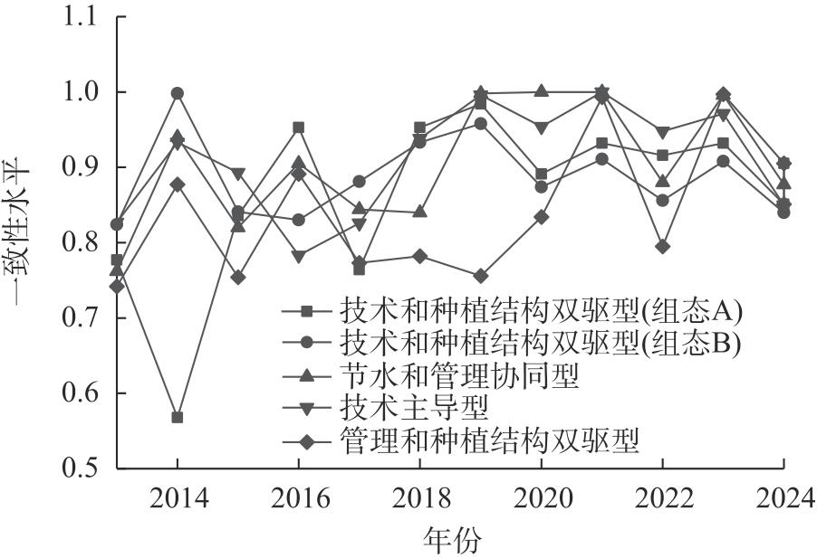
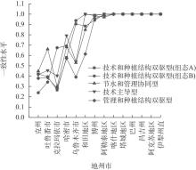
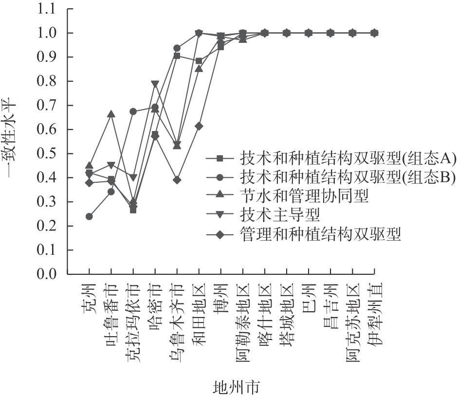
Fig. 7
Consistency levels of different configurations"
Tab. 7
Robustness test"
| 条件变量 | 提高案例频数 | 更换校准锚点 | |||||
|---|---|---|---|---|---|---|---|
| 组态1 | 组态2 | 组态3 | 组态1 | 组态2 | 组态3 | ||
| X1 | $\otimes$ | ${\huge \bullet}$ | ${\Large \otimes} $ | ${\huge \bullet}$ | ${\huge \bullet}$ | ${\huge \bullet}$ | |
| X2 | ${\huge \bullet}$ | ${\huge \bullet}$ | ${\huge \bullet}$ | ${\huge \bullet}$ | |||
| X3 | $\otimes$ | $\bullet$ | ${\Large \otimes} $ | ${\Large \otimes} $ | |||
| X4 | ${\huge \bullet}$ | ${\huge \bullet}$ | ${\huge \bullet}$ | ${\Large \otimes} $ | ${\Large \otimes} $ | ||
| X5 | ${\Large \otimes} $ | ${\huge \bullet}$ | $\otimes$ | ${\Large \otimes} $ | |||
| 一致性 | 0.836 | 0.857 | 0.891 | 0.847 | 0.807 | 0.828 | |
| PRI | 0.694 | 0.746 | 0.744 | 0.787 | 0.712 | 0.740 | |
| 覆盖度 | 0.396 | 0.409 | 0.293 | 0.215 | 0.118 | 0.126 | |
| 唯一覆盖度 | 0.053 | 0.117 | 0.030 | 0.136 | 0.013 | 0.021 | |
| 组间一致性调整距离 | 0.117 | 0.144 | 0.097 | 0.140 | 0.238 | 0.171 | |
| 组内一致性调整距离 | 0.418 | 0.356 | 0.319 | 0.518 | 0.492 | 0.596 | |
| 总体一致性 | 0.799 | 0.802 | |||||
| 总体PRI | 0.665 | 0.737 | |||||
| 总体覆盖度 | 0.543 | 0.275 | |||||
| [1] | 刘晓东, 彭晓彤, 白丽, 等. 水足迹视阈下河北省农业用水驱动因素分析[J]. 中国农业资源与区划, 2021, 42(11): 188-198. |
| [Liu Xiaodong, Peng Xiaotong, Bai Li, et al. Study on driving factors of agricultural water in Hebei Province based on water footprint[J]. Chinese Journal of Agricultural Resources and Regional Planning, 2021, 42(11): 188-198.] | |
| [2] | 中华人民共和国水利部. 中国节约用水报告2024[EB/OL]. [2025-07-23]. https://qgjsb.mwr.gov.cn/zyzx/jsbg/202507/t20250723_1973935.html. |
| [Ministry of Water Resources of the People’s Republic of China. China water conservation report in 2024[EB/OL]. [2025-07-23]. https://qgjsb.mwr.gov.cn/zyzx/jsbg/202507/t20250723_1973935.html.] | |
| [3] | 新疆维吾尔自治区人民政府. 新疆维吾尔自治区2024年国民经济和社会发展统计公报[EB/OL]. [2025-03-26]. https://www.xinjiang.gov.cn/xinjiang/tjgb/202503/f0578f74e4e04369af0ee82566586397.shtml. |
| [People’s Government of the Xinjiang Uygur Autonomous Region. Statistical communique on national economic and social development of the Xinjiang Uygur Autonomous Region in 2024[EB/OL]. [2025-03-26]. https://www.xinjiang.gov.cn/xinjiang/tjgb/202503/f0578f74e4e04369af0ee82566586397.shtml.] | |
| [4] |
Mekonnen M M, Hoekstra A Y. The green, blue and grey water footprint of crops and derived crop products[J]. Hydrology and Earth System Sciences, 2011, 15(5): 1577-1600.
doi: 10.5194/hess-15-1577-2011 |
| [5] |
闫晨健, 栗萌, 卓拉, 等. 1989-2019年陕西省作物生产水足迹时空演变与节水潜力评价[J]. 资源科学, 2023, 45(1): 158-173.
doi: 10.18402/resci.2023.01.12 |
|
[Yan Chenjian, Li Meng, Zhuo La, et al. Spatiotemporal evolution of water footprint and water-saving potentials of crop production in Shaanxi Province during 1989-2019[J]. Resources Science, 2023, 45(1): 158-173.]
doi: 10.18402/resci.2023.01.12 |
|
| [6] |
Mekonnen M M, Hoekstra A Y. Blue water footprint linked to national consumption and international trade is unsustainable[J]. Nature Food, 2020, 1(12): 792-800.
doi: 10.1038/s43016-020-00198-1 pmid: 37128061 |
| [7] | 江激宇, 刘嘉铭, 张士云. 淮河流域谷物生产水足迹及用水效率研究[J]. 农业资源与环境学报, 2024, 41(2): 371-382. |
| [Jiang Jiyu, Liu Jiaming, Zhang Shiyun. Study on the water footprint and water efficiency of cereal production in the Huai River Basin[J]. Journal of Agricultural Resources and Environment, 2024, 41(2): 371-382.] | |
| [8] | 王思雨. 基于水足迹的中型灌区种植结构优化研究——以三刘寨灌区为例[D]. 郑州: 华北水利水电大学, 2023. |
| [Wang Siyu. Optimization of planting structure in medium-sized irrigation areas based on water footprint: Take Sanliuzhai irrigation district as an example[D]. Zhengzhou: North China University of Water Resources and Electric Power, 2023.] | |
| [9] | 罗静怡, 东梅. 干旱区粮食生产用水驱动力解析与节水潜力评价——以宁夏为例[J/OL]. 中国农业资源与区划. [2025-08-18]. https://link.cnki.net/urlid/11.3513.S.20250818.1147.012. |
| [Luo Jingyi, Dong Mei. Analysis of driving forces of water use in grain production and evaluation of water-saving potential in dryland: A case study of Ningxia[J/OL]. Chinese Journal of Agricultural Resources and Regional Planning. [2025-08-18]. https://link.cnki.net/urlid/11.3513.S.20250818.1147.012.] | |
| [10] | 黄会平, 张冰, 李新生, 等. 海河流域农业水足迹分布及对气候变化的响应[J]. 人民黄河, 2019, 41(2): 64-75. |
| [Huang Huiping, Zhang Bing, Li Xinsheng, et al. Spatial-temporal characteristics agricultural water footprint in Haihe River Basin and its response to climate change[J]. Yellow River, 2019, 41(2): 64-75.] | |
| [11] | 李曼, 何巧凤, 刘焕才. 疏勒河流域中下游地区主要粮食作物生产水足迹变化及影响因素分析[J]. 节水灌溉, 2020(9): 94-105. |
| [Li Man, He Qiaofeng, Liu Huancai. Analysis of water footprint changes and influencing factors of main grain crops in the middle and lower reaches of the Shule River Basin[J]. Water Saving Irrigation, 2020(9): 94-105.] | |
| [12] |
Zeng W, He J C, Qiu Y L, et al. Unravelling the temporal-spatial distribution of the agricultural water footprint in the Yangtze River Basin (YRB) of China[J]. Water, 2021, 13(18): 25-62.
doi: 10.3390/w13010025 |
| [13] | 王倩, 黄凯. 基于系统动力学的北京市农业水足迹模拟与影响因素分析[J]. 系统工程, 2021, 39(3): 13-24. |
| [Wang Qian, Huang Kai. Simulation of agricultural water footprint and analysis of influencing factors in Beijing based on system dynamic[J]. Systems Engineering, 2021, 39(3): 13-24.] | |
| [14] | 郭相平, 高爽, 吴梦洋, 等. 中国农作物水足迹时空分布与影响因素分析[J]. 农业机械学报, 2018, 49(5): 295-302. |
| [Guo Xiangping, Gao Shuang, Wu Mengyang, et al. Analysis of temporal-spatial distribution and influencing factors of water footprint in crop production system of China[J]. Transactions of the Chinese Society for Agricultural Machinery, 2018, 49(5): 295-302.] | |
| [15] | 金谦, 桂东伟, 高霄鹏, 等. 新疆主要农作物生产水足迹研究[J]. 干旱地区农业研究, 2018, 36(6): 243-249. |
| [Jin Qian, Gui Dongwei, Gao Xiaopeng, et al. Water footprints of primary crop production in Xinjiang[J]. Agricultural Research in the Arid Areas, 2018, 36(6): 243-249.] | |
| [16] | 蒙克, 魏必. 反思qca方法的“时间盲区”: 为公共管理研究找回“时间”[J]. 中国行政管理, 2023(1): 96-104. |
| [Meng Ke, Wei Bi. Rethinking the “time blindness” of the qualitative comparative analysis: Bringing back “time” for public management research[J]. Chinese Administration Society, 2023(1): 96-104.] | |
| [17] |
张沛, 龙爱华, 海洋, 等. 1988-2015年新疆农业用水时空变化与政策驱动研究——基于农作物水足迹的统计分析[J]. 冰川冻土, 2021, 43(1): 242-253.
doi: 10.7522/j.issn.1000-0240.2018.1058 |
| [Zhang Pei, Long Aihua, Hai Yang, et al. Spatiotemporal variations and driving forces of agricultural water consumption in Xinjiang during 1988-2015: Based on statistical analysis of crop water footprint[J]. Journal of Glaciology and Geocryology, 2021, 43(1): 242-253.] | |
| [18] | 新疆维吾尔自治区水利厅. 水利厅加快推进新疆“十五五”水安全保障规划编制工作[EB/OL]. [2025-06-13]. https://slt.xinjiang.gov.cn/xjslt/c114428/202506/39344aa2b4fe482d9be0ed7ea4363e79.shtml. |
| [Water Resources Department of the Xinjiang Uygur Autonomous Region. The department accelerates the formulation of Xinjiang’s 15th Five-Year Plan for water security guarantee[EB/OL]. [2025-06-13]. https://slt.xinjiang.gov.cn/xjslt/c114428/202506/39344aa2b4fe482d9be0ed7ea4363e79.shtml.] | |
| [19] | 国家气象信息中心. 中国地面气象观测数据[EB/OL]. [2025-09-13]. https://data.cma.cn/data/detail/dataCode/A.0012.0001.S011.html. |
| [National Meteorological Information Center. China surface meteorological observation data[EB/OL]. [2025-09-13]. https://data.cma.cn/data/detail/dataCode/A.0012.0001.S011.html.] | |
| [20] | 新疆维吾尔自治区统计局. 新疆统计年鉴[DB/OL]. [2025-09-13]. https://tjj.xinjiang.gov.cn/tjj/tjfw/list_tjfw.shtml. |
| [Statistics Bureau of the Xinjiang Uygur Autonomous Region. Xinjiang statistical yearbook[DB/OL]. [2025-09-13]. https://tjj.xinjiang.gov.cn/tjj/tjfw/list_tjfw.shtml.] | |
| [21] |
何旭刚, 买买提·沙吾提, 夏梓洋, 等. 1960-2020年新疆主要作物需水量时空特征分析[J]. 作物学报, 2023, 49(12): 3352-3363.
doi: 10.3724/SP.J.1006.2023.31007 |
|
[He Xugang, Shawuti Memet, Xia Ziyang, et al. Spatio-temporal characteristics of water requirement of main crops in Xinjiang from 1960 to 2020[J]. Acta Agronomica Sinica, 2023, 49(12): 3352-3363.]
doi: 10.3724/SP.J.1006.2023.31007 |
|
| [22] | 郑永丹. 中国主要粮食作物生育期时空格局及其变化[D]. 武汉: 华中师范大学, 2016. |
| [Zheng Yongdan. Research on the spatial-temporal distribution of the growth period of main grain crops and its change in China[D]. Wuhan: Central China Normal University, 2016.] | |
| [23] | 林馨园, 许峰, 马学花, 等. 1990-2020年塔里木河流域五地州不同作物生产与种植结构的分析与评价——基于水足迹的视角[J]. 中国农业资源与区划, 2024, 45(9): 196-205. |
| [Lin Xinyuan, Xu Feng, Ma Xuehua, et al. Analysis and evaluation of different crop production and planting structure in five prefectures of Tarim River Basin from 1990 to 2020: Based on water footprint[J]. Chinese Journal of Agricultural Resources and Regional Planning, 2024, 45(9): 196-205.] | |
| [24] | 中华人民共和国生态环境部. 地表水环境质量标准[EB/OL]. [2002-06-01]. https://www.mee.gov.cn/ywgz/fgbz/bz/bzwb/shjbh/shjzlbz/200206/t20020601_66497.shtml. |
| [Ministry of Ecology and Environment of the People’s Republic of China. Environmental quality standard for surface water[EB/OL]. [2002-06-01]. https://www.mee.gov.cn/ywgz/fgbz/bz/bzwb/shjbh/shjzlbz/200206/t20020601_66497.shtml.] | |
| [25] | 徐依婷, 穆月英. 粮食生产水足迹动态演变及分解效应[J]. 华南农业大学学报(社会科学版), 2020, 19(3): 70-83. |
| [Xu Yiting, Mu Yueying. Dynamic change and decomposition effects of water footprint in grain production[J]. Journal of South China Agricultural University (Social Science Edition), 2020, 19(3): 70-83.] | |
| [26] | 尹朝静, 廖培森, 葛静芳, 等. 中国农业全要素水资源绿色生产率的区域差异、动态演进及收敛性[J]. 干旱区资源与环境, 2025, 39(2): 107-116. |
| [Yin Chaojing, Liao Peisen, Ge Jingfang, et al. Regional differences, dynamic evolution and convergence of agricultural total factor water green productivity in China[J]. Journal of Arid Land Resources and Environment, 2025, 39(2): 107-116.] | |
| [27] | 吴志旻, 刘静. 不同小型农田水利设施管护模式对水稻生产率的影响研究[J]. 农业技术经济, 2025(10): 91-111. |
| [Wu Zhimin, Liu Jing. The impact of different maintenance modes of small-scale farmland water conservancy facilities on rice productivity[J]. Journal of Agrotechnical Economics, 2025(10): 91-111. | |
| [28] | 刘继龙, 吴耀宇, 曹晓强, 等. 三江平原地区农作物水足迹时空演变特征及可持续性利用评价[J]. 东北农业大学学报, 2023, 54(8): 68-78. |
| [Liu Jilong, Wu Yaoyu, Cao Xiaoqiang, et al. Temporal and spatial evolution characteristics of agricultural water footprint of crops in the Sanjiang Plain and evaluation on sustainable utilization[J]. Journal of Northeast Agricultural University, 2023, 54(8): 68-78.] | |
| [29] |
Fiss P C. Building better causal theories: A fuzzy set approach to typologies in organization research[J]. Academy of Management Journal, 2011, 54(2): 393-420.
doi: 10.5465/amj.2011.60263120 |
| [30] | 杜运周, 刘秋辰, 程建青. 什么样的营商环境生态产生城市高创业活跃度?--基于制度组态的分析[J]. 管理世界, 2020, 36(9): 141-155. |
| [Du Yunzhou, Liu Qiuchen, Cheng Jianqing. What kind of business environment ecology generates high urban entrepreneurial activity? An analysis based on institutional configuration[J]. Journal of Management World, 2020, 36(9): 141-155.] | |
| [31] | 张放. 影响地方政府信息公开的因素——基于省域面板数据的动态QCA分析[J]. 情报杂志, 2023, 42(1): 133-141. |
| [Zhang Fang. Determinants of local governments’ information disclosure: A dynamic QCA analysis based on provincial panel data[J]. Journal of Intelligence, 2023, 42(1): 133-141.] | |
| [32] | 中华人民共和国农业农村部. 国家发布2014年棉花目标价格[EB/OL]. [2014-04-05]. https://www.moa.gov.cn/xw/zwdt/201404/t20140405_3841790.htm. |
| [Ministry of Agriculture and Rural Affairs of the People’s Republic of China. The state issued the 2014 target price for cotton[EB/OL]. [2014-04-05]. https://www.moa.gov.cn/xw/zwdt/201404/t20140405_3841790.htm.] | |
| [33] |
杨巨星, 孙慧, 周晋楠, 等. 中国资源型城市转型脱碳时空演进及路径选择[J]. 干旱区地理, 2026, 49(1): 151-163.
doi: 10.12118/j.issn.1000-6060.2024.743 |
|
[Yang Juxing, Sun Hui, Zhou Jinnan, et al. Spatio-temporal evolution and pathway selection of transformation decarbonization in China’s resource-based cities[J]. Arid Land Geography, 2026, 49(1): 151-163.]
doi: 10.12118/j.issn.1000-6060.2024.743 |
|
| [34] |
程鹏, 彭海洋, 侯丁榕, 等. 黄河流域农业灰水足迹强度空间格局及演进趋势[J]. 干旱区地理, 2025, 48(7): 1185-1197.
doi: 10.12118/j.issn.1000-6060.2024.473 |
|
[Cheng Peng, Peng Haiyang, Hou Dingrong, et al. Spatial pattern and evolution trend of agricultural grey water footprint intensity in the Yellow River Basin[J]. Arid Land Geography, 2025, 48(7): 1185-1197.]
doi: 10.12118/j.issn.1000-6060.2024.473 |
|
| [35] |
褚家琦, 蒋志辉. 新疆农业水资源绿色效率时空演变及影响因素研究[J]. 干旱区地理, 2024, 47(7): 1231-1241.
doi: 10.12118/j.issn.1000-6060.2023.577 |
|
[Chu Jiaqi, Jiang Zhihui. Spatiotemporal evolution and influencing factors of green efficiency of agricultural water resources in Xinjiang[J]. Arid Land Geography, 2024, 47(7): 1231-1241.]
doi: 10.12118/j.issn.1000-6060.2023.577 |
| [1] | JIAO Shitang, YAN Yang, ZHENG Jianghua, HE Ying, Babierjiang DILIXIATI, WEI Jianxin, LIU Junhao, SHE Yongrui. Impact characteristics and driving factors of wind farms on the ecological environment in Xinjiang [J]. Arid Land Geography, 2026, 49(9): 1840-1854. |
| [2] | TONG Yanjun, YUAN Lu, LEI Jun. Coupled and coordinated relationships between population, socio-economic, and resource-environment in Xinjiang’s border areas under the background of border security [J]. Arid Land Geography, 2026, 49(8): 1626-1639. |
| [3] | LU Zhiqiu, LYU Mingyang, LI Zhihui, XU Liping. Multi-dimensional evaluation and temporal evolution of urban-rural integration development in Xinjiang from the perspective of “people-land-industry” [J]. Arid Land Geography, 2026, 49(8): 1750-1763. |
| [4] | WANG Ziyang, XIA Yong, WANG Fuhong, DING Ning, LYU Yi, SU Zechen. Spatiotemporal evolution and driving factors of ecological efficiency of cultivated land use in counties of Xinjiang [J]. Arid Land Geography, 2026, 49(7): 1385-1394. |
| [5] | CHEN Yaning, ZHU Chenggang, LI Zhi, FANG Gonghuan. Unlocking the potential of water resources for high-quality development in Xinjiang [J]. Arid Land Geography, 2026, 49(6): 1101-1107. |
| [6] | LIU Xiao, ZHANG Xinhuan, CHEN Yang, YAN Hailong. Measurement of spatial conditions for urban-rural integration in Xinjiang from the perspective of “township-county-oasis” [J]. Arid Land Geography, 2026, 49(5): 1039-1051. |
| [7] | BAI Yang, ZHAO Ping, LI Yongfeng, CHEN Mingzhu, SUN Yiyue. Spatial synergistic zoning of geotourism in Xinjiang [J]. Arid Land Geography, 2026, 49(5): 1074-1086. |
| [8] | CHEN Wenxuan, CHEN Yu, WANG Shenglong. Characteristics of spatial and temporal evolution of agricultural carbon emissions in the Yellow River Basin and analysis of its influencing factors [J]. Arid Land Geography, 2026, 49(4): 713-726. |
| [9] | LIU Fajian, LIANG Wanxin, HUANG Chaoqun, LI Songyuan, ZHANG Bohan. Spatiotemporal evolution characteristics and driving factors of tourism new quality productivity development in China [J]. Arid Land Geography, 2026, 49(3): 429-439. |
| [10] | ZHU Yiting, LIANG Guixian, ZHOU Chunshan, XIN Long, LI Jinxue. Spatiotemporal evolution characteristics and driving factors of new quality productive forces development of cultural tourism in Xinjiang [J]. Arid Land Geography, 2026, 49(1): 128-139. |
| [11] | Alim ARKEN, LI Ruqi, Nurzat ABDUKEYUM, Mayra AHAT, Xerinay TILIWALDI. Characteristics of rainfall and extreme rainfall in southern Xinjiang from 1961 to 2022 [J]. Arid Land Geography, 2026, 49(1): 13-22. |
| [12] | YANG Di, ZOU Jin, MA Xiaofei, ZHANG Xun, ZHOU Rui, LIU Yanchun, SHI Jinlian. Spatial distribution characteristics and sustainable development of sports tourism resources: A case of Xinjiang [J]. Arid Land Geography, 2026, 49(1): 140-150. |
| [13] | LIU Quanyu, LIU Xinlu, LI Guizhen, LI Congjuan. Fractal characteristics and driving factors of soil particle size in the surface layer of Xinjiang [J]. Arid Land Geography, 2026, 49(1): 56-68. |
| [14] | LI Liangliang, XIA Yong, WANG Fuhong, GUO Bingxin, ZHAO Lanlan. Muskmelon production pattern and its contributing factors in Xinjiang [J]. Arid Land Geography, 2025, 48(9): 1567-1577. |
| [15] | RUI Dongsheng, MAO Lu, REN Yanxia, GONG Haoxuan, LI Yanping, FU Zhicong. Spatial distribution characteristics and obstacle factors of relative poverty in Xinjiang [J]. Arid Land Geography, 2025, 48(9): 1672-1682. |
|
||

