Arid Land Geography ›› 2026, Vol. 49 ›› Issue (9): 1815-1825.doi: 10.12118/j.issn.1000-6060.2025.685
• Ecology and Environment • Previous Articles Next Articles
LI Xiaopeng( ), JIA Fugui, LEI Shuang, LI Kang
Received:2025-10-27
Revised:2025-12-20
Online:2026-09-25
Published:2026-09-07
LI Xiaopeng, JIA Fugui, LEI Shuang, LI Kang. Spatiotemporal evolution characteristics and disaster-inducing factors of crop disasters in the Yellow River Basin[J].Arid Land Geography, 2026, 49(9): 1815-1825.
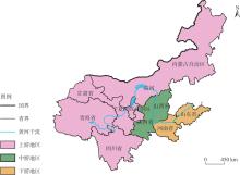
Fig. 1
Schematic diagram of the study area"
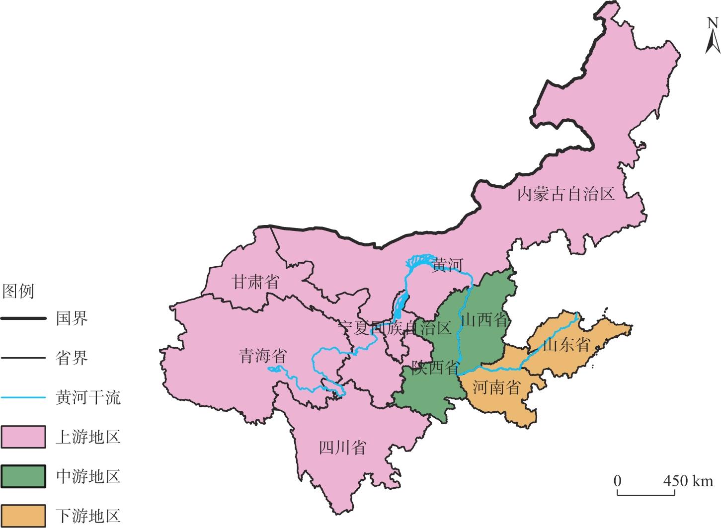
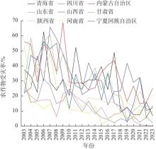
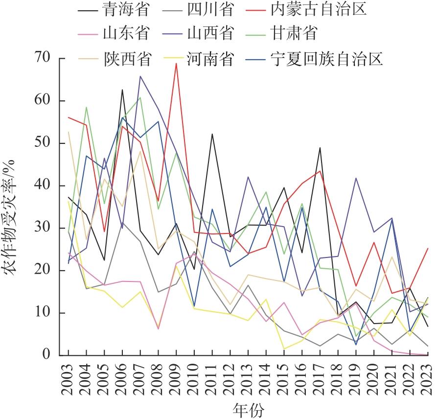
Fig. 2
Interannual variation of crop disaster rate in the Yellow River Basin from 2003 to 2023"

Tab. 1
Changes in center of gravity migration and standard deviational ellipse parameters of crop disaster rate in the Yellow River Basin from 2003 to 2023"
| 年份 | 面积/km2 | 重心经度坐标/E | 重心纬度坐标/N | 长轴标准差/km | 短轴标准差/km | 方位角/(°) |
|---|---|---|---|---|---|---|
| 2003 | 2487364.82 | 108°12′39″ | 37°00′10″ | 1139.95 | 694.60 | 63.53 |
| 2006 | 2187929.48 | 105°57′14″ | 37°15′57″ | 1156.14 | 602.44 | 65.59 |
| 2009 | 2342105.75 | 108°20′20″ | 37°58′54″ | 1136.42 | 656.07 | 63.54 |
| 2012 | 2359789.13 | 107°25′28″ | 37°32′34″ | 1196.27 | 627.96 | 71.06 |
| 2015 | 2248888.71 | 106°46′15″ | 37°57′41″ | 1250.20 | 572.64 | 68.08 |
| 2018 | 2241325.94 | 108°51′27″ | 38°18′14″ | 1099.77 | 648.76 | 62.92 |
| 2021 | 1403005.99 | 108°22′06″ | 37°20′54″ | 845.88 | 528.00 | 69.18 |
| 2023 | 2101323.99 | 109°06′47″ | 38°14′37″ | 1035.23 | 646.15 | 51.73 |
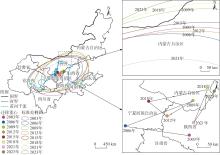
Fig. 3
Migration path of the center of gravity and standard deviational ellipse of crop disaster rate in the Yellow River Basin from 2003 to 2023"
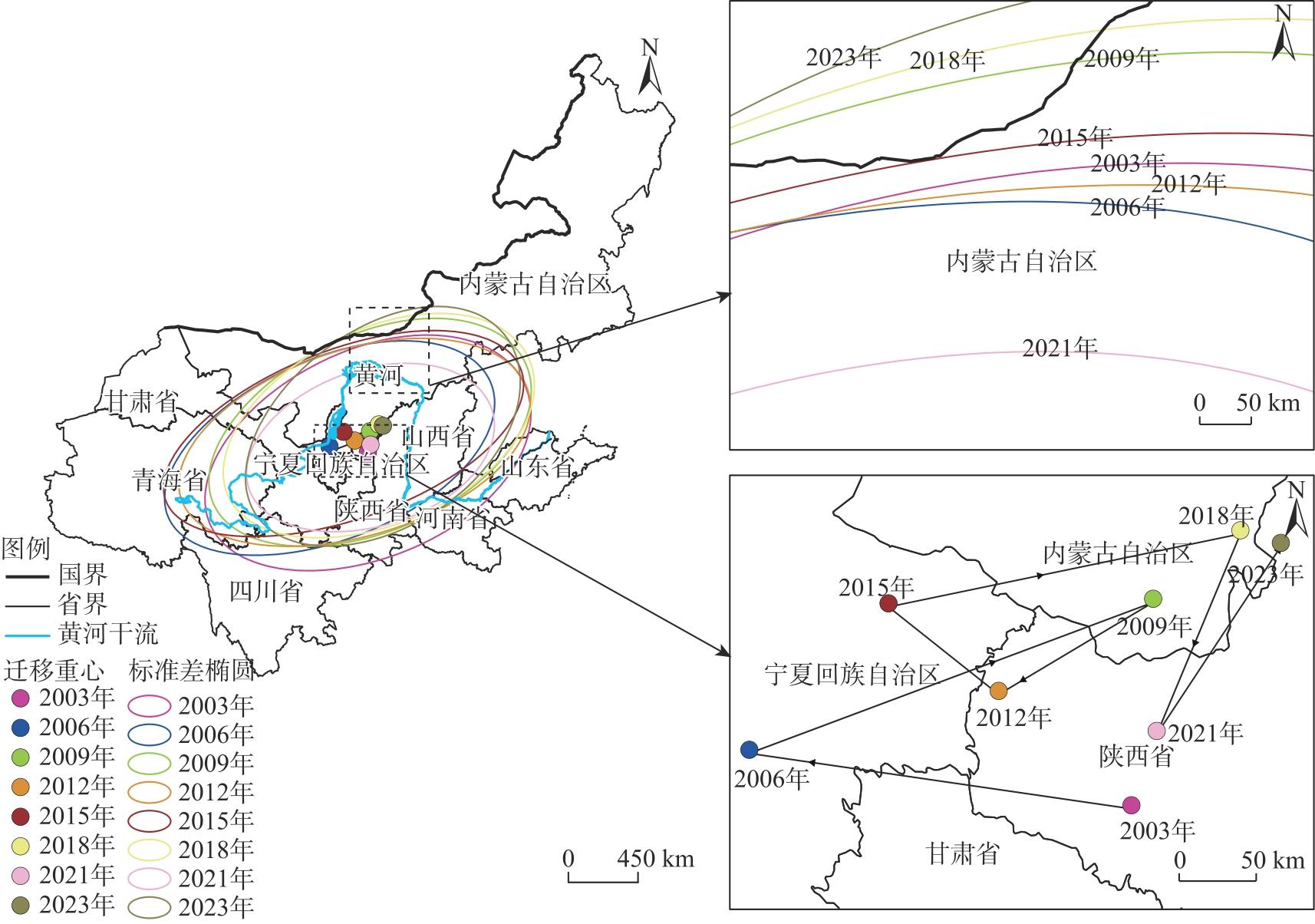
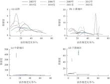
Fig. 4
Kernel density estimation of crop disaster rate in the Yellow River Basin from 2003 to 2023"
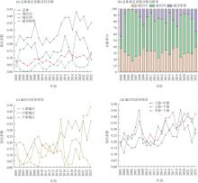
Fig. 5
Evolution of regional differences in crop disaster rate in the Yellow River Basin from 2003 to 2023"

Tab. 2
Collinearity diagnosis of explanatory variables in the GTWR model for crop disaster rate in the Yellow River Basin from 2003 to 2023"
| 指标 | 共线性诊断 | |
|---|---|---|
| 显著性 | 方差膨胀因子(VIF) | |
| 年均降水量 | 0.003 | 5.661 |
| 森林覆盖率 | 0.001 | 4.890 |
| 海拔 | 0.001 | 5.920 |
| 坡度 | 0.001 | 7.063 |
| 水库数量 | 0.003 | 3.107 |
| 水土流失治理面积 | 0.734 | 1.957 |
Tab. 3
Model comparison"
| 模型 | OLS | GWR | GTWR |
|---|---|---|---|
| AICc | -242.290 | -281.412 | -310.473 |
| R2 | 0.355 | 0.551 | 0.726 |
| 调整后R2 | - | 0.539 | 0.718 |
Tab. 4
Interannual variation of regression coefficients for explanatory variables in the GTWR model of crop disaster rate in the Yellow River Basin from 2003 to 2023"
| 指标 | 2003年 | 2006年 | 2009年 | 2012年 | 2015年 | 2018年 | 2021年 | 2023年 |
|---|---|---|---|---|---|---|---|---|
| 年均降水量 | -0.00028 | -0.00053 | -0.00060 | -0.00026 | -0.00030 | -0.00020 | -0.00006 | -0.00003 |
| 森林覆盖率 | 0.00344 | -0.00082 | -0.00379 | -0.00423 | -0.00124 | -0.00048 | -0.00089 | 0.00090 |
| 海拔 | 0.00001 | -0.00005 | -0.00009 | -0.00003 | -0.00001 | 0.00003 | -0.00004 | -0.00002 |
| 坡度 | -0.00180 | 0.03088 | 0.04796 | 0.02457 | 0.01229 | 0.01310 | 0.01950 | 0.00723 |
| 水库数量 | -0.00002 | -0.00001 | -0.00001 | -0.00001 | -0.00001 | -0.00002 | -0.00002 | -0.00002 |
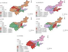
Fig. 6
Spatial heterogeneity of regression coefficients in the GTWR model for disaster-inducing factors of crop disaster rate in the Yellow River Basin from 2003 to 2023"

| [1] | 李晓鹏, 贾富贵, 李康, 等. 甘肃省农作物受灾率的时空演变特征及其影响因素[J]. 中国农业气象, 2026, 47(4): 603-615. |
|
[Li Xiaopeng, Jia Fugui, Li Kang, et al. Spatiotemporal evolution characteristics and influencing factors of crop disaster rates by meteorological disaster in Gansu Province[J]. Chinese Journal of Agrometeorology, 2026, 47(4): 603-615.]
doi: 10.3969/j.issn.1000-6362.2026.04.011 |
|
| [2] | 李贤, 王浩阳, 牛文浩, 等. 黄河流域耕地利用转型时空演变及其对粮食生产的影响[J]. 中国农业大学学报, 2024, 29(10): 85-96. |
| [Li Xian, Wang Haoyang, Niu Wenhao, et al. Spatial-temporal evolution of cultivated land use transition and its impact on grain production in the Yellow River Basin[J]. Journal of China Agricultural University, 2024, 29(10): 85-96.] | |
| [3] | 资添添, 刘静, 宣柯炀. 基于SWAT模型的黄河流域作物水足迹及虚拟水流动研究[J]. 灌溉排水学报, 2025, 44(2): 19-26. |
| [Zi Tiantian, Liu Jing, Xuan Keyang. Modelling crop water footprint and virtual water flow in the Yellow River Basin using the SWAT model[J]. Journal of Irrigation and Drainage, 2025, 44(2): 19-26.] | |
| [4] | 薛选登, 范晓婕, 谢清华. 农业水资源生态韧性时空演化及多尺度障碍因子分析——以黄河流域9省区为例[J]. 中国农业资源与区划, 2025, 46(2): 91-102. |
| [Xue Xuandeng, Fan Xiaojie, Xie Qinghua. Spatio-temporal evolution and multi-scale barrier factor analysis of ecological resilience of agricultural water resources: A case study of nine provinces in the Yellow River Basin[J]. Chinese Journal of Agricultural Resources and Regional Planning, 2025, 46(2): 91-102.] | |
| [5] | 占纪文, 郑思宁, 徐学荣. 农作物巨灾风险度量与分层测算[J]. 统计与决策, 2020, 36(3): 37-41. |
| [Zhan Jiwen, Zheng Sining, Xu Xuerong. Crop catastrophe risk measurement and its stratified calculation[J]. Statistics & Decision, 2020, 36(3): 37-41.] | |
| [6] | 秦鹏程, 周月华, 刘火胜, 等. 基于水动力模型的农作物暴雨洪涝灾害损失评估: 以江汉平原为例[J]. 中国农业气象, 2025, 46(3): 420-431. |
|
[Qin Pengcheng, Zhou Yuehua, Liu Huosheng, et al. Flood loss assessment for crops based on hydrodynamic modeling: A case study in the Jianghan Plain[J]. Chinese Journal of Agrometeorology, 2025, 46(3): 420-431.]
doi: 10.3969/j.issn.1000-6362.2025.03.013 |
|
| [7] | 金欣, 闫格, 李军乔, 等. 青海省春播期气候特征及主要气象灾害影响预估[J]. 干旱地区农业研究, 2025, 43(3): 270-277, 298. |
| [Jin Xin, Yan Ge, Li Junqiao, et al. Climatic characteristics and impact assessment of major meteorological disasters during the spring sowing period in Qinghai Province[J]. Agricultural Research in the Arid Areas, 2025, 43(3): 270-277, 298.] | |
| [8] | 张波, 罗阳欢, 李浪, 等. 贵州茶树春季低温灾害气候风险评估与区划[J]. 中国农业科技导报(中英文), 2025, 27(4): 230-238. |
| [Zhang Bo, Luo Yanghuan, Li Lang, et al. Climate risk assessment and zoning of spring low temperature disasters of tea trees in Guizhou[J]. Journal of Agricultural Science and Technology, 2025, 27(4): 230-238.] | |
| [9] | 伍红雨, 邹燕, 郭尧. 损失率评估模型在广东气象灾害损失评估中的应用[J]. 气象, 2023, 49(6): 757-764. |
| [Wu Hongyu, Zou Yan, Guo Xiao. Application of loss rate evaluation model in meteorological disaster loss evaluation in Guangdong[J]. Meteorological Monthly, 2023, 49(6): 757-764.] | |
| [10] | 李治国. 近40 a河南省农业气象灾害对粮食生产的影响研究[J]. 干旱区资源与环境, 2013, 27(5): 126-130. |
| [Li Zhiguo. Influence of agricultural meteorological disasters on grain production in Henan Province[J]. Journal of Arid Land Resources and Environment, 2013, 27(5): 126-130.] | |
| [11] | 于小兵, 陈虹, 吉中会, 等. 山东省农业气象灾害与主要农作物产量的灰色关联分析[J]. 灾害学, 2019, 34(3): 103-108. |
| [Yu Xiaobing, Chen Hong, Ji Zhonghui, et al. Gray correlation analysis of agricultural meteorological disasters and main crop yields in Shandong Province[J]. Journal of Catastrophology, 2019, 34(3): 103-108.] | |
| [12] | 高姣姣, 徐刚. 重庆市气象灾害与农作物单产的灰色关联度分析[J]. 西南大学学报(自然科学版), 2016, 38(2): 32-36. |
| [Gao Jiaojiao, Xu Gang. Gray correlation analysis of meteorological disasters and crop yield in Chongqing[J]. Journal of Southwest University (Natural Science Edition), 2016, 38(2): 32-36.] | |
| [13] | 李忠辉, 袁福香, 刘实, 等. 基于“Z指数”的吉林省雨涝灾害对农作物的影响评估[J]. 安全与环境学报, 2016, 16(1): 183-186. |
| [Li Zhonghui, Yuan Fuxiang, Liu Shi, et al. On the crop-harvest assessment with regard to the waterlog disasters in Jilin with “Z-index” method[J]. Journal of Safety and Environment, 2016, 16(1): 183-186.] | |
| [14] | 楚纯洁, 张小磊, 周金风. 1960-2018年河南省短周期旱涝急转事件演变特征[J]. 水土保持研究, 2023, 30(4): 275-285. |
| [Chu Chunjie, Zhang Xiaolei, Zhou Jinfeng. Evolution characteristics of short-period drought-flood abrupt alternation events in Henan Province from 1960 to 2018[J]. Research of Soil and Water Conservation, 2023, 30(4): 275-285.] | |
| [15] |
曹永强, 杨雪婷, 周姝含. 河北省夏玉米水足迹时空演变特征及影响因子分析[J]. 长江科学院院报, 2023, 40(2): 67-74, 80.
doi: 10.11988/ckyyb.20210993 |
| [Cao Yongqiang, Yang Xueting, Zhou Shuhan. Spatial and temporal evolution and influencing factors of water footprint of summer maize in Hebei Province[J]. Journal of Changjiang River Scientific Research Institute, 2023, 40(2): 67-74, 80.] | |
| [16] | 何延波, 李祎君, 张艳红, 等. 2025年夏季气象条件对农业生产的影响[J]. 中国农业气象, 2025, 46(12): 1836-1838. |
|
[He Yanbo, Li Yijun, Zhang Yanhong, et al. Reports on weather impacts to agricultural production in summer 2025[J]. Chinese Journal of Agrometeorology, 2025, 46(12): 1836-1838.]
doi: 10.3969/j.issn.1000-6362.2025.12.014 |
|
| [17] | 于水, 张晓龙, 王妍, 等. 气候变化对中国东北三省主要粮食作物影响研究综述[J]. 中国生态农业学报(中英文), 2024, 32(6): 970-985. |
| [Yu Shui, Zhang Xiaolong, Wang Yan, et al. Review of research on the impacts of climate change on staple grain crops in the three provinces of northeast China[J]. Chinese Journal of Eco-Agriculture, 2024, 32(6): 970-985.] | |
| [18] | 孔冬艳, 陈会广. 近40年来中国农作物与耕地受灾时空特征及影响因素分析[J]. 长江流域资源与环境, 2020, 29(5): 1236-1246. |
| [Kong Dongyan, Chen Huiguang. An analysis of spatial-temporal characteristics and influencing factors for China’s crop and cropland suffered natural disaster in recent 40 years[J]. Resources and Environment in the Yangtze Basin, 2020, 29(5): 1236-1246.] | |
| [19] |
程鹏, 彭海洋, 侯丁榕, 等. 黄河流域农业灰水足迹强度空间格局及演进趋势[J]. 干旱区地理, 2025, 48(7): 1185-1197.
doi: 10.12118/j.issn.1000-6060.2024.473 |
|
[Cheng Peng, Peng Haiyang, Hou Dingrong, et al. Spatial pattern and evolution trend of agricultural grey water footprint intensity in the Yellow River Basin[J]. Arid Land Geography, 2025, 48(7): 1185-1197.]
doi: 10.12118/j.issn.1000-6060.2024.473 |
|
| [20] |
李梦冉, 徐小任, 王梁, 等. 黄河流域农业碳排放时空变化特征及影响因素分析[J]. 干旱区地理, 2025, 48(5): 854-865.
doi: 10.12118/j.issn.1000-6060.2024.401 |
|
[Li Mengran, Xu Xiaoren, Wang Liang, et al. Spatial-temporal characteristics and influencing factors of agricultural carbon emissions in the Yellow River Basin[J]. Arid Land Geography, 2025, 48(5): 854-865.]
doi: 10.12118/j.issn.1000-6060.2024.401 |
|
| [21] | 马志超. 黄河流域农业碳排放与经济增长时空耦合关系研究[J]. 中国农业资源与区划, 2024, 45(12): 15-26. |
| [Ma Zhichao. Spatio-temporal coupling relationship between agricultural carbon emission and economic growth in the Yellow River Basin[J]. Chinese Journal of Agricultural Resources and Regional Planning, 2024, 45(12): 15-26.] | |
| [22] | 杨宗辉, 李金锴, 韩晨雪, 等. 我国粮食生产重心变迁及其影响因素研究[J]. 农业现代化研究, 2019, 40(1): 36-43. |
| [Yang Zonghui, Li Jinkai, Han Chenxue, et al. The evolution path of China’s grain production base and the influencing factors[J]. Research of Agricultural Modernization, 2019, 40(1): 36-43.] | |
| [23] |
刘宝涛. 京津冀城市群建设用地转型的时空演化与驱动因素[J]. 世界地理研究, 2025, 34(7): 98-111.
doi: 10.3969/j.issn.1004-9479.2025.07.20230744 |
|
[Liu Baotao. Spatial-temporal evolution and driving factors of construction land transformation in the Beijing-Tianjin-Hebei urban agglomeration[J]. World Regional Studies, 2025, 34(7): 98-111.]
doi: 10.3969/j.issn.1004-9479.2025.07.20230744 |
|
| [24] |
Kumar S, Russell R. Technological change, technological catch-up, and capital deepening: Relative contributions to growth and convergence[J]. The American Economic Review, 2002, 92(3): 527-548.
doi: 10.1257/00028280260136381 |
| [25] | 向云, 李芷萱, 陆倩. 中国农业经济高质量发展的空间非均衡及收敛性[J]. 中国农业大学学报, 2022, 27(11): 305-316. |
| [Xiang Yun, Li Zhixuan, Lu Qian. Spatial disequilibrium and convergence of high quality development of agricultural economy in China[J]. Journal of China Agricultural University, 2022, 27(11): 305-316.] | |
| [26] | 张军涛, 韩祁祺. 黄河流域农业碳排放时空演变特征及影响因素研究[J]. 环境科学研究, 2025, 38(4): 754-766. |
| [Zhang Juntao, Han Qiqi. Spatiotemporal evolution characteristics and influencing factors of agricultural carbon emissions in the Yellow River Basin[J]. Research of Environmental Sciences, 2025, 38(4): 754-766.] | |
| [27] |
刘艺欣, 裴婷婷, 陈英, 等. 基于县域尺度的甘肃省乡村振兴发展水平测度及时空分异[J]. 干旱区地理, 2025, 48(9): 1683-1693.
doi: 10.12118/j.issn.1000-6060.2024.545 |
|
[Liu Yixin, Pei Tingting, Chen Ying, et al. Measurement and spatial-temporal differentiation of rural revitalization development level in Gansu Province based on county scale[J]. Arid Land Geography, 2025, 48(9): 1683-1693.]
doi: 10.12118/j.issn.1000-6060.2024.545 |
|
| [28] |
Huang B, Wu B, Barry M. Geographically and temporally weighted regression for modeling spatio-temporal variation in house prices[J]. International Journal of Geographical Information Science, 2010, 24(3): 383-401.
doi: 10.1080/13658810802672469 |
| [29] | 姚寿福. 我国农业资金投入对抗灾能力的效应分析[J]. 农业现代化研究, 2012, 33(2): 161-165. |
| [Yao Shoufu. An analysis of effects of agricultural investments on anti-disaster ability in China[J]. Research of Agricultural Modernization, 2012, 33(2): 161-165.] | |
| [30] | 杨建利, 邹雨潼, 宋大威. 黄河流域农业高质量发展水平测度、地区差异及动态演进[J]. 中国农业资源与区划, 2024, 45(10): 212-227. |
| [Yang Jianli, Zou Yutong, Song Dawei. The measurement and regional difference and dynamic evolution of high-quality development of agriculture in the Yellow River Basin[J]. Chinese Journal of Agricultural Resources and Regional Planning, 2024, 45(10): 212-227.] | |
| [31] | 周帅, 王义民, 畅建霞, 等. 黄河流域干旱时空演变的空间格局研究[J]. 水利学报, 2019, 50(10): 1231-1241. |
| [Zhou Shuai, Wang Yimin, Chang Jianxia, et al. Research on spatio-temporal evolution of drought patterns in the Yellow River Basin[J]. Journal of Hydraulic Engineering, 2019, 50(10): 1231-1241.] | |
| [32] | 王培培, 柴洪. 黄河流域数字普惠金融对农业绿色发展的影响研究[J]. 人民黄河, 2025, 47(4): 22-27. |
| [Wang Peipei, Chai Hong. Research on impact of digital inclusive finance in the Yellow River Basin on the green development of agriculture[J]. Yellow River, 2025, 47(4): 22-27.] |
|
||

