Arid Land Geography ›› 2026, Vol. 49 ›› Issue (10): 2094-2106.doi: 10.12118/j.issn.1000-6060.2025.668
• Ecology and Environment • Previous Articles Next Articles
YUAN Weicheng1( ), ZHANG Huilan1,2(), GAO Huiru1, GU Fangzheng1
Received:2025-10-23
Revised:2025-12-19
Online:2026-10-25
Published:2026-10-26
Contact:
ZHANG Huilan
E-mail:WeichengYuan2001@bjfu.edu.cn;zhanghl@bjfu.edu.cn
YUAN Weicheng, ZHANG Huilan, GAO Huiru, GU Fangzheng. Spatiotemporal variations and driving forces of vegetation coverage in the Ten Tributaries region[J].Arid Land Geography, 2026, 49(10): 2094-2106.
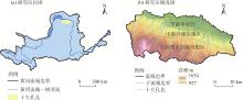
Fig. 1
Schematic diagram of the study area"
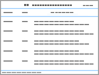
Tab. 1
Data information"
| 数据 | 数据来源 | 分辨率/m | 年份 |
|---|---|---|---|
| 归一化植被指数 | 美国国家航空航天局(MODIS 13Q数据)( | 250 | 2001—2022 |
| 年均降水量 | 国家青藏高原科学数据中心( | 1000 | 2001—2022 |
| 年均气温 | 国家青藏高原科学数据中心( | 1000 | 2001—2022 |
| 数字高程模型(DEM) | 地理空间数据云( | 30 | 2022 |
| 坡度 | 地理空间数据云( | 30 | 2022 |
| 土壤湿度 | 国家青藏高原科学数据中心( | 250 | 2022 |
| 土壤类型 | 国家青藏高原科学数据中心( | 250 | 2022 |
| 土地利用类型 | 美国地质勘探局官网( | 30 | 2001—2022 |
| 地区生产总值 | https://github.com/thestarlab/ChinaGDP | 1000 | 2014—2020 |
| 人口密度 | 美国能源部橡树岭国家实验室( | 1000 | 2001—2022 |
| 夜间灯光指数 | Harvard Dataverse( | 500 | 2001—2022 |
Tab. 2
Types of interaction detection and criteria for determination"
| 判据 | 交互作用 |
|---|---|
| 非线性减弱 | |
| 单因子非线性减弱 | |
| 双因子增强 | |
| 独立 | |
| 非线性增强 |
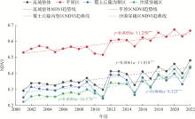
Fig. 2
NDVI trends and its ecological zones in the Ten Tributaries from 2001 to 2022"
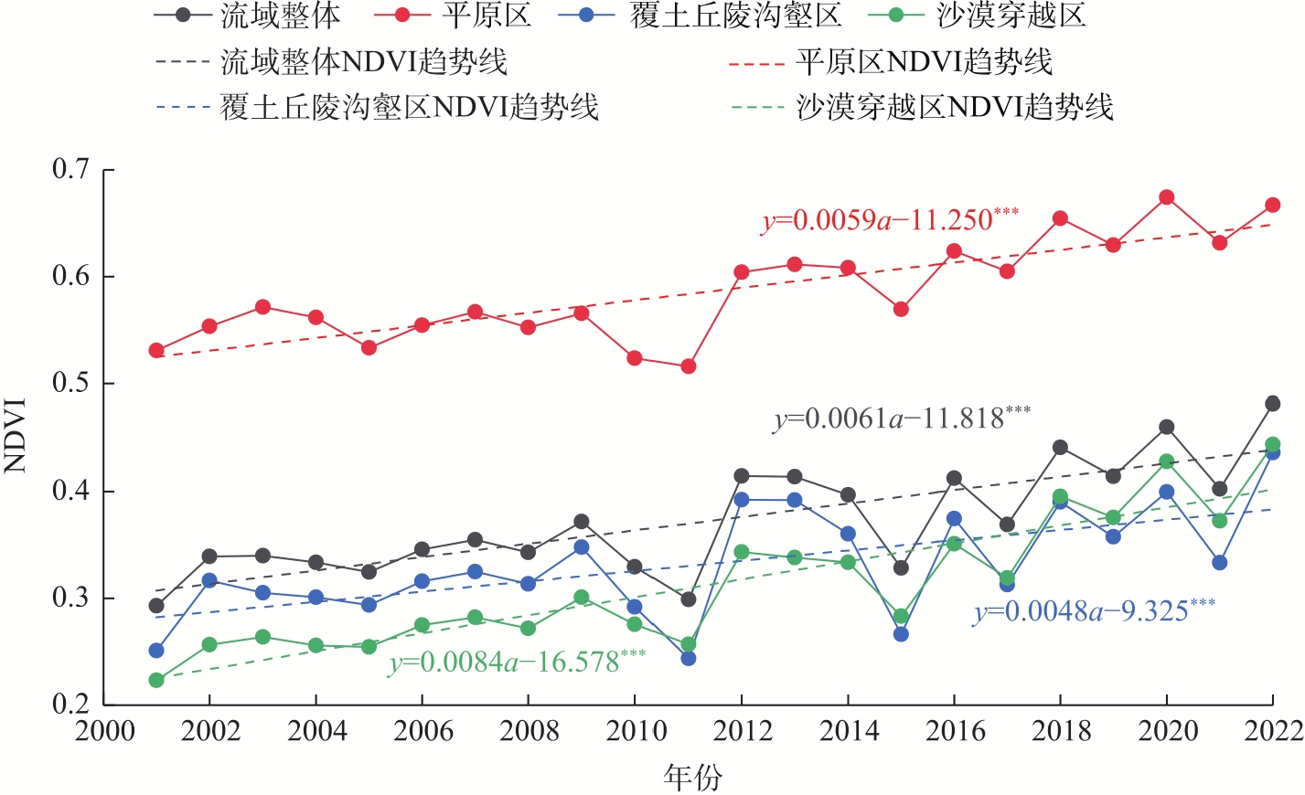
Fig. 3
Spatial distribution of NDVI from 2001 to 2022"
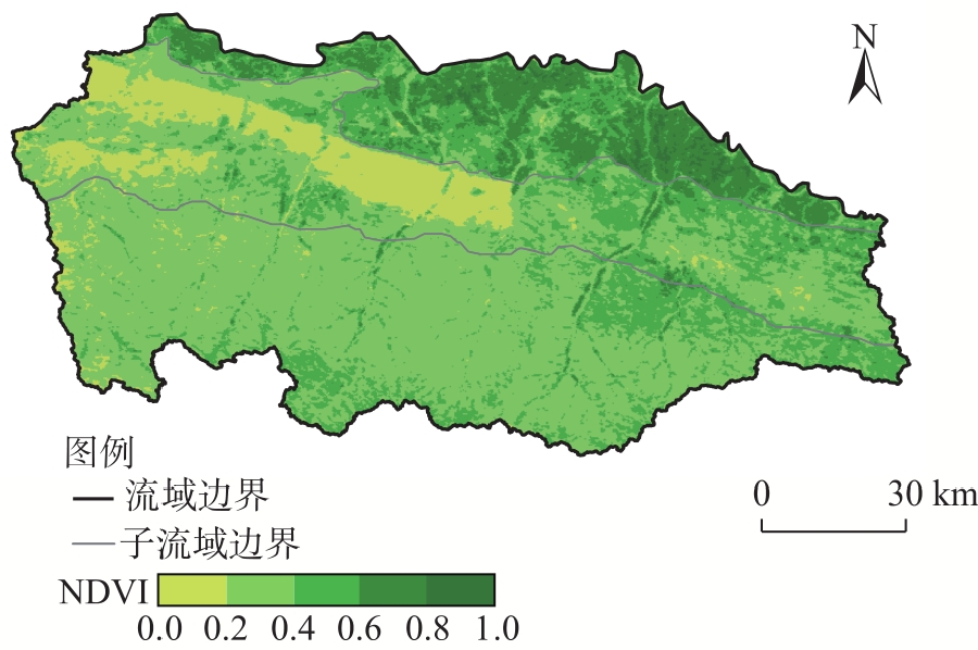
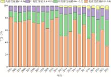
Fig. 4
Changes in different grades of vegetation coverage from 2001 to 2022"
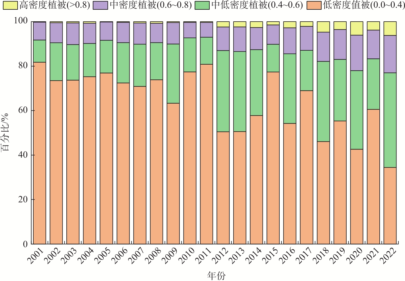
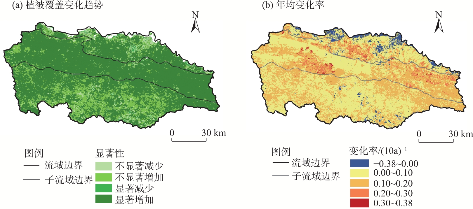
Fig. 5
Trends and annual mean change rate of vegetation cover in the Ten Tributaries region"
Tab. 3
Driving factors of NDVI change and their classification in the Ten Tributaries"
| 因子类型 | 驱动因子 | 代表符号 | 因子类型 | 驱动因子 | 代表符号 |
|---|---|---|---|---|---|
| 自然因子 | 年均降水量 | X1 | 自然因子 | 土壤类型 | X6 |
| 年均气温 | X2 | 人类活动因子 | 土地利用类型 | X7 | |
| DEM | X3 | 地区生产总值 | X8 | ||
| 坡度 | X4 | 人口密度 | X9 | ||
| 土壤湿度 | X5 | 夜间灯光指数 | X10 |
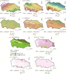
Fig. 6
Spatial distributions of driving factors in the Ten Tributaries region"

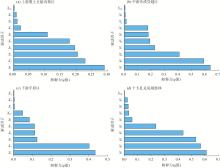
Fig. 7
Single factor detection results of different sub-areas and basins"
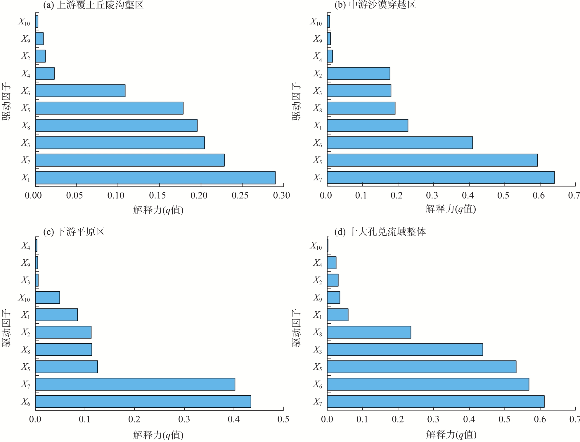
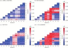
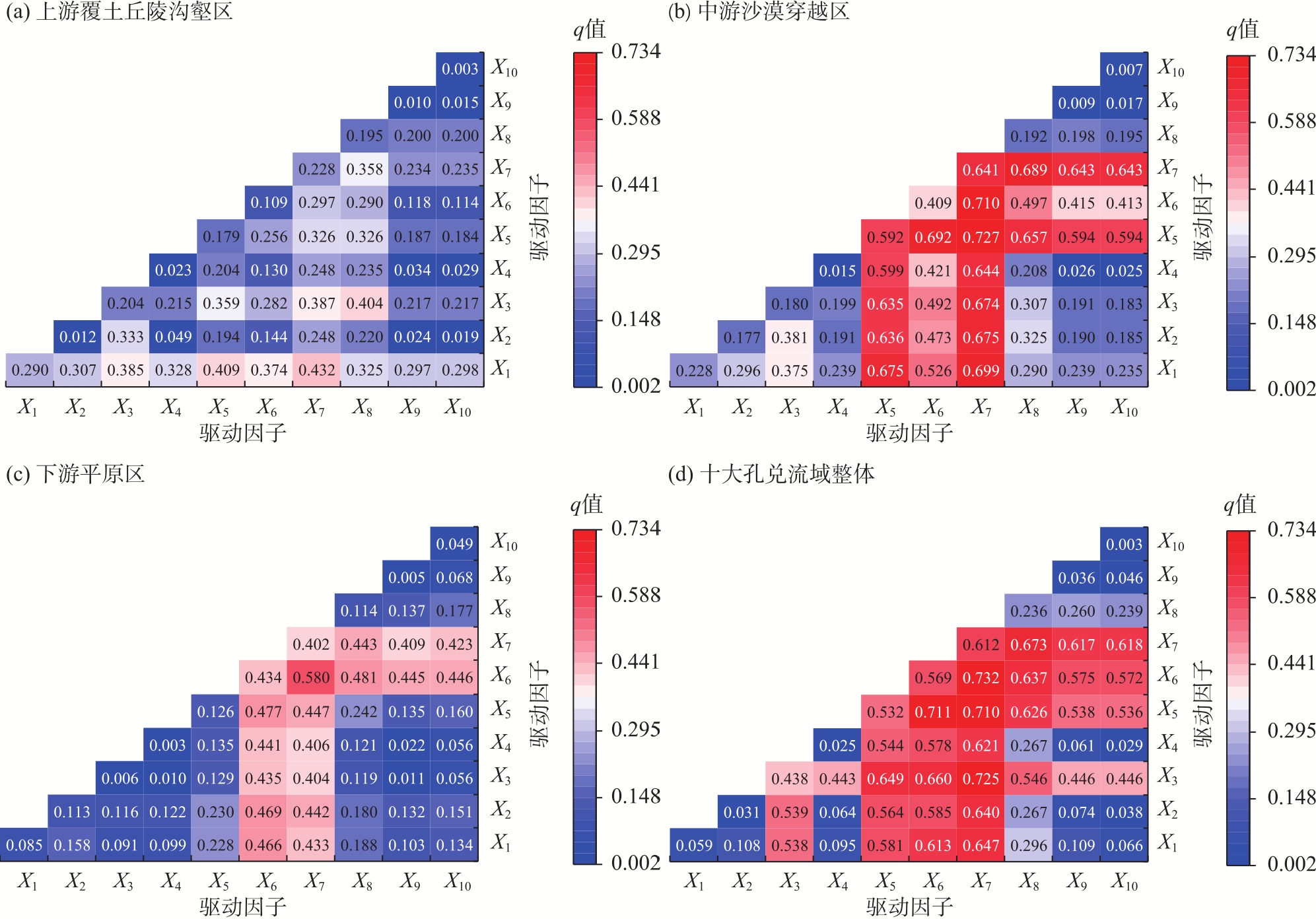
Fig. 8
Detection results of interaction factors in different sub-areas and basins"
| [1] | 许银, 袁江, 符素华. 黄土高原切沟汇水区植被恢复模式对土壤饱和导水率的影响及机制[J]. 水土保持学报, 2025, 39(5): 138-146. |
|
[Xu Yin, Yuan Jiang, Fu Suhua. Effects and mechanisms of vegetation restoration patterns on soil saturated hydraulic conductivity in gully catchment areas of Loess Plateau[J]. Journal of Soil and Water Conservation, 2025, 39(5): 138-146. ]
doi: 10.1080/00224561.1984.12436746 |
|
| [2] | 甄子雲, 赵洋, 姜群鸥, 等. 野外模拟降雨条件下高寒草甸区植被退化和人工植被恢复坡面的产流产沙过程[J]. 水土保持学报, 2024, 38(4): 153-161. |
| [Zhen Ziyun, Zhao Yang, Jiang Qunou, et al. Field simulation of runoff and sand production on degraded and revegetated slopes in alpine meadows under rainfall conditions[J]. Journal of Soil and Water Conservation, 2024, 38(4): 153-161. ] | |
| [3] | 银鹏. 2001-2020年中国干旱时空格局及其对植被的影响[D]. 兰州: 西北师范大学, 2024. |
| [Yin Peng. The spatiotemporal pattern of drought and its impact on vegetation in China from 2001 to 2020[D]. Lanzhou: Northwest Normal University, 2024. ] | |
| [4] | 谭阳涛. 2010-2020年乌江流域植被覆盖度时空演变及驱动机制分析[J]. 经纬天地, 2025(3): 1-4, 9. |
| [Tan Yangtao. Analysis for spatiotemporal evolution and driving mechanism of vegetation coverage in the Wujiang River Basin from 2010 to 2020[J]. Jingwei Tiandi, 2025(3): 1-4, 9. ] | |
| [5] | 王登辉, 符俊杰, 冯炼. 深圳市沿海红树林时空格局演变(1986-2021年)[J]. 华中师范大学学报(自然科学版), 2025, 59(5): 658-668. |
| [Wang Denghui, Fu Junjie, Feng Lian. Spatiotemporal dynamics of coastal mangroves in Shenzhen (1986-2021)[J]. Journal of Central China Normal University (Natural Sciences), 2025, 59(5): 658-668. ] | |
| [6] |
江慧娴, 董文杰. 气候变化和人类活动对华北地区植被NDVI的影响研究[J]. 高原气象, 2024, 43(5): 1312-1328.
doi: 10.7522/j.issn.1000-0534.2024.00013 |
|
[Jiang Huixian, Dong Wenjie. Impacts of climate change and human activities on NDVI change in north China[J]. Plateau Meteorology, 2024, 43(5): 1312-1328. ]
doi: 10.7522/j.issn.1000-0534.2024.00013 |
|
| [7] | 杨帆, 张亚军, 朱恕节, 等. 2000-2020年陕西省NDVI对气象和空气污染因素的空间响应[J]. 环境科学与技术, 2025, 48(11): 193-202. |
| [Yang Fan, Zhang Yajun, Zhu Shujie, et al. Spatial response of NDVI to meteorological and air pollution factors in Shaanxi Province from 2000 to 2020[J]. Environmental Science & Technology, 2025, 48(11): 193-202. ] | |
| [8] | 包磊, 吴勇, 张晓丽, 等. 云南4种松林地上碳储量空间分布及驱动因素分析[J/OL]. 西南林业大学学报(自然科学). [2025-10-09]. https://doi.org/10.11929/j.swfu.202503028. |
| [Bao Lei, Wu Yong, Zhang Xiaoli, et al. Spatial distribution and driving factors of aboveground carbon storage in four pine forests in Yunnan[J/OL]. Journal of Southwest Forestry University (Natural Sciences). [2025-10-09]. https://doi.org/10.11929/j.swfu.202503028.] | |
| [9] |
邹翔, 张雨婷, 徐璐. 2000-2022年呼伦贝尔植被覆盖时空动态及其对气候因子的响应[J]. 干旱区地理, 2025, 48(6): 963-972.
doi: 10.12118/j.issn.1000-6060.2024.456 |
|
[Zou Xiang, Zhang Yuting, Xu Lu. Spatio-temporal patterns of vegetation cover and its responses to climatic factors in Hulun Buir from 2000 to 2022[J]. Arid Land Geography, 2025, 48(6): 963-972. ]
doi: 10.12118/j.issn.1000-6060.2024.456 |
|
| [10] | 王瑞兵, 邹杰, 丁建丽, 等. 土壤水分是中亚干旱区植被生长的驱动力[J]. 生态学报, 2025, 45(9): 4294-4311. |
| [Wang Ruibing, Zou Jie, Ding Jianli, et al. Volumetric water content as the main driver of vegetation growth in the arid zone of Central Asia[J]. Acta Ecologica Sinica, 2025, 45(9): 4294-4311. ] | |
| [11] | 赖翀, 王小燕. 澜沧江流域植被变化与驱动因素的定量分析[J]. 水土保持通报, 2025, 45(4): 382-391. |
| [Lai Chong, Wang Xiaoyan. Quantitative analysis of vegetation change and driving factors in the Lancang River Basin[J]. Bulletin of Soil and Water Conservation, 2025, 45(4): 382-391. ] | |
| [12] | 颜亮, 王金枝, 张骁栋, 等. 草地生态系统植被变化的自然与人为因素定量区分方法[J]. 生态学报, 2022, 42(3): 1098-1107. |
| [Yan Liang, Wang Jinzhi, Zhang Xiaodong, et al. Methods for quantitatively assess the impacts of natural and anthropogenic factors on vegetation changes of grassland ecosystem[J]. Acta Ecologica Sinica, 2022, 42(3): 1098-1107. ] | |
| [13] | 李明月, 潘红忠, 陈鹏, 等. 长江上游NDVI变化及其对三峡水库入库水沙过程的影响[J]. 长江流域资源与环境, 2025, 34(12): 2829-2843. |
| [Li Mingyue, Pan Hongzhong, Chen Peng, et al. Changes of NDVI in the upper Yangtze River and influence on water-sand process in the Three Gorges Reservoir[J]. Resources and Environment in the Yangtze Basin, 2025, 34(12): 2829-2843. ] | |
| [14] | 宫航, 丁国栋, 刘昊, 等. 西藏地区2000-2022年植被覆盖度时空变化格局及驱动力分析[J/OL]. 环境科学. [2025-10-02]. https://doi.org/10.13227/j.hjkx.202505039. |
| [Gong Hang, Ding Guodong, Liu Hao, et al. Analysis of spatial and temporal variation pattern and driving force of vegetation coverage in Xizang region from 2000 to 2022[J/OL]. Environmental Science. [2025-10-02]. https://doi.org/10.13227/j.hjkx.202505039.] | |
| [15] | 马海岩, 朱江, 肖天贵. 安徽省植被NDVI变化特征及其对极端气候的响应[J/OL]. 三峡生态环境监测. [2025-07-25]. https://link.cnki.net/urlid/50.1214.X.20250619.1658.002. |
| [Ma Haiyan, Zhu Jiang, Xiao Tiangui. Characteristics of vegetation NDVI and its response to extreme climate in Anhui Province[J/OL]. Three Gorges Ecology and Environmental Monitoring. [2025-07-25]. https://link.cnki.net/urlid/50.1214.X.20250619.1658.002.] | |
| [16] |
陈珍, 蔡朝朝, 马楠, 等. 2001-2023年新疆NDVI时空格局与驱动力分析[J]. 干旱区研究, 2025, 42(5): 922-932.
doi: 10.13866/j.azr.2025.05.14 |
| [Chen Zhen, Cai Chaochao, Ma Nan, et al. Spatio-temporal patterns and driving forces of NDVI in Xinjiang from 2001 to 2023[J]. Arid Zone Research, 2025, 42(5): 922-932. ] | |
| [17] |
姜志伟, 杨智博, 杨清, 等. 2000-2022年库布齐沙漠植被覆盖度时空变化及其驱动因子[J]. 中国沙漠, 2025, 45(5): 124-133.
doi: 10.7522/j.issn.1000-694X.2025.00065 |
|
[Jiang Zhiwei, Yang Zhibo, Yang Qing, et al. Temporal and spatial variation of vegetation cover in Kubuqi Desert from 2000 to 2022 and its driving factors[J]. Journal of Desert Research, 2025, 45(5): 124-133. ]
doi: 10.7522/j.issn.1000-694X.2025.00065 |
|
| [18] |
马启民, 杜函芮, 王峥铭, 等. 鄂尔多斯高原十大孔兑不同地貌地形的植被覆盖特征分析[J]. 干旱区地理, 2025, 48(3): 434-443.
doi: 10.12118/j.issn.1000-6060.2024.241 |
|
[Ma Qimin, Du Hanrui, Wang Zhengming, et al. Vegetation coverage characteristics of different topography and landforms in Ten Tributaries of the Ordos Plateau[J]. Arid Land Geography, 2025, 48(3): 434-443. ]
doi: 10.12118/j.issn.1000-6060.2024.241 |
|
| [19] | 杨雨轩, 郭建英, 包雪源, 等. 十大孔兑风水复合侵蚀区土壤侵蚀机理与“以水定绿”型治理技术研究进展[J]. 内蒙古林业调查设计, 2023, 46(4): 73, 77-81. |
| [Yang Yuxuan, Guo Jianying, Bao Xueyuan, et al. Research progress on soil erosion mechanism and “greening by water” type control technology at Ten-Tributary Wind: Water compound erosion areas in Inner Mongolia[J]. Inner Mongolia Forestry Investigation and Design, 2023, 46(4): 73, 77-81. ] | |
| [20] | 孙宝洋, 李占斌, 张洋, 等. 黄河内蒙古支流“十大孔兑”区风蚀强度时空变化特征[J]. 农业工程学报, 2016, 32(17): 112-119. |
| [Sun Baoyang, Li Zhanbin, Zhang Yang, et al. Spatiotemporal variation of wind erosion intensity in region of Ten Small Tributaries in Inner Mongolia branch of Yellow River[J]. Transactions of the Chinese Society of Agricultural Engineering, 2016, 32(17): 112-119. ] | |
| [21] | 夏玉松, 周启刚, 李辉, 等. 基于决策树与NDVI时序变化检测的撂荒耕地的地形特征研究--以重庆市巫山县为例[J]. 水土保持通报, 2024, 44(4): 383-393. |
| [Xia Yusong, Zhou Qigang, Li Hui, et al. Topographic characteristics of abandoned farmland based on decision tree and NDVI time-series change detection: A case study of Wushan County, Chongqing[J]. Bulletin of Soil and Water Conservation, 2024, 44(4): 383-393. ] | |
| [22] |
花丛, 曹云, 王继康, 等. 2000-2023年浑善达克沙地春季沙尘天气分布特征及其与植被盖度、风况的关系[J]. 中国沙漠, 2024, 44(4): 71-80.
doi: 10.7522/j.issn.1000-694X.2024.00001 |
|
[Hua Cong, Cao Yun, Wang Jikang, et al. Spring sand-dust weather distribution in Hunshandak Sandy Land in relation to vegetation and wind in 2000-2023[J]. Journal of Desert Research, 2024, 44(4): 71-80. ]
doi: 10.7522/j.issn.1000-694X.2024.00001 |
|
| [23] | 陈梦华, 冯宇希, 李艳红. 气候变化与土地利用转型驱动下中国沿海地区植被NPP演变及其适应机制[J/OL]. 环境科学. [2025-07-25]. https://doi.org/10.13227/j.hjkx.202503290. |
| [Chen Menghua, Feng Yuxi, Li Yanhong. Spatiotemporal dynamics and adaptation mechanism in vegetation NPP in China’s coastal areas driven by climate change and land use transformation[J/OL]. Environmental Science. [2025-07-25]. https://doi.org/10.13227/j.hjkx.202503290.] | |
| [24] |
王劲峰, 徐成东. 地理探测器: 原理与展望[J]. 地理学报, 2017, 72(1): 116-134.
doi: 10.11821/dlxb201701010 |
|
[Wang Jinfeng, Xu Chengdong. Geodetector: Principle and prospect[J]. Acta Geographica Sinica, 2017, 72(1): 116-134. ]
doi: 10.11821/dlxb201701010 |
|
| [25] | Yang J, Wan Z Q, Borjigin S, et al. Changing trends of NDVI and their responses to climatic variation in different types of grassland in Inner Mongolia from 1982 to 2011[J]. Sustainability, 2019, 11(12): 3256, doi: 10.3390/su11123256. |
| [26] | Ren Z G, Tian Z G, Wei H T, et al. Spatiotemporal evolution and driving mechanisms of vegetation in the Yellow River Basin, China during 2000-2020[J]. Ecological Indicators, 2022, 138: 108832, doi: 10.1016/j.ecolind.2022.108832. |
| [27] |
Gong Z, Kawamura K, Ishikawa N, et al. MODIS normalized difference vegetation index (NDVI) and vegetation phenology dynamics in the Inner Mongolia grassland[J]. Solid Earth, 2015, 6(4): 1185-1194.
doi: 10.5194/se-6-1185-2015 |
| [28] | 高萌萌, 刘琼, 王轶, 等. 内蒙古西辽河平原植被指数时空变化及其影响因素研究[J]. 水文地质工程地质, 2022, 49(1): 175-182. |
| [Gao Mengmeng, Liu Qiong, Wang Yi, et al. Spatial and temporal variations in vegetation index and its impact factors in the West Liaohe Plain in Inner Mongolia[J]. Hydrogeology & Engineering Geology, 2022, 49(1): 175-182. ] | |
| [29] | 张祺祺. 十大孔兑地区降水径流转化与植被可用水量研究[D]. 杨凌: 西北农林科技大学, 2025. |
| [Zhang Qiqi. Conversion of precipitation to runoff and vegetation water availability in Ten Tributaries[D]. Yangling: Northwest A & F University, 2025. ] | |
| [30] | 张红武, 刘广全, 张宽地, 等. 十大孔兑复合侵蚀区泥沙阻控与近自然生态修复关键科学技术问题[J]. 人民黄河, 2024, 46(12): 1-10. |
| [Zhang Hongwu, Liu Guangquan, Zhang Kuandi, et al. Sediment control and near-natural ecological restoration in wind-water complex erosion area of the Top Ten Tributaries[J]. Yellow River, 2024, 46(12): 1-10. ] | |
| [31] | 张怡捷, 康宾, 张秀梅, 等. 内蒙古十大孔兑西柳沟流域土壤侵蚀及水土保持措施调查[J]. 水土保持通报, 2023, 43(6): 391-401. |
| [Zhang Yijie, Kang Bin, Zhang Xiumei, et al. Soil erosion and soil and water conservation measures at Xiliugou watershed in Ten Tributaries area in Inner Mongolia[J]. Bulletin of Soil and Water Conservation, 2023, 43(6): 391-401. ] | |
| [32] | 陈子彦, 王耀彬, 王尧, 等. 内蒙古草地植物物种丰富度时空格局及其驱动因素[J]. 水土保持研究, 2025, 32(5): 234-245. |
| [Chen Ziyan, Wang Yaobin, Wang Yao, et al. Spatiotemporal patterns and driving factors of plant species richness in Inner Mongolia grasslands[J]. Research of Soil and Water Conservation, 2025, 32(5): 234-245. ] |
|
||