Arid Land Geography ›› 2026, Vol. 49 ›› Issue (5): 975-986.doi: 10.12118/j.issn.1000-6060.2025.403
• Ecology and Environment • Previous Articles Next Articles
NING Xiaoju1( ), ZHANG Li2, YANG Luyao3, MAO Qizheng1(), LIU Xiaozhuo1
Received:2025-07-14
Revised:2025-08-18
Online:2026-05-25
Published:2026-05-25
Contact:
MAO Qizheng
E-mail:nxj0655@163.com;maoqizhenger@126.com
NING Xiaoju, ZHANG Li, YANG Luyao, MAO Qizheng, LIU Xiaozhuo. Spatiotemporal variations of livability level in the middle and lower reaches of the Yellow River under the impact of extreme climate[J].Arid Land Geography, 2026, 49(5): 975-986.

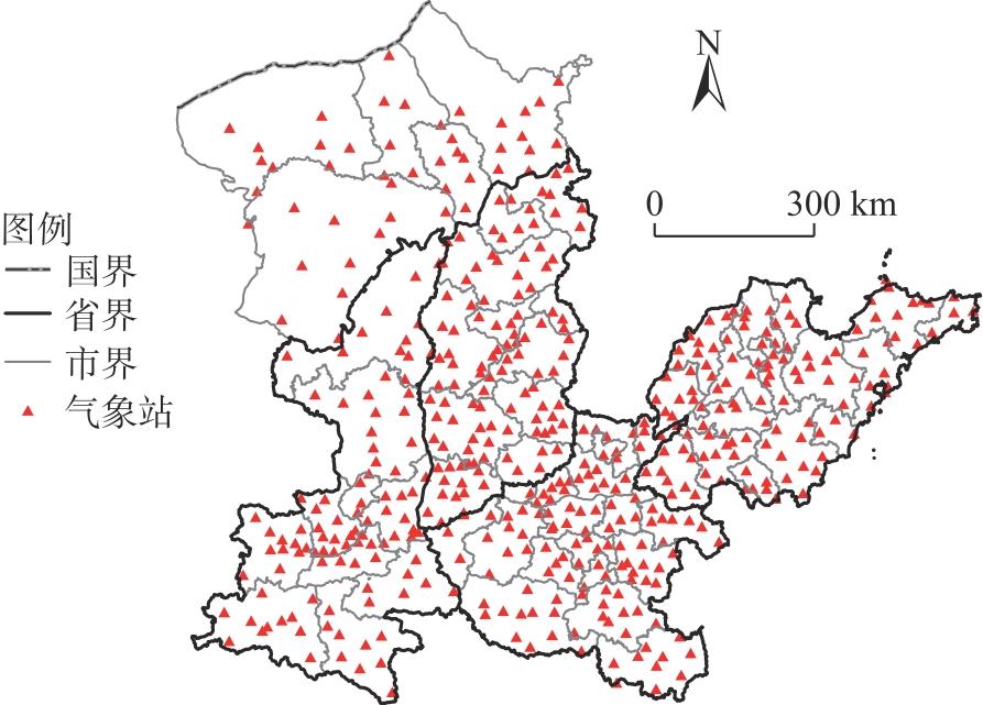
Fig. 1
Distribution of the meteorological stations in the study area"
Tab. 1
Indicators system for assessing the level of climate livable and simulating the impact of extreme climate on livability"
| 类别 | 类型 | 指标因子 | 含义 | 特征 |
|---|---|---|---|---|
| 气候宜居水平 | 年际水热适宜性 | 年平均气温/℃ | 一年中日平均气温的平均值 | 区间 |
| 年适宜温度天数/d | 一年中日平均气温在15~25 ℃的天数 | 正向 | ||
| 年适宜降水天数/d | 一年中日降水量在0.1~10 mm的天数 | 正向 | ||
| 年适宜湿度天数/d | 一年中日相对湿度在50%~80%的天数 | 正向 | ||
| 降水季节均匀度 | 冬季降水量与夏季降水量的比值 | 正向 | ||
| 夏季湿热适宜性 | 夏季平均气温日较差/℃ | 夏季日最高气温与日最低气温差值的平均值 | 正向 | |
| 夏季平均相对湿度/% | 夏季空气相对湿度的平均值 | 反向 | ||
| 7月平均最低气温/℃ | 7月日最低气温的平均值 | 区间 | ||
| 冬季光热适宜性 | 冬季日照总时数/h | 11、12月和次年1月日照时数的总和 | 正向 | |
| 1月平均最高气温/℃ | 1月日最高气温的平均值 | 正向 | ||
| 极端气候影响 | 极端高温 | 年高温天数/d | 一年中日最高气温≥35 ℃的天数 | 负向 |
| 年热浪天数/d | 一年中热浪事件的总天数 | 负向 | ||
| 年热浪频次/次 | 一年中热浪事件发生的总次数 | 负向 | ||
| 极端低温 | 年霜冻天数/d | 一年中日最低气温≤0 ℃的天数 | 负向 | |
| 年寒冷天数/d | 一年中风效指数<-400的天数 | 负向 | ||
| 极端降水 | 年极端降水量/mm | 一年中日降水量≥50 mm的降水量的和 | 负向 | |
| 年极端降水天数/d | 一年中日降水量≥50 mm的天数 | 负向 | ||
| 最大连续干日/d | 一年中最长一次持续无降水日数 | 负向 |
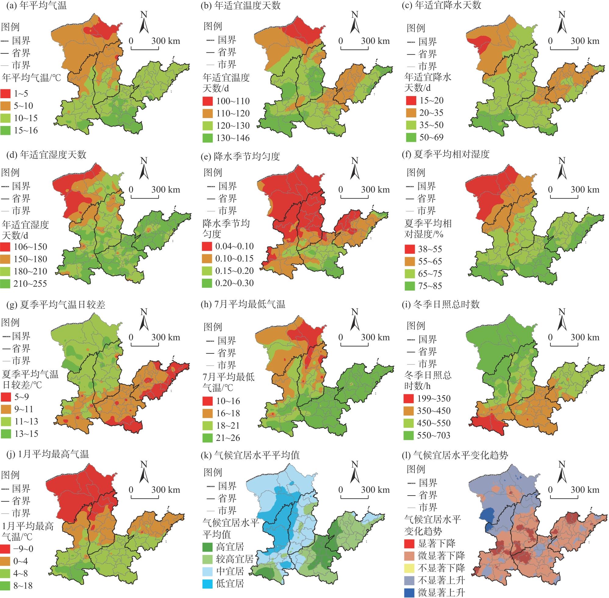
Fig. 2
Spatial distributions of climate suitability factors, average value and variation trend of climate livability levels in the middle and lower reaches of the Yellow River from 1990 to 2022"
Tab. 2
Statistics on the number and proportion of stations with varying trends in hydrothermal suitability factors"
| 变化趋势 | 显著性 | 年平均气温 | 年适宜温度天数 | 年适宜降水天数 | 年适宜湿度天数 | 降水季节均匀度 | |||||||||
|---|---|---|---|---|---|---|---|---|---|---|---|---|---|---|---|
| 站点数量 | 比例/% | 站点数量 | 比例/% | 站点数量 | 比例/% | 站点数量 | 比例/% | 站点数量 | 比例/% | ||||||
| 上升 | 显著 | 371 | 75.25 | 301 | 61.06 | 219 | 44.42 | 107 | 21.70 | 204 | 41.38 | ||||
| 不显著 | 69 | 14.00 | 139 | 28.19 | 160 | 32.45 | 79 | 16.03 | 133 | 26.98 | |||||
| 下降 | 显著 | 18 | 3.65 | 14 | 2.84 | 34 | 6.90 | 218 | 44.22 | 54 | 10.95 | ||||
| 不显著 | 35 | 7.10 | 39 | 7.91 | 80 | 16.23 | 89 | 18.05 | 102 | 20.69 | |||||
Tab. 3
Statistics on the number and proportion of stations with varying trends in summer heat-humidity and winter light-thermal suitability factors"
| 变化趋势 | 显著性 | 夏季平均相对湿度 | 夏季平均气温日较差 | 7月平均最低气温 | 冬季日照总时数 | 1月平均最高气温 | |||||||||
|---|---|---|---|---|---|---|---|---|---|---|---|---|---|---|---|
| 站点数量 | 比例/% | 站点数量 | 比例/% | 站点数量 | 比例/% | 站点数量 | 比例/% | 站点数量 | 比例/% | ||||||
| 上升 | 显著 | 48 | 9.74 | 102 | 20.69 | 324 | 65.72 | 34 | 6.90 | 135 | 27.38 | ||||
| 不显著 | 47 | 9.53 | 90 | 18.25 | 90 | 18.26 | 46 | 9.33 | 222 | 45.03 | |||||
| 下降 | 显著 | 309 | 62.68 | 200 | 40.57 | 31 | 6.28 | 342 | 69.37 | 16 | 3.25 | ||||
| 不显著 | 89 | 18.05 | 101 | 20.49 | 48 | 9.74 | 71 | 14.40 | 120 | 24.34 | |||||
Fig. 3
Spatial distributions of the impact intensity of extreme climate on livability"
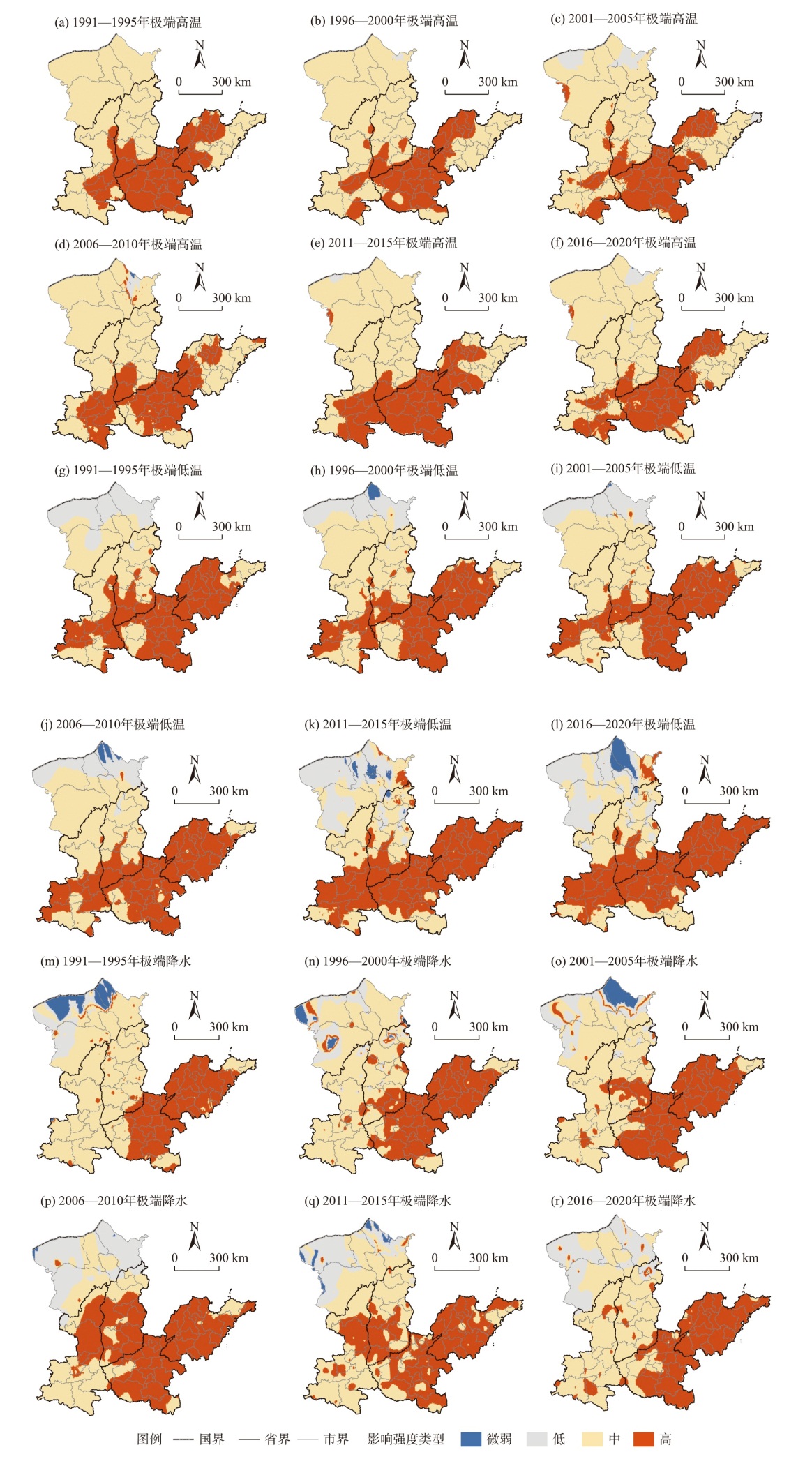
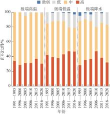
Fig. 4
Distribution of area proportions for various types of extreme climate on livability"

Fig. 5
Spatial distributions of high-impact types of extreme climate on livability"
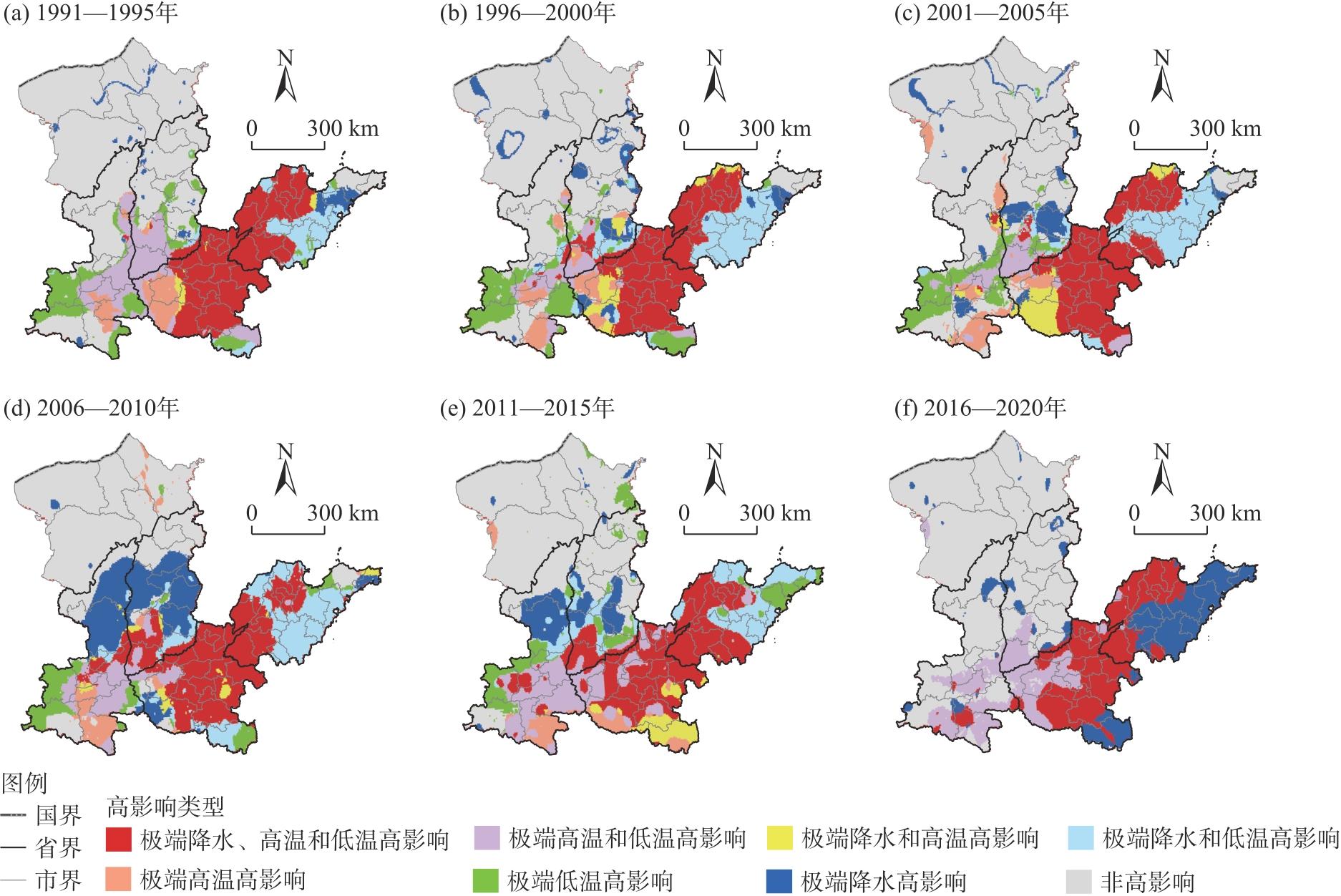
Tab. 4
Statistics on the area proportions of high-impact types of extreme climate on livability /%"
| 高影响类型 | 1991—1995年 | 1996—2000年 | 2001—2005年 | 2006—2010年 | 2011—2015年 | 2016—2020年 |
|---|---|---|---|---|---|---|
| 极端降水、高温 和低温高影响 | 20.30 | 18.60 | 18.73 | 20.79 | 20.31 | 18.40 |
| 极端高温和低温 高影响 | 9.32 | 3.65 | 4.12 | 5.71 | 10.16 | 12.00 |
| 极端降水和高温 高影响 | 0.61 | 2.39 | 3.77 | 1.41 | 2.75 | 0.00 |
| 极端降水和低温 高影响 | 5.15 | 9.19 | 8.93 | 11.19 | 8.80 | 0.00 |
| 极端高温高影响 | 3.78 | 3.95 | 4.53 | 3.20 | 3.36 | 0.00 |
| 极端低温高影响 | 7.22 | 7.89 | 5.93 | 5.31 | 7.37 | 0.00 |
| 极端降水高影响 | 2.22 | 4.91 | 5.23 | 13.70 | 6.28 | 13.61 |
| 非高影响 | 51.40 | 49.42 | 48.76 | 38.69 | 40.97 | 55.99 |
| [1] |
Wang Y J, Chen Y, Hewitt C, et al. Climate services for addressing climate change: Indication of a climate livable city in China[J]. Advances in Climate Change Research, 2021, 12(5): 744-751.
doi: 10.1016/j.accre.2021.07.006 |
| [2] | Vanos J, Guzman-Echavarria G, Baldwin J W, et al. A physiological approach for assessing human survivability and livability to heat in a changing climate[J]. Nature Communications, 2023, 14: 7653, doi: 10.1038/s41467-023-43121-5. |
| [3] | Chen W Z, Yi L, Wang J Y, et al. Evaluation of the livability of arid urban environments under global warming: A multi-parameter approach[J]. Sustainable Cities and Society, 2023, 99: 104931, doi: 10.1016/j.scs.2023.104931. |
| [4] | 刘圆, 王业成, 袁绮菲, 等. 南京江北核心区气候环境宜居水平评价[J]. 环境工程, 2017, 35(5): 145-148. |
| [Liu Yuan, Wang Yecheng, Yuan Qifei, et al. Assessment of climatic and environmental livability in core areas of Nanjing Jiangbei New District[J]. Environmental Engineering, 2017, 35(5): 145-148.] | |
| [5] | Zhang Y C, Xiao F, Mei H, et al. Comprehensive analysis of climate-related comfort in southern China: Climatology, trend, and interannual variations[J]. Urban Climate, 2022, 46: 101349, doi: 10.1016/j.uclim.2022.101349. |
| [6] |
贾妮娅·叶力肯, 侯建楠, 刘思博. 近30 a新疆地州市旅游气候舒适度时空特征分析[J]. 干旱区地理, 2025, 48(2): 212-222.
doi: 10.12118/j.issn.1000-6060.2024.086 |
|
[Yerken Jianiya, Hou Jiannan, Liu Sibo. Spatio-temporal characterization of tourism climate comfort in Xinjiang prefectures and cities in the last 30 years[J]. Arid Land Geography, 2025, 48(2): 212-222.]
doi: 10.12118/j.issn.1000-6060.2024.086 |
|
| [7] | Singh A, Chandra T, Mathur S, et al. Determination of outdoor thermal comfort thresholds for hot and semi-arid climates: A field study of residential neighborhoods in Jaipur City[J]. Sustainable Cities and Society, 2024, 115: 105817, doi: 10.1016/j.scs.2024.105817. |
| [8] |
Elsawy A A, Ayad H M, Saadallah D. Assessing livability of residential streets-case study: El-Attarin, Alexandria, Egypt[J]. Alexandria Engineering Journal, 2019, 58(2): 745-755.
doi: 10.1016/j.aej.2019.06.005 |
| [9] | 赵晓龙, 卞晴, 侯韫婧, 等. 寒地城市公园春季休闲体力活动水平与微气候热舒适关联研究[J]. 中国园林, 2019, 35(4): 80-85. |
| [Zhao Xiaolong, Bian Qing, Hou Yunjing, et al. A research on the correlation between physical activity performance and thermal comfortable of urban park in cold region[J]. Chinese Landscape Architecture, 2019, 35(4): 80-85.] | |
| [10] | Mostafa S, Kashi H, Farrokhzadeh S, et al. Effects of extreme weather events and climate change on cities’ livability[J]. Cities, 2024, 151: 105114, doi: 10.1016/j.cities.2024.105114. |
| [11] |
Filho W L, Tuladhar L, Li C L, et al. Climate change and extremes: Implications on city livability and associated health risks across the globe[J]. International Journal of Climate Change Strategies and Management, 2022, 15(1): 1-19.
doi: 10.1108/IJCCSM-07-2021-0078 |
| [12] | Alijani S, Pourahmad A, Nejad H H, et al. A new approach of urban livability in Tehran: Thermal comfort as a primitive indicator. Case study, district 22[J]. Urban Climate, 2020, 33: 100656, doi: 10.1016/j.uclim.2020.100656. |
| [13] | Shi C C, Guo N L, Zeng L L, et al. How climate change is going to affect urban livability in China[J]. Climate Services, 2022, 26: 100284, doi: 10.1016/j.cliser.2022.100284. |
| [14] |
王旭, 付学成, 徐文甜, 等. 2000—2020年中国城乡热舒适梯度特征及其驱动因素[J]. 地理学报, 2024, 79(5): 1318-1336.
doi: 10.11821/dlxb202405014 |
| [Wang Xu, Fu Xuecheng, Xu Wentian, et al. The signatures and drivers of thermal comfort acrossthe urban-rural gradient in Chinese citiesfrom 2000 to 2020[J]. Acat Geographica Scinica, 2024, 79(5): 1318-1336.] | |
| [15] |
贺山峰, 陈超冰, 李铮, 等. 黄河中上游极端降水特征及其对区域气候变化的敏感性[J]. 资源科学, 2024, 46(3): 524-537.
doi: 10.18402/resci.2024.03.07 |
|
[He Shanfeng, Chen Chaobing, Li Zheng, et al. Characteristics of extreme precipitation and its sensitivity to regional climate change in the upper and middle reaches of the Yellow River Basin[J]. Resources Science, 2024, 46(3): 524-537.]
doi: 10.18402/resci.2024.03.07 |
|
| [16] |
刘盼, 赵西宁, 高晓东, 等. 黄土高原极端气温变化特征及其与评价气温的相关性[J]. 应用生态学报, 2022, 33(7): 1975-1982.
doi: 10.13287/j.1001-9332.202207.024 |
|
[Liu Pan, Zhao Xining, Gao Xiaodong, et al. Characteristics of extreme temperature variation in the Loess Plateau and its correlation with average temperature[J]. Chinese Journal of Applied Ecology, 2022, 33(7): 1975-1982.]
doi: 10.13287/j.1001-9332.202207.024 |
|
| [17] |
Ghasemi K, Hamzenejad M, Meshkini A. The spatial analysis of the livability of 22 districts of Tehran metropolis using multi-criteria decision making approaches[J]. Sustainable Cities and Society, 2018, 38: 382-404.
doi: 10.1016/j.scs.2018.01.018 |
| [18] | Savari M, Moradi M. The effectiveness of drought adaptation strategies in explaining the livability of Iranian rural households[J]. Habitat International, 2022, 124: 102560, doi: 10.1016/j.habitatint.2022.102560. |
| [19] |
Xiao C, Wu P L, Zhang L X, et al. Robust increase in extreme summer rainfall intensity during the past four decades observed in China[J]. Scientific Reports, 2016, 6: 38506, doi: 10.1038/srep38506.
pmid: 27917927 |
| [20] | 于群, 孙越, 李建平, 等. 秋季黄河中下游降水主模态及2021年极端降水的气候背景[J]. 气象学报, 2023, 81(4): 547-558. |
| [Yu Qun, Sun Yue, Li Jianping, et al. The leading mode of autumn rainfall over the midlower reaches of the Yellow River and the climate background of extreme autumn rainfall in 2021[J]. Acta Meteorologica Sinica, 2023, 81(4): 547-558.] | |
| [21] |
黄晓军, 王博, 刘萌萌, 等. 中国城市高温特征及社会脆弱性评价[J]. 地理研究, 2020, 39(7): 1534-1547.
doi: 10.11821/dlyj020190608 |
| [Huang Xiaojun, Wang Bo, Liu Mengmeng, et al. Characteristics of urban extreme heat and assessment of social vulnerability in China[J]. Geographical Research, 2020, 39(7): 1534-1547.] | |
| [22] | Ma F, Yuan X, Li H. Characteristics and circulation patterns for wet and dry compound day-night heat waves in mid-eastern China[J]. Global and Planetary Change, 2022, 213: 103839, doi: 10.1016/j.gloplacha.2022.103839. |
| [23] | 王淼淼, 丁明虎, 吕俊梅, 等. 近40年中国冬季寒潮的气候特征及大气环流异常[J]. 应用气象学报, 2024, 35(3): 298-310. |
| [Wang Miaomiao, Ding Minghu, Lü Junmei, et al. Climatology of winter cold waves and associated atmospheric circulation anomalies in China during the last 40 years[J]. Journal of Applied Meteorological Science, 2024, 35(3): 298-310.] | |
| [24] | Lu Y F, Li J, Song Z Q, et al. Evaluating sustainable development in the middle and lower reaches of the Yellow River Basin using multiple data sources[J]. IEEE Transactions on Geoscience and Remote Sensing, 2025, 63: 1-18. |
| [25] | GB/T 42072-2022. 中华人民共和国国家标准: 气候宜居指数[S]. 北京: 中国标准出版社, 2022. |
| [GB/T 42072-2022. National standard of the People’s Republic of China: Climate livability index[S]. Beijing: Standards Press of China, 2022.] | |
| [26] | GB/T 27963-2011. 中华人民共和国国家标准: 人居环境舒适度评价[S]. 北京: 中国标准出版社, 2021. |
| [GB/T 27963-2011. National standard of the People’s Republic of China: Climatic suitability evaluating on human settlement[S]. Beijing: Standards Press of China, 2021.] | |
| [27] |
Phillips S J, Anderson R P, Schapire R E. Maximum entropy modeling of species geographic distributions[J]. Ecological Modelling, 2006, 190(3-4): 231-259.
doi: 10.1016/j.ecolmodel.2005.03.026 |
| [28] | IPCC Working Group II to the Fifth Assessment Report of the Intergouvermental Panel on Climate Change. Climate change 2014: Impacts, adaptation, and vulnerability[M]. Cambridge: Cambridge University Press, 2014: 1-696. |
| [29] |
安彬, 肖薇薇, 刘宇峰, 等. 1955—2021年黄土高原地区相对湿度时空演变规律[J]. 干旱区地理, 2023, 46(12): 1939-1950.
doi: 10.12118/j.issn.1000-6060.2023.105 |
|
[An Bin, Xiao Weiwei, Liu Yufeng, et al. Temporal and spatial evolution of relative humidity in the Loess Plateau during 1955—2021[J]. Arid Land Geography, 2023, 46(12): 1939-1950.]
doi: 10.12118/j.issn.1000-6060.2023.105 |
|
| [30] | 谭凯炎, 房世波, 俄有浩. 中国主要城市气候舒适度时空特征[J]. 气象与环境科学, 2024, 47(3): 1-7. |
| [Tan Kaiyan, Fang Shibo, E Youhao. Spatio-temporal features of climate comfortability in major cities of China[J]. Meteorological and Environmental Sciences, 2024, 47(3): 1-7.] | |
| [31] | 薛东前, 王莎, 王佳宁, 等. 黄土高原乡村“人水土”系统协同与机制[J]. 资源科学, 2022, 44(9): 1809-1823. |
|
[Xue Dongqian, Wang Sha, Wang Jianing, et al. Coordination of human-water-land system and mechanism in rural areas of the Loess Plateau[J]. Resources Science, 2022, 44(9): 1809-1823.]
doi: 10.18402/resci.2022.09.06 |
| [1] | CI Wang, DU Jun, ZHAXI Dunzhu, CHEN Xianyan, XIAO Zhuojing, PINGCUO Sangdan, LIU Sai. Climate response and operational impact of updated climatological normals in Xizang [J]. Arid Land Geography, 2026, 49(5): 907-916. |
| [2] | LI Ruonan, LI Junli, LIU Shuaiqi, DU Weibing. Glacier changes and topographic factors of the Ulugh Muztagh from 1960 to 2023 [J]. Arid Land Geography, 2026, 49(1): 23-34. |
| [3] | YAN Jinye, MA Zhengquan, SUN Xuanxuan, Alim ABBAS, Palida YAHEFU. Spatiotemporal variations and potential sources of PM2.5 and PM10 in the “Urumqi-Changji-Shihezi” urban agglomeration from 2015 to 2023 [J]. Arid Land Geography, 2025, 48(3): 405-420. |
| [4] | XIA Wenhao, WANG Mingyang, JIANG Lei. Spatiotemporal variation trends and convergence analysis of agricultural carbon emission intensity in Xinjiang [J]. Arid Land Geography, 2023, 46(7): 1145-1154. |
| [5] | LI Na,WU Yongli,ZHAO Guixiang,QIAN Jinxia,LI Fen,ZHAO Haiying,HAN Pu. Interannual variations of extreme air temperature events and its response to regional warming in Shanxi Province in recent 60 years [J]. Arid Land Geography, 2023, 46(3): 337-348. |
| [6] | YANG Wei-tao, SUN Jian-guo, KANG Yong-tai, MA Heng-li, XU Rui-ze. Temporal and spatial changes of extreme weather indices in the Loess Plateau [J]. Arid Land Geography, 2020, 43(6): 1456-1466. |
| [7] |
ZHAO Jian-ting, WANG Yan-jun, SU Bu-da, TAO Hui, JIANG Tong.
Spatiotemporal distributions of temperature,precipitation,evapotranspiration,and drought in the Indus River Basin [J]. Arid Land Geography, 2020, 43(2): 349-359. |
| [8] | ZHAO Feng, BI Shuoben, LI Xingyu, WU Weiting, JIANG Tingting. Spatial characteristics of drought/flood disasters based on EOF andREOF in the middle and lower reaches of the Yellow River [J]. Arid Land Geography, 2019, 42(4): 799-809. |
|
||