- Apr. 14, 2025
Arid Land Geography ›› 2024, Vol. 47 ›› Issue (1): 81-92.doi: 10.12118/j.issn.1000-6060.2023.263
• Earth Surface Process • Previous Articles Next Articles
PENG Ya1( ),WANG Juanjuan2,WANG Shanshan3,TIAN Liulan1,LIU Jie1,4,WU Zhaopeng1,4()
Received:2023-06-06
Revised:2023-07-22
Online:2024-01-25
Published:2024-01-26
PENG Ya, WANG Juanjuan, WANG Shanshan, TIAN Liulan, LIU Jie, WU Zhaopeng. Spatiotemporal pattern evolution of land use conflict in Urumqi City from the perspective of ecological security[J].Arid Land Geography, 2024, 47(1): 81-92.

Fig. 1
Schematic diagram of the study area"
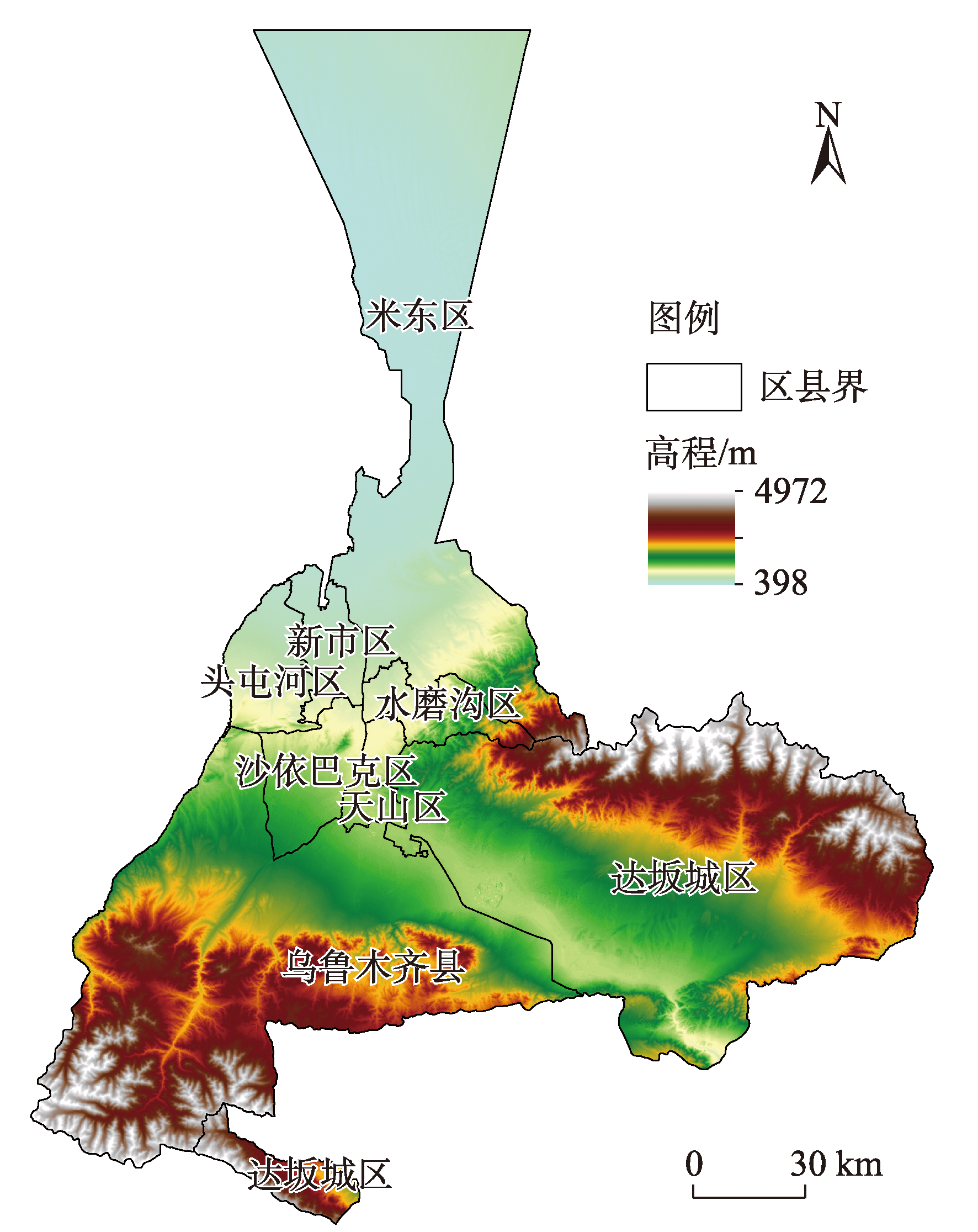

Fig. 2
Analytical framework"
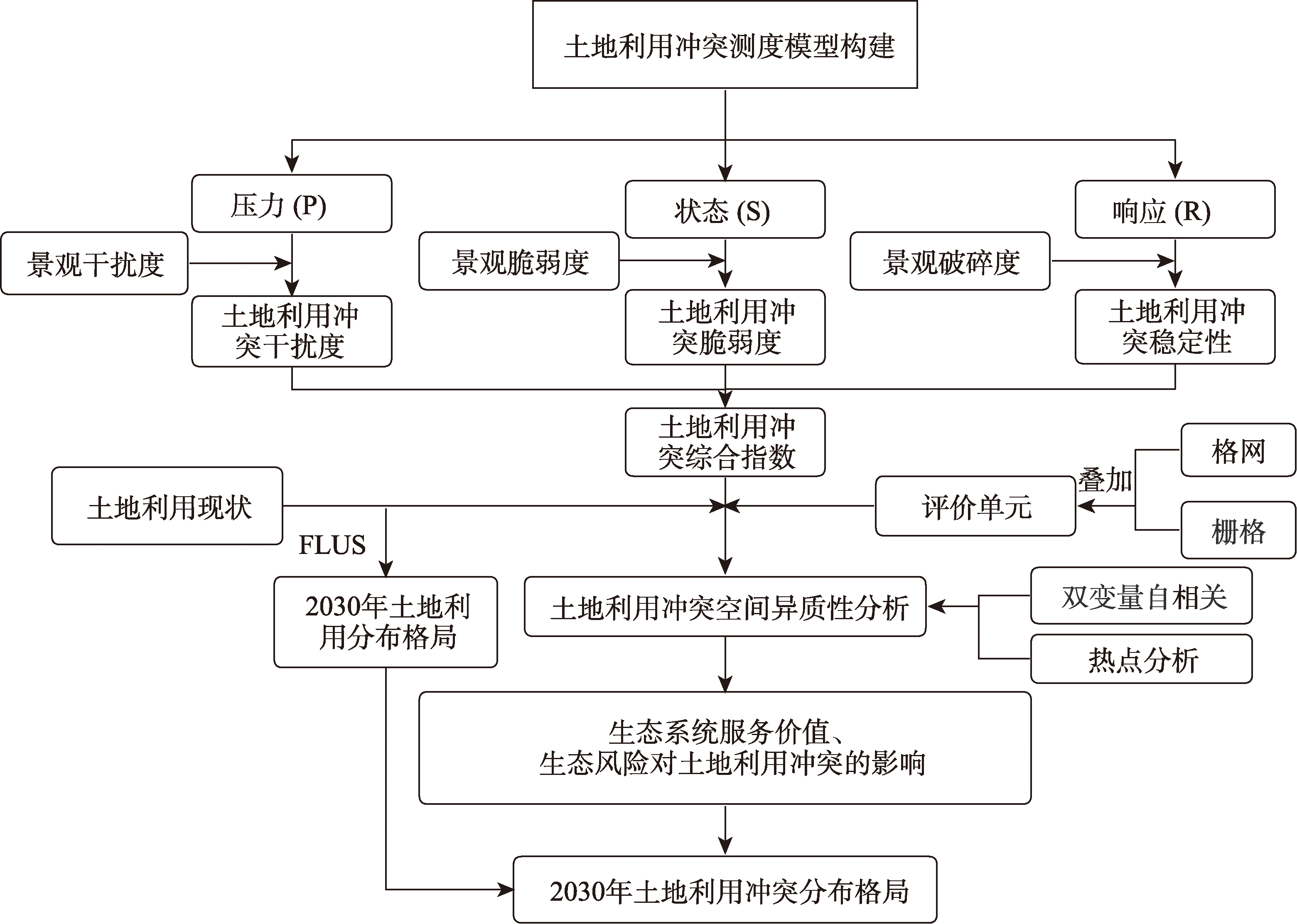

Fig. 3
Spatial distributions of natural factors"

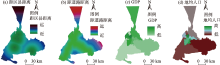
Fig. 4
Spatial distributions of social factors"

Tab. 1
Ecosystem service value coefficient per unit area of each land use type /104元·km-2"
| 一级类型 | 二级类型 | 耕地 | 林地 | 草地 | 水域 | 建设用地 | 未利用地 |
|---|---|---|---|---|---|---|---|
| 供给服务 | 食物生产 | 12.50 | 3.23 | 1.47 | 11.76 | 0.00 | 0.15 |
| 原料生产 | 5.88 | 7.65 | 2.06 | 3.38 | 0.00 | 0.44 | |
| 调节服务 | 水资源供给 | 0.29 | 3.97 | 1.18 | 121.88 | 0.00 | 0.29 |
| 气体调节 | 9.85 | 24.99 | 7.50 | 11.32 | 0.29 | 1.62 | |
| 气候调节 | 5.29 | 74.54 | 19.70 | 33.67 | 0.00 | 1.47 | |
| 净化环境 | 1.47 | 21.91 | 6.47 | 81.60 | 1.47 | 4.56 | |
| 水文调节 | 3.97 | 49.10 | 14.41 | 1503.13 | 0.44 | 3.09 | |
| 支持服务 | 土壤保持 | 15.14 | 30.29 | 9.12 | 13.67 | 0.29 | 1.91 |
| 维持养分循环 | 1.76 | 2.35 | 0.74 | 1.03 | 0.00 | 0.15 | |
| 生物多样性 | 1.91 | 27.64 | 8.23 | 37.49 | 0.29 | 1.76 | |
| 文化服务 | 美学景观 | 0.88 | 12.06 | 3.68 | 27.79 | 0.15 | 0.74 |
| 合计 | 58.96 | 257.73 | 74.54 | 1846.72 | 2.94 | 16.17 | |
Tab. 2
Kappa coefficient of land use conflict classification"
| 年份 | 无冲突 | 轻度冲突 | 中度冲突 | 高度冲突 | 重度冲突 |
|---|---|---|---|---|---|
| 2000 | 0.84 | 0.75 | 0.80 | 0.76 | 0.79 |
| 2010 | 0.87 | 0.80 | 0.78 | 0.79 | 0.76 |
| 2020 | 0.85 | 0.79 | 0.89 | 0.82 | 0.76 |
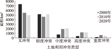
Fig. 5
Changes in the area of land use conflict types"
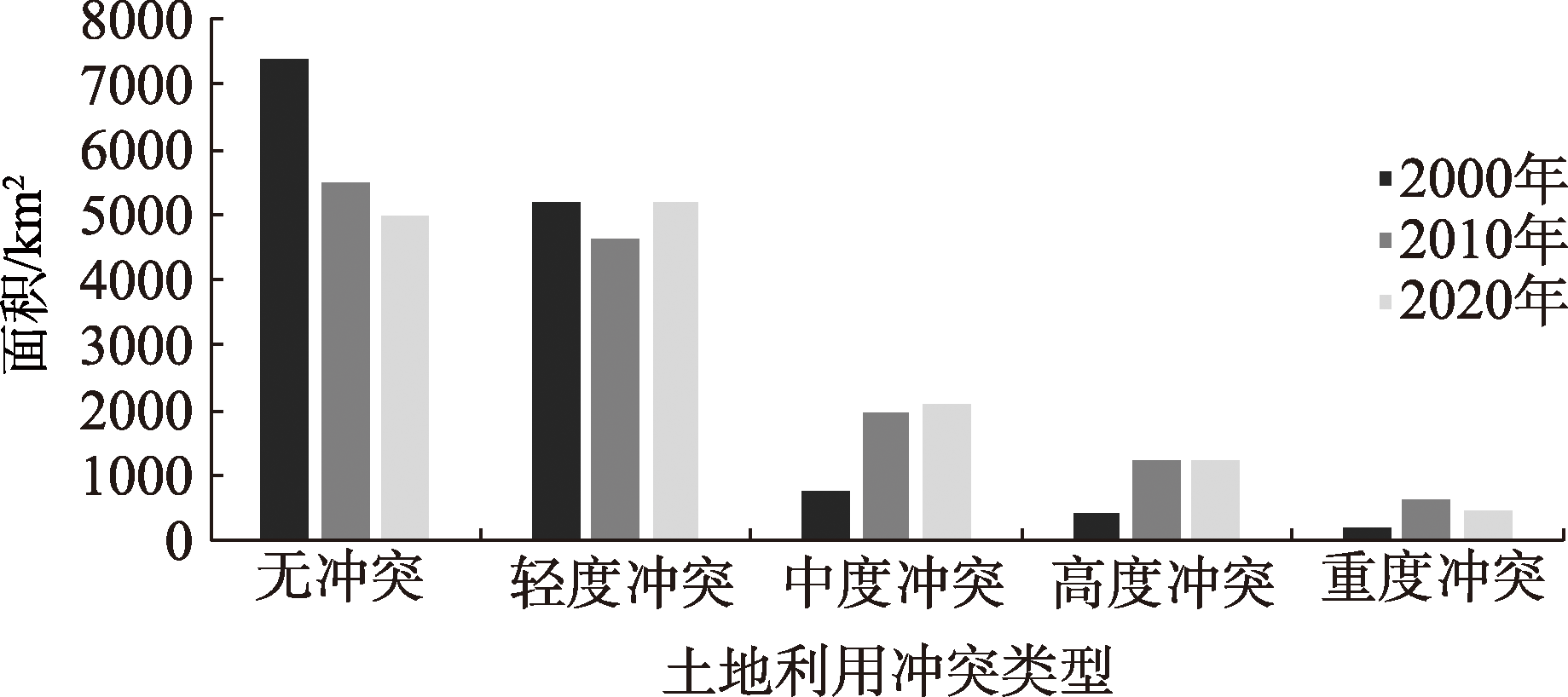

Fig. 6
Distribution pattern of land use conflict types"
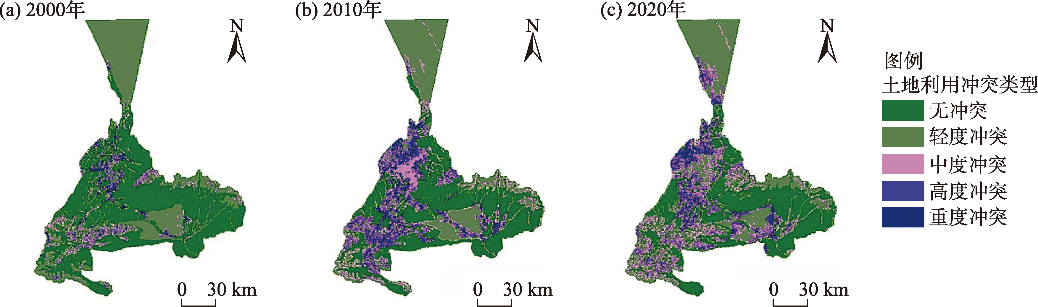
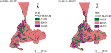
Fig. 7
Temporal and spatial evolution of cold and hot spots of land use conflict"

Tab. 3
Fitting model parameters of land use conflict variance functions"
| 年份 | 拟合模型 | 块金值(C0) | 基台值(C0+C) | C0/(C0+C) | 变程(A0) | 决定系数(R2) | 残差(RSS)/10-7 |
|---|---|---|---|---|---|---|---|
| 2000 | 指数 | 0.00107 | 0.00499 | 0.2144 | 18600 | 0.7970 | 6.5430 |
| 2010 | 高斯 | 0.00284 | 0.00672 | 0.4226 | 39000 | 0.9490 | 3.9990 |
| 2020 | 指数 | 0.00267 | 0.00546 | 0.4890 | 19900 | 0.9810 | 1.1400 |
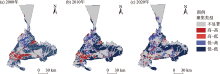
Fig. 8
Bivariate Lisa aggregation diagram of ecosystem service value and land use conflict"

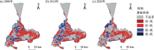
Fig. 9
Bivariate Lisa aggregation diagram of land use ecological risks and conflicts"
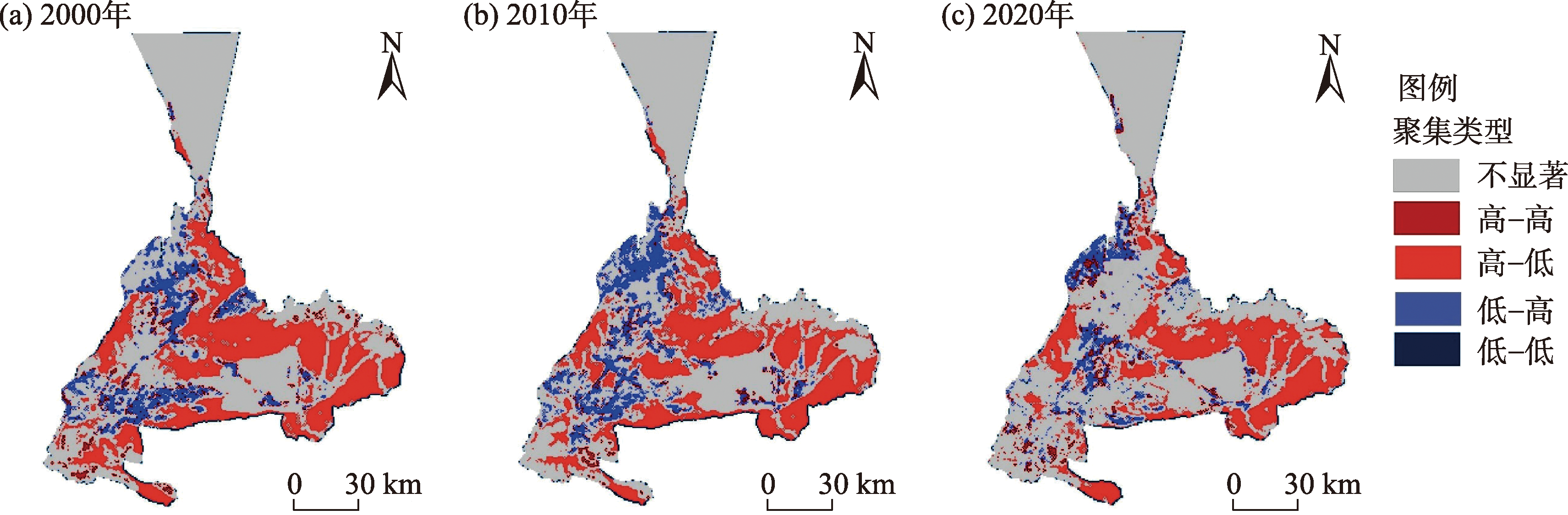
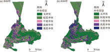
Fig. 10
Distribution of land use conflict pattern from 2020 to 2030"

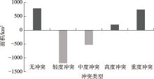
Fig. 11
Changes in land use conflicts from 2020 to 2030"
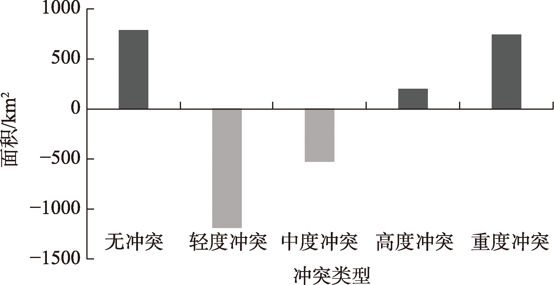
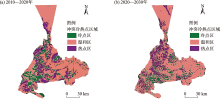
Fig. 12
Temporal and spatial evolution of cold and hot spots of land use conflics from 2010 to 2030"

| [1] | Zhao S D, Zhang Y M. Ecosystems and human well-being: The achievements, contributions and prospects of the millennium ecosystem assessment[J]. Advances in Earth Science, 2006, 21(9): 895-902. |
| [2] | Pacheco F. Sustainable use of soils and water: The role of environmental land use conflicts[J]. Sustainability, 2020, 12(3): 1163, doi: 10.3390/su12031163 |
| [3] | Fmpm A, Tm B. From conflict to conflicts: War-induced displacement, land conflicts, and agricultural productivity in post-war northern Uganda[J]. Land Use Policy, 2020, 101: 105149, doi: 10.1016/j.landusepol.2020.105149. |
| [4] |
Owens P L. Conflict as a social interaction process in environment and behaviour research: The example of leisure and recreation research[J]. Journal of Environmental Psychology, 1985, 5(3): 243-259.
doi: 10.1016/S0272-4944(85)80025-6 |
| [5] | Jiang S, Meng J, Zhu L. Spatial and temporal analyses of potential land use conflict under the constraints of water resources in the middle reaches of the Heihe River[J]. Land Use Policy, 2020, 97: 104-773. |
| [6] | Cendrero A. Land-use problems, planning and management in the coastal zone: An introduction[J]. Ocean & Shoreline Management, 1989, 12(5-6): 367-381. |
| [7] |
Groot D. Function-analysis and valuation as a tool to assess land use conflicts in planning for sustainable, multi-functional landscapes[J]. Landscape Urban Plan, 2006, 75(3-4): 175-186.
doi: 10.1016/j.landurbplan.2005.02.016 |
| [8] |
Tudor C A, Iojă I C, Pǎtru-Stupariu I, et al. How successful is the resolution of land-use conflicts? A comparison of cases from Switzerland and Romania[J]. Applied Geography, 2014, 47(1): 125-136.
doi: 10.1016/j.apgeog.2013.12.008 |
| [9] | Ruth S D F, Jonathan A F, Gregory P A. Land-use choices: Balancing human needs and ecosystem function[J]. The Ecological Society of America, 2004, 2(5): 249-257. |
| [10] | 于伯华, 吕昌河. 土地利用冲突分析: 概念与方法[J]. 地理科学进展, 2006, 25(3): 106-115. |
| [Yu Bohua, Lü Changhe. The progress and prospect of land use conflicts[J]. Progress in Geographical Sciences, 2006, 25(3): 106-115.] | |
| [11] |
Campbell D J, Gichohi H, Mwangi A, et al. Land use conflict in Kajiado District, Kenya[J]. Land Use Policy, 2000, 17(4): 337-348.
doi: 10.1016/S0264-8377(00)00038-7 |
| [12] | 陈文慧, 刘庆, 朱红梅, 等. 快速城市化进程中土地利用冲突时空演化特征与模拟预测——以长株潭城市群为例[J]. 江苏农业科学, 2017, 45(9): 286-291. |
| [Chen Wenhui, Liu Qing, Zhu Hongmei, et al. Spatial-temporal evolution characteristics and simulation prediction of land use conflict in the process of rapid urbanization: A case study of Changsha Zhuzhou Xiangtan urban agglomeration[J]. Jiangsu Agricultural Sciences, 2017, 45(9): 286-291.] | |
| [13] | Xiao D N, Chen W B, Guo F L. On the basic concepts and contents of ecological security[J]. Chinese Journal of Applied Ecology, 2002, 13(3): 354-358. |
| [14] | 常宇茜. 生态安全视角下河南镇平县土地利用冲突识别与分区调控研究[D]. 北京: 中国地质大学, 2022. |
| [Chang Yuxi. Research on land use conflict identification and zoning regulation in Zhenping County, Henan Province from the perspective of ecological security[D]. Beijing: China University of Geosciences, 2022.] | |
| [15] | 杨永芳, 朱连奇. 土地利用冲突的理论与诊断方法[J]. 资源科学, 2012, 34(6): 1134-1141. |
| [Yang Yongfang, Zhu Lianqi. The theory and diagnostic methods of land use conflicts[J]. Resource Science, 2012, 34(6): 1134-1141.] | |
| [16] | Hammond A, Adriaanse A, Rodenburg E, et al. Environmental in dicators: A systematic approach to measuring and reporting on environmental policy performance in the context of sustainable development[M]. Washington D C: World Resource Institute, 1995. |
| [17] |
彭佳捷, 周国华, 唐承丽, 等. 基于生态安全的快速城市化地区空间冲突测度——以长株潭城市群为例[J]. 自然资源学报, 2012, 27(9): 1507-1519.
doi: 10.11849/zrzyxb.2012.09.008 |
|
[Peng Jiajie, Zhou Guohua, Tang Chengli, et al. The analysis of spatial conflict measurement in fast urbanization region based on ecological security: A case study of Changsha Zhuzhou Xiangtan urban agglomeration[J]. Journal of Natural Resources, 2012, 27(9): 1507-1519.]
doi: 10.11849/zrzyxb.2012.09.008 |
|
| [18] | 吴金华, 刘思雨, 白帅. 基于景观生态安全的神木市生态廊道识别与优化[J]. 干旱区研究, 2021, 38(4): 1120-1127. |
| [Wu Jinhua, Liu Siyu, Bai Shuai. Identification and optimization of ecological corridors in Shenmu City based on landscape ecological security[J]. Arid Zone Research, 2021, 38(4): 1120-1127.] | |
| [19] |
冯长春, 曹敏政, 谢婷婷. 不同生态保育尺度下铜陵市土地利用结构优化[J]. 地理研究, 2014, 33(12): 2217-2227.
doi: 10.11821/dlyj201412001 |
|
[Feng Changchun, Cao Minzheng, Xie Tingting. Optimization of land use structure in Tongling City based on different ecological conservation scales[J]. Geography Research, 2014, 33(12): 2217-2227.]
doi: 10.11821/dlyj201412001 |
|
| [20] | 杨晓辉. 城市土地再开发过程中的利益冲突与规划调控策略研究[D]. 苏州: 苏州科技学院, 2014. |
| [Yang Xiaohui. The strategy analysis of profit conflict and planning regulation in the progress of redevelopment of urban land[D]. Suzhou: Suzhou University of Science and Technology, 2014.] | |
| [21] | 徐馨裔, 刘志有, 董露, 等. 国土空间规划视角下产业结构与土地利用结构相互关系研究——以新疆乌鲁木齐市为例[J]. 生态经济, 2020, 36(4): 69-74. |
| [Xu Xinyi, Liu Zhiyou, Dong Lu, et al. Research on the mutual relationship between industrial structure and land utilization structure from the perspective of national land space planning: Taking Urumqi of Xinjiang as an example[J]. Ecological Economy, 2020, 36(4): 69-74.] | |
| [22] | Ma W, Jiang G, Chen Y, et al. How feasible is regional integration for reconciling land use conflicts across the urban-rural interface? Evidence from Beijing-Tianjin-Hebei metropolitan region in China[J]. Land Use Policy, 2020, 92, doi: 10.1016/j.landusepol.2019.104433. |
| [23] |
Adger W N. Vulnerability[J]. Global Environmental Change, 2006, 16(3): 268-281.
doi: 10.1016/j.gloenvcha.2006.02.006 |
| [24] | 蔡运龙, 李军. 土地利用可持续性的度量——一种显示过程的综合方法[J]. 地理学报, 2003, 58(2): 305-313. |
| [Cai Yunlong, Li Jun. Measurement of land use sustainability: A comprehensive method representing processes[J]. Acta Geography Sinca, 2003, 58(2): 305-313.] | |
| [25] |
裴彬, 潘韬. 土地利用系统动态变化模拟研究进展[J]. 地理科学进展, 2010, 29(9): 1060-1066.
doi: 10.11820/dlkxjz.2010.09.006 |
|
[Pei Bin, Pan Tao. Land use system dynamic modeling: Literature review and future research direction in China[J]. Progress in Geography, 2010, 29(9): 1060-1066.]
doi: 10.11820/dlkxjz.2010.09.006 |
|
| [26] | 周子鑫, 朱传耿. 我国区域空间整合研究进展与展望[J]. 地域研究与开发, 2009, 28(5): 1-5. |
| [Zhou Zixin, Zhu Chuangeng. Recent progress of studies on the regional spatial integration and its prospects in China[J]. Areal Research and Development, 2009, 28(5): 1-5.] | |
| [27] | Qian Y, Xing W, Guan X, et al. Coupling cellular automata with area partitioning and spatiotemporal convolution for dynamic land use change simulation[J]. Science of the Total Environment, 2020, 722: 137738, doi: 10.1016/j.scitotenv.2020.137738. |
| [28] | 谢高地, 张彩霞, 张雷明, 等. 基于单位面积价值当量因子的生态系统服务价值化方法改进[J]. 自然资源学报, 2015, 30(8): 1243-1254. |
| [Xie Gaodi, Zhang Caixia, Zhang Leiming, et al. Improvement of the evaluation method for ecosystem service value based on per unit area[J]. Journal of Natural Resource, 2015, 30(8): 1243-1254.] | |
| [29] | 谢高地, 张彩霞, 张昌顺, 等. 中国生态系统服务的价值[J]. 资源科学, 2015, 37(9): 1740-1746. |
| [Xie Gaodi, Zhang Caixia, Zhang Changshun, et al. The value of ecosystem services in China[J]. Resource Science, 2015, 37(9): 1740-1746.] | |
| [30] |
O’Neill R V, Hunsaker C T, Timmins S P, et al. Scale problems in reporting landscape pattern at the regional scale[J]. Landscape Ecology, 1996, 11: 169-180.
doi: 10.1007/BF02447515 |
| [31] | 王玲. 基于土地利用变化的上海市生态风险评价[J]. 农业科学研究, 2018, 39(1): 10-16. |
| [Wang Ling. Ecological risk assessment based on land use change in Shanghai City[J]. Journal of Agricultural Sciences, 2018, 39(1): 10-16.] | |
| [32] |
巩杰, 赵彩霞, 谢余初, 等. 基于景观格局的甘肃白龙江流域生态风险评价与管理[J]. 应用生态学报, 2014, 25(7): 2041-2048.
pmid: 25345056 |
|
[Gong Jie, Zhao Caixia, Xie Yuchu, et al. Ecological risk assessment and its management of Bailongjiang watershed, southern Gansu based on landscape pattern[J]. Chinese Journal of Applied Ecology, 2014, 25(7): 2041-2048.]
pmid: 25345056 |
|
| [33] | 肖琳, 田光进. 天津市土地利用生态风险评价[J]. 生态学杂志, 2014, 33(2): 469-476. |
| [Xiao Lin, Tian Guangjin. Eco-risk assessment of land use in Tianjin City[J]. Chinese Journal of Ecology, 2014, 33(2): 469-476.] | |
| [34] | 田苗, 王鹏新, 严泰来, 等. Kappa系数的修正及在干旱预测精度及一致性评价中的应用[J]. 农业工程学报, 2012, 28(24): 1-7. |
| [Tian Miao, Wang Pengxin, Yan Tailai, et al. Adjustment of Kappa coefficient and its application in precision and agreement evaluation of drought forecasting models[J]. Transactions of the Chinese Society of Agricultural Engineering, 2012, 28(24): 1-7.] | |
| [35] | 王国杰, 廖善刚. 土地利用强度变化的空间异质性研究[J]. 应用生态学报, 2006, 17(4): 4611-4614. |
| [Wang Guojie, Liao Shangang. Spatial heterogeneity of land use intensity[J]. Chinese Journal of Applied Ecology, 2006, 17(4): 4611-4614.] | |
| [36] | 唐宏, 乔旭宁, 杨德刚, 等. 土地利用变化时空特征与区域发展关系研究——以渭干河流域为例[J]. 干旱地区农业研究, 2012, 30(3): 205-213. |
| [Tang Hong, Qiao Xuning, Yang Degang, et al. Characteristics of temporal and spatial dynamic changes of land use and their relationship with regional development: Case study in the Weigan River Basin[J]. Agricultural Research the Arid Areas, 2012, 30(3): 205-213.] | |
| [37] | 田柳兰, 王珊珊, 毋兆鹏. 基于多时相遥感数据的乌鲁木齐市生态安全格局构建[J]. 干旱区地理, 2023, 46(7): 1155-1165. |
| [Tian Liulan, Wang Shanshan, Wu Zhaopeng. Construction of ecological security pattern in Urumqi based on multi-temporal remote sensing data[J]. Arid Land Geography, 2023, 46(7): 1155-1165.] | |
| [38] | 王珊珊, 毋兆鹏. 基于生态安全的乌鲁木齐市土地利用冲突识别[J]. 湖北农业科学, 2022, 61(1): 46-53. |
| [Wang Shanshan, Wu Zhaopeng. Identification of land use conflicts based on ecological security in Urumqi City[J]. Hubei Agricultural Science, 2022, 61(1): 46-53.] |
| Viewed | ||||||||||||||||||||||||||||||||||||||||||||||||||
|
Full text 75
|
|
|||||||||||||||||||||||||||||||||||||||||||||||||
|
Abstract 149
|
|
|||||||||||||||||||||||||||||||||||||||||||||||||
Cited |
|
|||||||||||||||||||||||||||||||||||||||||||||||||
| Shared | ||||||||||||||||||||||||||||||||||||||||||||||||||
|
||