- May. 11, 2025
Arid Land Geography ›› 2022, Vol. 45 ›› Issue (2): 379-388.doi: 10.12118/j.issn.1000–6060.2021.214
• Climatology and Hydrology • Previous Articles Next Articles
LI Anbei1,2( ),WAN Yu1,ZHANG Jun1,LI Ruqi1(),Mangsuer AIRETI1,LI Na1
Received:2021-05-08
Revised:2021-06-15
Online:2022-03-25
Published:2022-04-02
Contact:
Ruqi LI
E-mail:634200781@qq.com;liruqi@sohu.com
LI Anbei,WAN Yu,ZHANG Jun,LI Ruqi,Mangsuer AIRETI,LI Na. Circulation classification and cause analysis of the snowstorm case in Urumqi City from 1961 to 2019[J].Arid Land Geography, 2022, 45(2): 379-388.

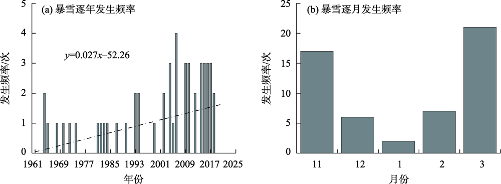
Fig. 1
Annual and monthly frequency of snowstorm in Urumqi City from 1961 to 2019"
Tab. 1
Statistics of various types of snowstorm in Urumqi City from 1961 to 2019"
| 环流类型 | 总次数/次 | 逐月发生次数/次 | 典型个例日期(年-月-日) | ||||
|---|---|---|---|---|---|---|---|
| 11月 | 12月 | 1月 | 2月 | 3月 | |||
| 槽前西南气流型(Ⅰ型) | 16 | 4 | 4 | 2 | 3 | 3 | 2013-11-20,2014-12-08 2015-12-11,2018-12-01 |
| 低槽(涡)东移型(Ⅱ型) | 17 | 6 | 1 | 0 | 1 | 9 | 2015-02-13,2016-11-05 2017-12-28,2018-03-18 |
| 强锋区型(Ⅲ型) | 20 | 7 | 1 | 0 | 3 | 9 | 2004-03-26,2006-03-30 2010-03-21,2017-02-20 |

Fig. 2
500 hPa average geopotential height field of 4 cases of snowstorm with southwest airflow in front of trough in Urumqi City"


Fig. 3
Vertical structure and water vapor transportation of the snowstorm area"

Fig. 4
500 hPa average geopotential height field of 4 cases of snowstorm with trough (vortex) eastward in Urumqi City"


Fig. 5
Vertical structure and water vapor transportation of the snowstorm area"
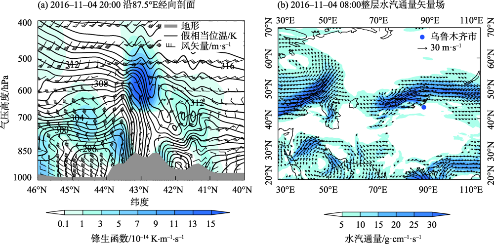

Fig. 6
500 hPa average geopotential height field of 4 cases of snowstorm with strong front area in Urumqi City"


Fig. 7
Vertical structure and water vapor transportation of the snowstorm area"

| [1] | 章诞武, 丛振涛, 倪广恒. 1956—2010年中国降雪特征变化[J]. 清华大学学报(自然科学版), 2016, 56(4):381-386, 393. |
| [ Zhang Danwu, Cong Zhentao, Ni Guangheng. Snowfall changes in China during 1956—2010[J]. Journal of Tsinghua University (Science and Technology), 2016, 56(4):381-386, 393. ] | |
| [2] | 孙秀忠, 罗勇, 张霞, 等. 近46年来我国降雪变化特征分析[J]. 高原气象, 2010, 29(6):1594-1601. |
| [ Sun Xiuzhong, Luo Yong, Zhang Xia, et al. Analysis on snowfall change characteristic of China in recent 46 years[J]. Plateau Meteorology, 2010, 29(6):1594-1601. ] | |
| [3] | 陈海山, 罗江珊, 韩方红. 中国北方暴雪的年代际变化及其与大气环流和北极海冰的联系[J]. 大气科学学报, 2019, 42(1):68-77. |
| [ Chen Haishan, Luo Jiangshan, Han Fanghong. Interdecadal variation of heavy snowfall in northern China and its linkages with atmospheric circulation and Arctic sea ice[J]. Transactions of Atmospheric Sciences, 2019, 42(1):68-77. ] | |
| [4] | 王遵娅, 周波涛. 影响中国北方强降雪事件年际变化的典型环流背景和水汽收支特征分析[J]. 地球物理学报, 2018, 61(7):2654-2666. |
| [ Wang Zunya, Zhou Botao. Large-scale atmospheric circulations and water vapor transport influencing interannual variations of intense snowfalls in northern China[J]. Chinese Journal of Geophysics, 2018, 61(7):2654-2666. ] | |
| [5] | 付亮. 影响东北的北上温带气旋暴雪的统计特征和典型个例研究[D]. 南京: 南京信息工程大学, 2019. |
| [ Fu Liang. Statistical characteristics and a case study of snowstorms associated with northward extratropical cyclones in northeast China[D]. Nanjing: Nanjing University of Information Science and Technology, 2019. ] | |
| [6] |
陈长胜, 王盘兴, 杨秀峰, 等. 东北地区暴雪天气的统计学划分方法及其时空分布特征[J]. 地理科学, 2012, 32(10):1275-1281.
doi: 10.13249/j.cnki.sgs.2012.010.1275 |
|
[ Chen Changsheng, Wang Panxing, Yang Xiufeng, et al. Classification and features of spatio-temporal variation of snowstorms in northeast China[J]. Science Geographic Sinica, 2012, 32(10):1275-1281. ]
doi: 10.13249/j.cnki.sgs.2012.010.1275 |
|
| [7] | 周晓宇, 赵春雨, 崔妍, 等. 1961—2017年中国东北地区降雪时空演变特征分析[J]. 冰川冻土, 2020, 42(3):766-779. |
| [ Zhou Xiaoyu, Zhao Chunyu, Cui Yan, et al. Analyzing the characteristics of temporal and spatial evolution of snowfall in northeast China from 1961 to 2017[J]. Journal of Glaciology and Geocryology, 2020, 42(3):766-779. ] | |
| [8] | 高松影, 赵婷婷, 宋丽丽, 等. 辽宁省冬季区域暴雪水汽输送特征[J]. 冰川冻土, 2020, 42(2):439-446. |
| [ Gao Songying, Zhao Tingting, Song Lili, et al. Transporting characteristics of snowstorm water vapor over Liaoning Province in winter[J]. Journal of Glaciology and Geocryology, 2020, 42(2):439-446. ] | |
| [9] | 阎琦, 崔锦, 杨青. 2018年辽宁两次雨转暴雪过程对比分析[J]. 干旱气象, 2019, 37(6):944-953. |
| [ Yan Qi, Cui Jin, Yang Qing. Comparative analysis of two rain to snowstorm processes in Liaoning in 2018[J]. Journal of Arid Meteorology, 2019, 37(6):944-953. ] | |
| [10] | 李津, 赵思雄, 孙建华. 一次华北破纪录暴雪成因的分析研究[J]. 气候与环境研究, 2017, 22(6):683-698. |
| [ Li Jin, Zhao Sixiong, Sun Jianhua. Analysis of a record heavy snowfall event in north China[J]. Climate and Environmental Research, 2017, 22(6):683-698. ] | |
| [11] | 胡玲, 刘锦, 东高红, 等. 天津城区暴雪的环流形势与雷达特征分析[J]. 气象与环境科学, 2020, 43(1):34-42. |
| [ Hu Ling, Liu Jin, Dong Gaohong, et al. Analysis on the circulation situation and radar characteristics of snowstorm in Tianjin City[J]. Meteorological and Environmental Sciences, 2020, 43(1):34-42. ] | |
| [12] | 王丛梅, 李永占, 刘晓灵. 河北省南部回流暴雪天气结构特征[J]. 气象与环境学报, 2015, 31(3):23-28. |
| [ Wang Congmei, Li Yongzhan, Liu Xiaoling. Structural feature of return-flow snowstorm in southern Hebei Province[J]. Journal of Meteorology and Environment, 2015, 31(3):23-28. ] | |
| [13] |
陈雪珍, 慕建利, 赵桂香, 等. 华北暴雪过程中的急流特征分析[J]. 高原气象, 2014, 33(4):1069-1075.
doi: 10.7522/j.issn.1000-0534.2013.00205 |
|
[ Chen Xuezhen, Mu Jianli, Zhao Guixiang, et al. Analysis of jet stream characteristic during the snowstorm in north China[J]. Plateau Meteorology, 2014, 33(4):1069-1075. ]
doi: 10.7522/j.issn.1000-0534.2013.00205 |
|
| [14] |
张俊兰, 崔彩霞, 陈春艳. 北疆典型暴雪天气的水汽特征研究[J]. 高原气象, 2013, 32(4):1115-1125.
doi: 10.7522/j.issn.1000-0534.2012.00105 |
|
[ Zhang Junlan, Cui Caixia, Chen Chunyan. Study on water vapor characteristics of typical heavy snowstorm case in northern Xinjiang[J]. Plateau Meteorology, 2013, 32(4):1115-1125. ]
doi: 10.7522/j.issn.1000-0534.2012.00105 |
|
| [15] | 王勇, 赵战成, 晏军, 等. 新疆雪灾的时空分布特征及其等级划分[J]. 干旱区地理, 2020, 43(3):577-583. |
| [ Wang Yong, Zhao Zhancheng, Yan Jun, et al. Spatial and temporal distribution characteristics and its classification of snow disaster in Xinjiang[J]. Arid Land Geography, 2020, 43(3):577-583. ] | |
| [16] | 田亚林, 李雪梅, 李珍, 等. 1980—2017年天山山区不同降水形态的时空变化[J]. 干旱区地理, 2020, 43(2):308-318. |
| [ Tian Yalin, Li Xuemei, Li Zhen, et al. Spatial and temporal variations of different precipitation types in the Tianshan Mountains from 1980 to 2017[J]. Arid Land Geography, 2020, 43(2):308-318. ] | |
| [17] | 庄晓翠, 李博渊, 李如琦, 等. 新疆北部强降雪天气研究若干进展[J]. 沙漠与绿洲气象, 2016, 10(1):1-8. |
| [ Zhuang Xiaocui, Li Boyuan, Li Ruqi, et al. Some advances on study of strong snowfall in northern Xinjiang[J]. Desert and Oasis Meteorology, 2016, 10(1):1-8. ] | |
| [18] | 杨莲梅, 杨涛, 贾丽红, 等. 新疆大~暴雪气候特征及其水汽分析[J]. 冰川冻土, 2005, 27(3):389-396. |
| [ Yang Lianmei, Yang Tao, Jia Lihong, et al. Analysis of the climate characteristics and water vapor of heavy snow in Xinjiang Region[J]. Journal of Glaciology and Geocryology, 2005, 27(3):389-396. ] | |
| [19] | 万瑜, 窦新英. 新疆中天山一次城市暴雪过程诊断分析[J]. 气象与环境学报, 2013, 29(6):8-14. |
| [ Wan Yu, Dou Xinying. Diagnostic analysis of an urban snowstorm process in the middle of Tianshan Mountains of Xinjiang[J]. Journal of Meteorology and Environment, 2013, 29(6):8-14. ] | |
| [20] | 张俊兰, 万瑜, 闵月. 乌鲁木齐“2015·12·11”极端暴雪天气的综合分析[J]. 沙漠与绿洲气象, 2017, 11(1):1-10. |
| [ Zhang Junlan, Wan Yu, Min Yue. Comprehensive analysis of an extreme blizzard in Urumqi on December 11th, 2015[J]. Desert and Oasis Meteorology, 2017, 11(1):1-10. ] | |
| [21] | 庄晓翠, 李健丽, 李博渊, 等. 天山北坡2次暴雪过程机理分析[J]. 沙漠与绿洲气象, 2019, 13(1):29-38. |
| [ Zhuang Xiaocui, Li Jianli, Li Boyuan, et al. Mechanism analysis of two class blizzard process in the north slope of Tianshan Mountains[J]. Desert and Oasis Meteorology, 2019, 13(1):29-38. ] | |
| [22] | 牟欢, 赵丽, 孙硕阳, 等. 天山北麓两次暴雪天气对比分析[J]. 干旱区地理, 2019, 42(6):1262-1272. |
| [ Mu Huan, Zhao Li, Sun Shuoyang, et al. Comparative analysis of two blizzard weather mechanisms in the northern piedmonts of Tianshan Mountains[J]. Arid Land Geography, 2019, 42(6):1262-1272. ] | |
| [23] | 肖开提·多莱特. 新疆降水量级标准的划分[J]. 沙漠与绿洲气象, 2005, 28(3):7-8. |
| [ Duolaite Xiaokaiti. Classification of precipitation magnitude standard in Xinjiang[J]. Desert and Oasis Meteorology, 2005, 28(3):7-8. ] |
| [1] | HONG Chunhua, LI Xiaohu. Assessing the spatial equity of urban educational resources under the background of population changes: A case study of the main urban area of Urumqi City [J]. Arid Land Geography, 2024, 47(8): 1411-1419. |
| [2] | LIN Qiuping, LI Songrui, YANG Shangguang, WANG Yunyun. Spatiotemporal evolution, influencing factors, and development strategies of logistics enterprise location in Urumqi City [J]. Arid Land Geography, 2024, 47(7): 1252-1262. |
| [3] | TANG Yuting, DU Hongru. Spatial scope of community living circle and comprehensive measurement method of construction level: Urumqi City as an example [J]. Arid Land Geography, 2024, 47(2): 332-342. |
| [4] | PENG Ya, WANG Juanjuan, WANG Shanshan, TIAN Liulan, LIU Jie, WU Zhaopeng. Spatiotemporal pattern evolution of land use conflict in Urumqi City from the perspective of ecological security [J]. Arid Land Geography, 2024, 47(1): 81-92. |
| [5] | TIAN Liulan, WANG Shanshan, WU Zhaopeng. Construction of ecological security pattern in Urumqi based on multi-temporal remote sensing data [J]. Arid Land Geography, 2023, 46(7): 1155-1165. |
| [6] | QU Lianglu, YAO Junqiang, ZHAO Yong, ZHOU Xueyan. Mechanism and causes of a local extreme snowstorm at the northern edge of the Tarim Basin [J]. Arid Land Geography, 2023, 46(5): 719-729. |
| [7] | LIANG Liang, GUO Xiaosong, CHEN Hanjie, XU Haofan, ZHOU Yanbo, XIE Shaowen, YANG Fen, WEI Chaoyang. Accumulation characteristics and ecological risks of heavy metals in green land soils in core urban area of Urumqi City [J]. Arid Land Geography, 2023, 46(11): 1868-1878. |
| [8] | SUI Lu, PU Chunling, LIU Zhiyou, BAI Pengfei, LIU Tao. Trade-off synergy of ecosystem service value in Urumqi City based on PLUS model [J]. Arid Land Geography, 2023, 46(1): 159-168. |
| [9] | WEI Juanjuan,LI Na,WAN Yu,Mangsuer AIRETI,SHI Junjie. Mechanisms and causes of typical snowstorms in Urumqi [J]. Arid Land Geography, 2022, 45(5): 1381-1391. |
| [10] | LI Haihua,MIN Yue,LI Anbei,LI Ruqi. Comparative analysis of on water vapor characteristics of two extreme rainstorms in the north slope of Kunlun Mountains [J]. Arid Land Geography, 2022, 45(3): 715-724. |
| [11] | YANG Tao,YANG Lianmei,ZHOU Hongkui,YU Xingjie,LI Yuanpeng. Hourly snowfall characteristics and influence system of heavy snowstorm in northern Xinjiang [J]. Arid Land Geography, 2022, 45(3): 725-733. |
| [12] | SHI Junjie,SUN Mingjing,LYU Xinsheng,ZHANG Junlan,LI Huoqing. Comprehensively analysis of an extreme snowstorm in the west of southern Xinjiang in spring [J]. Arid Land Geography, 2022, 45(1): 131-140. |
| [13] | ZHAO Keming,LI Na,LI Xia,SUN Mingjing,SHI Junjie,AN Dawei,PU Jie,ZHENG Bohua. Characteristic analysis of atmospheric diffusion conditions of winter foehn weather process in Urumqi City [J]. Arid Land Geography, 2021, 44(6): 1534-1544. |
| [14] | ZHAO Yongyu,Alimujiang KASIM,GAO Pengwen,LIANG Hongwu. Quantitative analysis of urban expansion and response factors in Urumqi City based on random forest algorithm and geographical detector [J]. Arid Land Geography, 2021, 44(6): 1729-1739. |
| [15] | MIAO Yunling,GONG Hengrui,WANG Jian,GE Yicheng,LI Ruqi. Diurnal variation characteristics of summer precipitation in Urumqi Cityfrom 2012 to 2019 [J]. Arid Land Geography, 2021, 44(5): 1222-1230. |
| Viewed | ||||||||||||||||||||||||||||||||||||||||||||||||||
|
Full text 636
|
|
|||||||||||||||||||||||||||||||||||||||||||||||||
|
Abstract 529
|
|
|||||||||||||||||||||||||||||||||||||||||||||||||
Cited |
|
|||||||||||||||||||||||||||||||||||||||||||||||||
| Shared | ||||||||||||||||||||||||||||||||||||||||||||||||||
|
||