Arid Land Geography ›› 2022, Vol. 45 ›› Issue (5): 1637-1648.doi: 10.12118/j.issn.1000-6060.2022.033
• Regional Development • Previous Articles Next Articles
CHENG Jing1( ),WANG Peng2,CHEN Hongxiang1(),HAN Yonggui1
Received:2022-01-25
Revised:2022-03-29
Online:2022-09-25
Published:2022-10-20
Contact:
Hongxiang CHEN
E-mail:958830559@qq.com;670577976@qq.com
CHENG Jing,WANG Peng,CHEN Hongxiang,HAN Yonggui. Geographical exploration of the spatial and temporal evolution of ecological risk and its influencing factors in semi-arid regions: A case of Yanchi County in Ningxia[J].Arid Land Geography, 2022, 45(5): 1637-1648.
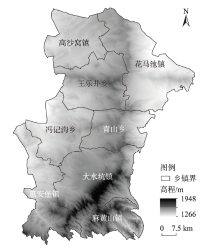
Fig. 1
Geographical location of the study area"
Tab. 1
Calculation methods of landscape pattern indices"
| 景观格局指数 | 计算公式 | 含义 |
|---|---|---|
| 斑块数 (NP) | NP=ni | 式中:ni为景观i的斑块数;NP反映了区域景观或不同景观类型的空间分布格局及其破碎化程度。 |
| 斑块密度 (PD) | | 式中:Ai为景观i的总面积(km2);A为景观总面积(km2);PD描述区域景观或不同景观类型空间斑块的破碎程度。 |
| 最大斑块指数 (LPI) | | 式中:Amax为最大斑块的面积(km2);A为景观总面积(km2);LPI反映了区域景观中的优势景观类型及其丰富程度,体现了人类活动的强弱程度。 |
| 景观形状指数 (LSI) | | 式中:E为研究区景观斑块边界的总长度(km);A为景观总面积(km2);LSI反映了区域景观或不同景观类型的斑块形状结构的复杂性特征。 |
| 景观分离度指数 (SPLIT) | | 式中:A为景观总面积(km2);Ai为景观i的总面积(km2);n为斑块数;SPLIT描述不同景观类型斑块的破碎化程度,从而间接地反映了人类干扰的强度对斑块的影响程度。 |
| 蔓延度指数(CONTAG) | | 式中:m为景观类型数;n为斑块数;pij为随机选择的2个邻近栅格单元是属于i和j的概率;CONTAG描述了区域景观的空间团聚程度及其延展的趋势。 |
| 香浓多样性指数(SHDI) | | 式中:pi为景观i所占景观总面积的比例(%);n为景观类型数;SHDI反映了区域景观类型的丰度及其景观多样性特征的变化情况。 |
Tab. 2
Calculation formulas of ecological risk indices"
| 生态风险指数 | 计算公式 | 含义 |
|---|---|---|
| 景观破碎度 (Ci) | | 式中:Ci为景观i的破碎度;ni为景观i的斑块数;Ai为景观i的总面积(km2)。Ci表示景观的破碎化程度,该值越大,说明生态系统稳定性越差。 |
| 景观分离度 (Fi) | | 式中:Fi为景观i的分离度;A为景观总面积(km2)。Fi表示景观i斑块与斑块间的分离程度,该值越大,表明该类景观的斑块空间分布越复杂。 |
| 景观分维数 (Di) | | 式中:Di为景观i的分维数;Qi为景观i的周长(km)。Di表示斑块或景观i镶嵌体几何形状复杂程度的非整型维数值,Di∈[1, 2],该值越大,表明景观的斑块结构和变化越复杂。 |
| 景观干扰度 (Ei) | | 式中:Ei为景观干扰度;a、b、c为相应景观指数权重,取值分别为0.5、0.3、0.2。Ei表示人类活动干扰对景观格局的影响程度,该值越大,表明生态系统受人类活动影响就越大,景观稳定性越差。 |
| 景观脆弱度 (Vi) | 专家咨询法结合 归一化获得[ | 景观脆弱度表示景观类型对外界干扰的敏感性程度,该值越大,表明生态风险越高。依据研究区实际情况,结合专家咨询和相关研究进行赋值,并经归一化得到不同类型景观脆弱性指数。 |
| 景观损失度 (Ri) | | 景观损失度表示遭到干扰时各类景观受到的生态损失的差异。通过景观干扰度和景观脆弱度综合表征。 |
Tab. 3
Change of land use area in Yanchi Country from 2000 to 2020"
| 地类 | 2000年 | 2010年 | 2020年 | 变化率/% | ||||||||
|---|---|---|---|---|---|---|---|---|---|---|---|---|
| 面积/km2 | 占比/% | 面积/km2 | 占比/% | 面积/km2 | 占比/% | 2000—2010年 | 2010—2020年 | 2000—2020年 | ||||
| 耕地 | 1913.04 | 29.19 | 1600.02 | 24.42 | 1612.90 | 24.61 | -16.36 | 0.80 | -15.69 | |||
| 林地 | 338.35 | 5.16 | 473.55 | 7.23 | 485.26 | 7.41 | 39.96 | 2.47 | 43.42 | |||
| 草地 | 3323.85 | 50.72 | 3559.53 | 54.32 | 3500.67 | 53.42 | 7.09 | -1.65 | 5.32 | |||
| 水域 | 10.15 | 0.15 | 15.07 | 0.23 | 16.94 | 0.26 | 48.47 | 12.41 | 66.90 | |||
| 建设用地 | 77.53 | 1.18 | 98.03 | 1.50 | 184.48 | 2.82 | 26.44 | 88.19 | 137.95 | |||
| 未利用地 | 889.91 | 13.58 | 806.63 | 12.31 | 752.58 | 11.48 | -9.36 | -6.71 | -15.43 | |||
Tab. 4
Overall change of landscape pattern from 2000 to 2020"
| 年份 | 斑块数 (NP) | 斑块密度(PD) /块·km-2 | 最大斑块指数 (LPI) | 景观形状指数 (LSI) | 香浓多样性指数 (SHDI) | 蔓延度指数 (CONTAG) |
|---|---|---|---|---|---|---|
| 2000 | 2969 | 0.45 | 31.05 | 53.49 | 1.19 | 61.42 |
| 2010 | 2918 | 0.45 | 31.76 | 52.04 | 1.20 | 61.22 |
| 2020 | 3394 | 0.52 | 30.87 | 53.84 | 1.24 | 60.01 |
| 变化率/% | 14.31 | 15.56 | -0.58 | 0.65 | 4.20 | -2.30 |
Tab. 5
Changes of landscape pattern indices of different land types from 2000 to 2020"
| 景观格局指数 | 年份 | 耕地 | 林地 | 草地 | 水域 | 建设用地 | 未利用地 |
|---|---|---|---|---|---|---|---|
| 斑块数 (NP) | 2000 | 1318 | 272 | 356 | 57 | 377 | 589 |
| 2010 | 1209 | 329 | 294 | 80 | 410 | 596 | |
| 2020 | 1249 | 362 | 337 | 83 | 766 | 604 | |
| 斑块密度 (PD) | 2000 | 0.20 | 0.04 | 0.05 | 0.01 | 0.06 | 0.09 |
| 2010 | 0.18 | 0.05 | 0.04 | 0.01 | 0.06 | 0.09 | |
| 2020 | 0.19 | 0.06 | 0.05 | 0.01 | 0.12 | 0.09 | |
| 最大斑块指数 (LPI) | 2000 | 19.04 | 1.09 | 31.05 | 0.01 | 0.05 | 2.15 |
| 2010 | 16.81 | 1.10 | 31.76 | 0.03 | 0.13 | 1.97 | |
| 2020 | 15.70 | 1.08 | 30.87 | 0.07 | 0.27 | 1.83 | |
| 景观形状指数 (LSI) | 2000 | 63.08 | 26.87 | 63.21 | 10.77 | 25.21 | 44.49 |
| 2010 | 61.05 | 29.88 | 59.75 | 12.30 | 26.36 | 45.11 | |
| 2020 | 62.17 | 31.38 | 60.61 | 12.47 | 32.59 | 45.63 | |
| 景观分离度指数 (SPLIT) | 2000 | 848.28 | 5528.43 | 9.09 | 10475639.59 | 1061396.15 | 897.94 |
| 2010 | 1202.94 | 4410.68 | 8.15 | 4983153.51 | 335167.77 | 1853.16 | |
| 2020 | 1129.90 | 4555.30 | 7.93 | 1725770.40 | 56868.25 | 2310.38 |
Tab. 6
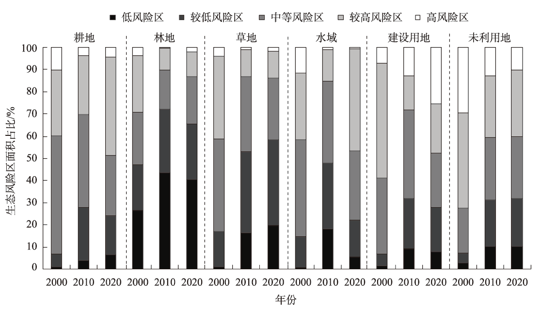
Area changes of ecological risk areas from 2000 to 2020"
| 年份 | 低风险区 | 较低风险区 | 中等风险区 | 较高风险区 | 高风险区 | |||||||||
|---|---|---|---|---|---|---|---|---|---|---|---|---|---|---|
| 面积/km2 | 占比/% | 面积/km2 | 占比/% | 面积/km2 | 占比/% | 面积/km2 | 占比/% | 面积/km2 | 占比/% | |||||
| 2000 | 166.96 | 2.55 | 758.26 | 11.57 | 2255.94 | 34.42 | 2768.63 | 42.25 | 603.63 | 9.21 | ||||
| 2010 | 945.08 | 14.42 | 2029.06 | 30.96 | 2228.08 | 34.00 | 1144.39 | 17.46 | 206.81 | 3.16 | ||||
| 2020 | 1091.77 | 16.66 | 2120.90 | 32.36 | 1899.01 | 28.98 | 1181.99 | 18.04 | 259.75 | 3.96 | ||||
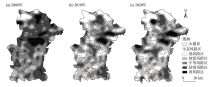
Fig. 2
Spatial distributions of ecological risk areas from 2000 to 2020"

Tab. 7
Transfer process of different levels of ecological risk areas from 2000 to 2020"
| 生态风险转移类型 | 2000—2010年 | 2010—2020年 | 2000—2020年 | |||||
|---|---|---|---|---|---|---|---|---|
| 转换面积/km2 | 转换速率/km2·a-1 | 转换面积/km2 | 转换速率/km2·a-1 | 转换面积/km2 | 转换速率/km2·a-1 | |||
| 低—较低 | 0.00 | 0.00 | 126.32 | 12.63 | 3.93 | 0.39 | ||
| 低—中等 | 0.00 | 0.00 | 28.65 | 2.86 | 0.03 | 0.00 | ||
| 低—较高 | 0.00 | 0.00 | 3.62 | 0.36 | 0.00 | 0.00 | ||
| 低—高 | 0.00 | 0.00 | 0.02 | 0.00 | 0.00 | 0.00 | ||
| 较低—低 | 341.17 | 34.12 | 299.92 | 29.99 | 463.24 | 46.32 | ||
| 较低—中等 | 6.11 | 0.61 | 201.17 | 20.12 | 18.00 | 1.80 | ||
| 较低—较高 | 4.74 | 0.47 | 43.59 | 4.36 | 14.99 | 1.50 | ||
| 较低—高 | 0.35 | 0.03 | 10.02 | 1.00 | 6.34 | 0.63 | ||
| 中等—低 | 228.61 | 22.86 | 5.37 | 0.54 | 226.95 | 22.70 | ||
| 中等—较低 | 1135.28 | 113.53 | 481.79 | 48.18 | 1278.13 | 127.81 | ||
| 中等—较高 | 38.71 | 3.87 | 286.51 | 28.65 | 179.02 | 17.90 | ||
| 中等—高 | 18.33 | 1.83 | 23.10 | 2.31 | 51.66 | 5.17 | ||
| 较高—低 | 171.40 | 17.14 | 0.00 | 0.00 | 193.19 | 19.32 | ||
| 较高—较低 | 409.17 | 40.92 | 38.44 | 3.84 | 502.28 | 50.23 | ||
| 较高—中等 | 1307.91 | 130.79 | 234.43 | 23.44 | 1266.21 | 126.62 | ||
| 较高—高 | 46.12 | 4.61 | 65.43 | 6.54 | 96.96 | 9.70 | ||
| 高—低 | 36.94 | 3.69 | 0.00 | 0.00 | 45.39 | 4.54 | ||
| 高—较低 | 78.71 | 7.87 | 0.00 | 0.00 | 80.87 | 8.09 | ||
| 高—中等 | 79.05 | 7.90 | 3.45 | 0.34 | 94.59 | 9.46 | ||
| 高—较高 | 266.91 | 26.69 | 42.18 | 4.22 | 277.99 | 27.80 | ||
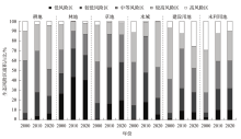
Fig. 3
Area proportion of ecological risk areas of different land types from 2000 to 2020"
Tab. 8
Detected value of influencing factors of ecological risk spatial differentiation"
| 影响因素 | 影响因子 | 贡献率/% | ||
|---|---|---|---|---|
| 2000年 | 2010年 | 2020年 | ||
| 自然 | 高程 | 6.86 | 5.96 | 5.28 |
| 坡度 | 3.06 | 3.09 | 3.08 | |
| 年均降水量 | 10.79 | 7.29 | 8.15 | |
| 年均气温 | 5.06 | 4.86 | 6.29 | |
| 归一化植被指数(NDVI) | 4.29 | 3.75 | 4.01 | |
| 土壤有机质含量 | 3.43 | 3.09 | 3.28 | |
| 社会经济 | 土地利用程度 | 14.36 | 13.79 | 15.22 |
| 人为干扰度 | 24.56 | 26.49 | 29.67 | |
| 人均GDP | 5.46 | 6.82 | 8.77 | |
| 人口密度 | 3.42 | 3.87 | 3.72 | |
| 区域可达性 | 距道路距离 | 2.75 | 3.07 | 3.98 |
| 距水域面积 | 1.47 | 1.69 | 1.55 | |
| 距城镇中心距离 | 2.16 | 3.09 | 3.06 | |
| [1] | 崔佳, 臧淑英. 哈大齐工业走廊土地利用变化的生态环境效应[J]. 地理研究, 2013, 32(5): 848-856. |
| [Cui Jia, Zang Shuying. Regional disparities of land use changes and their eco-environmental effects in Harbin-Daqing-Qiqihar Industrial Corridor[J]. Geographical Research, 2013, 32(5): 848-856. ] | |
| [2] |
刘永强, 廖柳文, 龙花楼, 等. 土地利用转型的生态系统服务价值效应分析——以湖南省为例[J]. 地理研究, 2015, 34(4): 691-700.
doi: 10.11821/dlyj201504008 |
|
[Liu Yongqiang, Liao Liuwen, Long Hualou, et al. Effects of land use transitions on ecosystem services value: A case study of Hunan Province[J]. Geographical Research, 2015, 34(4): 691-700. ]
doi: 10.11821/dlyj201504008 |
|
| [3] |
刘迪, 陈海, 耿甜伟, 等. 基于地貌分区的陕西省区域生态风险时空演变[J]. 地理科学进展, 2020, 39(2): 243-254.
doi: 10.18306/dlkxjz.2020.02.006 |
|
[Liu Di, Chen Hai, Geng Tianwei, et al. Spatiotemporal changes of regional ecological risks in Shaanxi Province based on geomorphologic regionalization[J]. Progress in Geography, 2020, 39(2): 243-254. ]
doi: 10.18306/dlkxjz.2020.02.006 |
|
| [4] |
王帅, 傅伯杰, 武旭同, 等. 黄土高原社会-生态系统变化及其可持续性[J]. 资源科学, 2020, 42(1): 96-103.
doi: 10.18402/resci.2020.01.10 |
|
[Wang Shuai, Fu Bojie, Wu Xutong, et al. Dynamics and sustainability of social-ecological systems in the Loess Plateau[J]. Resources Science, 2020, 42(1): 96-103. ]
doi: 10.18402/resci.2020.01.10 |
|
| [5] |
彭建, 杜悦悦, 刘焱序, 等. 从自然区划、土地变化到景观服务: 发展中的中国综合自然地理学[J]. 地理研究, 2017, 36(10): 1819-1833.
doi: 10.11821/dlyj201710001 |
|
[Peng Jian, Du Yueyue, Liu Yanxu, et al. From natural regionalization, land change to landscape service: The development of integrated physical geography in China[J]. Geographical Research, 2017, 36(10): 1819-1833. ]
doi: 10.11821/dlyj201710001 |
|
| [6] |
Forbes V E, Calow P. Developing predictive systems models to address complexity and relevance for ecological risk assessment[J]. Integrated Environmental Assessment Management, 2013, 9(3): e75-e80.
doi: 10.1002/ieam.1425 |
| [7] | 熊鹰, 汪敏, 袁海平, 等. 洞庭湖区景观生态风险评价及其时空演化[J]. 生态环境学报, 2020, 29(7): 1292-1301. |
| [Xiong Ying, Wang Min, Yuan Haiping, et al. Landscape ecological risk assessment and its spatio-temporal evolution in Dongting Lake area[J]. Acta Eco-Environmental Sciences, 2020, 29(7): 1292-1301. ] | |
| [8] | 汪翡翠, 汪东川, 张利辉, 等. 京津冀城市群土地利用生态风险的时空变化分析[J]. 生态学报, 2018, 38(12): 4307-4316. |
| [Wang Feicui, Wang Dongchuan, Zhang Lihui, et al. Spatiotemporal analysis of the dynamic changes in land use ecological risks in the urban agglomeration of Beijing-Tianjin-Hebei region[J]. Acta Ecologica Sinica, 2018, 38(12): 4307-4316. ] | |
| [9] | 何莎莎, 李欣, 何春龙, 等. 基于土地利用变化的扬州市广陵区景观生态风险评价[J]. 南京师大学报(自然科学版), 2019, 42(1): 139-148. |
| [He Shasha, Li Xin, He Chunlong, et al. Landscape ecological risk assessment in Guangling District of Yangzhou City based on land use change[J]. Journal of Nanjing Normal University (Natural Science Edition), 2019, 42(1): 139-148. ] | |
| [10] |
彭建, 党威雄, 刘焱序, 等. 景观生态风险评价研究进展与展望[J]. 地理学报, 2015, 70(4): 664-677.
doi: 10.11821/dlxb201504013 |
|
[Peng Jian, Dang Weixiong, Liu Yanxu, et al. Review on landscape ecological risk assessment[J]. Acta Geographica Sinica, 2015, 70(4): 664-677. ]
doi: 10.11821/dlxb201504013 |
|
| [11] |
曹祺文, 张曦文, 马洪坤, 等. 景观生态风险研究进展及基于生态系统服务的评价框架: ESRISK[J]. 地理学报, 2018, 73(5): 843-855.
doi: 10.11821/dlxb201805005 |
|
[Cao Qiwen, Zhang Xiwen, Ma Hongkun, et al. Review of landscape ecological risk and an assessment framework based on ecological services: ESRISK[J]. Acta Geographica Sinica, 2018, 73(5): 843-855. ]
doi: 10.11821/dlxb201805005 |
|
| [12] | 周启刚, 张晓媛, 王兆林. 基于正态云模型的三峡库区土地利用生态风险评价[J]. 农业工程学报, 2014, 30(23): 289-297. |
| [Zhou Qigang, Zhang Xiaoyuan, Wang Zhaolin. Land use ecological risk evaluation in Three Gorges Reservoir Area based on normal cloud model[J]. Transactions of the Chinese Society of Agricultural Engineering, 2014, 30(23): 289-297. ] | |
| [13] |
Kanwar P, Bowden W B, Greenhalgh S. A regional ecological risk assessment of the Kaipara Harbour, New Zealand, using a relative risk model[J]. Human and Ecological Risk Assessment: An International Journal, 2015, 21(4): 1123-1146.
doi: 10.1080/10807039.2014.976046 |
| [14] |
刘焱序, 王仰麟, 彭建, 等. 基于生态适应性循环三维框架的城市景观生态风险评价[J]. 地理学报, 2015, 70(7): 1052-1067.
doi: 10.11821/dlxb201507003 |
|
[Liu Yanxu, Wang Yanglin, Peng Jian, et al. Urban landscape ecological risk assessment based on the 3D framework of adaptive cycle[J]. Acta Geographica Sinica, 2015, 70(7): 1052-1067. ]
doi: 10.11821/dlxb201507003 |
|
| [15] |
郑度, 吴绍洪, 尹云鹤, 等. 全球变化背景下中国自然地域系统研究前沿[J]. 地理学报, 2016, 71(9): 1475-1483.
doi: 10.11821/dlxb201609001 |
|
[Zheng Du, Wu Shaohong, Yin Yunhe, et al. Frontiers in terrestrial system research in China under global change[J]. Acta Geographica Sinica, 2016, 71(9): 1475-1483. ]
doi: 10.11821/dlxb201609001 |
|
| [16] | 康紫薇, 张正勇, 位宏, 等. 基于土地利用变化的玛纳斯河流域景观生态风险评价[J]. 生态学报, 2020, 40(18): 6472-6485. |
| [Kang Ziwei, Zhang Zhengyong, Wei Hong, et al. Landscape ecological risk assessment in Manas River Basin based on land use change[J]. Acta Ecologica Sinica, 2020, 40(18): 6472-6485. ] | |
| [17] | 景培清, 张东海, 艾泽民, 等. 基于格局-过程生态适应性循环三维框架的自然景观生态风险评价——以黄土高原为例[J]. 生态学报, 2021, 41(17): 7026-7036. |
| [Jing Peiqing, Zhang Donghai, Ai Zemin, et al. Natural landscape ecological risk assessment based on the three-dimensional framework of pattern-process ecological adaptability cycle: A case in Loess Plateau[J]. Acta Ecologica Sinica, 2021, 41(17): 7026-7036. ] | |
| [18] | 傅微, 吕一河, 傅伯杰, 等. 陕北黄土高原典型人类活动影响下景观生态风险评价[J]. 生态与农村环境学报, 2019, 35(3): 290-299. |
| [Fu Wei, Lü Yihe, Fu Bojie, et al. Landscape ecological risk assessment under the influence of typical human activities in Loess Plateau, northern Shaanxi[J]. Journal of Ecology and Rural Environment, 2019, 35(3): 290-299. ] | |
| [19] |
程琳琳, 刘华, 刘焱序. 半干旱区县域景观格局变化轨迹识别——以宁夏盐池县为例[J]. 自然资源学报, 2019, 34(5): 1066-1078.
doi: 10.31497/zrzyxb.20190513 |
|
[Cheng Linlin, Liu Hua, Liu Yanxu. Track the county level landscape pattern change in semiarid region: A case study in Yanchi County, Ningxia, northwest China[J]. Journal of Natural Resources, 2019, 34(5): 1066-1078. ]
doi: 10.31497/zrzyxb.20190513 |
|
| [20] | 夏翠珍, 周立华, 廖杰, 等. 生态治理政策工具对农户行为影响差异研究——以宁夏盐池县为例[J]. 生态学报, 2021, 41(23): 9253-9265. |
| [Xia Cuizhen, Zhou Lihua, Liao Jie, et al. Difference effects of policy instruments of ecological governance on farmers’ behaviors: A case study of Yanchi County[J]. Acta Ecologica Sinica, 2021, 41(23): 9253-9265. ] | |
| [21] | 王鹏, 王亚娟, 刘小鹏, 等. 干旱区生态移民土地利用景观格局变化分析——以宁夏红寺堡区为例[J]. 干旱区资源与环境, 2018, 32(12): 69-74. |
| [Wang Peng, Wang Yajuan, Liu Xiaopeng, et al. Change of land use and landscape pattern in ecological resettlement area in central Ningxia[J]. Arid Land Resources and Environment, 2018, 32(12): 69-74. ] | |
| [22] | 李理, 朱连奇, 朱博文, 等. 生态系统服务价值与人类活动强度关联性分析及权衡——以七河流域为例[J]. 中国环境科学, 2020, 40(1): 365-374. |
| [Zhu Lianqi, Zhu Bowen, et al. The correlation between ecosystem service value and human activity intensity and its trade-offs: Take Qihe River Basin for example[J]. China Environmental Science, 2020, 40(1): 365-374. ] | |
| [23] | 黄越, 程静, 王鹏. 中国北方农牧交错区生态脆弱性时空演变格局与驱动因素——以盐池县为例[J]. 干旱区地理, 2021, 44(4): 1175-1185. |
| [Huang Yue, Cheng Jing, Wang Peng. Spatiotemporal evolution pattern and driving factors of ecological vulnerability in agro-pastoral region in northern China: A case of Yanchi County in Ningxia[J]. Arid Land Geography, 2021, 44(4): 1175-1185. ] | |
| [24] | 韩鑫, 刘传胜, 胡江玲, 等. 新疆天山自然遗产地景观格局动态演化及其生态健康评价[J]. 干旱区地理, 2019, 42(1): 195-205. |
| [Han Xin, Liu Chuansheng, Hu Jiangling, et al. Dynamic evolution of landscape pattern and ecological health assessment of Tianshan Natural Heritage Site in Xinjiang[J]. Arid Land Geography, 2019, 42(1): 195-205. ] | |
| [25] | 曾红霞, 赵成章, 王毓芳, 等. 盐池湾高寒湿地景观格局演变及其影响因素[J]. 干旱区研究, 2021, 38(6): 1771-1781. |
| [Zeng Hongxia, Zhao Chengzhang, Wang Yufang, et al. Landscape pattern evolution and its influencing factors of alpine wetland in Yanchi Bay[J]. Arid Zone Research, 2021, 38(6): 1771-1781. ] | |
| [26] | 王鹏, 王亚娟, 刘小鹏, 等. 基于景观结构的生态移民安置区生态风险评价——以宁夏红寺堡区为例[J]. 生态学报, 2018, 38(8): 2672-2682. |
| [Wang Peng, Wang Yajuan, Liu Xiaopeng, et al. Ecological risk assessment of an ecological migrant resettlement region based on landscape structure: A case study of Hongsibu in Ningxia[J]. Acta Ecologica Sinica, 2018, 38(8): 2672-2682. ] | |
| [27] | 刘希朝, 李效顺, 蒋冬梅. 基于土地利用变化的黄河流域景观格局及生态风险评估[J]. 农业工程学报, 2021, 37(4): 265-274. |
| [Liu Xichao, Li Xiaoshun, Jiang Dongmei. Landscape pattern identification and ecological risk assessment using land-use change in the Yellow River Basin[J]. Transactions of the Chinese Society of Agricultural Engineering, 2021, 37(4): 265-274. ] | |
| [28] | 张学斌, 石培基, 罗君, 等. 基于景观格局的干旱内陆河流域生态风险分析——以石羊河流域为例[J]. 自然资源学报, 2014, 29(3): 410-419. |
| [Zhang Xuebin, Shi Peiji, Luo Jun, et al. The ecological risk assessment of arid inland river basin at the landscape scale: A case study on Shiyang River Basin[J]. Journal of Natural Resources, 2014, 29(3): 410-419. ] | |
| [29] |
王劲峰, 徐成东. 地理探测器: 原理与展望[J]. 地理学报, 2017, 72(1): 116-134.
doi: 10.11821/dlxb201701010 |
|
[Wang Jinfeng, Xu Chengdong. Geographic detectors: Principles and prospects[J]. Acta Geographica Sinica, 2017, 72(1): 116-134. ]
doi: 10.11821/dlxb201701010 |
|
| [30] | 孙丽蓉, 周冬梅, 岑国璋, 等. 基于地理探测器模型的疏勒河流域景观生态风险评价及驱动因素分析[J]. 干旱区地理, 2021, 44(5): 1384-1395. |
| [Sun Lirong, Zhou Dongmei, Cen Guozhang, et al. Landscape ecological risk assessment and driving factors of the Shule River Basin based on the geographic detector model[J]. Arid Land Geography, 2021, 44(5): 1384-1395. ] | |
| [31] | 王敏, 胡守庚, 张绪冰, 等. 干旱区绿洲城镇景观生态风险时空变化分析——以张掖绿洲乡镇为例[J]. 生态学报, 2022, 42(14): 1-13. |
| [Wang Min, Hu Shougeng, Zhang Xubing, et al. Spatio-temporal evolution of landscape ecological risk in oasis cities and towns of arid area: A case study of Zhangye oasis township[J]. Acta Ecologica Sinica, 2022, 42(14): 1-13. ] | |
| [32] | 杨亚芳, 何杰, 刘振沧, 等. 宁夏盐池县土地利用转型的生态系统服务价值评估[J]. 石河子大学学报(自然科学版), 2021, 39(6): 720-726. |
| [Yang Yafang, He Jie, Liu Zhencang, et al. Evaluation of ecosystem service value of land use transformation in Yanchi County of Ningxia[J]. Journal of Shihezi University (Natural Science Edition), 2021, 39(6): 720-726. ] | |
| [33] | 刘淑琴, 王荣女, 夏朝宗, 等. 土地利用变化对盐池县碳储量及其价值影响[J]. 干旱区研究, 2018, 35(2): 486-492. |
| [Liu Shuqin, Wang Rongnv, Xia Chaozong, et al. Effects of land use change on carbon reserve and carbon sink value in Yanchi County[J]. Arid Zone Research, 2018, 35(2): 486-492. ] | |
| [34] | 张晓东, 刘湘南, 赵志鹏, 等. 基于Landsat影像的宁夏盐池县植被景观格局变化特征[J]. 西北农林科技大学学报(自然科学版), 2018, 46(6): 75-84. |
| [Zhang Xiaodong, Liu Xiangnan, Zhao Zhipeng, et al. Characteristic changes of landscape pattern in Yanchi, Ningxia based on Landsat image[J]. Journal of Northwest A&F University (Natural Science Edition), 2018, 46(6): 75-84. ] | |
| [35] | 巩杰, 谢余初, 赵彩霞, 等. 甘肃白龙江流域景观生态风险评价及其时空分异[J]. 中国环境科学, 2014, 34(8): 2153-2160. |
| [Gong Jie, Xie Yuchu, Zhao Caixia, et al. Landscape ecological risk assessment and its spatiotemporal variation of Bailong watershed, Gansu[J]. China Environmental Science, 2014, 34(8): 2153-2160. ] | |
| [36] | 黄木易, 何翔. 近20年来巢湖流域景观生态风险评估与时空演化机制[J]. 湖泊科学, 2016, 28(4): 785-793. |
| [Huang Muyi, He Xiang. Landscape ecological risk assessment and its mechanism in Chaohu Basin during the past almost 20 years[J]. Lake Science, 2016, 28(4): 785-793. ] | |
| [37] | 刘世梁, 刘琦, 张兆苓, 等. 云南省红河流域景观生态风险及驱动力分析[J]. 生态学报, 2014, 34(13): 3728-3734. |
| [Liu Shiliang, Liu Qi, Zhang Zhaoling, et al. Landscape ecological risk and driving force analysis in Red River Basin[J]. Acta Ecologica Sinica, 2014, 34(13): 3728-3734. ] | |
| [38] | 吕乐婷, 张杰, 孙才志, 等. 基于土地利用变化的细河流域景观生态风险评估[J]. 生态学报, 2018, 38(16): 5952-5960. |
| [Lü Leting, Zhang Jie, Sun Caizhi, et al. Landscape ecological risk assessment of Xi River Basin based on land-use change[J]. Acta Ecologica Sinica, 2018, 38(16): 5952-5960. ] |
| [1] | PENG Ya, WANG Juanjuan, WANG Shanshan, TIAN Liulan, LIU Jie, WU Zhaopeng. Spatiotemporal pattern evolution of land use conflict in Urumqi City from the perspective of ecological security [J]. Arid Land Geography, 2024, 47(1): 81-92. |
| [2] | LI Jianhui, CHEN Lin, DANG Zheng. Spatial pattern and influencing factors of patriotic education bases in the Yellow River Basin [J]. Arid Land Geography, 2023, 46(9): 1536-1544. |
| [3] | ZHANG Hao, HAN Zenglin, QIAO Guorong, WANG Hui, WANG Hongye, DUAN Ye. Patterns and influencing factors of tourism economic linkages between cities in the Yellow River Basin [J]. Arid Land Geography, 2023, 46(8): 1344-1354. |
| [4] | KANG Ligang, CAO Shengkui, CAO Guangchao, YAN Li, CHEN Lianxuan, LI Wenbin, ZHAO Haoran. Spatiotemporal variation of land surface temperature in Qinghai Lake Basin [J]. Arid Land Geography, 2023, 46(7): 1084-1097. |
| [5] | ZHU Lei, LI Yannan, HU Jing, TIAN Xiaobo, XU Jiahui, QING Qi. Multi-scale characteristics and influencing mechanism of spatial pattern on research and practice bases in China [J]. Arid Land Geography, 2023, 46(4): 625-635. |
| [6] | CHENG Jing,WANG Peng,CHEN Hongxiang,HAN Yonggui. Spatiotemporal evolution of habitat quality in the Weihe River Basin and its topographic gradient effects and influencing factors [J]. Arid Land Geography, 2023, 46(3): 481-491. |
| [7] | LU Chenyu,HUANG Ping,ZHANG Tong,LIU Xiaowan,CHENG Wei. Spatiotemporal evolution and driving factors of the green development efficiency in Gansu Province [J]. Arid Land Geography, 2023, 46(2): 305-315. |
| [8] | YANG Yang, QIAO Jiajun, WANG Wei, ZHANG Ershen. Impact of poverty alleviation resource allocation on income of rural low-income farmer households: A case of 18 villages in Qinghai Province [J]. Arid Land Geography, 2023, 46(2): 325-336. |
| [9] | NI Honghong, MA Qiang, BU Yuankun, YANG Xiaoxuan, LI Weizhong. Spatiotemporal distribution pattern evolution and influencing factors of forestry enterprises in Shaanxi Province [J]. Arid Land Geography, 2023, 46(12): 2098-2110. |
| [10] | MA Xiaomin, ZHANG Zhibin, GUO Qianqian, WU Zhixiang, FENG Xueli. Spatial distribution, type structure and influencing factors of popular science education bases in China [J]. Arid Land Geography, 2023, 46(11): 1879-1890. |
| [11] | DONG Chunyuan, HUANG Haitao, QIAO Rongrong, LUO Lihui, CHANG Xueli. Spatiotemporal variations and scale dependence of landscape diversity in oasis along the Yellow River in Ningxia [J]. Arid Land Geography, 2023, 46(1): 76-85. |
| [12] | HE Junqi,WEI Yan,GAO Wande,CHEN Yunfei,MA Yandong,LIU Xiuhua. Temporal and spatial variation of vegetation NDVI and its response to climatic factors in the southeastern margin of Mu Us Sandy Land [J]. Arid Land Geography, 2022, 45(5): 1523-1533. |
| [13] | ZHANG Xiaodong,ZHAO Zhipeng,ZHAO Yinxin,GAO Xuehua,MA Yuxue,LIU Naijing,JI Weibo. Landscape ecological risk assessment and ecological security pattern optimization construction in Yinchuan City [J]. Arid Land Geography, 2022, 45(5): 1626-1636. |
| [14] | REN Liqing. Spatiotemporal change and driving force of vegetation in Ebinur Lake Basin [J]. Arid Land Geography, 2022, 45(2): 467-477. |
| [15] | ZHANG Junmin,RONG Cheng,MA Yuxiang. Spatial and temporal differences and driving factors of the green development of urbanization in Xinjiang [J]. Arid Land Geography, 2022, 45(1): 251-262. |
|
||