- Aug. 13, 2025
Arid Land Geography ›› 2025, Vol. 48 ›› Issue (2): 308-322.doi: 10.12118/j.issn.1000-6060.2024.320
• Ecology and Environment • Previous Articles Next Articles
ZHANG Zihan1,2( ), WANG Jinjie1,2, DING Jianli2,3(), ZHANG Jinming1,2, GE Xiangyu1,2
Received:2024-05-26
Revised:2024-06-11
Online:2025-02-25
Published:2025-02-25
Contact:
DING Jianli
E-mail:107552301154@stu.xju.edu.cn;dingjl@xju.edu.cn
ZHANG Zihan, WANG Jinjie, DING Jianli, ZHANG Jinming, GE Xiangyu. Analysis and prediction of landscape ecological risk in Ebinur Lake Basin based on PLUS model[J].Arid Land Geography, 2025, 48(2): 308-322.
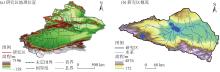
Fig. 1
Schematic diagram of the study area"
Tab. 1
Data sources and information of the study"
| 数据类型 | 数据名称 | 数据来源 |
|---|---|---|
| 基础数据 | 土地利用数据 | 武汉大学黄昕教授团队制作的中国30 m分辨率年度土地覆盖产品,产品整体精度为79.31%( |
| 行政边界数据 | 中国科学院资源环境与数据中心( | |
| 社会经济数据 | 人口 | Worldpop( |
| GDP | 中国科学院资源环境与数据中心( | |
| 距一级道路距离 | OpenStreetMap( OpenStreetMap( OpenStreetMap( OpenStreetMap( OpenStreetMap( | |
| 距二级道路距离 | ||
| 距三级道路距离 | ||
| 距铁路距离 | ||
| 距高速距离 | ||
| 气候环境数据 | 高程 | 地理空间数据云( |
| 坡度 | 地理空间数据云( | |
| 年降水量 | 中国科学院资源环境与数据中心( 中国科学院资源环境与数据中心( 中国科学院资源环境与数据中心( 中国科学院资源环境与数据中心( | |
| 年均气温 | ||
| 土壤类型数据 | ||
| NDVI |
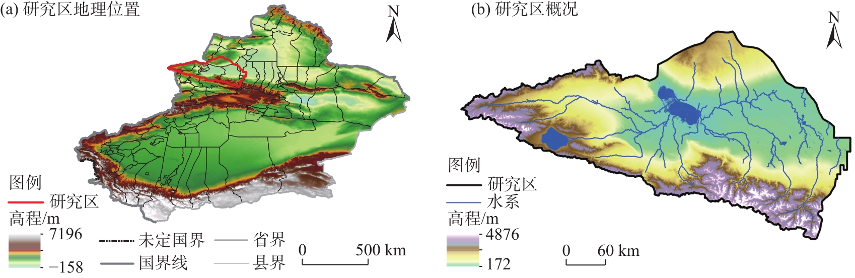
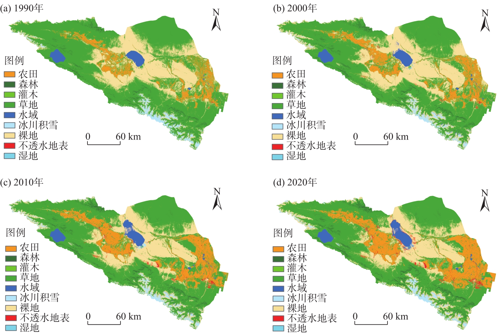
Fig. 2
Distributions of land use types in the study area from 1990 to 2020"
Tab. 2
Changes in the area of land use types in Ebinur Lake Basin from 1990 to 2020"
| 土地利用类型 | 1990年 | 2000年 | 2010年 | 2020年 | |||||||
|---|---|---|---|---|---|---|---|---|---|---|---|
| 面积/km2 | 占比/% | 面积/km2 | 占比/% | 面积/km2 | 占比/% | 面积/km2 | 占比/% | ||||
| 农田 | 3709.40 | 7.83 | 4678.50 | 9.87 | 6384.30 | 13.47 | 7383.80 | 15.58 | |||
| 森林 | 511.10 | 1.08 | 728.00 | 1.54 | 897.10 | 1.89 | 1039.02 | 2.19 | |||
| 灌木 | 0.09 | 0.00 | 0.01 | 0.00 | 0.01 | 0.00 | 0.05 | 0.00 | |||
| 草地 | 29115.40 | 61.45 | 27175.50 | 57.36 | 26707.50 | 56.37 | 25238.50 | 53.27 | |||
| 水域 | 1113.40 | 2.35 | 1268.30 | 2.68 | 1464.00 | 3.09 | 1512.10 | 3.19 | |||
| 冰川积雪 | 1390.90 | 2.94 | 1211.00 | 2.56 | 1300.10 | 2.74 | 1185.50 | 2.50 | |||
| 裸地 | 11514.10 | 24.30 | 12177.70 | 25.70 | 10238.40 | 21.61 | 10384.50 | 21.92 | |||
| 不透水地表 | 25.80 | 0.05 | 141.20 | 0.30 | 388.80 | 0.82 | 636.70 | 1.34 | |||
| 湿地 | 0.89 | 0.002 | 0.86 | 0.002 | 0.82 | 0.002 | 0.88 | 0.002 | |||
Tab. 3
Dynamic changes of land use types in Ebinur Lake Basin from 1990 to 2020"
| 土地利用类型 | 单一土地利用动态度/% | |||
|---|---|---|---|---|
| 1990—2000年 | 2000—2010年 | 2010—2020年 | 1990—2020年 | |
| 农田 | 2.61 | 3.65 | 1.57 | 3.30 |
| 森林 | 4.25 | 2.32 | 1.58 | 3.45 |
| 灌木 | -7.97 | -3.13 | 42.73 | -0.89 |
| 草地 | -0.67 | -0.17 | -0.55 | -0.44 |
| 水域 | 1.39 | 1.54 | 0.33 | 1.19 |
| 冰川积雪 | -1.29 | 0.74 | -0.88 | -0.49 |
| 裸地 | 0.57 | -1.59 | 0.14 | -0.33 |
| 不透水地表 | 45.15 | 17.53 | 6.38 | 79.54 |
| 湿地 | -0.64 | -0.49 | 0.72 | -0.15 |
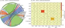
Fig. 3
Land use transition matrix in Ebinur Lake Basin from 1990 to 2020"
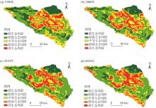
Fig. 4
Spatial distributions of landscape ecological risks in Ebinur Lake Basin from 1990 to 2020"
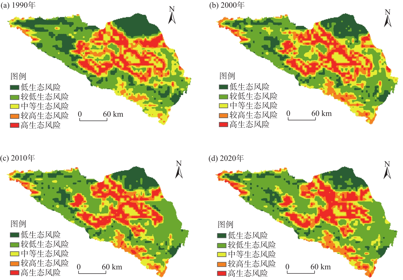
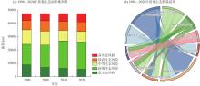
Fig. 5
Landscape ecological risk area transfer in Ebinur Lake Basin from 1990 to 2020"

Tab. 4
Changes of landscape ecological risk area in Ebinur Lake Basin from 1990 to 2020"
| 生态风险等级 | 1990年 | 2000年 | 2010年 | 2020年 | |||||||
|---|---|---|---|---|---|---|---|---|---|---|---|
| 面积/km2 | 占比/% | 面积/km2 | 占比/% | 面积/km2 | 占比/% | 面积/km2 | 占比/% | ||||
| 低生态风险 | 8892.86 | 18.76 | 6970.40 | 14.71 | 6261.86 | 13.21 | 5659.81 | 11.94 | |||
| 较低生态风险 | 15431.70 | 32.56 | 16789.40 | 35.42 | 20668.50 | 43.60 | 20459.90 | 43.16 | |||
| 中等生态风险 | 10864.90 | 22.92 | 10391.70 | 21.92 | 7805.86 | 16.47 | 7793.12 | 16.44 | |||
| 较高生态风险 | 6997.43 | 14.76 | 7851.17 | 16.56 | 6700.01 | 14.13 | 7172.48 | 15.13 | |||
| 高生态风险 | 5213.46 | 11.00 | 5397.66 | 11.39 | 5964.09 | 12.58 | 6315.05 | 13.32 | |||
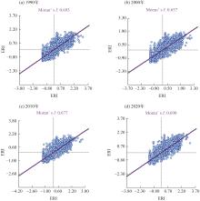
Fig. 6
Moran index of landscape ecological risk in Ebinur Lake Basin from 1990 to 2020"

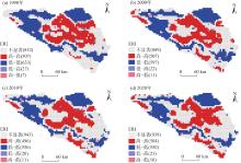
Fig. 7
LISA cluster diagrams of landscape ecological risk from 1990 to 2020"
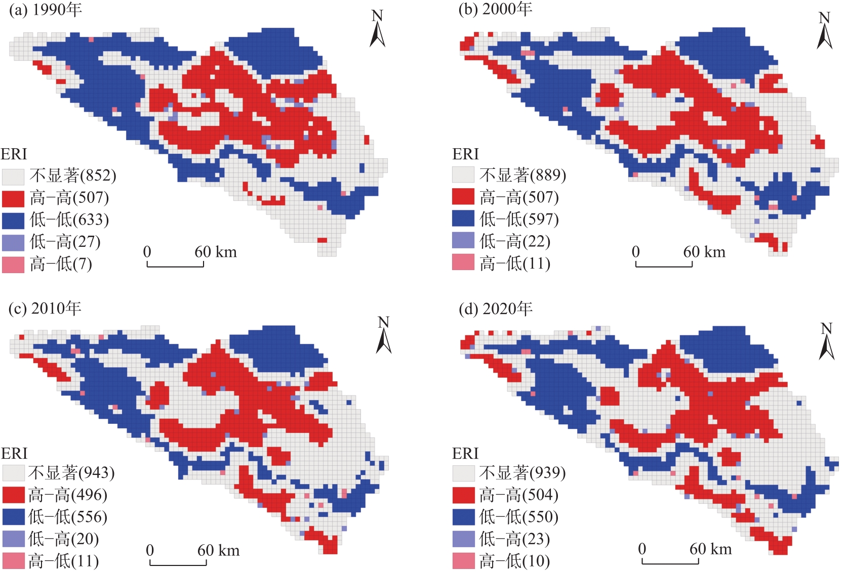

Fig. 8
Distribution of land use types by scenario in Ebinur Lake Basin in 2030"

Tab. 5
Changes of land use type area in Ebinur Lake Basin under different scenarios in 2030"
| 土地利用类型 | 自然发展情景 | 城镇发展情景 | 生态保护情景 | 耕地保护情景 | |||||||
|---|---|---|---|---|---|---|---|---|---|---|---|
| 面积/km2 | 占比/% | 面积/km2 | 占比/% | 面积/km2 | 占比/% | 面积/km2 | 占比/% | ||||
| 农田 | 8250.15 | 17.41 | 8125.64 | 17.15 | 7344.16 | 15.50 | 8268.81 | 17.45 | |||
| 森林 | 1173.89 | 2.48 | 1173.78 | 2.48 | 1212.53 | 2.56 | 1173.92 | 2.48 | |||
| 灌木 | 0.06 | 0.00 | 0.05 | 0.00 | 0.05 | 0.00 | 0.07 | 0.00 | |||
| 草地 | 24008.80 | 50.67 | 23996.60 | 50.65 | 25515.40 | 53.85 | 24010.00 | 50.67 | |||
| 水域 | 1555.44 | 3.28 | 1555.06 | 3.28 | 1550.53 | 3.27 | 1555.46 | 3.28 | |||
| 冰川积雪 | 1235.62 | 2.61 | 1221.42 | 2.58 | 1212.16 | 2.56 | 1234.31 | 2.61 | |||
| 裸地 | 10401.40 | 21.95 | 10400.70 | 21.95 | 9883.60 | 20.86 | 10401.40 | 21.95 | |||
| 不透水地表 | 755.25 | 1.59 | 907.36 | 1.92 | 661.68 | 1.40 | 736.69 | 1.55 | |||
| 湿地 | 0.42 | 0.00 | 0.42 | 0.00 | 0.89 | 0.00 | 0.37 | 0.00 | |||
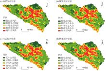
Fig. 9
Spatial distribution of landscape ecological risks in Ebinur Lake Basin in 2030"

Tab. 6
Landscape ecological risk levels of Ebinur Lake Basin in 2030"
| 生态风险等级 | 自然发展情景 | 城镇发展情景 | 生态保护情景 | 耕地保护情景 | |||||||
|---|---|---|---|---|---|---|---|---|---|---|---|
| 面积/km2 | 占比/% | 面积/km2 | 占比/% | 面积/km2 | 占比/% | 面积/km2 | 占比/% | ||||
| 低生态风险 | 5977.28 | 12.61 | 5891.53 | 12.43 | 6088.50 | 12.84 | 5886.65 | 12.42 | |||
| 较低生态风险 | 20865.60 | 43.02 | 20957.40 | 44.21 | 20905.90 | 44.10 | 20921.70 | 44.14 | |||
| 中等生态风险 | 7705.54 | 16.26 | 7798.08 | 16.45 | 7883.72 | 16.63 | 7745.13 | 16.34 | |||
| 较高生态风险 | 6783.66 | 14.31 | 6759.80 | 14.26 | 6856.28 | 14.46 | 6752.29 | 14.25 | |||
| 高生态风险 | 6068.27 | 12.80 | 5993.57 | 12.64 | 5665.92 | 11.95 | 6094.58 | 12.86 | |||
| [2] | Tian P, Li J L, Gong H B, et al. Research on land use changes and ecological risk assessment in Yongjiang River Basin in Zhejiang Province, China[J]. Sustainability, 2019, 1(10): 2817, doi: 10.3390/su11102817. |
| [3] | 莫贵芬, 冯建中, 王中美, 等. 中亚阿姆河跨境流域景观生态风险时空演变特征分析[J]. 干旱地区农业研究, 2022, 40(1): 123-131. |
| [Mo Guifen, Feng Jianzhong, Wang Zhongmei, et al. Spatial-temporal evolution characteristics of landscape ecological risk in the transboundary basin of Amu Darya River, Central Asia[J]. Agricultural Research in the Arid Areas, 2022, 40(1): 123-131. ] | |
| [4] |
Huang H, Wang P, Xie H. Ecological risk assessment of land use change in the Poyang Lake eco-economic zone, China[J]. International Journal of Environmental Research and Public Health, 2013, 10(1): 328-346.
doi: 10.3390/ijerph10010328 pmid: 23343986 |
| [5] | 汪翡翠, 汪东川, 张利辉, 等. 京津冀城市群土地利用生态风险的时空变化分析[J]. 生态学报, 2018, 38(12): 4307-4316. |
| [Wang Feicui, Wang Dongchuan, Zhang Lihui, et al. Spatiotemporal analysis of the dynamic changes in land use ecological risks in the urban agglomeration of Beijing-Tianjin-Hebei region[J]. Acta Ecologica Sinica, 2018, 38(12): 4307-4316. ] | |
| [6] | 井云清, 张飞, 陈丽华, 等. 艾比湖湿地土地利用/覆被-景观格局和气候变化的生态环境效应研究[J]. 环境科学学报, 2017, 37(9): 3590-3601. |
| [Jing Yunqing, Zhang Fei, Chen Lihua, et al. Investigation on eco-environmental effects of land use/cover-landscape pattern and climate change in Ebinur Lake Wetland Nature Reserve[J]. Acta Scientiae Circumstantiae, 2017, 37(9): 3590-3601. ] | |
| [7] | Gao L N, Tao F, Liu R R, et al. Multi-scenario simulation and ecological risk analysis of land use based on the PLUS model: A case study of Nanjing[J]. Sustainable Cities and Society, 2022, 85: 104055, doi: 10.1016/j.scs.2022.104055. |
| [8] |
彭建, 党威雄, 刘焱序, 等. 景观生态风险评价研究进展与展望[J]. 地理学报, 2015, 70(4): 664-677.
doi: 10.11821/dlxb201504013 |
|
[Peng Jian, Dang Weixiong, Liu Yanxu, et al. Review on landscape ecological risk assessment[J]. Acta Geographica Sinica, 2015, 70(4): 664-677. ]
doi: 10.11821/dlxb201504013 |
|
| [9] | 刘琪. 基于土地利用变化的延河流域景观生态风险评价[D]. 西安: 西北大学, 2016. |
| [Liu Qi. Landscape ecological risk assessment of Yanhe watershed based on land use change[D]. Xi’an: Northwest University, 2016. ] | |
| [10] |
曹祺文, 张曦文, 马洪坤, 等. 景观生态风险研究进展及基于生态系统服务的评价框架: ESRISK[J]. 地理学报, 2018, 73(5): 843-855.
doi: 10.11821/dlxb201805005 |
|
[Cao Qiwen, Zhang Xiwen, Ma Hongkun, et al. Review of landscape ecological risk and an assessment framework based on ecological services ESRISK[J]. Acta Geographica Sinica, 2018, 73(5): 843-855. ]
doi: 10.11821/dlxb201805005 |
|
| [11] | 康紫薇, 张正勇, 位宏, 等. 基于土地利用变化的玛纳斯河流域景观生态风险评价[J]. 生态学报, 2020, 40(18): 6472-6485. |
| [Kang Ziwei, Zhang Zhengyong, Wei Hong, et al. Landscape ecological risk assessment in Manas River Basin based on land use change[J]. Acta Ecologica Sinica, 2020, 40(18): 6472-6485. ] | |
| [12] | 吕乐婷, 张杰, 孙才志, 等. 基于土地利用变化的细河流域景观生态风险评估[J]. 生态学报, 2018, 38(16): 5952-5960. |
| [Lü Leting, Zhang Jie, Sun Caizhi, et al. Landscape ecological risk assessment of Xi River Basin based on land-use change[J]. Acta Ecologica Sinica, 2018, 38(16): 5952-5960. ] | |
| [13] | 郝军, 田雅楠, 戈锋, 等. 嫩江中游内蒙古段土地利用与景观生态风险响应关系研究[J]. 中国环境科学, 2023, 43(11): 6132-6140. |
| [Hao Jun, Tian Ya’nan, Ge Feng, et al. Correlational relationship between land use and landscape ecological risks in Inner Mongolia section of middle Nenjiang[J]. China Environmental Science, 2023, 43(11): 6132-6140. ] | |
| [14] | 陈全通, 殷浩然, 李艳红, 等. 秦巴山地景观生态风险的时空分异[J]. 水土保持通报, 2022, 42(3): 239-246. |
| [Chen Quantong, Yin Haoran, Li Yanhong, et al Spatial and temporal differentiation of landscape ecological risk in Qinling-Daba Mountains[J]. Bulletin of Soil and Water Conservation, 2022, 42(3): 239-246. ] | |
| [15] | Cui B H, Zhang Y L, Wang Z F, et al. Ecological risk assessment of transboundary region based on land-cover change: A case study of Gandaki River Basin, Himalayas[J]. Land, 2022, 11(5): 638, doi: 10.3390/land11050638. |
| [16] | 高宾, 李小玉, 李志刚, 等. 基于景观格局的锦州湾沿海经济开发区生态风险分析[J]. 生态学报, 2011, 31(12): 3441-3450. |
| [Gao bin, Li Xiaoyu, Li Zhigang, et al. Assessment of ecological risk of coastal economic developing zone in Jinzhou Bay based on landscape pattern[J]. Acta Ecologica Sinica, 2011, 31(12): 3441-3450. ] | |
| [17] | Hamad R, Balzter H, Kolo K. Predicting land use/land cover changes using a CA-Markov model under two different scenarios[J]. Sustainability, 2018, 10(10): 3421, doi: 10.3390/su10103421. |
| [18] | Peng J, Hu X X, Wang X Y, et al. Simulating the impact of Grain-for-Green Programme on ecosystem services trade-offs in northwestern Yunnan, China[J]. Ecosystem Services, 2019, 39: 100998, doi: 10.1016/j.ecoser.2019.100998. |
| [19] | 王保盛, 廖江福, 祝薇, 等. 基于历史情景的FLUS模型邻域权重设置——以闽三角城市群2030年土地利用模拟为例[J]. 生态学报, 2019, 39(12): 4284-4298. |
| [Wang Baosheng, Liao Jiangfu, Zhu Wei, et al. The weight of neighborhood setting of the FLUS model based on a historical scenario: A case study of land use simulation of urban agglomeration of the Golden Triangle of southern Fujian in 2030[J]. Acta Ecologica Sinica, 2019, 39(12): 4284-4298. ] | |
| [20] | 周满意, 王承武. 基于PLUS模型的乌鲁木齐市“三生”空间多情景模拟[J]. 中国环境科学, 2024, 44(7): 4021-4030. |
| [Zhou Manyi, Wang Chengwu. Multi-scenario simulation of “production-livelihood-ecological” space in Urumqi based on PLUS[J]. China Environmental Science, 2024, 44(7): 4021-4030. ] | |
| [21] | Han J Z, Hu Z Q, Wang P J, et al. Spatio-temporal evolution and optimization analysis of ecosystem service value: A case study of coal resource-based city group in Shandong, China[J]. Journal of Cleaner Production, 2022, 363: 132602, doi: 10.1016/J.JCLEPRO.2022.132602. |
| [22] | 杨朔, 苏昊, 赵国平. 基于PLUS模型的城市生态系统服务价值多情景模拟——以汉中市为例[J]. 干旱区资源与环境, 2022, 36(10): 86-95. |
| [Yang Shuo, Su Hao, Zhao Guoping. Multi-scenario simulation of urban ecosystem service value based on PLUS model: A case study of Hanzhong City[J]. Journal of Arid Land Resources and Environment, 2022, 36(10): 86-95. ] | |
| [23] |
张艳, 李骏南, 潘博华. 基于PLUS模型的黄河流域生态系统服务评价及多情景预测——以陕西段为例[J]. 干旱区地理, 2024, 47(11): 1935-1946.
doi: 10.12118/j.issn.1000-6060.2023.651 |
|
[Zhang Yan, Li Junnan, Pan Bohua. Evaluation and multi-scenario prediction of ecosystem services in the Yellow River Basin based on PLUS model: A case of Shaanxi section[J]. Arid Land Geography, 2024, 47(11): 1935-1946. ]
doi: 10.12118/j.issn.1000-6060.2023.651 |
|
| [24] | 雷小牛, 李宏健, 刘艳红, 等. 新疆艾比湖流域生态环境保护修复治理的基本思路及对策[J]. 水利发展研究, 2023, 23(5): 38-48. |
| [Lei Xiaoniu, Li Hongjian, Liu Yanhong, et al. Basic ideas and measures of ecological environment protection, restoration and governance in Ebinur Lake Basin in Xinjiang[J]. Water Resources Development Research, 2023, 23(5): 38-48. ] | |
| [25] |
刘景明, 丁建丽, 包青岭, 等. 基于同位素揭示艾比湖流域地下水特征[J]. 干旱区地理, 2023, 46(2): 201-210.
doi: 10.12118/j.issn.1000-6060.2022.228 |
|
[Liu Jingming, Ding Jianli, Bao Qingling, et al. Characteristics of groundwater in Ebinur Lake Basin using isotopes method[J]. Arid Land Geography, 2023, 46(2): 201-210. ]
doi: 10.12118/j.issn.1000-6060.2022.228 |
|
| [26] |
丁建丽, 葛翔宇, 王敬哲. 中国艾比湖湿地识别及其时空动态变化[J]. 自然资源学报, 2021, 36(8): 1949-1963.
doi: 10.31497/zrzyxb.20210804 |
|
[Ding Jianli, Ge Xiangyu, Wang Jingzhe. Ebinur Lake wetland identification and its spatio-temporal dynamic changes[J]. Journal of Natural Resources, 2021, 36(8): 1949-1963. ]
doi: 10.31497/zrzyxb.20210804 |
|
| [27] |
Yang J, Huang X. The 30 m annual land cover dataset and its dynamics in China from 1990 to 2019[J]. Earth System Science Data, 2021, 13(8): 3907-3925.
doi: 10.5194/essd-13-3907-2021 |
| [28] | 邓晓辉, 王琳, 欧彩虹, 等. 基于PLUS模型的长株潭都市圈景观生态风险动态分析[J]. 地理与地理信息科学, 2024, 40(1): 47-54, 98. |
| [Deng Xiaohui, Wang Lin, Ou Caihong, et al. Dynamic analysis of landscape ecological risk in Changsha, Zhuzhou and Xiangtan Metropolitan Area based on PLUS model[J]. Geography and Geo-information Science, 2024, 40(1): 47-54, 98. ] | |
| [29] | 张廷, 胡玉柱, 胡海辉, 等. 基于PLUS-InVEST模型的哈尔滨市土地利用及生境质量预测[J]. 环境科学, 2024, 45(8): 4709-4721. |
| [Zhang Ting, Hu Yuzhu, Hu Haihui, et al. Prediction of land use and habitat quality in Harbin City based on the PLUS-InVEST model[J]. Environmental Science, 2024, 45(8): 4709-4721. ] | |
| [30] | 牛统莉, 熊立华, 陈杰, 等. 基于PLUS模型的长江流域土地利用变化模拟与多情景预测[J]. 武汉大学学报(工学版), 2024, 57(2): 129-141, 151. |
| [Niu Tongli, Xiong Lihua, Chen Jie, et al. Land use simulation and multi-scenario prediction of the Yangtze River Basin based on PLUS model[J]. Engineering Journal of Wuhan University, 2024, 57(2): 129-141, 151. ] | |
| [31] | 李琛, 高彬嫔, 吴映梅, 等. 基于PLUS模型的山区城镇景观生态风险动态模拟[J]. 浙江农林大学学报, 2022, 39(1): 84-94. |
| [Li Chen, Gao Binpin, Wu Yingmei, et al. Dynamic simulation of landscape ecological risk in mountain towns based on PLUS model[J]. Journal of Zhejiang A & F University, 2022, 39(1): 84-94. ] | |
| [32] | 王敏, 胡守庚, 张绪冰, 等. 干旱区绿洲城镇景观生态风险时空变化分析——以张掖绿洲乡镇为例[J]. 生态学报, 2022, 42(14): 5812-5824. |
| [Wang Min, Hu Shougeng, Zhang Xubing, et al. Spatio-temporal evolution of landscape ecological risk in oasis cities and towns of arid area: A case study of Zhangye oasis township[J]. Acta Ecologica Sinica, 2022, 42(14): 5812-5824. ] | |
| [33] | 尉芳, 刘京, 夏利恒, 等. 基于LUCC的陕西渭北旱塬区景观生态风险评价[J]. 中国环境科学, 2022, 42(4): 1963-1974. |
| [1] | 付在毅, 许学工. 区域生态风险评价[J]. 地球科学进展, 2001, 16(2): 267-271. |
|
[Fu Zaiyi, Xu Xuegong. Regional ecological risk assessment[J]. Advances in Earth Science, 2001, 16(2): 267-271. ]
doi: 10.11867/j.issn.1001-8166.2001.02.0267 |
|
| [33] | [Wei Fang, Liu Jing, Xia Liheng, et al. Landscape ecological risk assessment in Weibei dryland region of Shaanxi Province based on LUCC[J]. China Environmental Science, 2022, 42(4): 1963-1974. ] |
| [34] | 张月, 张飞, 周梅, 等. 干旱区内陆艾比湖区域景观生态风险评价及时空分异[J]. 应用生态学报, 2016, 27(1): 233-242. |
|
[Zhang Yue, Zhang Fei, Zhou Mei, et al. Landscape ecological risk assessment and its spatio-temporal variations in Ebinur Lake region of inland arid area[J]. Chinese Journal of Applied Ecology, 2016, 27(1): 233-242. ]
pmid: 27228614 |
|
| [35] | 于航, 刘学录, 赵天明, 等. 基于景观格局的祁连山国家公园景观生态风险评价[J]. 生态科学, 2022, 41(2): 99-107. |
| [Yu Hang, Liu Xuelu, Zhao Tianming, et al. Landscape ecological risk assessment of Qilian Mountain National Park based on landscape pattern[J]. Ecological Science, 2022, 41(2): 99-107. ] | |
| [36] | Wang S Y, Liu J S, Ma T B. Dynamics and changes in spatial patterns of land use in Yellow River Basin, China[J]. Land Use Policy, 2009, 27(2): 313-323. |
| [37] | 张松林, 张昆. 全局空间自相关Moran指数和G系数对比研究[J]. 中山大学学报(自然科学版), 2007, 46(4): 93-97. |
| [Zhang Songlin, Zhang Kun. Comparison between General Moran’s index and Getis-Ord General G of spatial autocorrelation[J]. Acta Scientiarum Naturalium Universitatis Sunyatseni, 2007, 46(4): 93-97. ] | |
| [38] | Zhang M X, Bao Y B, Xü J, et al. Ecological security evaluation and ecological regulation approach of East-Liao River Basin based on ecological function area[J]. Ecological Indicators, 2021, 132: 108255, doi: 10.1016/j.ecolind.2021.108255. |
| [39] |
韩楚翘, 郑江华, 王哲, 等. 基于PLUS-InVEST模型吐哈盆地陆地生态系统碳储量时空变化及多情景模拟[J]. 干旱区地理, 2024, 47(2): 260-269.
doi: 10.12118/j.issn.1000-6060.2023.066 |
|
[Han Chuqiao, Zheng Jianghua, Wang Zhe, et al. Spatiotemporal variation and multiscenario simulation of carbon storage in terrestrial ecosystems in the Turpan-Hami Basin based on PLUS-InVEST model[J]. Arid Land Geography, 2024, 47(2): 260-269. ]
doi: 10.12118/j.issn.1000-6060.2023.066 |
|
| [40] | 李俊, 杨德宏, 吴锋振, 等. 基于PLUS与InVEST模型的昆明市土地利用变化动态模拟与碳储量评估[J]. 水土保持通报, 2023, 43(1): 378-387. |
| [Li Jun, Yang Dehong, Wu Zhenfeng, et al. Dynamic simulation of land use changes and assessment of carbon storage in Kunming City based on PLUS and InVEST models[J]. Bulletin of Soil and Water Conservation, 2023, 43(1): 378-387. ] | |
| [41] | 杨伶, 王金龙, 周文强. 基于多情景模拟的洞庭湖流域LUCC与生境质量耦合演变分析[J]. 中国环境科学, 2023, 43(2): 863-873. |
| [Yang Ling, Wang Jinlong, Zhou Wenqiang. Coupling evolution analysis of LUCC and habitat quality in Dongting Lake Basin based on multi-scenario simulation[J]. China Environmental Science, 2023, 43(2): 863-873. ] | |
| [42] | 李晓航, 张飞, 周梅, 等. LUCC视角下的艾比湖流域典型区域景观格局时空变化研究[J]. 干旱区资源与环境, 2016, 30(7): 53-58. |
| [Li Xiaohang, Zhang Fei, Zhou Mei, et al. The spatial-temporal dynamic changes of landscape patterns in typical region of Ebinur Lake based on LUCC[J]. Journal of Arid Land Resources and Environment, 2016, 30(7): 53-58. ] |
| Viewed | ||||||||||||||||||||||||||||||||||||||||||||||||||
|
Full text 90
|
|
|||||||||||||||||||||||||||||||||||||||||||||||||
|
Abstract 240
|
|
|||||||||||||||||||||||||||||||||||||||||||||||||
Cited |
|
|||||||||||||||||||||||||||||||||||||||||||||||||
| Shared | ||||||||||||||||||||||||||||||||||||||||||||||||||
|
||