| [1] |
薛达元, 包浩生, 李文华. 长白山自然保护区森林生态系统间接经济价值评估[J]. 中国环境科学, 1999, 19(3): 247-252.
|
|
[Xue Dayuan, Bao Haosheng, Li Wenhua. A valuation study on the indirect values of forest ecosystem in Changbaishan Mountain Biosphere Reserve of China[J]. China Environmental Science, 1999, 19(3): 247-252.]
|
| [2] |
曹巍, 黄麟, 肖桐, 等. 人类活动对中国国家级自然保护区生态系统的影响[J]. 生态学报, 2019, 39(4): 1338-1350.
|
|
[Cao Wei, Huang Lin, Xiao Tong, et al. Effects of human activities on the ecosystems of China’s National Nature Reserves[J]. Acta Ecologica Sinica, 2019, 39(4): 1338-1350.]
|
| [3] |
王有兵, 张士平, 李子光, 等. 云南苍山洱海国家级自然保护区生态系统健康变化研究[J]. 生态科学, 2022, 41(2): 131-136.
|
|
[Wang Youbing, Zhang Shiping, Li Ziguang, et al. Study on ecosystem health change of Cangshan Erhai National Nature Reserve in Yunnan Province[J]. Ecological Science, 2022, 41(2): 131-136.]
|
| [4] |
宋超, 余琦殷, 王瑞霞, 等. 宁夏灵武白芨滩国家级自然保护区防风固沙功能辐射效益[J]. 北京林业大学学报, 2022, 44(7): 78-89.
|
|
[Song Chao, Yu Qiyin, Wang Ruixia, et al. Radiation effects of windbreak and sand fixation function in Baijitan National Nature Reserve, Lingwu, Ningxia of northwestern China[J]. Journal of Beijing Forestry University, 2022, 44(7): 78-89.]
|
| [5] |
Militino A F, Ugarte M D, Pérez-Goya U. Stochastic spatio-temporal models for analysing NDVI distribution of GIMMS NDVI3g images[J]. Remote Sensing, 2017, 76(9): 1-17.
|
| [6] |
Liu Y F, Guo B, Lu M, et al. Quantitative distinction of the relative actions of climate change and human activities on vegetation evolution in the Yellow River Basin of China during 1981—2019[J]. Journal of Arid Land, 2023, 15(1): 91-108.
doi: 10.1007/s40333-022-0079-8
|
| [7] |
陈淑君, 许国昌, 吕志平, 等. 中国植被覆盖度时空演变及其对气候变化和城市化的响应[J]. 干旱区地理, 2023, 46(5): 742-752.
|
|
[Chen Shujun, Xu Guochang, Lü Zhiping, et al. Spatio-temporal variations of fractional vegetation cover and its response to climate change and urbanization in China[J]. Arid Land Geography, 2023, 46(5): 742-752.]
|
| [8] |
张芳宁, 杨亮洁, 杨永春. 1981—2016年黄土高原植被NDVI变化及对气候和人类活动的响应[J]. 水土保持研究, 2023, 30(2): 1-8.
|
|
[Zhang Fangning, Yang Liangjie, Yang Yongchun. Change of vegetation NDVI and its response to climatic and human activities in the Loess Plateau during 1981—2016[J]. Research of Soil and Water Conservation, 2023, 30(2): 1-8.]
|
| [9] |
岳喜元, 左小安, 常学礼, 等. 内蒙古典型草原与荒漠草原NDVI对气象因子的响应[J]. 中国沙漠, 2019, 39(3): 25-33.
doi: 10.7522/j.issn.1000-694X.2018.00053
|
|
[Yue Xiyuan, Zuo Xiaoan, Chang Xueli, et al. NDVI of typical steppe and desert steppe in Inner Mongolia in response to meteorological factors[J]. Journal of Desert Research, 2019, 39(3): 25-33.]
doi: 10.7522/j.issn.1000-694X.2018.00053
|
| [10] |
张华, 安慧敏. 基于GEE的1987—2019年民勤绿洲NDVI变化特征及趋势分析[J]. 中国沙漠, 2021, 41(1): 28-36.
doi: 10.7522/j.issn.1000-694X.2020.00094
|
|
[Zhang Hua, An Huimin. Analysis of NDVI variation characteristics and trend of Minqin Oasis from 1987 to 2019 based on GEE[J]. Journal of Desert Research, 2021, 41(1): 28-36.]
doi: 10.7522/j.issn.1000-694X.2020.00094
|
| [11] |
龙爽, 郭正飞, 徐粒, 等. 基于Google Earth Engine的中国植被覆盖度时空变化特征分析[J]. 遥感技术与应用, 2020, 35(2): 326-334.
|
|
[Long Shuang, Guo Zhengfei, Xu Li, et al. Spatiotemporal variations of fractional vegetation coverage in China based on Google Earth Engine[J]. Remote Sensing Technology and Application, 2020, 35(2): 326-334.]
|
| [12] |
杨仙保, 张王菲, 孙斌, 等. 基于GEE和Sentinel-2时序数据的呼伦贝尔沙地及其周边植被类型识别研究[J]. 遥感技术与应用, 2022, 37(4): 982-992.
|
|
[Yang Xianbao, Zhang Wangfei, Sun Bin, et al. Recognition of vegetation types in Hulunbuir Sandy Land and its surrounding areas based on GEE cloud platform and Sentinel-2 time series data[J]. Remote Sensing Technology and Application, 2022, 37(4): 982-992.]
|
| [13] |
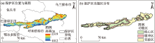
李全基. 内蒙古大青山国家级自然保护区综合科考集[M]. 北京: 中国林业出版社, 2014: 1-32.
|
|
[Li Quanji. Comprehensive scientific examination papers of Daqing Mountain National Nature Reserve in Inner Mongolia[M]. Beijing: China Forestry Publishing House, 2014: 1-32.]
|
| [14] |
张志强, 刘欢, 左其亭, 等. 2000—2019年黄河流域植被覆盖度时空变化[J]. 资源科学, 2021, 43(4): 849-858.
doi: 10.18402/resci.2021.04.18
|
|
[Zhang Zhiqiang, Liu Huan, Zuo Qiting, et al. Spatiotemporal change of fractional vegetation cover in the Yellow River Basin during 2000—2019[J]. Resources Science, 2021, 43(4): 849-858.]
doi: 10.18402/resci.2021.04.18
|
| [15] |
内政字(2019)19号. 内蒙古自治区人民政府关于内蒙古大青山国家级自然保护区范围和功能区界线校正控制点坐标的通告[S]. 呼和浩特, 2019.
|
|
[Internal Affairs (2019) No.19. Notice of the People’s Government of Inner Mongolia Autonomous Region on the coordinates of control points for correcting the boundaries of the scope and functional area of Daqingshan National Nature Neserve in Inner Mongolia[S]. Hohhot, 2019.]
|
| [16] |
王佳新, 毕哲睿, 王晓芳. 大青山国家级自然保护区保护工程效果研究——以呼和浩特市段为例[J]. 草原与草业, 2020, 32(4): 53-58.
|
|
[Wang Jiaxin, Bi Zherui, Wang Xiaofang. Effect of the protection project in Daqing Mountain National Nature Reserve: Taking Hohhot as an example[J]. Grassland and Prataculture, 2020, 32(4): 53-58.]
|
| [17] |
张华, 宋金岳, 李明, 等. 基于GEE的祁连山国家公园生态环境质量评价及成因分析[J]. 生态学杂志, 2021, 40(6): 1883-1894.
|
|
[Zhang Hua, Song Jinyue, Li Ming, et al. Eco-environmental quality assessment and cause analysis of Qilian Mountain National Park based on GEE[J]. Chinese Journal of Ecology, 2021, 40(6): 1883-1894.]
|
| [18] |
Roy D P, Kovalskyy V, Zhang H K, et al. Characterization of Landsat-7 to Landsat-8 reflective wavelength and normalized difference vegetation index continuity[J]. Remote Sensing of Environment, 2016, 185: 57-70.
doi: 10.1016/j.rse.2015.12.024
|
| [19] |
徐勇, 黄雯婷, 靖娟利, 等. 京津冀地区植被NDVI动态变化及其与气候因子的关系[J]. 水土保持通报, 2020, 40(5): 319-327.
|
|
[Xu Yong, Huang Wenting, Jing Juanli, et al. Dynamic variation of vegetation cover and its relation with climate variables in Beijing- Tianjin-Hebei region[J]. Buletin of Soil and Water Conservation, 2020, 40(5): 319-327.]
|
| [20] |
Yang J, Huang X. The 30 m annual land cover dataset and its dynamics in China from 1990 to 2019[J]. Earth System Science Data, 2021, 8(13): 3907-3925.
|
| [21] |
Sen P K. Estimates of the regression coefficient based on Kendall’s Tau[J]. Journal of the American Statistical Association, 2012, 63(324): 1379-1389.
doi: 10.1080/01621459.1968.10480934
|
| [22] |
王佃来, 刘文萍, 黄心渊. 基于Sen+Mann-Kendall的北京植被变化趋势分析[J]. 计算机工程与应用, 2013, 49(5): 13-17.
|
|
[Wang Dianlai, Liu Wenping, Huang Xinyuan. Trend analysis in vegetation cover in Beijing based on Sen+Mann-Kendall method[J]. Computer Engineering and Applications, 2013, 49(5): 13-17.]
|
| [23] |
赵文博, 冯莉莉, 赵安周, 等. 河北省2000—2017年荒漠化的时空演变及其气候驱动因子[J]. 水土保持通报, 2021, 41(4): 252-259.
|
|
[Zhao Wenbo, Feng Lili, Zhao Anzhou, et al. Spatial and temporal evolution of desertification and its driving factors of climate in Hebei Province[J]. Buletin of Soil and Water Conservation, 2021, 41(4): 252-259.]
|
| [24] |
张志高, 徐晓曼, 郭超凡, 等. 近61 a黄河流域霜冻日期时空分异特征及影响因素[J]. 干旱区地理, 2022, 45(6): 1685-1694.
|
|
[Zhang Zhigao, Xu Xiaoman, Guo Chaofan, et al. Spatial and temporal characteristics and influencing factors of frost date in the Yellow River Basin from 1960 to 2020[J]. Arid Land Geography, 2022, 45(6): 1685-1694.]
|
| [25] |
杜加强, 贾尔恒·阿哈提, 赵晨曦, 等. 1982—2012年新疆植被NDVI的动态变化及其对气候变化和人类活动的响应[J]. 应用生态学报, 2015, 26(12): 3567-3578.
pmid: 27111991
|
|
[Du Jiaqiang, Aheti Jiaerheng, Zhao Chenxi, et al. Dynamic changes in vegetation NDVI from 1982 to 2012 and its responses to climate change and human activities in Xinjiang, China[J]. Chinese Journal of Applied Ecology, 2015, 26(12): 3567-3578.]
pmid: 27111991
|
| [26] |
Cai H Y. Human-induced grassland degradation/restoration in the central Tibetan Plateau: The effects of ecological protection and restoration projects[J]. Ecological Engineering, 2015, 83: 112-119.
doi: 10.1016/j.ecoleng.2015.06.031
|
| [27] |
张乐艺, 李霞, 冯京辉, 等. 黄河流域NDVI时空变化及其对气候和人类活动的双重响应[J]. 水土保持通报, 2021, 41(5): 1-11.
|
|
[Zhang Leyi, Li Xia, Feng Jinghui, et al. Spatial-temporal changes of NDVI in Yellow River Basin and its dual response to climate change and human activities[J]. Bulletin of Soil and Water Conservation, 2021, 41(5): 1-11.]
|
| [28] |
顾锡羚, 郭恩亮, 银山, 等. 黄河引水工程对库布齐沙漠北缘植被的影响[J]. 生态学杂志, 2021, 40(9): 2678-2688.
|
|
[Gu Xiling, Guo Enliang, Yin Shan, et al. Influence of Yellow River Diversion Project on vegetation in the northern margin of Kubuqi Desert[J]. Chinese Journal of Ecology, 2021, 40(9): 2678-2688.]
|
| [29] |
Grömping U. Relative importance for linear regression in R: The package relaimpo[J]. Journal of Statistical Software, 2006, 17(1): 1-27.
|
| [30] |
Yao Y T, Wang X H, Li Y. Spatiotemporal pattern of gross primary productivity and its covariation with climate in China over the last thirty years[J]. Global Change Biology, 2018, 24(1): 184-196.
doi: 10.1111/gcb.13830
pmid: 28727222
|
| [31] |
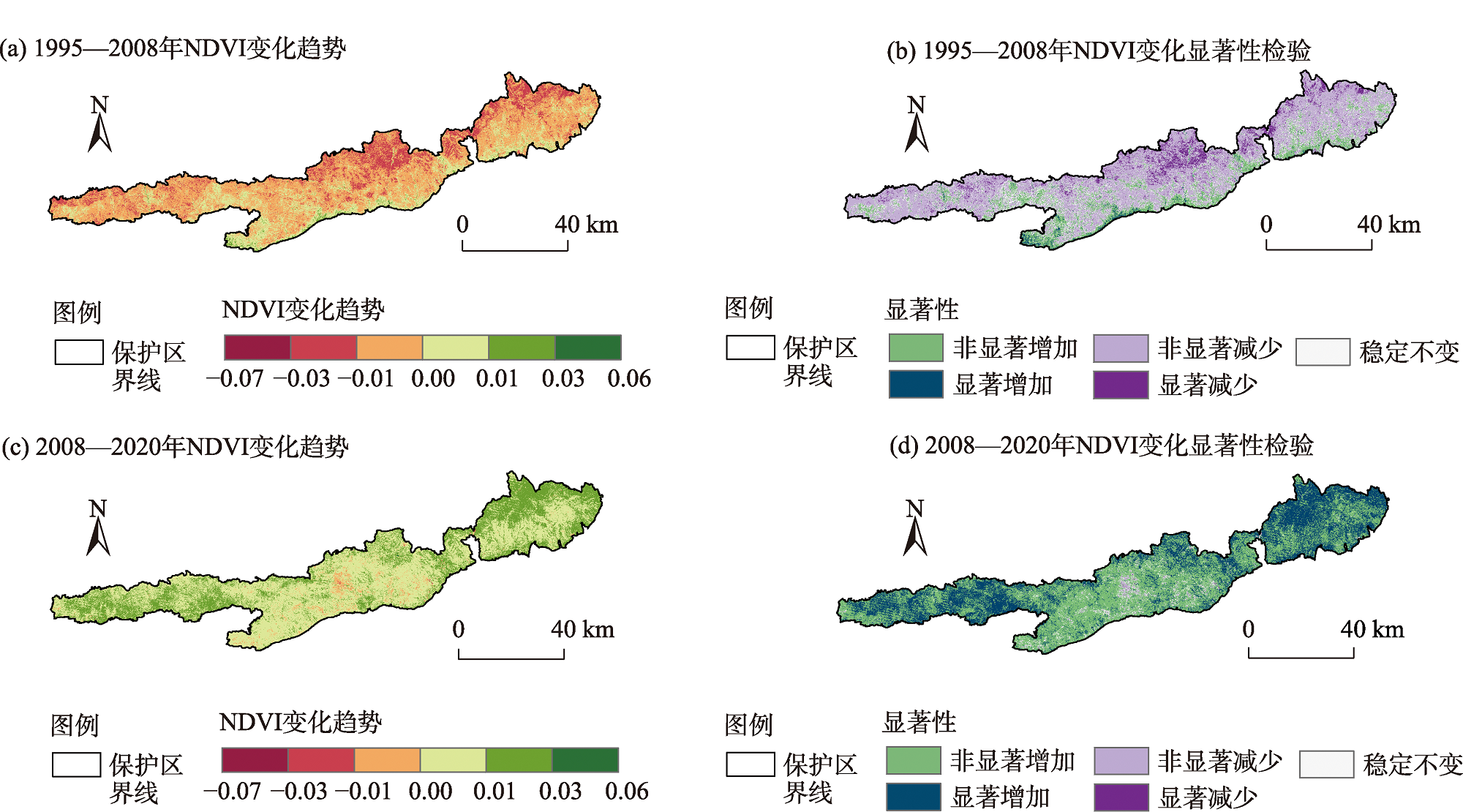
胡尔查, 王晓江, 铁牛, 等. 内蒙古大青山国家级自然保护区植被归一化指数时空变化及其与环境因子的关系[J]. 生态学报, 2022, 42(14): 5945-5955.
|
|
[Hu Ercha, Wang Xiaojiang, Tie Niu, et al. Spatio-temporal variation of NDVI and influencing factors in the Daqing Mountain National Nature Reserve, Inner Mongolia[J]. Acta Ecologica Sinica, 2022, 42(14): 5945-5955.]
|
| [32] |
Li C J, Fu B J, Wang S, et al. Drivers and impacts of changes in China’s drylands[J]. Nature Reviews Earth and Environment, 2021, 2: 858-873.
doi: 10.1038/s43017-021-00226-z
|
| [33] |
呼林草办发〔2022〕15号. 呼和浩特市林业和草原局关于印发《呼和浩特市大青山林草生态综合治理工作方案》的通知[Z]. 呼和浩特: 呼和浩特市林业和草原局, 2022.
|
|
[Hohhot Forestry and Grassland Administration [2022] No.15. Work plan for comprehensive management of forest and grass ecology in Daqing Mountain of Hohhot[Z]. Hohhot: Hohhot Forestry and Grassland Administration, 2022.]
|
| [34] |
Fang Z, Ding T H, Chen J Y, et al. Impacts of land use/land cover changes on ecosystem services in ecologically fragile regions[J]. Science of the Total Environment, 2022, 831: 154967, doi: 10.1016/j.scitotenv.2022.154967.
doi: 10.1016/j.scitotenv.2022.154967
|
| [35] |
邵全琴, 樊江文, 刘纪远, 等. 基于目标的三江源生态保护和建设一期工程生态成效评估[J]. 地理学报, 2016, 71(1): 3-20.
doi: 10.11821/dlxb201601001
|
|
[Shao Quanqin, Fan Jiangwen, Liu Jiyuan, et al. Assessment on the effects of the first-stage ecological conservationand restoration project in Sanjiangyuan region[J]. Acta Geographica Sinica, 2016, 71(1): 3-20.]
doi: 10.11821/dlxb201601001
|
| [36] |
郑虹钰. 内蒙古大青山国家级自然保护区资源现状与保护区价值分析[J]. 内蒙古林业调查设计, 2019, 42(3): 20-23, 26.
|
|
[Zheng Hongyu. Resource status and value analysis of Daqing Mountain National Nature Reserve, Inner Mongolia[J]. Inner Mongolia Forestry Investigation and Design, 2019, 42(3): 20-23, 26.]
|
| [37] |
贾丹阳, 熊祯祯, 高岩, 等. 近30 a台特玛湖地区土地利用/土地覆被变化及其影响因素[J]. 干旱区地理, 2021, 44(4): 1022-1031.
|
|
[Jia Danyang, Xiong Zhenzhen, Gao Yan, et al. Land use/land cover change and influencing factors in the Taitema Lake in the past 30 years[J]. Arid Land Geography, 2021, 44(4): 1022-1031.]
|
 ),王永芳1,2,3(