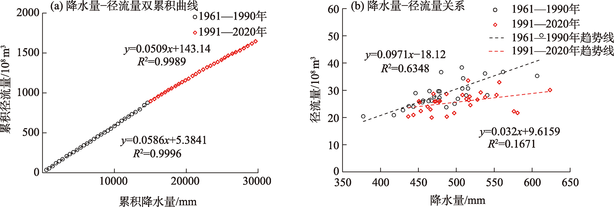
| [1] |
张建云, 王国庆. 河川径流变化及归因定量识别[M]. 北京: 科学出版社, 2014.
|
|
[ Zhang Jianyun, Wang Guoqing. Quantitative identification of river runoff change and attribution[M]. Beijing: Science Press, 2014. ]
|
| [2] |
杜嘉妮, 蔡宜晴, 刘希胜, 等. 基于Budyko假设的湟水径流变化归因识别[J]. 中国农村水利水电, 2022(7): 116-121.
|
|
[ Du Jiani, Cai Yiqing, Liu Xisheng, et al. Attribution analysis of runoff in the Huangshui River based on the Budyko hypothesis[J]. China Rural Water and Hydropower, 2022(7): 116-121. ]
|
| [3] |
吴恒卿, 刘赛艳, 黄强, 等. 基于SWAT模型的大通河流域径流模拟[J]. 西北农林科技大学学报(自然科学版), 2015, 43(9): 210-216.
|
|
[ Wu Hengqing, Liu Saiyan, Huang Qiang, et al. SWAT model based runoff simulation of Datong River Basin[J]. Journal of Northwest A & F University (Natural Science Edition), 2015, 43(9): 210-216. ]
|
| [4] |
白雁翎, 王芳, 刘扬. 大通河上游径流演变及驱动因素定量分析[J]. 南水北调与水利科技, 2021, 19(1): 103-110, 167.
|
|
[ Bai Yanling, Wang Fang, Liu Yang. Quantitative analysis of runoff evolution and driving factors in the upper reaches of Datong River[J]. South-to-North Water Transfers and Water Science & Technology, 2021, 19(1): 103-110, 167. ]
|
| [5] |
王大超. 大通河径流变化特征及其影响因素探析[D]. 兰州: 兰州大学, 2019.
|
|
[ Wang Dachao. Runoff variation characteristics for Datong River and its influencing factors[D]. Lanzhou: Lanzhou University, 2019. ]
|
| [6] |
张成凤, 刘翠善, 王国庆, 等. 基于Budyko假设的黄河源区径流变化归因识别[J]. 中国农村水利水电, 2020(9): 90-94.
|
|
[ Zhang Chengfeng, Liu Cuishan, Wang Guoqing, et al. Attribution of runoff variation for the Yellow River source region based on the Budyko hypothesis[J]. China Rural Water and Hydropower, 2020(9): 90-94. ]
|
| [7] |
王随继, 闫云霞, 颜明, 等. 皇甫川流域降水和人类活动对径流量变化的贡献率分析——累积量斜率变化率比较方法的提出及应用[J]. 地理学报, 2012, 67(3): 388-397.
doi: 10.11821/xb201203010
|
|
[ Wang Suiji, Yan Yunxia, Yan Ming, et al. Contributions of precipitation and human activities to the runoff change of the Huangfuchuan Drainage Basin: Application of comparative method of the slope changing ratio of cumulative quantity[J]. Acta Geographica Sinica, 2012, 67(3): 388-397. ]
doi: 10.11821/xb201203010
|
| [8] |
郭爱军, 畅建霞, 黄强, 等. 渭河流域气候变化与人类活动对径流影响的定量分析[J]. 西北农林科技大学学报(自然科学版), 2014, 42(8): 212-220.
|
|
[ Guo Aijun, Chang Jianxia, Huang Qiang, et al. Quantitative analysis of the impacts of climate change and human activities on runoff change in Weihe Basin[J]. Journal of Northwest A & F University (Natural Science Edition), 2014, 42(8): 212-220. ]
|
| [9] |
李佳, 汪赢政, 李建江. 祁连山地区冰川边界产品(1980—2015)[DB]. 国家青藏高原科学数据中心, https://doi.org/10.11888/Geogra.tpdc.270234.
|
|
[ Li Jia, Wang Yingzheng, Li Jianjiang. Glacier outlines over the Qilian Mountain area (1980—2015)[DB]. National Tibetan Plateau/Third Pole Environment Data Center, https://doi.org/10.11888/Geogra.tpdc.270234. ]
|
| [10] |
仲波, 吴俊君. 祁连山区域基于Landsat 反射率数据的月度30 m×30 m地表植被指数数据(1986—2017)[DB]. 国家青藏高原科学数据中心, https://doi.org/10.1188/Geogra.tpdc.270136.
|
|
[ Zhong Bo, Wu Junjun. Landsat-based continuous monthly 30 m×30 m land surface NDVI dataset in Qilian Mountain area (1986—2017)[DB]. National Tibetan Plateau/Third Pole Environment Data Center, https://doi.org/10.1188/Geogra.tpdc.270136. ]
|
| [11] |
GB/T20481-2017. 中华人民共和国国家标准: 气象干旱等级[S]. 北京: 中国标准出版社, 2017.
|
|
GB/T20481-2017. National Standard of the People’s Republic of China: Grades of meteorological drought[S]. Beijing: Standard Press of China, 2017. ]
|
| [12] |
魏凤英. 现代气候统计诊断与预测技术[M]. 北京: 气象出版社, 2007.
|
|
[ Wei Fengying. Modern technology of statistics, diagnosis and forecast for climate[M]. Beijing: China Meteorological Press, 2007. ]
|
| [13] |
黄强, 黄生志, 潘晶晶. 水文序列变异诊断理论与方法[M]. 北京: 科学出版社, 2020.
|
|
[ Huang Qiang, Huang Shengzhi, Pan Jingjing. Theory and methods of hydrological sequence variation diagnosis[M]. Beijing: Science Press, 2020. ]
|
| [14] |
成艺, 武兰珍, 刘峰贵, 等. 黄河上游近60 a径流量与降水量变化特征研究[J]. 干旱区地理, 2022, 45(4): 1022-1031.
|
|
[ Cheng Yi, Wu Lanzhen, Liu Fenggui, et al. Changes of runoff and precipitation in the upstream of Yellow River during the past 60 years[J]. Arid Land Geography, 2022, 45(4): 1022-1031. ]
|
| [15] |
蔡宜晴, 李文辉, 于泽兴, 等. 长江源区降水时空演变规律[J]. 长江科学院院报, 2022, 39(5): 28-35.
doi: 10.11988/ckyyb.20210013
|
|
[ Cai Yiqing, Li Wenhui, Yu Zexing, et al. Temporal and spatial evolution of precipitation in the headwaters of the Yangtze River[J]. Journal of Yangtze River Scientific Research Institute, 2022, 39(5): 28-35. ]
doi: 10.11988/ckyyb.20210013
|
| [16] |
杨阳, 时璐, 刘弢, 等. 青海省西北诸河61 a来降水演变特征及空间分布研究[J]. 中国农村水利水电, 2020(8): 159-165.
|
|
[ Yang Yang, Shi Lu, Liu Tao, et al. The evolution characteristics and spatial distribution of precipitation in northwest region of Qinghai in recent 61 years[J]. China Rural Water and Hydropower, 2020(8): 159-165. ]
|
| [17] |
刘宇, 管子隆, 田济扬, 等. 近70 a泾河流域径流变化及其驱动因素研究[J]. 干旱区地理, 2022, 45(1): 17-26.
|
|
[ Liu Yu, Guan Zilong, Tian Jiyang, et al. Runoff change and its driving factors in Jinghe River Basin in recent 70 years[J]. Arid Land Geography, 2022, 45(1): 17-26. ]
|
| [18] |
穆兴民, 张秀勤, 高鹏, 等. 双累积曲线方法理论及在水文气象领域应用中应注意的问题[J]. 水文, 2010, 30(4): 47-51.
|
|
[ Mu Xingming, Zhang Xiuqing, Gao Peng, et al. Theory of double mass curves and its applications in hydrology and meteorology[J]. Chinese Journal of Hydrological, 2010, 30(4): 47-51. ]
|
| [19] |
关颖慧, 王淑芝, 温得平. 长江源区水沙变化特征及成因分析[J]. 泥沙研究, 2021, 46(3): 43-49, 56.
|
|
[ Guan Yinghui, Wang Shuzhi, Wen Deping. Variations and cause analysis of runoff and sediment load in the source regions of Yangtze River[J]. Journal of Sediment Research, 2021, 46(3): 43-49, 56. ]
|
| [20] |
Alexander L V, Allen S K, Bindoff N L, et al. Summary for policymakers[M]// IPCC. Climate Change 2013: The Physical Science Basis. Cambridge: Cambridge University Press, 2013.
|
| [21] |
杨大文, 张树磊, 徐翔宇. 基于水热耦合平衡方程的黄河流域径流变化归因分析[J]. 中国科学: 技术科学, 2015, 45(10): 1024-1034.
|
|
[ Yang Dawen, Zhang Shulei, Xu Xiangyu. Attribution analysis for runoff decline in Yellow River Basin during past fifty years based on Budyko hypothesis[J]. Scientia Sinica Technologica, 2015, 45(10): 1024-1034. ]
doi: 10.1360/N092015-00013
|
 ), 温得平2(