- Jul. 29, 2025
Arid Land Geography ›› 2021, Vol. 44 ›› Issue (4): 1032-1044.doi: 10.12118/j.issn.1000–6060.2021.04.16
• Earth Surface Process • Previous Articles Next Articles
YANG Xiaoying1( ),Yu Shan1,2(),Du Wala3,Hong Mei1
Received:2020-06-22
Revised:2021-03-05
Online:2021-07-25
Published:2021-08-02
Contact:
Shan Yu
E-mail:1595953596@qq.com;yushangis@163.com
YANG Xiaoying,Yu Shan,Du Wala,Hong Mei. Risk assessment of grassland fire on the Mongolian Plateau[J].Arid Land Geography, 2021, 44(4): 1032-1044.
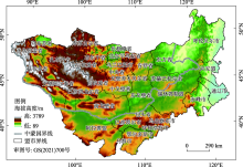
Fig. 1
Location of the study area"

Tab. 1
Risk assessment index system and weight of grassland fire on the Mongolian Plateau"
| 目标层 | 因子(权重) | 次因子 | 指标 | 指标权重 |
|---|---|---|---|---|
| 草原火灾 风险综合指标 | 危险性(0.3287) | 火源 | 人口密度/人·km-2 | 0.0460 |
| 可燃物特征 | 可燃物量 | 0.0584 | ||
| 气象条件 | 月均最高气温/℃ | 0.0431 | ||
| 月均最大风速/m·s-1 | 0.0560 | |||
| 月降水量/mm | 0.0730 | |||
| 积雪面积/m2 | 0.0068 | |||
| 地形环境 | 高程/m | 0.0225 | ||
| 坡度/(°) | 0.0193 | |||
| 坡向 | 0.0036 | |||
| 暴露性(0.2224) | 生命暴露性 | 人口数量/人 | 0.0609 | |
| 牲畜数量/头 | 0.0460 | |||
| 经济暴露性 | 地区生产总值/元 | 0.0618 | ||
| 建筑物数量/间 | 0.0537 | |||
| 脆弱性(0.2548) | 生命脆弱性 | 非劳动人口数/人 | 0.0494 | |
| 幼畜数量/头 | 0.0494 | |||
| 可燃物类型 | 0.0540 | |||
| 经济脆弱性 | 牧业产值占GDP比值/% | 0.0540 | ||
| 人均GDP/元·人-1 | 0.0480 | |||
| 防灾减灾能力(0.1941) | 防火条件 | 防火人员数量/人 | 0.0506 | |
| 防火设备数量/套 | 0.0009 | |||
| 防火资金投入/元 | 0.0543 | |||
| 防火隔离带/条 | 0.0570 | |||
| 交通条件 | 道路密度/km·km-2 | 0.0312 |
Tab. 2
Principal component analysis of each indicator"
| 主成分 | 初始特征值 | 提取平方和载入 | ||||
|---|---|---|---|---|---|---|
| 合计 | 方差/% | 累积/% | 合计 | 方差/% | 累积/% | |
| 1 | 9.584 | 41.672 | 41.672 | 9.584 | 41.672 | 41.672 |
| 2 | 3.395 | 14.760 | 56.432 | 3.395 | 14.760 | 56.432 |
| 3 | 2.002 | 8.703 | 65.135 | 2.002 | 8.703 | 65.135 |
| 4 | 1.440 | 6.259 | 71.394 | 1.440 | 6.259 | 71.394 |
| 5 | 1.250 | 5.436 | 76.830 | 1.250 | 5.436 | 76.830 |
| 6 | 1.172 | 5.095 | 81.925 | 1.172 | 5.095 | 81.925 |
| 7 | 1.018 | 4.425 | 86.350 | 1.018 | 4.425 | 86.350 |
| 8 | 0.759 | 3.300 | 89.650 | - | - | - |
| 9 | 0.540 | 2.347 | 91.996 | - | - | - |
| 10 | 0.466 | 2.028 | 94.024 | - | - | - |
| 11 | 0.331 | 1.439 | 95.463 | - | - | - |
| 12 | 0.283 | 1.229 | 96.693 | - | - | - |
| 13 | 0.203 | 0.882 | 97.574 | - | - | - |
| 14 | 0.153 | 0.665 | 98.240 | - | - | - |
| 15 | 0.120 | 0.520 | 98.760 | - | - | - |
| 16 | 0.082 | 0.358 | 99.118 | - | - | - |
| 17 | 0.070 | 0.306 | 99.424 | - | - | - |
| 18 | 0.060 | 0.261 | 99.686 | - | - | - |
| 19 | 0.030 | 0.130 | 99.816 | - | - | - |
| 20 | 0.024 | 0.106 | 99.922 | - | - | - |
| 21 | 0.012 | 0.054 | 99.976 | - | - | - |
| 22 | 0.006 | 0.024 | 100.000 | - | - | - |
| 23 | 0.000 | 0.000 | 100.000 | - | - | - |
Tab. 3
Initial factor load matrix of each indicator"
| 指标 | 成分矩阵 | ||||||
|---|---|---|---|---|---|---|---|
| 1 | 2 | 3 | 4 | 5 | 6 | 7 | |
| 人口密度 | 0.283 | -0.078 | 0.783 | 0.193 | -0.088 | -0.084 | 0.263 |
| 可燃物量 | 0.396 | 0.871 | 0.025 | -0.056 | -0.101 | -0.089 | 0.137 |
| 月均最高气温 | -0.759 | -0.163 | 0.211 | 0.043 | 0.020 | -0.108 | 0.379 |
| 月均最大风速 | -0.926 | 0.088 | -0.080 | 0.149 | -0.065 | 0.063 | 0.028 |
| 月降水量 | 0.596 | 0.700 | 0.058 | 0.027 | 0.088 | -0.089 | 0.153 |
| 积雪面积 | -0.311 | 0.674 | 0.214 | -0.173 | -0.281 | 0.371 | -0.145 |
| 高程 | -0.622 | -0.092 | -0.026 | 0.602 | -0.019 | 0.405 | -0.058 |
| 坡度 | -0.330 | 0.609 | -0.011 | 0.480 | -0.138 | 0.381 | -0.019 |
| 坡向 | -0.443 | 0.125 | 0.338 | -0.065 | 0.637 | -0.075 | 0.277 |
| 人口数量 | 0.898 | -0.011 | -0.109 | 0.196 | -0.108 | -0.064 | 0.191 |
| 牲畜数量 | 0.851 | -0.071 | -0.340 | -0.151 | 0.021 | 0.181 | 0.086 |
| 地区生产总值 | 0.804 | -0.250 | 0.016 | 0.278 | 0.132 | 0.217 | 0.116 |
| 建筑物数量 | 0.717 | -0.158 | 0.060 | 0.501 | -0.065 | -0.099 | 0.070 |
| 非劳动人口数 | 0.819 | 0.013 | -0.212 | 0.107 | -0.162 | -0.091 | 0.196 |
| 幼畜数量 | 0.600 | 0.049 | 0.188 | 0.407 | 0.199 | -0.248 | -0.346 |
| 可燃物类型 | 0.389 | 0.852 | -0.065 | -0.035 | -0.093 | -0.165 | 0.163 |
| 牧业产值占GDP比值 | -0.717 | 0.075 | -0.458 | 0.154 | 0.222 | -0.136 | -0.076 |
| 人均GDP | 0.775 | -0.407 | 0.321 | 0.036 | -0.004 | 0.135 | -0.049 |
| 防火人员数量 | 0.623 | -0.113 | -0.252 | -0.143 | 0.258 | 0.460 | 0.381 |
| 防火设备数量 | 0.578 | -0.372 | -0.148 | -0.127 | -0.505 | -0.065 | -0.065 |
| 防火资金投入 | 0.692 | 0.320 | -0.030 | 0.101 | 0.311 | -0.208 | -0.394 |
| 防火隔离带 | 0.721 | 0.104 | -0.097 | -0.183 | 0.369 | 0.379 | -0.226 |
| 道路密度 | 0.256 | -0.006 | 0.740 | -0.270 | -0.058 | 0.225 | -0.223 |
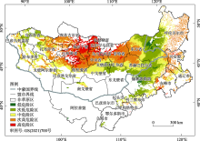
Fig. 2
Hazard distribution of grassland fire on the Mongolian Plateau"


Fig. 3
Exposure distribution of grassland fire on the Mongolian Plateau"
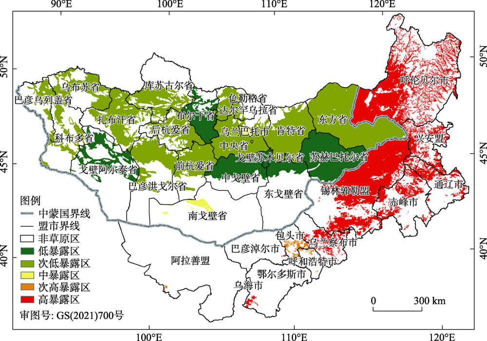
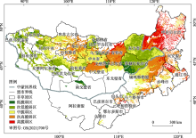
Fig. 4
Vulnerability distribution of grassland fire on the Mongolian Plateau"

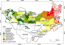
Fig. 5
Distribution of grassland fire disaster prevention and mitigation on the Mongolian Plateau"

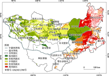
Fig. 6
Comprehensive risk distribution of grassland fire on the Mongolian Plateau"

| [1] | 崔亮. 内蒙古呼伦贝尔草原火灾风险预警研究[D]. 长春: 东北师范大学, 2011. |
| [ Cui Liang. A study on early warning of grassland fire disaster risk in Hulunbeier of Inner Mongolia[D]. Changchun: Northeast Normal University, 2011. ] | |
| [2] |
Johnston L M, Wang X, Erni S, et al. Wildland fire risk research in Canada[J]. Environmental Reviews, 2020, 28(2):164-186.
doi: 10.1139/er-2019-0046 |
| [3] | 姜莉, 玉山, 乌兰图雅, 等. 草原火研究综述[J]. 草地学报, 2018, 26(4):4-16. |
| [ Jiang Li, Yushan, Wulantuya, et al. Summary of grassland fire research[J]. Acta Agrestia Sinica, 2018, 26(4):4-16. ] | |
| [4] | 曲炤鹏, 郑淑霞, 白永飞, 等. 蒙古高原草原火行为的时空格局与影响因子[J]. 应用生态学报, 2010, 21(4):807-813. |
| [ Qu Chaopeng, Zheng Suxia, Bai Yongfei, et al. Spatiotemporal patterns and driving factors of grassland fire on Mongolian Plateau[J]. Chinese Journal of Applied Ecology, 2010, 21(4):807-813. ] | |
| [5] |
Rasooli S B, Bonyad A E. Evaluating the efficiency of the Dong model in determining fire vulnerability in Iran’s Zagros Forests[J]. Journal of Forestry Research, 2019, 30(4):1447-1458.
doi: 10.1007/s11676-018-0765-8 |
| [6] | 萨如拉, 张鑫, 韩霄, 等. 1981—2015年内蒙古自治区草原火灾时空动态研究[J]. 消防科学与技术, 2019, 38(3):421-425. |
| [ Sarula, Zhang Xin, Han Xiao, et al. Studies on the temporal and spatial dynamics of grassland fires in Inner Mongolia from 1981 to 2015[J]. Fire Science and Technology, 2019, 38(3):421-425. ] | |
| [7] |
Liu X P, Zhang G Q, Lu J, et al. Risk assessment using transfer learning for grassland fires[J]. Agricultural and Forest Meteorology, 2019, 269-270:102-111.
doi: 10.1016/j.agrformet.2019.01.011 |
| [8] | 杨光, 腾跃, 舒立福, 等. “一带一路”沿线区域森林草原防火概述[J]. 世界林业研究, 2018, 31(6):82-88. |
| [ Yang Guang, Teng Yue, Shu Lifu, et al. Review of forest and grassland fire prevention along “the Belt and Road”[J]. World Forestry Research, 2018, 31(6):82-88. ] | |
| [9] | 杨存建, 冯凉, 杨洪忠, 等. 四川省林草火险等级评价[J]. 地理研究, 2010, 29(6):980-988. |
| [ Yang Cunjian, Feng Liang, Yang Hongzhong, et al. Study of evaluation of forest and grass fire risk grade in Sichuan Province[J]. Geographical Research, 2010, 29(6):980-988. ] | |
| [10] | 王卫国, 潘竟虎, 李俊峰. 基于空间Logistic的山西省火灾风险评价与火险区划[J]. 草业科学, 2016, 33(4):635-644. |
| [ Wang Weiguo, Pan Jinghu, Li Junfeng. Assessment and zoning of fire risk in Shanxi Province based on spatial Logistic model[J]. Pratacultural Science, 2016, 33(4):635-644. ] | |
| [11] |
Benguerai A, Benabdeli K, Harizia A. Forest fire risk assessment model using remote sensing and GIS techniques in northwest Algeria[J]. Acta Silvatica et Lignaria Hungarica, 2019, 15(1):9-21.
doi: 10.2478/aslh-2019-0001 |
| [12] | 慕臣英, 徐全辉, 张菁, 等. RS和GIS技术在沈阳市火灾监测中的应用研究[J]. 中国农学通报, 2016, 32(9):179-182. |
| [ Mu Chenying, Xu Quanhui, Zhang Jing, et al. Application of RS and GIS in fire disaster monitoring in Shenyang[J]. Chinese Agricultural Science Bulletin, 2016, 32(9):179-182. ] | |
| [13] |
Maselli F, Rodolfi A, Bottai L, et al. Classification of Mediterranean vegetation by TM and ancillary data for the evaluation of fire risk[J]. International Journal of Remote Sensing, 2000, 21(17):3303-3313.
doi: 10.1080/014311600750019912 |
| [14] |
Eugenio F C, Santos A R D, Fiedler N C, et al. Applying GIS to develop a model for forest fire risk: A case study in Espírito Santo, Brazil[J]. Journal of Environmental Management, 2016, 173(15):65-71.
doi: 10.1016/j.jenvman.2016.02.021 |
| [15] |
Naderpour M, Rizeei H M, Khakzad N, et al. Forest fire induced Natech risk assessment: A survey of geospatial technologies[J]. Reliability Engineering and System Safety, 2019, 191:106558, doi: 10.1016/j.ress.2019.106558.
doi: 10.1016/j.ress.2019.106558 |
| [16] |
Adab H, Kanniah K D, Solaimani K. Modeling forest fire risk in the northeast of Iran using remote sensing and GIS techniques[J]. Natural Hazards, 2013, 65(3):1723-1743.
doi: 10.1007/s11069-012-0450-8 |
| [17] | 张继权, 刘兴朋, 佟志军, 等. 草原火灾风险评价与分区——以吉林省西部草原为例[J]. 地理研究, 2007, 26(4):755-762. |
| [ Zhang Jiquan, Liu Xingpeng, Tong Zhijun, et al. The study of grassland fire disaster risk assessment and regionalization: A case study in the western Jilin Province[J]. Geographical Research, 2007, 26(4):755-762. ] | |
| [18] |
Laxmi K S, Shruti K, Mahendra S N, et al. Fuzzy AHP for forest fire risk modeling[J]. Disaster Prevention and Management, 2012, 21(2):160-171.
doi: 10.1108/09653561211219964 |
| [19] |
Bian H F, Zhang H Y, Zhou D W, et al. Integrating models to evaluate and map grassland fire risk zones in Hulunbuir of Inner Mongolia, China[J]. Fire Safety Journal, 2013, 61:207-216.
doi: 10.1016/j.firesaf.2013.09.004 |
| [20] | 张继权, 刘兴朋. 基于信息扩散理论的吉林省草原火灾风险评价[J]. 干旱区地理, 2007, 30(4):590-594. |
| [ Zhang Jiquan, Liu Xingpeng. Risk assessment of grassland fire in Jilin Province based on information diffusion theory[J]. Arid Land Geography, 2007, 30(4):590-594. ] | |
| [21] | 丽娜, 包玉龙, 银山, 等. 中蒙边境地区草原火时空分布特征分析[J]. 灾害学, 2016, 31(3):207-210. |
| [ Lina, Bao Yulong, Yinshan, et al. Spatiotemporal characteristics of grassland fire in China-Mongolia border area[J]. Journal of Catastrophology, 2016, 31(3):207-210. ] | |
| [22] | 陈鹏宇, 赵凤君, 舒立福, 等. 蒙古森林草原火灾状况及林火管理[J]. 世界林业研究, 2014, 27(2):66-69. |
| [ Chen Pengyu, Zhao Fengjun, Shu Lifu, et al. Fires and fire management on forest steppe in Mongolian[J]. World Forestry Research, 2014, 27(2):66-69. ] | |
| [23] | 姜康, 包刚, 乌兰图雅, 等. 基于MODIS数据的蒙古高原积雪时空变化研究[J]. 干旱区地理, 2019, 42(4):782-789. |
| [ Jiang Kang, Bao Gang, Wulantuya, et al. Spatiotemporal changes of snow cover in Mongolian Plateau based on MODIS data[J]. Arid Land Geography, 2019, 42(4):782-789. ] | |
| [24] | 张艳珍, 王钊齐, 杨悦, 等. 蒙古高原草地退化程度时空分布定量研究[J]. 草业科学, 2018, 35(2):233-243. |
| [ Zhang Yanzhen, Wang Zhaoqi, Yang Yue, et al. Research on the quantitative evaluation of grassland degradation and spatial and temporal distribution on the Mongolia Plateau[J]. Pratacultural Science, 2018, 35(2):233-243. ] | |
| [25] |
包刚, 包玉海, 覃志豪, 等. 近10年蒙古高原植被覆盖变化及其对气候的季节响应[J]. 地理科学, 2013, 33(5):613-621.
doi: 10.13249/j.cnki.sgs.2013.05.613 |
|
[ Bao Gang, Bao Yuhai, Qin Zhihao, et al. Vegetation cover changes in Mongolian Plateau and its responseto seasonal climate changes in recent 10 years[J]. Scientia Geographica Sinica, 2013, 33(5):613-621. ]
doi: 10.13249/j.cnki.sgs.2013.05.613 |
|
| [26] | 韩群柱, 冯起, 高海东, 等. 基于主成分分析的关中地区农业粮食生产变化的影响因素研究[J]. 干旱区地理, 2020, 43(2):474-480. |
| [ Han Qunzhu, Feng Qi, Gao Haidong, et al. Influencing factors of agricultural production changes in Guanzhong based on PCA[J]. Arid Land Geography, 2020, 43(2):474-480. ] | |
| [27] | 徐玉霞, 许小明, 方锋, 等. 县域尺度下的宝鸡市农业洪水灾害脆弱性评价及区划[J]. 干旱区地理, 2020, 43(3):652-660. |
| [ Xu Yuxia, Xu Xiaoming, Fang Feng, et al. Assessment and zoning of vulnerability of agricultural flood diaster in Baoji City based on county scale[J]. Arid Land Geography, 2020, 43(3):652-660. ] | |
| [28] | 王啟德, 闫德民, 郭宇, 等. 内蒙古草原火灾发生规律及影响因素研究[J]. 森林防火, 2019(3):38-42. |
| [ Wang Qide, Yan Demin, Guo Yu, et al. Study on the occurrence law and influencing factors of grassland fire in Inner Mongolia[J]. Forest Fire Prevention, 2019(3):38-42. ] | |
| [29] | 陈帅, 陶骏骏, 王振师, 等. 火行为对森林地表可燃物燃烧碳转化的影响[J]. 燃烧科学与技术, 2018, 24(2):177-185. |
| [ Chen Shuai, Tao Junjun, Wang Zhenshi, et al. Effects of fire behavior on carbon conversion rates of surface fire in wildland[J]. Journal of Combustion Science and Technology, 2018, 24(2):177-185. ] | |
| [30] | 刘柯珍. 大兴安岭地区夏季火环境及林火发生预报模型研究[D]. 北京: 中国林业科学研究院, 2018. |
| [ Liu Kezhen. Fire environment and forecasting models of summer forest fire in Daxing’an Mountain district[D]. Beijing: Chinese Academy of Forestry Sciences, 2018. ] | |
| [31] | 红英. 积雪对草原火发生的影响研究[D]. 长春: 东北师范大学, 2016. |
| [ Hong Ying. Study the effecting of snow distribution on grassland fire occurrence[D]. Changchun: Northeast Normal University, 2016. ] | |
| [32] | 刘丹, 于成龙. 气候变化对东北主要地带性植被类型分布的影响[J]. 生态学报, 2017, 37(19):6511-6522. |
| [ Liu Dan, Yu Chenglong. Effects of climate change on the distribution of major zonal vegetation types in northeast China[J]. Acta Ecologica Sinica, 2017, 37(19):6511-6522. ] | |
| [33] |
Paveglio T B, Edgeley C M, Stasiewicz A M. Assessing influences on social vulnerability to wildfire using surveys, spatial data and wildfire simulations[J]. Journal of Environmental Management, 2018, 213:425-439.
doi: S0301-4797(18)30175-0 pmid: 29505998 |
| [34] | 曹丽娟, 张小平. 基于主成分分析的甘肃省水资源承载力评价[J]. 干旱区地理, 2017, 40(4):906-912. |
| [ Cao Lijuan, Zhang Xiaoping. Assessment of water resources carrying capacity in Gansu Province based on principal component analysis[J]. Arid Land Geography, 2017, 40(4):906-912. ] | |
| [35] | 温都日娜. 基于MODIS数据的蒙古高原植被覆盖变化及其对水热条件的响应[D]. 呼和浩特: 内蒙古师范大学, 2017. |
| [ Wendurina. Research on spatiotemporal changes of vegetation cover and its response to hydrothermal conditions in the Mongolian Plateau using MODIS data[D]. Hohhot: Inner Mongolia Normal University, 2017. ] | |
| [36] |
Wu R H, Zhao J J, Zhang H Y, et al. Wildfires on the Mongolian Plateau: Identifying drivers and spatial distributions to predict wildfire probability[J]. Remote Sensing, 2019, 11(20):2361, doi: 10.3390/rs11202361.
doi: 10.3390/rs11202361 |
| [37] | 都瓦拉. 内蒙古草原火灾监测预警及评价研究[D]. 北京: 中国农业科学院, 2012. |
| [ Duwala. A study of grassland fire monitoring and early warning and assessment Inner Mongolia[D]. Beijing: Chinese Academy of Agricultural Sciences, 2012. ] | |
| [38] |
Liu X, Zhang J, Cai W, et al. Information diffusion-based spatio-temporal risk analysis of grassland fire disaster in northern China[J]. Knowledge-Based Systems, 2010, 23(1):53-60.
doi: 10.1016/j.knosys.2009.07.002 |
| [1] | SHI Weiliang, CHE Luyang, LI Tao. Probability distribution and comprehensive risk assessment of extreme precipitation in flood season in Shaanxi Province [J]. Arid Land Geography, 2023, 46(9): 1407-1417. |
| [2] | LI Lele, CHAO Jinlong, ZHAO Deyi, LI Haojie, WU Lindong, LI Jiajun. Spatiotemporal distribution characteristics of rainstorm and risk assessment of rainstorm disasters in Shanxi Province from 1957 to 2019 [J]. Arid Land Geography, 2023, 46(5): 689-699. |
| [3] | ZHANG Gangdong, BAO Gang, YUAN Zhihui, WEN Durina. Effects of asymmetric warming of daytime and nighttime on the start of growing season on the Mongolian Plateau from 2001 to 2020 [J]. Arid Land Geography, 2023, 46(5): 700-710. |
| [4] | PAN Xue, GUAN Yuqi, PAN Zhandong, LIU Jie, CAI Liqun, DONG Bo, DU Jian. Spatiotemporal variation and evaluation of cultivated land quality grade in arid areas: A case of Xining City [J]. Arid Land Geography, 2023, 46(5): 793-803. |
| [5] | LUO Rongji, WANG Hongtao, WANG Cheng. Ecological quality evaluation of Gulang County in Gansu Province based on improved remote sensing ecological index [J]. Arid Land Geography, 2023, 46(4): 539-549. |
| [6] | WU Yingying,WANG Zhenting. Risk assessment of soil wind erosion in Hetao Plain [J]. Arid Land Geography, 2023, 46(3): 418-427. |
| [7] | GAO Yanzhe, Alatengtuya , TAN Na, Aorigele . Lake changes and their influence factors in the Mongolian Plateau from 2000 to 2020 [J]. Arid Land Geography, 2023, 46(2): 191-200. |
| [8] | ZHANG Sarilang, Wulantuya , Buhe , Yongmei , Siqinchaoketu , ZHANG Weiqing. Bibliometric analysis of land desertification research on the Mongolian Plateau in recent 40 years [J]. Arid Land Geography, 2023, 46(12): 1984-1994. |
| [9] | JIANG Lei, LIU Xiaolong, GUO Shuai, HE Liang, XING Jianlei, GUO Junjie. Evaluation of soil salinization susceptibility based on Logistic regression analysis: A case of Tarim irrigation area in southern Xinjiang [J]. Arid Land Geography, 2023, 46(11): 1858-1867. |
| [10] | XIE Conghui,WU Shixin,LIN Juan,ZHUANG Qingwei,ZHANG Zihui,HOU Guanyu,LUO Geping. Analysis of cultivated land salinization in Kashgar Oasis based on PSO-PNN model [J]. Arid Land Geography, 2022, 45(5): 1547-1558. |
| [11] | ZHAO Xuewei,ZHANG Zhibin,FENG Bin,GONG Weimin,MA Xiaomin,GUO Yan. Spatial differentiation and location choice of logistics enterprises in the central cities of inland northwest China: A case of Lanzhou City [J]. Arid Land Geography, 2022, 45(5): 1671-1683. |
| [12] | GUO Xiaoqin,LI Guangming,SUN Zhanfeng,WANG Xingtao. Cluster analysis with statistical test of precipitation distribution in Qilian Mountains and its surrounding area and evaluation of artificial precipitation enhancement in typical watershed [J]. Arid Land Geography, 2022, 45(3): 706-714. |
| [13] | CAO Gang,BI Shuhai,ZHAO Mingxin,CAO Sufang,WANG Wei,NIU Jijun,LI Hongxu. Comprehensive evaluation of soil environmental factors under different mulching conditions in pear orchard in arid region [J]. Arid Land Geography, 2022, 45(3): 890-900. |
| [14] | ZHAO Zhixin,HUO Aidi,ZHANG Dan,YI Xiu,CHEN Siming,CHEN Sibin,CHEN Jian. Assessing heat wave risk in Ningxia segment based on remote sensing [J]. Arid Land Geography, 2022, 45(2): 512-521. |
| [15] | AO Yong,JIANG Lingfeng,BAI Zhaodi,YANG Xiao,ZHANG Leyi. Comprehensive evaluation of land ecological quality in the Yellow River Basin based on Grid-GIS [J]. Arid Land Geography, 2022, 45(1): 164-175. |
| Viewed | ||||||||||||||||||||||||||||||||||||||||||||||||||
|
Full text 1922
|
|
|||||||||||||||||||||||||||||||||||||||||||||||||
|
Abstract 515
|
|
|||||||||||||||||||||||||||||||||||||||||||||||||
Cited |
|
|||||||||||||||||||||||||||||||||||||||||||||||||
| Shared | ||||||||||||||||||||||||||||||||||||||||||||||||||
|
||