Arid Land Geography ›› 2022, Vol. 45 ›› Issue (1): 164-175.doi: 10.12118/j.issn.1000–6060.2021.127
• Earth Surface Process • Previous Articles Next Articles
AO Yong1,2( ),JIANG Lingfeng3(),BAI Zhaodi3,YANG Xiao3,ZHANG Leyi3
Received:2021-03-17
Revised:2021-06-24
Online:2022-01-25
Published:2022-01-21
Contact:
Yong AO
E-mail:aoyong@chd.edu.cn;404897215@qq.com
AO Yong,JIANG Lingfeng,BAI Zhaodi,YANG Xiao,ZHANG Leyi. Comprehensive evaluation of land ecological quality in the Yellow River Basin based on Grid-GIS[J].Arid Land Geography, 2022, 45(1): 164-175.

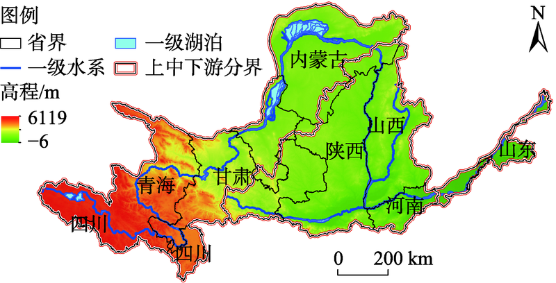
Fig. 1
Topographic map of the Yellow River Basin"
Tab. 1
Comprehensive evaluation index system of land ecological quality in the Yellow River Basin"
| 目标层 | 准则层(权重) | 指标层(权重) | 指标计算 | 性质 | 参考文献 |
|---|---|---|---|---|---|
| 黄河流域土地生态质量综合评价 | 景观特征 (0.140) | 景观形状指数(0.224) | 式中:LSI为景观形状指数;L为斑块周长(m);A为斑块面积(m2)。 | 负 | [ |
| 最大斑块指数(0.173) | 式中:LPI为最大斑块指数; | 正 | [ | ||
| 香农多样性指数(0.267) | 式中:SHDI为香农多样性指数; | 正 | [ | ||
| 景观蔓延度(0.336) | 式中:CONTAG为景观蔓延度;pi为i类型景观占总景观比例; | 正 | [ | ||
| 生境质量抗干扰能力 (0.408) | 归一化植被指数(0.046) | 式中:NDVI为归一化植被指数;NIR为近红外波段;R为红波段。 | 正 | [ | |
| 高程(0.084) | 由数字高程模型(DEM)得到 | 负 | [ | ||
| 坡度(0.091) | 由DEM得到 | 负 | [ | ||
| 离生态保护区距离(0.291) | 保护区数据缓冲区分析得到 | 正 | [ | ||
| 土地利用结构多样性(0.233) | 式中: | 正 | [ | ||
| 离水域距离(0.145) | 由水系数据缓冲区分析得到 | 正 | [ | ||
| 离道路距离(0.110) | 由道路数据缓冲区分析得到 | 负 | [ | ||
| 土地利用社会经济效益 (0.292) | 人口密度(0.010) | 空间化人口密度数据 | 负 | [ | |
| 人均粮食产量(0.186) | 各市粮食总产量/常住人口 | 正 | [ | ||
| 人均收入水平(0.285) | 各市生产总值/常住人口 | 正 | [ | ||
| 经济密度(0.519) | 各市生产总值/土地面积 | 正 | [ | ||
| 土地生态系统服务价值 (0.160) | 生态系统供给服务价值(0.285) | 依据中国生态系统服务价值当量因子表修正后计算得到 | 正 | [ | |
| 生态系统调节服务价值(0.187) | 依据中国生态系统服务价值当量因子表修正后计算得到 | 正 | [ | ||
| 生态系统支持服务价值(0.367) | 依据中国生态系统服务价值当量因子表修正后计算得到 | 正 | [ | ||
| 生态系统文化服务价值(0.161) | 依据中国生态系统服务价值当量因子表修正后计算得到 | 正 | [ |
Tab. 2
Classification standard of some indices of anti-interference ability of habitat"
| 指标 | 分级标准 | 评价值 | 指标 | 分级标准 | 评价值 |
|---|---|---|---|---|---|
| 高程/m | [0,1000] (1000,2000] (2000,3000] >3000 | 1 3 5 7 | 离一级水系距离/m | [0,1000] (1000,2000] (2000,3000] (3000,5000] >5000 | 9 7 5 3 1 |
| 坡度/(°) | [0,5] (5,15] (15,25] >25 | 1 3 5 7 | 离二级水系距离/m | [0,500] (500,1000] (1000,1500] (1500,2500] >2500 | 9 7 5 3 1 |
| 离生态保护区距离/m | 保护区内 保护区外 | 7 1 | 离三级水系距离/m | [0,500] (500,1000] (1000,1500] >2500 | 7 5 3 1 |
| 离道路距离/m | [0,1000] (1000,2000] (2000,3000] >3000 | 7 5 3 1 |
Tab. 3
Ecological service value coefficients of all kinds of land in the Yellow River Basin /元·hm-2"
| 一级类型 | 二级类型 | 森林 | 草地 | 农田 | 湿地 | 水域 | 荒漠 | 建设用地 |
|---|---|---|---|---|---|---|---|---|
| 供给服务 | 食物生产 | 1056.70 | 1376.91 | 3202.11 | 1152.76 | 1697.12 | 64.04 | 0.00 |
| 原材料生产 | 9542.29 | 1152.76 | 1248.82 | 768.51 | 1120.74 | 128.08 | 1120.74 | |
| 调节服务 | 气体调节 | 13833.12 | 4803.17 | 2305.52 | 7717.09 | 1633.08 | 192.13 | 0.00 |
| 气候调节 | 13032.59 | 4995.29 | 3106.05 | 43388.59 | 6596.35 | 416.27 | 0.00 | |
| 水源涵养 | 13096.63 | 4867.21 | 2465.62 | 43036.36 | 60103.60 | 224.15 | -49408.56 | |
| 净化环境 | 5507.63 | 4226.79 | 4450.93 | 46110.38 | 47551.33 | 832.55 | -10342.82 | |
| 支持服务 | 保持土壤 | 12872.48 | 7172.73 | 4707.10 | 6372.20 | 1312.87 | 544.36 | 0.00 |
| 维持生物多样性 | 14441.52 | 5987.95 | 3266.15 | 11815.79 | 10983.24 | 1280.84 | 0.00 | |
| 文化服务 | 提供美学景观 | 6660.39 | 2785.84 | 544.36 | 15017.90 | 14217.37 | 768.51 | 0.00 |
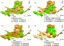
Fig. 2
Comprehensive evaluations of criteria layer indices of land ecological quality in the Yellow River Basin"

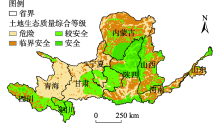
Fig. 3
Comprehensive grade of land ecological quality in the Yellow River Basin"

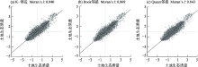
Fig. 4
Moran’s I scatter plot of land ecological quality"

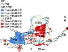
Fig. 5
Distribution of cold and hot spots of land ecological quality in the Yellow River Basin"

Tab. 4
Obstacle level of barrier factors for land ecological quality in the Yellow River Basin"
| 准则层及指标 | 指标障碍度/% | |||
|---|---|---|---|---|
| 危险区 | 临界安全区 | 较安全区 | 安全区 | |
| 景观特征 | 11.482 | 11.873 | 13.127 | 15.716 |
| 生境质量抗干扰能力 | 47.342 | 46.346 | 39.508 | 34.547 |
| 土地利用社会经济效益 | 39.925 | 40.371 | 45.863 | 47.990 |
| 土地生态系统服务价值 | 1.250 | 1.410 | 1.502 | 1.747 |
| 景观形状指数 | 2.807 | 2.867 | 3.007 | 3.839 |
| 最大斑块指数 | 1.351 | 1.295 | 1.261 | 1.832 |
| 香农多样性指数 | 2.740 | 3.092 | 3.808 | 3.839 |
| 景观蔓延度 | 4.584 | 4.619 | 5.051 | 6.206 |
| 归一化植被指数 | 0.617 | 0.891 | 0.820 | 0.956 |
| 高程 | 3.194 | 1.829 | 3.396 | 2.669 |
| 坡度 | 3.014 | 2.294 | 2.637 | 2.922 |
| 离生态保护区距离 | 16.621 | 17.121 | 7.314 | 1.226 |
| 土地利用结构多样性 | 12.554 | 13.325 | 14.390 | 15.344 |
| 离水域距离 | 7.563 | 8.004 | 8.759 | 10.073 |
| 离道路距离 | 3.780 | 2.883 | 2.191 | 1.357 |
| 人口密度 | 0.003 | 0.003 | 0.002 | 0.002 |
| 人均粮食产量 | 6.479 | 5.988 | 7.292 | 8.085 |
| 人均收入水平 | 8.166 | 7.247 | 8.760 | 8.284 |
| 经济密度 | 25.277 | 27.133 | 29.810 | 31.618 |
| [1] | 傅伯杰. 土地资源系统认知与国土生态安全格局[J]. 中国土地, 2019(12):9-11. |
| [Fu Bojie. The cognition of land resource system and the pattern of land ecological security[J]. China Land, 2019(12):9-11. ] | |
| [2] | 于婧, 陈艳红, 彭婕, 等. 基于GIS和Fragstats的土地生态质量综合评价——以湖北省仙桃市为例[J]. 生态学报, 2020, 40(9):2932-2943. |
| [Yu Jing, Chen Yanhong, Peng Jie, et al. Comprehensive evaluation on land ecological quality based on GIS and Fragstats: A case study in Xiantao City, Hubei Province[J]. Acta Ecologica Sinica, 2020, 40(9):2932-2943. ] | |
| [3] | 王根绪, 程国栋, 钱鞠. 生态安全评价研究中的若干问题[J]. 应用生态学报, 2003, 14(9):1551-1556. |
| [Wang Genxu, Cheng Guodong, Qian Ju. Several problems in ecological security assessment research[J]. Chinese Journal of Applied Ecology, 2003, 14(9):1551-1556. ] | |
| [4] |
Thomsen M, Faber J H, Sorensen P B. Soil ecosystem health and services: Evaluation of ecological indicators susceptible to chemical stressors[J]. Ecological Indicators, 2012, 16:67-75.
doi: 10.1016/j.ecolind.2011.05.012 |
| [5] |
Villa F, McLeod H. Environmental vulnerability indicators for environmental planning and decision-making: Guidelines and applications[J]. Environmental Management, 2002, 29(3):335-348.
doi: 10.1007/s00267-001-0030-2 |
| [6] |
De Lange H J, Sala S, Vighi M, et al. Ecological vulnerability in risk assessment: A review and perspectives[J]. Science of the Total Environment, 2010, 408(18):3871-3879.
doi: 10.1016/j.scitotenv.2009.11.009 |
| [7] |
刘焱序, 王仰麟, 彭建, 等. 耦合恢复力的林区土地生态适宜性评价——以吉林省汪清县为例[J]. 地理学报, 2015, 70(3):476-487.
doi: 10.11821/dlxb201503010 |
|
[Liu Yanxu, Wang Yanglin, Peng Jian, et al. Land ecological suitability assessment for forest coupled with the resilience perspective: A case study in Wangqing County, Jilin Province, China[J]. Acta Geographica Sinica, 2015, 70(3):476-487. ]
doi: 10.11821/dlxb201503010 |
|
| [8] | 史娜娜, 全占军, 韩煜, 等. 基于生态敏感性评价的乌海市土地资源承载力分析[J]. 水土保持研究, 2017, 24(1):239-243. |
| [Shi Nana, Quan Zhanjun, Han Yu, et al. Analysis of land resources carrying capacity in Wuhai City based on ecological sensitivity[J]. Research of Soil and Water Conservation, 2017, 24(1):239-243. ] | |
| [9] | 马世五, 谢德体, 张孝成, 等. 三峡库区生态敏感区土地生态安全预警测度与时空演变——以重庆市万州区为例[J]. 生态学报, 2017, 37(24):8227-8240. |
| [Ma Shiwu, Xie Deti, Zhang Xiaocheng, et al. Measures of land ecological security early warning and its spatial-temporal evolution in the ecologically sensitive area of the Three Gorges Reservoir area: A case study of Wanzhou District, Chongqing City[J]. Acta Ecologica Sinica, 2017, 37(24):8227-8240. ] | |
| [10] | 王一山, 张飞, 陈瑞, 等. 乌鲁木齐市土地生态安全综合评价[J]. 干旱区地理, 2021, 44(2):427-440. |
| [Wang Yishan, Zhang Fei, Chen Rui, et al. Comprehensive ecological security assessment: A case study of Urumqi City[J]. Arid Land Geography, 2021, 44(2):427-440. ] | |
| [11] | 郑岚, 张志斌, 笪晓军, 等. 嘉峪关市土地生态安全动态评价及影响因素分析[J]. 干旱区地理, 2021, 44(1):289-298. |
| [Zheng Lan, Zhang Zhibin, Da Xiaojun, et al. Dynamic evaluation and influencing factors of land ecological security in Jiayuguan City[J]. Arid Land Geography, 2021, 44(1):289-298. ] | |
| [12] | 吴景全, 吴铭婉, 臧传富. 西北诸河流域土地利用变化及土地生态安全评估[J]. 干旱区地理, 2021, 44(5):1471-1482. |
| [Wu Jingquan, Wu Mingwan, Zang Chuanfu. Land use change and land ecological security assessment in the river basins of northwestern China[J]. Arid Land Geography, 2021, 44(5):1471-1482. ] | |
| [13] |
Peng J, Liu Y, Li T, et al. Regional ecosystem health response to rural land use change: A case study in Lijiang City, China[J]. Ecological Indicators, 2017, 72:399-410.
doi: 10.1016/j.ecolind.2016.08.024 |
| [14] | 吴滢滢, 吴绍华, 周生路, 等. 昆山市土地生态质量空间分异及其对土地利用程度的响应[J]. 水土保持研究, 2015, 22(4):201-205, 209. |
| [Wu Yingying, Wu Shaohua, Zhou Shenglu, et al. Distribution of land ecological environment and its response to landuse intensity in Kunshan County[J]. Research of Soil and Water Conservation, 2015, 22(4):201-205, 209. ] | |
| [15] | 肖姚, 朱凤武, 周生路, 等. 经济发达地区影响土地生态质量的关键景观格局因子研究——以江苏省昆山市为例[J]. 自然资源学报, 2017, 32(10):1731-1743. |
| [Xiao Yao, Zhu Fengwu, Zhou Shenglu, et al. Key landscape pattern factors affecting land ecological quality in developed areas: A case study of Kunshan City in Jiangsu Province[J]. Journal of Natural Resources, 2017, 32(10):1731-1743. ] | |
| [16] | 徐昌瑜, 陈健, 孟爱农, 等. 基于FRAGSTATS的区域土地生态质量综合评价研究——以江苏省宜兴市为例[J]. 土壤, 2013, 45(2):1355-1360. |
| [Xu Changyu, Chen Jian, Meng Ainong, et al. Study on evaluation of land ecological quality based on FRAGSTATS: A case of Yixing, Jiangsu Province[J]. Soils, 2013, 45(2):1355-1360. ] | |
| [17] |
Messing I, Fagerstrom M H H, Chen L D, et al. Criteria for land suitability evaluation in a small catchment on the Loess Plateau in China[J]. Catena, 2003, 54(1-2):215-234.
doi: 10.1016/S0341-8162(03)00066-3 |
| [18] | 张军以, 苏维词, 张凤太. 基于PSR模型的三峡库区生态经济区土地生态安全评价[J]. 中国环境科学, 2011, 31(6):1039-1044. |
| [Zhang Junyi, Su Weici, Zhang Fengtai. Regional land ecological security evaluation in the case of Chongqing Three Gorges Reservoir ecological economy area based on the PSR model[J]. China Environmental Science, 2011, 31(6):1039-1044. ] | |
| [19] |
Paracchini M L, Pacini C, Jones M L M, et al. An aggregation framework to link indicators associated with multifunctional land use to the stakeholder evaluation of policy options[J]. Ecological Indicators, 2011, 11(1):71-80.
doi: 10.1016/j.ecolind.2009.04.006 |
| [20] |
彭建, 党威雄, 刘焱序, 等. 景观生态风险评价研究进展与展望[J]. 地理学报, 2015, 70(4):664-677.
doi: 10.11821/dlxb201504013 |
|
[Peng Jian, Dang Weixiong, Liu Yanxu, et al. Review on landscape ecological risk assessment[J]. Acta Geographica Sinica, 2015, 70(4):664-677. ]
doi: 10.11821/dlxb201504013 |
|
| [21] |
陆大道, 孙东琪. 黄河流域的综合治理与可持续发展[J]. 地理学报, 2019, 74(12):2431-2436.
doi: 10.11821/dlxb201912001 |
|
[Lu Dadao, Sun Dongqi. Development and management tasks of the Yellow River Basin: A preliminary understanding and suggestion[J]. Acta Geographica Sinica, 2019, 74(12):2431-2436. ]
doi: 10.11821/dlxb201912001 |
|
| [22] | 岳德鹏, 王计平, 刘永兵, 等. GIS与RS技术支持下的北京西北地区景观格局优化[J]. 地理学报, 2007, 62(11):1223-1231. |
| [Yue Depeng, Wang Jiping, Liu Yongbing, et al. Landscape pattern optimization based on RS and GIS in northwest of Beijing[J]. Acta Geographica Sinica, 2007, 62(11):1223-1231. ] | |
| [23] | 傅伯杰, 刘焱序. 系统认知土地资源的理论与方法[J]. 科学通报, 2019, 64(21):2172-2179. |
| [Fu Bojie, Liu Yanxu. The theories and methods for systematically understanding land resource[J]. Chinese Science Bulletin, 2019, 64(21):2172-2179. ] | |
| [24] |
马琳, 刘浩, 彭建, 等. 生态系统服务供给和需求研究进展[J]. 地理学报, 2017, 72(7):1277-1289.
doi: 10.11821/dlxb201707012 |
|
[Ma Lin, Liu Hao, Peng Jian, et al. A review of ecosystem services supply and demand[J]. Acta Geographica Sinica, 2017, 72(7):1277-1289. ]
doi: 10.11821/dlxb201707012 |
|
| [25] | 陈利顶, 傅伯杰. 黄河三角洲地区人类活动对景观结构的影响分析──以山东省东营市为例[J]. 生态学报, 1996, 16(4):337-344. |
| [Chen Liding, Fu Bojie. Analysis of impact of human activity on landscape structure in Yellow River Delta: A case study of Dongying region[J]. Acta Ecologica Sinica, 1996, 16(4):337-344. ] | |
| [26] | 甘琳, 陈颖彪, 吴志峰, 等. 近20年粤港澳大湾区生态敏感性变化[J]. 生态学杂志, 2018, 37(8):2453-2462. |
| [Gan Lin, Chen Yingbiao, Wu Zhifeng, et al. The variation of ecological sensitivity in Guangdong-Hong Kong-Macao Greater Bay Area in recent 20 years[J]. Chinese Journal of Ecology, 2018, 37(8):2453-2462. ] | |
| [27] | 谢高地, 张彩霞, 张昌顺, 等. 中国生态系统服务的价值[J]. 资源科学, 2015, 37(9):1740-1746. |
| [Xie Gaodi, Zhang Caixia, Zhang Changshun, et al. The value of ecosystem services in China[J]. Resources Science, 2015, 37(9):1740-1746. ] | |
| [28] | 巩杰, 赵彩霞, 谢余初, 等. 基于景观格局的甘肃白龙江流域生态风险评价与管理[J]. 应用生态学报, 2014, 25(7):2041-2048. |
| [Gong Jie, Zhao Caixia, Xie Yuchu, et al. Ecological risk assessment and its management of Bailongjiang watershed, southern Gansu based on landscape pattern[J]. Chinese Journal of Applied Ecology, 2014, 25(7):2041-2048. ] | |
| [29] | 周小平, 冯宇晴, 罗维, 等. 两种生态系统服务价值评估方法比较研究——以四川省金堂县三星镇土地整治工程为例[J]. 生态学报, 2020, 40(5):1799-1809. |
| [Zhou Xiaoping, Feng Yuqing, Luo Wei, et al. Comparing two ecosystem service evaluation methods of the ecological benefits from a land consolidation project at a township level: A case study in Sanxing Town, Jintang County of Sichuan Province[J]. Acta Ecologica Sinica, 2020, 40(5):1799-1809. ] | |
| [30] | 李敏. 基于土地利用变化的生态系统服务价值研究[D]. 合肥: 合肥工业大学, 2015. |
| [Li Min. Study on ecosystem services value based on land use change[D]. Hefei: Hefei University of Technology, 2015. ] | |
| [31] |
徐少癸, 左逸帆, 章牧. 基于模糊物元模型的中国旅游生态安全评价及障碍因子诊断研究[J]. 地理科学, 2021, 41(1):33-43.
doi: 10.13249/j.cnki.sgs.2021.01.004 |
|
[Xu Shaogui, Zuo Yifan, Zhang Mu. Evaluation of tourism ecological security and diagnosis of obstacle factors in China based on fuzzy object element model[J]. Scientia Geographica Sinica, 2021, 41(1):33-43. ]
doi: 10.13249/j.cnki.sgs.2021.01.004 |
|
| [32] | 纪学朋, 黄贤金, 陈逸, 等. 基于陆海统筹视角的国土空间开发建设适宜性评价——以辽宁省为例[J]. 自然资源学报, 2019, 34(3):451-463. |
| [Ji Xuepeng, Huang Xianjin, Chen Yi, et al. Comprehensive suitability evaluation of spatial development and construction land in the perspective of land-ocean co-ordination: A case study of Liaoning Province, China[J]. Journal of Natural Resources, 2019, 34(3):451-463. ] | |
| [33] | 杨开忠, 苏悦, 顾芸. 新世纪以来黄河流域经济兴衰的原因初探——基于偏离-份额分析法[J]. 经济地理, 2021, 41(1):10-20. |
| [Yang Kaizhong, Su Yue, Gu Yun. Causes of economic rise and fall in the Yellow River Basin after 2000: Based on the shift-share analysis method[J]. Economic Geography, 2021, 41(1):10-20. ] | |
| [34] | 刘琳轲, 梁流涛, 高攀, 等. 黄河流域生态保护与高质量发展的耦合关系及交互响应[J]. 自然资源学报, 2021, 36(1):176-195. |
| [Liu Linke, Liang Liutao, Gao Pan, et al. Coupling relationship and interactive response between ecological protection and high quality development in the Yellow River Basin[J]. Journal of Natural Resources, 2021, 36(1):176-195. ] | |
| [35] | 姚文艺, 刘国彬. 新时期黄河流域水土保持战略目标的转变与发展对策[J]. 水土保持通报, 2020, 40(5):333-340. |
| [Yao Wenyi, Liu Guobin. Strategic goal change and development countermeasures of soil and water conservation in Yellow River Basin in new period[J]. Bulletin of Soil and Water Conservation, 2020, 40(5):333-340. ] | |
| [36] | 张振东, 常军. 2001—2018年黄河流域植被NPP的时空分异及生态经济协调性分析[J]. 华中农业大学学报, 2021, 40(2):166-177. |
| [Zhang Zhendong, Chang Jun. Spatial-temporal differentiation and eco-economic coordination of vegetation NPP in the Yellow River Basin from 2001 to 2018[J]. Journal of Huazhong Agricultural University, 2021, 40(2):166-177. ] | |
| [37] | 郭利刚, 冯珍珍, 刘庚, 等. 基于物元模型的汾河流域土地生态安全评价[J]. 生态学杂志, 2020, 39(6):2061-2069. |
| [Guo Ligang, Feng Zhenzhen, Liu Gen, et al. Evaluation of land eco-security in Fenhe River Basin based on matter-element model[J]. Chinese Journal of Ecology, 2020, 39(6):2061-2069. ] | |
| [38] | 任保平, 杜宇翔. 黄河流域经济增长-产业发展-生态环境的耦合协同关系[J]. 中国人口·资源与环境, 2021, 31(2):119-129. |
| [Ren Baoping, Du Yuxiang. Coupling coordination of economic growth, industrial development and ecology in the Yellow River Basin[J]. China Population, Resources and Environment, 2021, 31(2):119-129. ] | |
| [39] | 王思远, 王光谦, 陈志祥. 黄河流域生态环境综合评价及其演变[J]. 山地学报, 2004, 22(2):133-139. |
| [Wang Siyuan, Wang Guangqian, Chen Zhixiang. Eco-environmental evaluation and changes in Yellow River Basin[J]. Mountain Research, 2004, 22(2):133-139. ] | |
| [40] | 李达, 林龙圳, 林震, 等. 黄河流域生态保护和高质量发展的EKC检验[J]. 生态学报, 2021, 41(10):3965-3974. |
| [Li Da, Lin Longzhen, Lin Zhen, et al. EKC test of ecological protection and high-quality development in the Yellow River Basin[J]. Acta Ecologica Sinica, 2021, 41(10):3965-3974. ] | |
| [41] | 熊建华. 土地生态安全评价研究回顾、难点与思考[J]. 地理与地理信息科学, 2018, 34(6):71-76. |
| [Xiong Jianhua. Review, difficulties and thinking of land ecological security evaluation[J]. Geography and Geo-Information Science, 2018, 34(6):71-76. ] |
|
||