Arid Land Geography ›› 2022, Vol. 45 ›› Issue (5): 1547-1558.doi: 10.12118/j.issn.1000-6060.2022.018
• Biology and Pedology • Previous Articles Next Articles
XIE Conghui1,2( ),WU Shixin1(),LIN Juan3,ZHUANG Qingwei4,ZHANG Zihui1,2,HOU Guanyu1,2,LUO Geping1
Received:2022-01-11
Revised:2022-02-11
Online:2022-09-25
Published:2022-10-20
Contact:
Shixin WU
E-mail:xieconghui19@mails.ucas.ac.cn;wushixin@ms.xjb.ac.cn
XIE Conghui,WU Shixin,LIN Juan,ZHUANG Qingwei,ZHANG Zihui,HOU Guanyu,LUO Geping. Analysis of cultivated land salinization in Kashgar Oasis based on PSO-PNN model[J].Arid Land Geography, 2022, 45(5): 1547-1558.

Fig. 1
Distribution of sampling points in the study area"

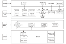
Fig. 2
Technical route"

Tab. 1
Characteristic variable of remote sensing index"
| 类别 | 名称 | 公式 |
|---|---|---|
| 植被指数 | 归一化植被指数(NDVI) | |
| 增强型植被指数(EVI) | | |
| 修改型土壤调节植被指数 (MSAVI) | | |
| 盐分指数 | 盐分指数(SI) | |
| 归一化盐分指数(NDSI) | | |
| 盐分指数2(SI2) | | |
| 盐分指数3(SI3) | | |
| K-T变换因子 | 湿度指数(WI) | |
| 绿度指数(GVI) | | |
| 下垫面反射因子 | 地表反照率(Albedo) | |
| | | |
| 多维特征空间 | MSAVI-WI特征空间(MWI) | |
| NDVI-SI特征空间(SDI) | | |
| MSAVI-WI-SI特征空间(MWSI) | | |
| 波段反射率因子 | 波段2~7(B2、B3、B4、B5、B6、B7) | |
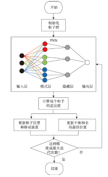
Fig. 3
Flow chart of particle swarm optimization (PSO)"


Fig. 4
Correlation between candidate indices and total salt"

Tab. 2
Sample grading"
| 盐渍化程度等级 | 总盐/mg·g-1 |
|---|---|
| 第一级 | 0.00~3.05 |
| 第二级 | 3.05~7.42 |
| 第三级 | 7.42~11.30 |
| 第四级 | 11.30~12.60 |
| 第五级 | 12.60~13.90 |
| 第六级 | 13.90~17.60 |
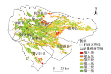
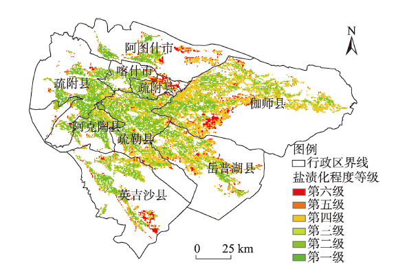
Fig. 5
Classification of cultivated land salinization in Kashgar Oasis"
Tab. 3
Proportion of the graded area of cultivated land salinization in the cities and counties of Kashgar Oasis"
| 市县 | 盐渍化等级占比/% | 总面积/km2 | |||||||
|---|---|---|---|---|---|---|---|---|---|
| 第一级 | 第二级 | 第三级 | 第一至第三级 | 第四级 | 第五级 | 第六级 | 第四至第六级 | ||
| 阿克陶县 | 25.01 | 0.14 | 46.38 | 71.53 | 21.41 | 1.67 | 5.39 | 28.47 | 463.77 |
| 疏附县 | 25.05 | 0.05 | 42.68 | 67.78 | 20.20 | 1.27 | 10.76 | 32.22 | 1030.86 |
| 喀什市 | 22.25 | 0.00 | 43.28 | 65.53 | 18.07 | 0.75 | 15.65 | 34.47 | 215.64 |
| 疏勒县 | 15.40 | 0.07 | 43.74 | 59.21 | 33.44 | 0.67 | 6.69 | 40.79 | 1292.31 |
| 英吉沙县 | 15.58 | 0.05 | 37.43 | 53.05 | 27.81 | 0.86 | 18.28 | 46.95 | 752.85 |
| 阿图什市 | 20.41 | 0.00 | 30.65 | 51.06 | 26.89 | 0.66 | 21.39 | 48.94 | 423.36 |
| 岳普湖县 | 10.92 | 0.11 | 33.13 | 44.16 | 43.42 | 0.42 | 12.00 | 55.84 | 985.23 |
| 伽师县 | 6.95 | 0.07 | 32.46 | 39.48 | 48.53 | 0.40 | 11.60 | 60.52 | 2162.34 |
| 总计 | 14.78 | 0.07 | 37.58 | 52.43 | 35.20 | 0.72 | 11.65 | 47.57 | 7326.36 |
Tab. 4
Relationship between the age of cultivated land reclamation and salinization in Kashgar Oasis"
| 耕地开垦年限/a | 盐渍化等级占比/% | 总面积/km2 | |||||
|---|---|---|---|---|---|---|---|
| 第一级 | 第二级 | 第三级 | 第四级 | 第五级 | 第六级 | ||
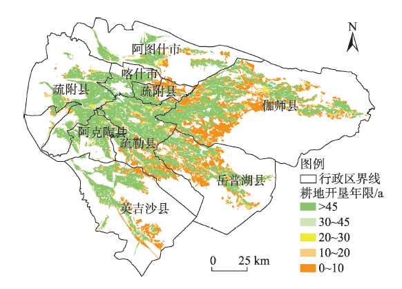
| 0~10 | 1.27 | 0.08 | 13.24 | 57.28 | 1.09 | 27.03 | 2015.73 |
| 11~20 | 3.98 | 0.04 | 25.50 | 53.93 | 1.09 | 15.45 | 486.27 |
| 21~30 | 9.58 | 0.11 | 37.60 | 42.82 | 1.29 | 8.61 | 167.31 |
| 31~45 | 12.17 | 0.05 | 43.83 | 34.29 | 0.83 | 8.83 | 390.33 |
| >45 | 22.83 | 0.07 | 49.89 | 22.42 | 0.47 | 4.32 | 4266.72 |
| 总计 | 14.78 | 0.07 | 37.58 | 35.20 | 0.72 | 11.65 | 7326.36 |

Fig. 6
Age of cultivated land in Kashgar Oasis"
Tab. 5
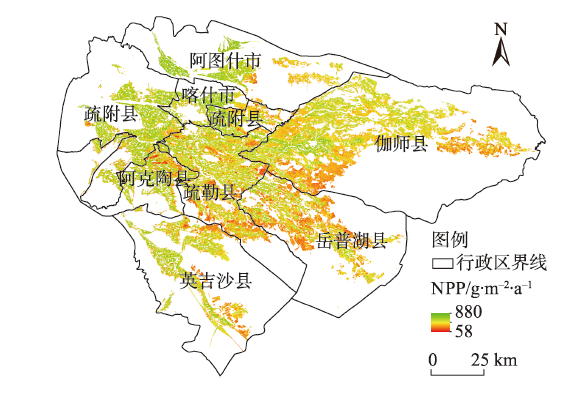
Area of different salinization grades of cultivated land and its corresponding NPP in Kashgar Oasis"
| 盐渍化等级 | 面积/km2 | NPP/g·m-2·a-1 |
|---|---|---|
| 第一级 | 1063.80 | 719.33 |
| 第二级 | 4.86 | 630.39 |
| 第一至第二级 | 1068.66 | 718.93 |
| 第三级 | 2695.77 | 696.29 |
| 第四级 | 2515.14 | 651.98 |
| 第三至第四级 | 5210.91 | 674.90 |
| 第五级 | 50.13 | 636.22 |
| 第六级 | 808.47 | 639.25 |
| 第五至第六级 | 858.60 | 639.08 |
Fig. 7
Vegetation NPP of cultivated land in Kashgar Oasis"
| [1] | Mahmoud A A, Shabbir A S, Yasser R O. Soil salinity mapping model developed using RS and GIS: A case study from Abu Dhabi, United Arab Emirates[J]. European Journal of Scientific Research, 2010, 26(3): 342-351. |
| [2] | 丁建丽, 姚远, 王飞. 基于三维光谱特征空间的干旱区土壤盐渍化遥感定量研究[J]. 土壤学报, 2013, 50(5): 853-861. |
| [Ding Jianli, Yao Yuan, Wang Fei. Quantitative remote sensing of soil salinization in arid regions based on three dimensional spectrum eigen spaces[J]. Acta Pedologica Sinica, 2013, 50(5): 853-861. ] | |
| [3] |
Peng J, Biswas A, Jiang Q S, et al. Estimating soil salinity from remote sensing and terrain data in southern Xinjiang Province, China[J]. Geoderma, 2018, 337: 1309-1319.
doi: 10.1016/j.geoderma.2018.08.006 |
| [4] | 谭军利, 康跃虎, 焦艳平, 等. 不同种植年限覆膜滴灌盐碱地土壤盐分离子分布特征[J]. 农业工程学报, 2008, 24(6): 59-63. |
| [Tan Junli, Kang Yuehu, Jiao Yanping, et al. Characteristics of soil salinity and salt ions distribution in salt-affected field under mulch-drip irrigation in different planting years[J]. Transactions of the CSAE, 2008, 24(6): 59-63. ] | |
| [5] | 刘圣锋, 高柏, 张海阳, 等. 塔里木盆地西部地下水水质评价及氟化物富集特征——以阿克陶县为例[J]. 干旱区地理, 2021, 44(5): 1261-1271. |
| [Liu Shengfeng, Gao Bai, Zhang Haiyang, et al. Evaluation of groundwater quality and fluoride enrichment characteristics in western Tarim Basin: A case study of Akto County[J]. Arid Land Geography, 2021, 44(5): 1261-1271. ] | |
| [6] | 梁萌, 米晓军, 李晨华, 等. 新疆准噶尔盆地未开垦盐碱土盐分与盐生植被多样性分析[J]. 干旱区地理, 2022, 45(1): 185-196. |
| [Liang Meng, Mi Xiaojun, Li Chenhua, et al. Salinity characteristics and halophytic vegetation diversity of uncultivated saline-alkali soil in Junggar Basin, Xinjiang[J]. Arid Land Geography, 2022, 45(1): 185-196. ] | |
| [7] |
苏里坦, 阿不都·沙拉木, 宋郁东. 膜下滴灌水量对土壤水盐运移及再分布的影响[J]. 干旱区研究, 2011, 28(1): 79-84.
doi: 10.3724/SP.J.1148.2011.00079 |
|
[Su Litan, Salamu Abdu, Song Yudong. Effects of drip irrigation volume on soil water-salt transfer and its redistribution[J]. Arid Zone Research, 2011, 28(1): 79-84. ]
doi: 10.3724/SP.J.1148.2011.00079 |
|
| [8] | 刘恒, 钟华平, 顾颖. 西北干旱内陆河区水资源利用与绿洲演变规律研究——以石羊河流域下游民勤盆地为例[J]. 水科学进展, 2001, 12(3): 378-384. |
| [Liu Heng, Zhong Huaping, Gu Ying. Water resources development and oasis evolution in inland river basin of arid zone of northwest China: A case study of Minqin Basin of Shiyang River[J]. Advances in Water Science, 2001, 12(3): 378-384. ] | |
| [9] | 虎胆·吐马尔白, 赵永成, 马合木江·艾合买提, 等. 北疆常年膜下滴灌棉田土壤盐分积累特征研究[J]. 灌溉排水学报, 2016, 35(1): 1-5. |
| [Tumalbai Hudan, Zhao Yongcheng, Aihemat Mahemujiang, et al. Study on characteristics of cotton field soil accumulation under perennial mulched drip irrigation in northern Xinjiang[J]. Journal of Irrigation and Drainage, 2016, 35(1): 1-5. ] | |
| [10] | 吴亚坤, 刘广明, 杨劲松, 等. 基于反距离权重插值的土壤盐分三维分布解析方法[J]. 农业工程学报, 2013, 29(3): 100-106. |
| [Wu Yakun, Liu Guangming, Yang Jinsong, et al. Interpreting method of region soil salinity 3D distribution based on inverse distance weighting[J]. Transactions of the China Society of Agricultural Engineering, 2013, 29(3): 100-106. ] | |
| [11] | 董积忠. 喀什地区耕地土壤盐渍化现状及改良对策[J]. 新疆农业科技, 2013(5): 34-35. |
| [Dong Jizhong. Current situation and improvement countermeasures of soil salinization in cultivated land in Kashgar[J]. Xinjiang Agricultural Science and Technology, 2013(5): 34-35. ] | |
| [12] | 阿不都拉·阿不力孜. 于田绿洲土壤盐分分布特征及其生态效应[D]. 乌鲁木齐: 新疆大学, 2016. |
| [Abuliz Abdullah. Characteristics of soil salinity distribution and its ecological effects in Yutian Oasis[D]. Urumqi: Xinjiang University, 2016. ] | |
| [13] | 曹雷, 丁建丽, 于海洋. 渭-库绿洲多尺度景观格局与盐度关系[J]. 农业工程学报, 2016, 32(3): 101-110. |
| [Cao Lei, Ding Jianli, Yu Haiyang. Relationship between multi-scale landscape pattern and salinity in Weigan and Kuqa rivers delta oasis[J]. Transactions of the China Society of Agricultural Engineering, 2016, 32(3): 101-110. ] | |
| [14] | 牛增懿, 丁建丽, 李艳华, 等. 基于高分一号影像的土壤盐渍化信息提取方法[J]. 干旱区地理, 2016, 39(1): 171-181. |
| [Niu Zengyi, Ding Jianli, Li Yanhua, et al. Soil salinization information extraction method based on GF-1 image[J]. Arid Land Geography, 2016, 39(1): 171-181. ] | |
| [15] | 梁静, 丁建丽, 王敬哲, 等. 基于反射光谱与 Landsat 8 OLI 多光谱数据的艾比湖湿地土壤盐分估算[J]. 土壤学报, 2019, 56(2): 72-82. |
| [Liang Jing, Ding Jianli, Wang Jingzhe, et al. Quantitative estimation and mapping of soil salinity in the Ebinur Lake wetland based on Vis-NIR reflectance and Landsat 8 OLI data[J]. Acta Pedologica Sinica, 2019, 56(2): 72-82. ] | |
| [16] | 郭鹏, 李华, 陈红艳, 等. 基于光谱指数优选的土壤盐分定量光谱估测[J]. 水土保持通报, 2018, 38(3): 193-199. |
| [Guo Peng, Li Hua, Chen Hongyan, et al. Quantitative spectral estimation of soil salinity based on optimum spectral indices[J]. Bulletin of Soil and Water Conservation, 2018, 38(3): 193-199. ] | |
| [17] | 阿尔达克·克里木. 艾比湖流域盐渍化土壤的多光谱和高光谱遥感反演与生态效应研究[D]. 乌鲁木齐: 新疆大学, 2016. |
| [Kerimu Aldak. Multispectral and hyperspectral remote sensing inversion and ecological effects of salinized soils in the Lake Aibi Basin[D]. Urumqi: Xinjiang University, 2016. ] | |
| [18] | 依力亚斯江·努尔麦麦提. 土壤盐渍化微波遥感监测及其风险定量估计研究[D]. 乌鲁木齐: 新疆大学, 2016. |
| [Nuermaiti Yiliyasijiang. Research on microwave remote sensing monitoring of soil salinization and its risk quantitative estimation[D]. Urumqi: Xinjiang University, 2016. ] | |
| [19] | 丁建丽, 张喆, 李鑫, 等. 中亚土库曼斯坦绿洲土壤盐渍化动态演变评估[J]. 干旱区地理, 2013, 36(4): 571-578. |
| [Ding Jianli, Zhang Zhe, Li Xin, et al. Assessment of dynamic evolution on soil salinization of an oasis in Turkmenistan of Central Asia[J]. Arid Land Geography, 2013, 36(4): 571-578. ] | |
| [20] | 丁建丽, 瞿娟, 孙永猛, 等. 基于MSAVI-WI特征空间的新疆渭干河-库车河流域绿洲土壤盐渍化研究[J]. 地理研究, 2013, 32(2): 223-232. |
| [Ding Jianli, Qu Juan, Sun Yongmeng, et al. The retrieval model of soil salinization information in arid region based on MSAVI-WI feature space: A case study of the delta oasis in Weigan-Kuqa watershed[J]. Geographical Research, 2013, 32(2): 223-232. ] | |
| [21] | Allbed A, Kumar L, Aldakheel Y Y. Assessing soil salinity using soil salinity and vegetation indices derived from IKONOS high-spatial resolution imageries: Applications in a date palm dominated region[J]. Geoderma, 2014, 230-231: 1-8. |
| [22] |
Weng Y L, Gong P, Zhu Z L. A spectral index for estimating soil salinity in the Yellow River delta region of China using EO-1 Hyperion data[J]. Pedosphere, 2010, 20(3): 378-388.
doi: 10.1016/S1002-0160(10)60027-6 |
| [23] |
Dehni A, Lounis M. Remote sensing techniques for salt affected soil mapping: Application to the Oran region of Algeria[J]. Procedia Engineering, 2012, 33: 188-198.
doi: 10.1016/j.proeng.2012.01.1193 |
| [24] |
Ketata M, Gueddari M, Bouhlila R. Hydrodynamic and salinity evolution of groundwaters during artificial recharge within semi-arid coastal aquifers: A case study of El Khairat aquifer system in Enfidha (Tunisian Sahel)[J]. Journal of African Earth Sciences, 2014, 97: 224-229.
doi: 10.1016/j.jafrearsci.2014.05.002 |
| [25] |
Wei G F, Li Y, Zhang Z T, et al. Estimation of soil salt content by combining UAV-borne multispectral sensor and machine learning algorithms[J]. PeerJ, 2020, 8(2): e9087, doi: 10.7717/peerj.9087.
doi: 10.7717/peerj.9087 |
| [26] |
Fu C B, Gan S, Yuan X P, et al. Determination of soil salt content using a probability neural network model based on particle swarm optimization in areas affected and non-affected by human activities[J]. Remote Sensing, 2018, 10(9): 1387, doi: 10.3390/rs10091387.
doi: 10.3390/rs10091387 |
| [27] | 葛翔宇, 丁建丽, 王敬哲, 等. 基于竞争适应重加权采样算法耦合机器学习的土壤含水量估算[J]. 光学学报, 2018, 38(10): 393-400. |
| [Ge Xiangyu, Ding Jianli, Wang Jingzhe, et al. Estimation of soil moisture content based on competitive adaptive reweighted sampling algorithm coupled with machine learning[J]. Acta Optica Sinica, 2018, 38(10): 393-400. ] | |
| [28] | 蔡亮红. 基于变量优选和ELM算法的土壤含水量估测研究[D]. 乌鲁木齐: 新疆大学, 2018. |
| [Cai Lianghong. Prediction for soil water content based on variable preferred and extreme learning machine algorithm[D]. Urumqi: Xinjiang University, 2018. ] | |
| [29] |
Specht D F. Probabilistic neural networks[J]. Neural Networks, 1990, 3(1): 109-118.
doi: 10.1016/0893-6080(90)90049-Q |
| [30] |
De Oliveira M A, Inman D. Performance analysis of simplified Fuzzy ARTMAP and Probabilistic Neural Networks for identifying structural damage growth[J]. Applied Soft Computing, 2017, 52: 53-63.
doi: 10.1016/j.asoc.2016.12.020 |
| [31] |
Sankari Z, Adeli H. Probabilistic neural networks for diagnosis of Alzheimer’s disease using conventional and wavelet coherence[J]. Journal of Neuroscience Methods, 2011, 197(1): 165-170.
doi: 10.1016/j.jneumeth.2011.01.027 pmid: 21310177 |
| [32] |
Tian A H, Fu C B, Yau H T, et al. A new methodology of soil salinization degree classification by probability neural network model based on centroid of fractional Lorenz chaos self-synchronization error dynamics[J]. IEEE Transactions on Geoscience and Remote Sensing, 2020, 58(2): 799-810.
doi: 10.1109/TGRS.2019.2940592 |
| [33] | 朱宏, 周宏飞, 陈小兵, 等. 新疆喀什地区的地下水资源特征分析[J]. 干旱区研究, 2005, 22(2): 153-155. |
| [Zhu Hong, Zhou Hongfei, Chen Xiaobing, et al. Analysis on the characteristics of groundwater resources in Kashgar Prefecture, Xinjiang[J]. Arid Zone Research, 2005, 22(2): 153-155. ] | |
| [34] | 毛炜峄, 孙本国, 王铁, 等. 近50年来喀什噶尔河流域气温、降水及径流的变化趋势[J]. 干旱区研究, 2006, 23(4): 531-538. |
| [Mao Weiyi, Sun Benguo, Wang Tie, et al. Change trends of temperature, precipitation and runoff volume in the Kaxgar River Basin since recent 50 years[J]. Arid Zone Research, 2006, 23(4): 531-538. ] | |
| [35] |
Griggs D J, Noguer M. Climate change 2001: The scientific basis. Contribution of working group I to the third assessment report of the intergovernmental panel on climate change[J]. Weather, 2002, 57(8): 267-269.
doi: 10.1256/004316502320517344 |
| [36] |
Jiang H L, Xu X, Guan M X, et al. Determining the contributions of climate change and human activities to vegetation dynamics in agro-pastural transitional zone of northern China from 2000 to 2015[J]. Science of the Total Environment, 2020, 718: 134871, doi: 10.1016/j.scitotenv.2019.134871.
doi: 10.1016/j.scitotenv.2019.134871 |
| [37] |
Xie C H, Wu S X, Zhuang Q W, et al. Where anthropogenic activity occurs, anthropogenic activity dominates vegetation net primary productivity change[J]. Remote Sensing, 2022, 14: 1092, doi: 10.3390/rs14051092.
doi: 10.3390/rs14051092 |
| [38] | Ding J L, Yu D L. Monitoring and evaluating spatial variability of soil salinity in dry and wet seasons in the Werigan-Kuqa Oasis, China, using remote sensing and electromagnetic induction instruments[J]. Geoderma, 2014, 235-236: 316-322. |
| [39] | Gu F X, Yu C, Zhang Y D, et al. Spatial and temporal dynamics of soil moisture and salinity in typical plant communities of Sangonghe Basin[J]. Proceedings of SPIE-The International Society for Optical Engineering, 2003, 4890(1): 471-479. |
| [40] |
Wang H S, Jia G S. Satellite-based monitoring of decadal soil salinization and climate effects in a semi-arid region of China[J]. Advances in Atmospheric Sciences, 2012, 29(5): 1089-1099.
doi: 10.1007/s00376-012-1150-8 |
| [41] |
Ali Baig M H, Zhang L F, Shuai T, et al. Derivation of a tasselled cap transformation based on Landsat 8 at-satellite reflectance[J]. Remote Sensing Letters, 2014, 5(4-6): 423-431.
doi: 10.1080/2150704X.2014.915434 |
| [42] |
Guo B, Yang F, Fan Y W, et al. Dynamic monitoring of soil salinization in Yellow River Delta utilizing MSAVI-SI feature space models with Landsat images[J]. Environmental Earth Sciences, 2019, 78(10): 308, doi: 10.1007/s12665-019-8319-8.
doi: 10.1007/s12665-019-8319-8 |
| [43] |
Ma Z Q, Shi Z, Zhou Y, et al. A spatial data mining algorithm for downscaling TMPA 3B43 V7 data over the Qinghai-Tibet Plateau with the effects of systematic anomalies removed[J]. Remote Sensing of Environment, 2017, 200: 378-395.
doi: 10.1016/j.rse.2017.08.023 |
| [44] |
Said N, Henning B, Joachim H, et al. Modeling and mapping of soil salinity with reflectance spectroscopy and landsat data using two quantitative methods (PLSR and MARS)[J]. Remote Sensing, 2014, 6(11): 10813-10834.
doi: 10.3390/rs61110813 |
| [45] | Wang F, Ding J L, Wu M C. Remote sensing monitoring models of soil salinization based on NDVI-SI feature space[J]. Transactions of the Chinese Society of Agricultural Engineering, 2010, 26(8): 168-173. |
| [46] |
罗亮, 闫慧敏, 牛忠恩. 农田生产力监测中3种多源遥感数据融合方法的对比分析[J]. 地球信息科学学报, 2018, 20(2): 268-279.
doi: 10.12082/dqxxkx.2018.170068 |
|
[Luo Liang, Yan Huimin, Niu Zhong’en. Comparative analysis on three multi-source remote sensing data fusion models in monitoring farmland productivity[J]. Journal of Geo-information Science, 2018, 20(2): 268-279. ]
doi: 10.12082/dqxxkx.2018.170068 |
|
| [47] |
Lobell D B, Hicke J A, Asner G P, et al. Satellite estimates of productivity and light use efficiency in united states agriculture, 1982-98[J]. Global Change Biology, 2002, 8(8): 722-735.
doi: 10.1046/j.1365-2486.2002.00503.x |
| [48] |
Xue B, Zhang M J, Browne W N. Particle swarm optimization for feature selection in classification: A multi-objective approach[J]. IEEE Transactions on Cybernetics, 2013, 43(6): 1656-1671.
doi: 10.1109/TSMCB.2012.2227469 pmid: 24273143 |
| [49] |
Kuila P, Jana P K. Energy efficient clustering and routing algorithms for wireless sensor networks: Particle swarm optimization approach[J]. Engineering Applications of Artificial Intelligence, 2014, 33: 127-140.
doi: 10.1016/j.engappai.2014.04.009 |
| [50] |
Ishaque K, Salam Z, Amjad M, et al. An improved particle swarm optimization (PSO)-based MPPT for PV with reduced steady-state oscillation[J]. IEEE Transactions on Power Electronics, 2012, 27(8): 3627-3638.
doi: 10.1109/TPEL.2012.2185713 |
| [51] |
Chatterjee A, Siarry P. Nonlinear inertia weight variation for dynamic adaptation in particle swarm optimization[J]. Computers & Operations Research, 2006, 33(3): 859-871.
doi: 10.1016/j.cor.2004.08.012 |
| [52] |
朱文会, 毛飞, 徐影, 等. 三江源区植被指数对气候变化的响应及预测分析[J]. 高原气象, 2019, 38(4): 693-704.
doi: 10.7522/j.issn.1000-0534.2018.00105 |
|
[Zhu Wenhui, Mao Fei, Xu Ying, et al. Analysis on response of vegetation index to climate change and its prediction in the three-rivers-source region[J]. Plateau Meteorology, 2019, 38(4): 693-704. ]
doi: 10.7522/j.issn.1000-0534.2018.00105 |
|
| [53] | 杨劲松, 姚荣江, 王相平, 等. 防止土壤盐渍化, 提高土壤生产力[J]. 科学, 2021, 73(6): 30-34, 2, 4. |
| [Yang Jinsong, Yao Rongjiang, Wang Xiangping, et al. Prevent soil salinization and improve soil productivity[J]. Science, 2021, 73(6): 30-34, 2, 4. ] |
| [1] | PAN Xue, GUAN Yuqi, PAN Zhandong, LIU Jie, CAI Liqun, DONG Bo, DU Jian. Spatiotemporal variation and evaluation of cultivated land quality grade in arid areas: A case of Xining City [J]. Arid Land Geography, 2023, 46(5): 793-803. |
| [2] | TANG Yuanhang,LI Mengqi,DENG Ling,WANG Xiaoli. Glacier change and its response to climate change in Pumqu Basin during 1990—2020 [J]. Arid Land Geography, 2022, 45(1): 27-36. |
| [3] | LU Zhuoyu,CUI Jianxin,ZHANG Xiaohong,LI Peng. Historical changes reconstruction of Tonghalake Lake in the Mu Us Sandy Land from Qing Dynasty to Republic of China [J]. Arid Land Geography, 2021, 44(4): 1083-1092. |
| [4] | WANG Bing,AN Hui-jun,LV Chang-wei. Spatial variations of dissolved oxygen in Hulun Lake using geostatistics and GIS technology [J]. , 2013, 36(6): 1103-1110. |
|
||