- Aug. 8, 2025
Arid Land Geography ›› 2023, Vol. 46 ›› Issue (5): 689-699.doi: 10.12118/j.issn.1000-6060.2022.425
• Climatology and Hydrology • Previous Articles Next Articles
LI Lele1( ),CHAO Jinlong1(),ZHAO Deyi2,LI Haojie1,WU Lindong3,LI Jiajun1
Received:2022-08-29
Revised:2022-10-07
Online:2023-05-25
Published:2023-06-05
LI Lele, CHAO Jinlong, ZHAO Deyi, LI Haojie, WU Lindong, LI Jiajun. Spatiotemporal distribution characteristics of rainstorm and risk assessment of rainstorm disasters in Shanxi Province from 1957 to 2019[J].Arid Land Geography, 2023, 46(5): 689-699.
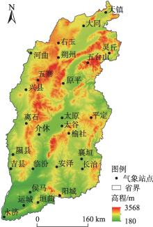
Fig. 1
Distribution of the 27 meteorological stations in the study area"

Tab. 1
Weight judgment matrix of criterion layer indices and consistency test"
| 准则层 | 致灾 因子 | 孕灾 环境 | 承灾体 | 防灾减 灾能力 | 权重值 /% |
|---|---|---|---|---|---|
| 致灾因子 | 1 | 4 | 5 | 7 | 58.098 |
| 孕灾环境 | 1/4 | 1 | 3 | 5 | 24.290 |
| 承灾体 | 1/5 | 1/3 | 1 | 3 | 12.011 |
| 防灾减灾能力 | 1/7 | 1/5 | 1/3 | 1 | 5.601 |
| λmax=4.180,CI=0.060,RI=0.890,CR=0.067<0.1 | |||||
Tab. 2
Weight judgment matrix of disaster factors indices layer and consistency test"
| 致灾因子 | 年均 降雨量 | 年均暴 雨日数 | 日最大 降雨量 | 权重值/% |
|---|---|---|---|---|
| 年均降雨量 | 1 | 1/7 | 1/3 | 8.331 |
| 年均暴雨日数 | 7 | 1 | 5 | 72.351 |
| 日最大降雨量 | 3 | 1/5 | 1 | 19.319 |
| λmax=3.066,CI=0.033,RI=0.520,CR=0.063<0.1 | ||||
Tab. 3
Weight judgment matrix of gestational disaster environment indices layer and consistency test"
| 孕灾环境 | 海拔高程 | 地形坡度 | 河网密度 | 权重值/% |
|---|---|---|---|---|
| 海拔高程 | 1 | 1/2 | 1/3 | 16.378 |
| 地形坡度 | 2 | 1 | 1/2 | 29.726 |
| 河网密度 | 3 | 2 | 1 | 53.896 |
| λmax=3.009,CI=0.005,RI=0.520,CR=0.009<0.1 | ||||
Tab. 4
Weight judgment matrix of disaster bearing body indices layer and consistency test"
| 承灾体 | 人口密度 | 地均GDP | 耕地 面积比 | 权重值/% |
|---|---|---|---|---|
| 人口密度 | 1 | 2 | 3 | 53.896 |
| 地均GDP | 1/2 | 1 | 2 | 29.726 |
| 耕地面积比 | 1/3 | 1/2 | 1 | 16.378 |
| λmax=3.009,CI=0.005,RI=0.520,CR=0.009<0.1 | ||||
Tab. 5
Weight judgment matrix of disaster prevention and mitigation capacity indices layer and consistency test"
| 防灾减灾能力 | 人均GDP | 权重值/% |
|---|---|---|
| 人均GDP | 1 | 100 |
| λmax=0,CI=RI=0 | ||
Tab. 6
Risk assessment index system of rainstorm disaster"
| 目标层 | 准则层 | 准则层权重值/% | 指标层 | 指标层权重值/% |
|---|---|---|---|---|
| 暴雨灾害风险评估 | 致灾因子 | 58.098 | 年均降雨量/mm | 8.331 |
| 年均暴雨日数/d | 72.351 | |||
| 日最大降雨量/mm | 19.319 | |||
| 孕灾环境 | 24.290 | 海拔高程/m | 16.378 | |
| 地形坡度/(°) | 29.726 | |||
| 河网密度/% | 53.896 | |||
| 承灾体 | 12.011 | 人口密度/人·km-2 | 53.896 | |
| 地均GDP/104元 | 29.726 | |||
| 耕地面积比/% | 16.378 | |||
| 防灾减灾能力 | 5.601 | 人均GDP/元 | 100.000 |
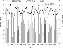
Fig. 2
Interannual variation of cumulative rainstorm days and annual average rainstorm amount in Shanxi Province"

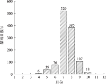
Fig. 3
Annual distribution of rainstorm days in Shanxi Province"

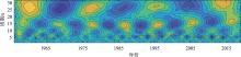
Fig. 4
Wavelet transform of rainstorm days in Shanxi Province during 1957—2019"


Fig. 5
Wavelet variance"
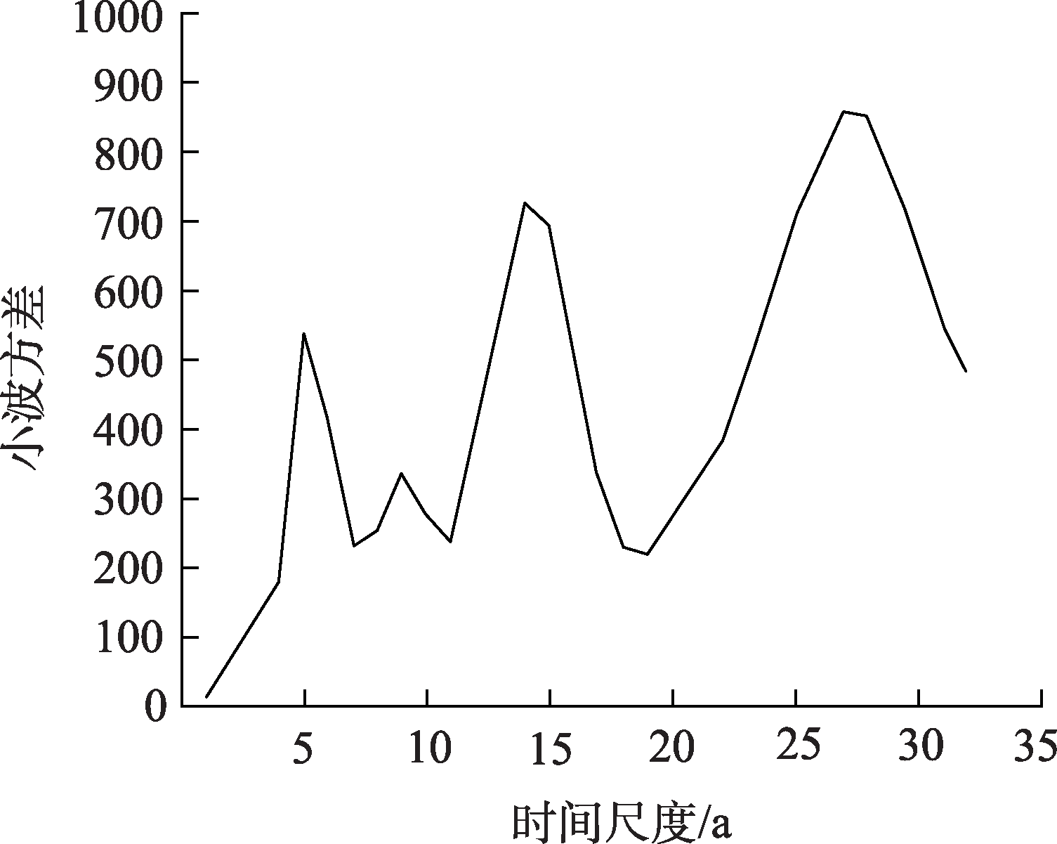
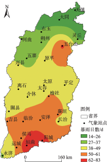
Fig. 6
Spatial distribution of rainstorm days in Shanxi Province"

Fig. 7
Cumulative rainstorm days and annual average rainstorm amount at the 27 meteorological stations"
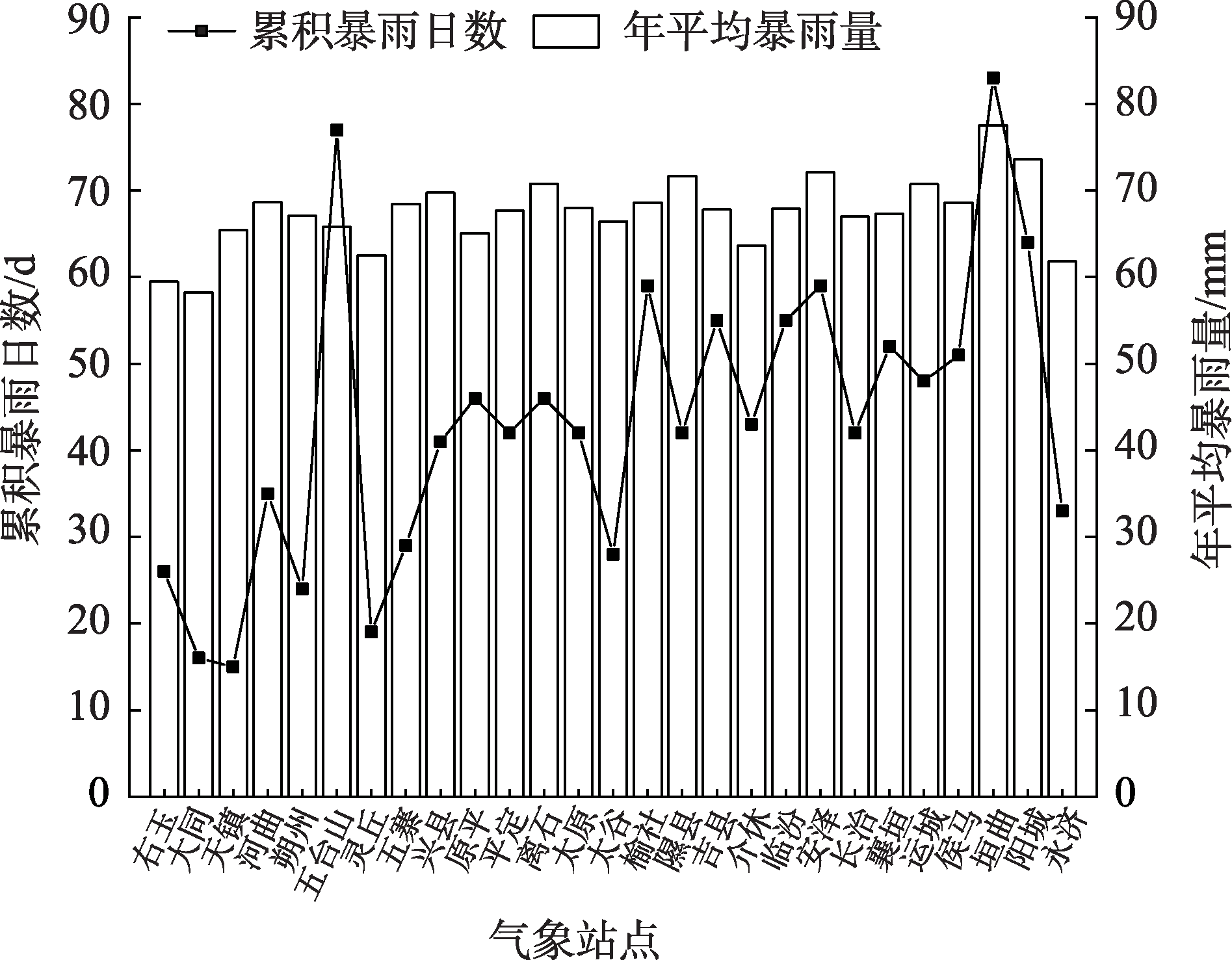
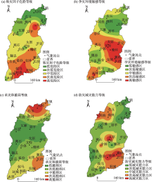
Fig. 8
Risk classification of rainstorm disaster risk in Shanxi Province"

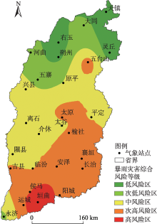
Fig. 9
Comprehensive risk classification of rainstorm disaster in Shanxi Province"

| [1] | 黄垭飞, 管兆勇, 蔡倩, 等. 近41年来江南地区暴雨洪涝灾害时空变化特征分析[J]. 气象学报, 2021, 79(4): 582-597. |
| [Huang Yafei, Guan Zhaoyong, Cai Qian, et al. Spatiotemporal variation characteristics of rainstorms and related flood disasters in Jiangnan region in the recent 41 years[J]. Acta Meteorologica Sinica, 2021, 79(4): 582-597. ] | |
| [2] | 陈颖, 马禹. 新疆不同等级暴雨洪涝灾害的时空变化特征[J]. 干旱区地理, 2021, 44(6): 1515-1524. |
| [Chen Ying, Ma Yu. Spatial and temporal characteristics of flood and rainstorm disaster in Xinjiang[J]. Arid Land Geography, 2021, 44(6): 1515-1524. ] | |
| [3] | 冯强, 王昂生, 李吉顺. 我国降水的时空变化与暴雨洪涝灾害[J]. 自然灾害学报, 1998, 7(1): 89-95. |
| [Feng Qiang, Wang Angsheng, Li Jishun. The variation of precipitation in time and space and heavy-rain flood disaster in China[J]. Journal of Natural Disasters, 1998, 7(1): 89-95. ] | |
| [4] | 黄明策. 广西暴雨时空分布特征[J]. 广西气象, 2006, 27(3): 9-13. |
| [Huang Mingce. Rainstorm space and time distributed characteristic in Guangxi[J]. Journal of Guangxi Meteorology, 2006, 27(3): 9-13. ] | |
| [5] | 卢瑞荆, 樊兰峰. 1961—2008年贵州暴雨时空分布特征[J]. 沙漠与绿洲气象, 2010, 4(3): 17-21. |
| [Lu Ruijing, Fan Lanfeng. Spatial and temporal characteristics of rainstorm in Guigzhou during 1961—2008[J]. Desert and Oasis Meteorology, 2010, 4(3): 17-21. ] | |
| [6] | 孔锋. 中国不同月份暴雨的多属性时空演变特征及区域差异(1961—2016年)[J]. 水利水电技术, 2020, 51(2): 26-37. |
| [Kong Feng. Multi-attribute spatio-temporal evolution characteristics and regional differences of heavy rainfall in different months in China from 1961 to 2016[J]. Water Resources and Hydropower Engineering, 2020, 51(2): 26-37. ] | |
| [7] | 侯春梅, 陈忠民, 康雯瑛, 等. 河南汛期暴雨时空分布特征及成因分析[J]. 气象与环境科学, 2008, 31(2): 39-42. |
| [Hou Chunmei, Chen Zhongmin, Kang Wenying, et al. Distribution and cause analysis of the flood season rainstorm in Henan Province[J]. Meteorological and Environmental Sciences, 2008, 31(2): 39-42. ] | |
| [8] |
Brooks H E, Stensrud D J. Climatology of heavy rain events in the United States from hourly precipitation observations[J]. Monthly Weather Review, 2000, 128: 1194-1201.
doi: 10.1175/1520-0493(2000)128<1194:COHREI>2.0.CO;2 |
| [9] | Hail J W, Sayers P B, Dawson R J. Nation-scale assessment of current and future flood risk in England and Wales[J]. Natural Hazards, 2005, 35(1): 147-164. |
| [10] | 丁一汇. 中国暴雨理论的发展历程与重要进展[J]. 暴雨灾害, 2019, 38(5): 395-406. |
| [Ding Yihui. The major advances and development process of the theory of heavy rainfalls in China[J]. Torrential Rain and Disasters, 2019, 38(5): 395-406. ] | |
| [11] | 赵子惜, 陈志和. 基于CMORPH融合降水的中国暴雨时空分布特征分析[J]. 人民珠江, 2020, 41(8): 41-52. |
| [Zhao Zixi, Chen Zhihe. Temporal and spatial distribution characteristics of rainstorm in China based on CMORPH integrated precipitation[J]. Pearl River, 2020, 41(8): 41-52. ] | |
| [12] |
胡畔, 陈波, 史培军. 中国暴雨洪涝灾情时空格局及影响因素[J]. 地理学报, 2021, 76(5): 1148-1162.
doi: 10.11821/dlxb202105008 |
|
[Hu Pan, Chen Bo, Shi Peijun. Spatiotemporal patterns and influencing factors of rainstorm-induced flood disasters in China[J]. Acta Geographica Sinica, 2021, 76(5): 1148-1162. ]
doi: 10.11821/dlxb202105008 |
|
| [13] |
Rahmati O, Zeinivand H, Besharat M. Flood hazard zoning in Yasooj region, Iran, using GIS and multi-criteria decision analysis[J]. Geomatics, Natural Hazards and Risk, 2016, 7(3): 1000-1017.
doi: 10.1080/19475705.2015.1045043 |
| [14] | 裴惠娟, 陈晋, 李雯, 等. 甘肃省暴雨洪水时空分布及风险评估[J]. 自然灾害学报, 2017, 26(3): 167-175. |
| [Pei Huijuan, Chen Jin, Li Wen, et al. Spatiotemporal pattern and risk assessment of storm flood in Gansu Province[J]. Journal of Natural Disasters, 2017, 26(3): 167-175. ] | |
| [15] | 杨幸, 王平, 任宾宾. 基于GIS的汉中市气象灾害风险评估[J]. 江西农业学报, 2019, 31(1): 67-77. |
| [Yang Xing, Wang Ping, Ren Binbin. Risk assessment of meteorological disasters in Hanzhong City based on GIS[J]. Acta Agriculturae Jiangxi, 2019, 31(1): 67-77. ] | |
| [16] | 周月华, 彭涛, 史瑞琴. 我国暴雨洪涝灾害风险评估研究进展[J]. 暴雨灾害, 2019, 38(5): 494-501. |
| [Zhou Yuehua, Peng Tao, Shi Ruiqin. Research progress on risk assessment of heavy rainfall and flood disasters in China[J]. Torrential Rain and Disasters, 2019, 38(5): 494-501. ] | |
| [17] | 孙鹏. 宣城市暴雨分布规律与暴雨洪涝灾害风险评价[D]. 合肥: 合肥工业大学, 2016. |
| [Sun Peng. Evaluation of rainstorm distribution and rainstorm flood disaster risk in Xuancheng City[D]. Heifei: Heifei University of Technology, 2016. ] | |
| [18] | 刘慧, 刘波, 许霞, 等. 基于突变理论的湖南衡阳暴雨灾害风险评估[J]. 灾害学, 2019, 34(3): 221-226. |
| [Liu Hui, Liu Bo, Xu Xia, et al. Risk assessment of rainstorm disaster based on catastrophe in Hengyang of Hunan Province[J]. Journal of Catastrophology, 2019, 34(3): 221-226. ] | |
| [19] | Haruyama S, Ohokura H, Simking T, et al. Geomorphological zoning for flood inundation using satellite data[J]. GeoJournal, 1996, 38(3): 273-278. |
| [20] | 张丽花, 延军平, 陈利民. 近52年山西暴雨气候变化特征分析[J]. 自然灾害学报, 2014, 23(4): 142-148. |
| [Zhang Lihua, Yan Junping, Chen Limin. Characteristic analysis of rainstorm climate change in Shanxi Province during recent 52 years[J]. Journal of Natural Disasters, 2014, 23(4): 142-148. ] | |
| [21] | 袁瑞强, 王亚楠, 王鹏, 等. 降水集中度的变化特征及影响因素分析——以山西为例[J]. 气候变化研究进展, 2018, 14(1): 11-20. |
| [Yuan Ruiqiang, Wang Ya’nan, Wang Peng, et al. An analysis of precipitation concentration variation characteristic and influential factors in Shanxi Province, China[J]. Climate Change Research, 2018, 14(1): 11-20. ] | |
| [22] | 王文娟, 李丽平. 山西省主要气象灾害特征及风险评估——基于暴雨洪涝灾害气象数据融合的实证视角[J]. 科技导报, 2017, 35(8): 81-87. |
| [Wang Wenjuan, Li Liping. Main meteorological disasters and risk assessment in Shanxi Province: Based on empirical analysis of rainstorm and flood disaster data[J]. Science & Technology Review, 2017, 35(8): 81-87. ] | |
| [23] |
赵彩萍, 周晋红, 李兆奇, 等. 城市化对太原暴雨变化的影响[J]. 干旱气象, 2019, 37(1): 109-118.
doi: 10.11755/j.issn.1006-7639(2019)-01-0109 |
|
[Zhao Caiping, Zhou Jinhong, Li Zhaoqi, et al. Influence of urbanization on the change of rainstorm in Taiyuan[J]. Journal of Arid Meteorology, 2019, 37(1): 109-118. ]
doi: 10.11755/j.issn.1006-7639(2019)-01-0109 |
|
| [24] |
苗爱梅, 王洪霞, 武捷. 山西不同历时强降水的统计特征及趋势变化[J]. 高原气象, 2020, 39(4): 796-807.
doi: 10.7522/j.issn.1000-0534.2019.00069 |
|
[Miao Aimei, Wang Hongxia, Wu Jie. Statistical characteristic and trend change of different duration short-duration heavy rainfall in Shanxi Province[J]. Plateau Meteorology, 2020, 39(4): 796-807. ]
doi: 10.7522/j.issn.1000-0534.2019.00069 |
|
| [25] | 山西省统计局. 山西省2019年国民经济与社会发展统计公报[M]. 北京: 中国统计出版社, 2019. |
| [Shanxi Statistical Bureau. Statistical bulletin on national economy and social development of Shanxi Province[M]. Beijing: China Statistics Press, 2019. ] | |
| [26] | 山西省统计局. 山西统计年鉴[M]. 北京: 中国统计出版社, 1957—2019. |
| [Shanxi Statistical Bureau. Shanxi statistical yearbook[M]. Beijing: China Statistics Press, 1957—2019. ] | |
| [27] | 李晓虹, 苏占胜, 纳丽, 等. 贺兰山东麓暴雨气候特征及灾害防御对策[J]. 干旱区地理, 2021, 44(5): 1231-1239. |
| [Li Xiaohong, Su Zhansheng, Na Li, et al. Climate characteristics of rainstorm and disaster prevention countermeasures along eastern Helan Mountain[J]. Arid Land Geography, 2021, 44(5): 1231-1239. ] | |
| [28] | 张应华, 宋献方. 水文气象序列趋势分析与变异诊断的方法及其对比[J]. 干旱区地理, 2015, 38(4): 652-665. |
| [Zhang Yinghua, Song Xianfang. Techniques of abrupt change detection and trends analysis in hydroclimatic time-series: Advance and evaluation[J]. Arid Land Geography, 2015, 38(4): 652-665. ] | |
| [29] | 冯禹昊, 朱江玲. 基于Morlet小波的辽河径流量变化及其成因分析[J]. 水土保持研究, 2019, 26(2): 208-215. |
| [Feng Yuhao, Zhu Jiangling. Analysis on runoff change and the driving force of the Liaohe River Basin based on wavelet Moelet[J]. Research of Soil and Water Conservation, 2019, 26(2): 208-215. ] | |
| [30] | 康丽玮. 陕西秦岭南北地区暴雨时空分布与暴雨灾害风险评估[D]. 西安: 陕西师范大学, 2014. |
| [Kang Liwei. Spatial-temporal distribution of rainstorm and risk assessment of rainstorm disaster in northern and southern Qinling Mountains of Shaanxi Province[D]. Xi’an: Shaanxi Normal University, 2014. ] | |
| [31] | 周轶, 陈柳彤, 黄靖玲, 等. 典型降雨情景下北京市十渡镇山洪灾害风险评估[J]. 灾害学, 2021, 36(3): 97-102. |
| [Zhou Yi, Chen Liutong, Huang Jingling, et al. Flash flood risk assessment in Shidu, Beijing under the typical rainfall scenario[J]. Journal of Catastrophology, 2021, 36(3): 97-102. ] | |
| [32] | 李柔珂, 李耀辉, 徐影. 未来中国地区的暴雨洪涝灾害风险预估[J]. 干旱气象, 2018, 36(3): 341-352. |
| [Li Rouke, Li Yaohui, Xu Ying. Projection of rainstorm and flooding disaster in China in the 21stcentury[J]. Journal of Arid Meteorology, 2018, 36(3): 341-352. ] | |
| [33] | 刘荆, 蒋卫国, 杜培军, 等. 基于相关分析的淮河流域暴雨灾害风险评估[J]. 中国矿业大学学报, 2009, 38(5): 735-740. |
| [Liu Jing, Jiang Weiguo, Du Peijun, et al. Rainstorm risk assessment of Huaihe River based on correlation analysis[J]. Journal of China University of Mining & Technology, 2009, 38(5): 735-740. ] | |
| [34] | 王林旺. 山西省暴雨成因及时空分布研究[J]. 中国水利, 2003, 54(12): 74-75. |
| [Wang Linwang. Study on causes and spatial and temporal distribution of rainstorm in Shanxi Province[J]. China Water Resources, 2003, 54(12): 74-75. ] | |
| [35] | 魏海茹, 刘婉莉. 运城市突发气象灾害区域分析[J]. 科技情报开发与经济, 2007, 17(18): 168-169. |
| [Wei Hairu, Liu Wanli. Analysis on the burst weather disaster areas in Yuncheng City[J]. Journal of Library and Information Science, 2007, 17(18): 168-169. ] | |
| [36] | 孔锋, 方建, 吕丽莉, 等. 中国长短历时暴雨时空变化格局及其对总暴雨贡献的研究(1951—2010)[J]. 中国人口·资源与环境, 2016, 26(增刊2): 316-320. |
| [Kong Fei, Fang Jian, Lü Lili, et al. Long and short duration heavy rainfall spatio-temporal patterns change and its contribution to total heavy rainfall in China (1951—2010)[J]. China Population, Resources and Environment, 2016, 26(Suppl. 2): 316-320. ] |
| Viewed | ||||||||||||||||||||||||||||||||||||||||||||||||||
|
Full text 343
|
|
|||||||||||||||||||||||||||||||||||||||||||||||||
|
Abstract 605
|
|
|||||||||||||||||||||||||||||||||||||||||||||||||
Cited |
|
|||||||||||||||||||||||||||||||||||||||||||||||||
| Shared | ||||||||||||||||||||||||||||||||||||||||||||||||||
|
||