- Jul. 15, 2025
Arid Land Geography ›› 2021, Vol. 44 ›› Issue (1): 268-276.doi: 10.12118/j.issn.1000–6060.2021.01.28
• Regional Development • Previous Articles Next Articles
GAO Yuxiang1( ),DONG Xiaofeng2(),LIANG Ying2
Received:2020-03-10
Revised:2020-06-05
Online:2021-01-25
Published:2021-03-09
Contact:
Xiaofeng DONG
E-mail:19115056@bjtu.edu.cn;xfdong@bjtu.edu.cn
GAO Yuxiang,DONG Xiaofeng,LIANG Ying. Spatial features of road networks in Ningxia based on GIS[J].Arid Land Geography, 2021, 44(1): 268-276.

Fig. 1
Road and railway network of Ningxia in 2017"
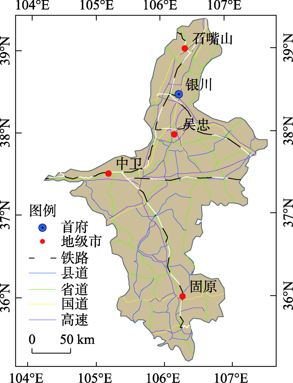
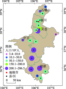
Fig. 2
Population distribution of Hui nationality of Ningxia in 2017"


Fig. 3
Indication of transfer time setting"

Tab. 1
Speed of roads and railways"
| 类型 | 铁路 | 高速 | 国道 | 省道 | 县道 |
|---|---|---|---|---|---|
| 速度/km·h-1 | 100 | 100 | 60 | 50 | 30 |
Tab. 2
Cost time and buffer width of road grid"
| 类型 | 铁路 | 高速 | 国道 | 省道 | 县道 | 其他 |
|---|---|---|---|---|---|---|
| 时间成本/min | 0.6 | 0.6 | 1.0 | 1.2 | 2.0 | 3.0 |
| 缓冲宽/m | 20 | 60 | 30 | 24 | 18 | 14 |

Fig. 4
Reachable time between counties in 2011"

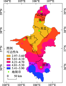
Fig. 5
Spatial accessibility of Ningxia in 2011"

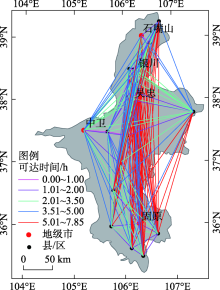
Fig. 6
Reachable time between counties in 2017"

Tab. 3
Access time between major cities /h"
| 城市 | 金凤 | 利通 | 大武口 | 沙坡头 | 原州 | 灵武 | 红寺堡 | 青铜峡 | 盐池 | 同心 | 海原 |
|---|---|---|---|---|---|---|---|---|---|---|---|
| 金凤 | - | 1.55 | 1.79 | 3.34 | 5.17 | 1.46 | 3.11 | 1.35 | 3.03 | 3.27 | 5.11 |
| 利通 | 1.29 | - | 3.04 | 2.59 | 4.03 | 0.69 | 1.46 | 0.65 | 2.53 | 2.43 | 4.07 |
| 大武口 | 1.46 | 2.24 | - | 5.03 | 7.26 | 3.09 | 4.12 | 3.03 | 4.52 | 5.66 | 7.30 |
| 沙坡头 | 3.02 | 2.38 | 3.92 | - | 3.32 | 3.55 | 1.98 | 2.49 | 3.69 | 1.92 | 3.16 |
| 原州 | 4.23 | 3.70 | 6.06 | 2.91 | - | 4.59 | 2.77 | 4.12 | 4.61 | 1.60 | 1.97 |
| 灵武 | 1.39 | 0.67 | 2.46 | 3.11 | 4.20 | - | 1.82 | 1.06 | 1.98 | 2.99 | 4.13 |
| 红寺堡 | 2.11 | 1.32 | 3.69 | 1.94 | 2.63 | 1.57 | - | 1.76 | 1.84 | 1.17 | 2.81 |
| 青铜峡 | 1.25 | 0.64 | 2.36 | 2.34 | 3.94 | 0.93 | 1.60 | - | 2.63 | 2.52 | 4.16 |
| 盐池 | 2.17 | 2.31 | 3.93 | 3.19 | 4.30 | 1.75 | 1.69 | 2.37 | - | 3.01 | 4.65 |
| 同心 | 3.18 | 2.25 | 4.17 | 1.83 | 1.50 | 2.49 | 1.10 | 2.14 | 2.97 | - | 1.64 |
| 海原 | 3.89 | 3.27 | 5.46 | 2.51 | 1.53 | 3.21 | 2.30 | 3.52 | 4.11 | 1.24 | - |
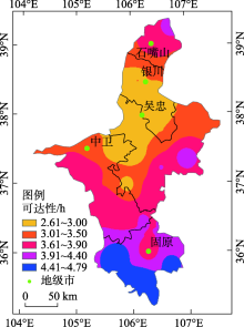
Fig. 7
Spatial accessibility of Ningxia in 2017"

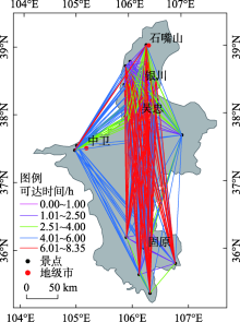
Fig. 8
Reachable time between major attractions in 2017"

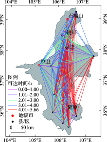
Fig. 9
Reachable time between counties in 2023"


Fig. 10
Spatial accessibility of Ningxia in 2023"
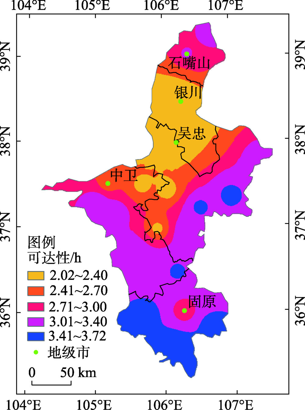

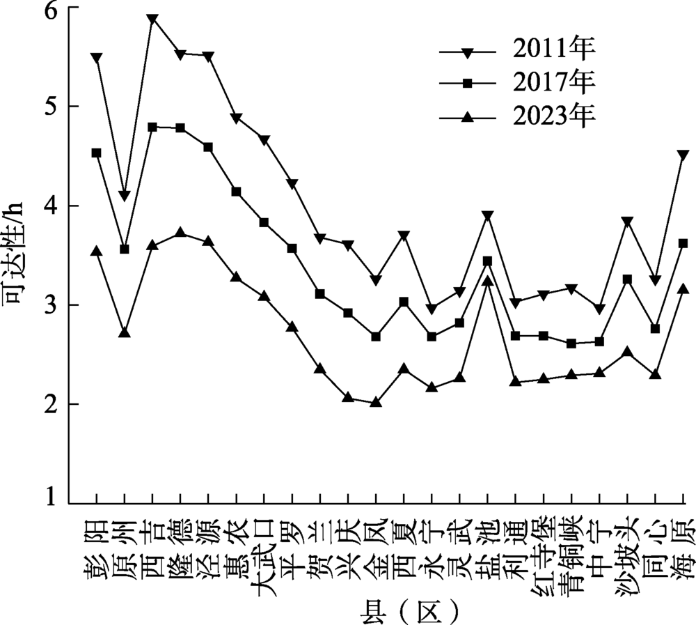
Fig. 11
Comparison of accessibility among counties"
| [1] |
Givoni M. The development and impact of the modern High Speed Train[J]. Transport Reviews, 2014,26(5):593-612.
doi: 10.1080/01441640600589319 |
| [2] | 潘稼佳. 交通可达性与旅游经济联系的空间关系分析[D]. 乌鲁木齐: 新疆大学, 2019. |
| [ Pan Jiajia. Analysis of the spatial relationship between traffic accessibility and tourism economic relationship: Taking 15 prefectures in Xinjiang as an example[D]. Urumqi: Xinjiang University, 2019. ] | |
| [3] | 钟业喜, 陆玉麒. 江苏省城镇可达性格局演变[J]. 长江流域资源与环境, 2011,20(8):903-910. |
| [ Zhong Yexi, Lu Yuqi. Urban accessibility and its structure evolution in Jiangsu Province[J]. Resources and Environment in the Yangtze Basin, 2011,20(8):903-910. ] | |
| [4] | 高玉祥, 韩峰, 李泽宇, 等. 基于GIS的轨道交通与旅游热点可达性耦合关系——以天水市为例[J]. 测绘工程, 2019,28(3):57-60, 65. |
| [ Gao Yuxiang, Han Feng, Li Zeyu, et al. Study on coupling relations of the important tourism attractions and rail transit based on GIS: A case study of Tianshui[J]. Engineering of Surveying and Mapping, 2019,28(3):57-60, 65. ] | |
| [5] | 周恺, 刘冲. 可视化交通可达性时空压缩格局的新方法——以京津冀城市群为例[J]. 经济地理, 2016,36(7):62-69. |
| [ Zhou Kai, Liu Chong. A new method to visualise the time-space compression effect in road network: A case study of Beijing-Tianjing-Hebei region[J]. Economic Geography, 2016,36(7):62-69. ] | |
| [6] |
Mostafa M, Lei Z. Incorporating spatial equity into interurban road network design[J]. Journal of Transport Geography, 2014,39(1):156-164.
doi: 10.1016/j.jtrangeo.2014.06.023 |
| [7] |
潘竟虎, 李俊峰. 中国A级旅游景点空间分布特征与可达性[J]. 自然资源学报, 2014,29(1):55-66.
doi: 10.11849/zrzyxb.2014.01.006 |
|
[ Pan Jinghu, LI Junfeng. Spatial distribution characteristics and accessibility of A-grade tourist attractions in China[J]. Journal of Natural Resources, 2014,29(1):55-66. ]
doi: 10.11849/zrzyxb.2014.01.006 |
|
| [8] |
韩艳红, 陆玉麒. 南京都市圈可达性与经济联系格局演化研究[J]. 长江流域资源与环境, 2014,23(12):1641-1648.
doi: 10.11870/cjlyzyyhj201412001 |
|
[ Han Yanhong, Lu Yuqi. Analysis of accessibility and economic linkage spatial pattern evolution of Nanjing metroplitan area[J]. Resources and Environment in the Yangtze Basin, 2014,23(12):1641-1648. ]
doi: 10.11870/cjlyzyyhj201412001 |
|
| [9] |
黄晓燕, 张爽, 曹小曙. 广州市地铁可达性时空演化及其对公交可达性的影响[J]. 地理科学进展, 2014,33(8):1078-1089.
doi: 10.11820/dlkxjz.2014.08.008 |
|
[ Huang Xiaoyan, Zhang Shuang, Cao Xiaoshu. Spatial-temporal evolution of Guangzhou subway accessibility and its effects on the accessibility of public transportation services[J]. Progress in Geography, 2014,33(8):1078-1089. ]
doi: 10.11820/dlkxjz.2014.08.008 |
|
| [10] | 高玉祥, 韩峰, 袁锋. “一带一路”节点省份铁路路网扩张时空关系研究——以甘肃省为例[J]. 铁道科学与工程学报, 2018,15(8):2172-2178. |
| [ Gao Yuxiang, Han Feng, Yuan Feng. Study on temporal-spatial relations of railway network expansion in “the Belt and Road” node province: A case study of Gansu Province[J]. Journal of Railway Science and Engineering, 2018,15(8):2172-2178. ] | |
| [11] | 魏伟, 石培基, 脱敏雍, 等. 基于GIS的甘肃省道路网密度分布特征及空间依赖度分析[J]. 地理科学, 2012,32(11):1297-1303. |
| [ Wei Wei, Shi Peiji, Tuo Minyong, et al. The road network density and its spatial dependence in Gansu Province based on GIS[J]. Scientia Geographica Sinica, 2012,32(11):1297-1303. ] | |
| [12] | 杨晓敏, 李玲琴, 付建新, 等. 30 a青海省公路可达性及县域经济联系格局演化[J]. 干旱区地理, 2018,41(6):1376-1387. |
| [ Yang Xiaomin, Li Lingqin, Fu Jianxin, et al. Pattern variation of accessibility and economic linkage at county scale in Qinghai Province from 1986 to 2016[J]. Arid Land Geography, 2018,41(6):1376-1387. ] | |
| [13] | 姚兆钊, 曹卫东, 岳洋, 等. 高铁对泛长三角地区可达性格局影响[J]. 长江流域资源与环境, 2018,27(10):2182-2193. |
| [ Yao Zhaozhao, Cao Weidong, Yue Yang, et al. Study on the influence of high-speed railway on the accessibility pattern in Pan-Yangtze river delta region[J]. Resources and Environment in the Yangtze Basin, 2018,27(10):2182-2193. ] | |
| [14] | 王雪, 白永平, 汪凡, 等. 基于街道尺度的西安市基础教育资源空间分布特征研究[J]. 干旱区地理, 2019,42(6):1470-1477. |
| [ Wang Xue, Bai Yongping, Wang Fan, et al. Characteristics of spatial distribution of basic education resources in Xi’an on street scale[J]. Arid Land Geography, 2019,42(6):1470-1477. ] | |
| [15] | 鲍超, 邹建军. 中国西北地区城镇化质量的时空变化分析[J]. 干旱区地理, 2019,42(5):1141-1152. |
| [ Bao Chao, Zou Jianjun. Spatiotemporal variations of urbanization quality in northwest China[J]. Arid Land Geography, 2019,42(5):1141-1152. ] | |
| [16] | 卢茜. 长三角地区高速公路网可达性变化与城市区位分析[D]. 上海: 上海师范大学, 2011. |
| [ Lu Qian. Analysis of accessibility change and urban location of expressway network in Yangtze River Delta[D]. Shanghai: Shanghai Normal University, 2011. ] | |
| [17] | 薛冰洁. 珠三角公路运输网络规模的合理性和发展规律研究[D]. 西安: 长安大学, 2011. |
| [ Xue Bingjie. Research on the rationality and development law of the scale of the road transportation network in the Pearl River Delta[D]. Xi’an: Chang’an University, 2011. ] | |
| [18] | 周瑞瑞. 宁夏沿黄城市群城镇化质量及时空格局演变特征研究[D]. 银川: 宁夏大学, 2017. |
| [ Zhou Ruirui. Study on urbanization quality and spatial-temporal pattern evolution characteristics of Ningxia Urban Agglomeration along the Yellow River[D]. Yinchuan: Ningxia University, 2017. ] | |
| [19] | 宁夏回族自治区统计局. 宁夏统计年鉴2018[M]. 北京: 中国统计出版社, 2018: 26-28. |
| [ Statistics Bureau of Ningxia Hui Autonomous Region. Ningxia statistical yearbook 2018[M]. Beijing: China Statistical Publishing House, 2018: 26-28. ] | |
| [20] |
Yin C, He Q, Liu Y, et al. Inequality of public health and its role in spatial accessibility to medical facilities in China[J]. Applied Geography, 2018,92(6):50-62.
doi: 10.1016/j.apgeog.2018.01.011 |
| [21] |
Williams S, Wang F H. Disparities in accessibility of public high schools, in Metropolitan Baton Rouge, Louisiana 1990—2010[J]. Urban Geography, 2014,35(7):1066-1083.
doi: 10.1080/02723638.2014.936668 |
| [22] | 肖冀星, 王振报. 基于GIS的邯郸市医疗服务设施可达性分析[J]. 测绘与空间地理信息, 2020,43(1):137-140, 144. |
| [ Xiao Jixing, Wang Zhenbao. Accessibility analysis of medical service facilities in Handan based on GIS[J]. Geomatics & Spatial Information Technology, 2020,43(1):137-140, 144. ] | |
| [23] | 马红伟. 新建包海通道西安至安康高速铁路速度目标值研究[J]. 铁道标准设计, 2019,63(3):7-11. |
| [ Ma Hongwei. Research on targeted speed of Xi’an: Ankang high-speed railway on newly built Baotou-Haikou Corridor[J]. Railway Standard Design, 2019,63(3):7-11. ] | |
| [24] | 王辉. 佳木斯至沈阳铁路客运专线速度目标值选择研究[J]. 铁道标准设计, 2017,61(9):1-5. |
| [ Wang Hui. Study on selection of target speed value for Jiamusi-Shenyang dedicated passenger railway[J]. Railway Standard Design, 2017,61(9):1-5. ] | |
| [25] |
曹小曙, 李涛, 杨文越, 等. 基于陆路交通的丝绸之路经济带可达性与城市空间联系[J]. 地理科学进展, 2015,34(6):657-664.
doi: 10.18306/dlkxjz.2015.06.001 |
|
[ Cao Xiaoshu, Li Tao, Yang Wenyue, et al. Accessibility and urban spatial connections of cities in the Silk Road Economic Belt based on land transportation[J]. Progress in Geography, 2015,34(6):657-664. ]
doi: 10.18306/dlkxjz.2015.06.001 |
|
| [26] |
朱杰, 管卫华, 蒋志欣, 等. 江苏省城市经济影响区格局变化[J]. 地理学报, 2007(10):1023-1033.
doi: 10.11821/xb200710002 |
|
[ Zhu Jie, Guan Weihua, Jiang Zhixin, et al. The evolution of urban economic effect regions in Jiangsu Province[J]. Acta Geographica Sinica, 2007(10):1023-1033. ]
doi: 10.11821/xb200710002 |
|
| [27] | 于策, 李远富, 林芳, 等. 基于GIS的津保铁路对沿线城市可达性影响分析[J]. 铁道运输与经济, 2017,39(5):18-22. |
| [ Yu Ce, Li Yuanfu, Lin Fang, et al. Analysis on Influence of Tianjin-Baoding Railway on accessibility of adjacent cities based on GIS[J]. Railway Transport and Economy, 2017,39(5):18-22. ] | |
| [28] | 高玉祥, 韩峰, 任洁, 等. “一带一路”沿线甘肃省铁路网与区域发展的耦合关系研究[J]. 铁道标准设计, 2019,63(8):46-52. |
| [ Gao Yuxiang, Han Feng, Ren Jie, et al. Study on the coupling relationship of Gansu railway network and regional development along“the Belt and Road” areas[J]. Railway Standard Design, 2019,63(8):46-52. ] | |
| [29] | 牟乃夏, 刘文宝, 王海银, 等. ArcGIS地理信息系统教程——从初学到精通[M]. 北京: 测绘出版社, 2012: 281-289. |
| [ Mu Naixia, Liu Wenbao, Wang Haiyin, et al. ArcGIS geographic information system course: From beginning to proficiency[M]. Beijing: Surveying and Mapping Publishing House, 2012: 281-289. ] |
| [1] | LU Bei, ZENG Junwei, QIAN Yongsheng, WEI Xuting, YANG Min’an, LI Haijun. Influence of road network form on urban vitality in the main urban area of Lanzhou City [J]. Arid Land Geography, 2023, 46(8): 1333-1343. |
| [2] | DONG Li, WANG Manwang, DONG Mei. Sustainable development capability of Ningxia ecological migration area based on ecological footprint method [J]. Arid Land Geography, 2023, 46(6): 1004-1012. |
| [3] | PAN Xue, GUAN Yuqi, PAN Zhandong, LIU Jie, CAI Liqun, DONG Bo, DU Jian. Spatiotemporal variation and evaluation of cultivated land quality grade in arid areas: A case of Xining City [J]. Arid Land Geography, 2023, 46(5): 793-803. |
| [4] | REN Haoke, WEI Wei, WANG Kehui. Structural evolution of tourism flow network in Ningxia under the influence of COVID-19 [J]. Arid Land Geography, 2023, 46(2): 316-324. |
| [5] | JIA Keli,LI Xiaoyu,WEI Huimin,LIU Ruiliang,LI Haoyu,YANG Siyu. Spatial differentiation and risk of land use carbon emissions in county region of Ningxia [J]. Arid Land Geography, 2023, 46(11): 1757-1767. |
| [6] | JIANG Lei, LIU Xiaolong, GUO Shuai, HE Liang, XING Jianlei, GUO Junjie. Evaluation of soil salinization susceptibility based on Logistic regression analysis: A case of Tarim irrigation area in southern Xinjiang [J]. Arid Land Geography, 2023, 46(11): 1858-1867. |
| [7] | DONG Chunyuan, HUANG Haitao, QIAO Rongrong, LUO Lihui, CHANG Xueli. Spatiotemporal variations and scale dependence of landscape diversity in oasis along the Yellow River in Ningxia [J]. Arid Land Geography, 2023, 46(1): 76-85. |
| [8] | XIE Conghui,WU Shixin,LIN Juan,ZHUANG Qingwei,ZHANG Zihui,HOU Guanyu,LUO Geping. Analysis of cultivated land salinization in Kashgar Oasis based on PSO-PNN model [J]. Arid Land Geography, 2022, 45(5): 1547-1558. |
| [9] | ZHAO Xuewei,ZHANG Zhibin,FENG Bin,GONG Weimin,MA Xiaomin,GUO Yan. Spatial differentiation and location choice of logistics enterprises in the central cities of inland northwest China: A case of Lanzhou City [J]. Arid Land Geography, 2022, 45(5): 1671-1683. |
| [10] | GAO Yang,HAN Lei,LIU Lili,WANG Nana,PENG Ling,ZHOU Peng,ZHAN Xiuli. Differences in water use strategies of Caragana korshinskii at different slopes in the east sandy land of the Yellow River in Ningxia [J]. Arid Land Geography, 2022, 45(4): 1212-1223. |
| [11] | LI Su,LIU Haonan. Spatio-temporal pattern evolution of coupling coordination between urbanization and ecological resilience in arid region: A case of Ningxia Hui Autonomous Region [J]. Arid Land Geography, 2022, 45(4): 1281-1290. |
| [12] | ZHAO Zhixin,HUO Aidi,ZHANG Dan,YI Xiu,CHEN Siming,CHEN Sibin,CHEN Jian. Assessing heat wave risk in Ningxia segment based on remote sensing [J]. Arid Land Geography, 2022, 45(2): 512-521. |
| [13] | SONG Xiaolong,MI Wenbao,LI Longtang,SONG Yongyong,ZHAO Ya’nan,YU Guoliang. Spatial mismatch of tourism economy and ecological environment system in Ningxia [J]. Arid Land Geography, 2022, 45(2): 593-605. |
| [14] | AO Yong,JIANG Lingfeng,BAI Zhaodi,YANG Xiao,ZHANG Leyi. Comprehensive evaluation of land ecological quality in the Yellow River Basin based on Grid-GIS [J]. Arid Land Geography, 2022, 45(1): 164-175. |
| [15] | TANG Yuanhang,LI Mengqi,DENG Ling,WANG Xiaoli. Glacier change and its response to climate change in Pumqu Basin during 1990—2020 [J]. Arid Land Geography, 2022, 45(1): 27-36. |
| Viewed | ||||||||||||||||||||||||||||||||||||||||||||||||||
|
Full text 249
|
|
|||||||||||||||||||||||||||||||||||||||||||||||||
|
Abstract 394
|
|
|||||||||||||||||||||||||||||||||||||||||||||||||
Cited |
|
|||||||||||||||||||||||||||||||||||||||||||||||||
| Shared | ||||||||||||||||||||||||||||||||||||||||||||||||||
|
||