- May. 12, 2025
Arid Land Geography ›› 2022, Vol. 45 ›› Issue (1): 27-36.doi: 10.12118/j.issn.1000–6060.2021.159
• Hydrology and Water Resources • Previous Articles Next Articles
TANG Yuanhang( ),LI Mengqi,DENG Ling,WANG Xiaoli()
Received:2021-04-08
Revised:2021-09-18
Online:2022-01-25
Published:2022-01-21
Contact:
Xiaoli WANG
E-mail:1204352023@qq.com;526906196@qq.com
TANG Yuanhang,LI Mengqi,DENG Ling,WANG Xiaoli. Glacier change and its response to climate change in Pumqu Basin during 1990—2020[J].Arid Land Geography, 2022, 45(1): 27-36.
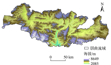
Fig. 1
Overview of the study area"

Tab. 1
Information of the remote sensing images"
| 行列号 | 获取日期 (年-月-日) | 云量/% | 获取日期 (年-月-日) | 云量/% | 获取日期 (年-月-日) | 云量/% | 获取日期 (年-月-日) | 云量/% |
|---|---|---|---|---|---|---|---|---|
| 141/40 | 1988-12-15 | 2 | 2000-11-22 | 1 | 2010-12-12 | 24 | 2020-10-20 | 4 |
| 140/40 | 1989-11-09 | 1 | 2000-11-15 | 0 | 2009-11-08 | 1 | 2020-10-29 | 1 |
| 140/41 | 1989-11-09 | 1 | 2000-10-30 | 27 | 2012-12-02 | 1 | 2020-10-22 | 11 |
| 139/41 | 1990-06-14 | 42 | 2000-12-26 | 1 | 2012-10-08 | 18 | 2020-12-16 | 1 |
Tab. 2
Area and error rate of boundary buffer zone in Pumqu Basin"
| 年份 | 缓冲区面积/km2 | 总面积/km2 | 误差率/% |
|---|---|---|---|
| 1990 | 59.09 | 1248.71 | 4.73 |
| 2000 | 58.72 | 1209.19 | 4.86 |
| 2010 | 57.08 | 1152.25 | 4.95 |
| 2020 | 55.45 | 1068.10 | 5.19 |
Tab. 3
Distribution area and variation characteristics of glaciers in Pumqu Basin during 1990—2020"
| 年份 | 面积/km2 | 退缩量/km2 | 面积变化/% | 年均面积变化/%·a-1 |
|---|---|---|---|---|
| 1990 | 1248.71 | - | - | - |
| 2000 | 1209.19 | 39.52 | -3.16 | -0.32 |
| 2010 | 1152.25 | 56.94 | -4.71 | -0.47 |
| 2020 | 1068.10 | 84.15 | -7.30 | -0.73 |
| 总计 | - | 180.61 | -15.18 | -1.52 |
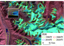
Fig. 2
Distribution characteristics of some glaciers in Pumqu Basin during 1990—2020"
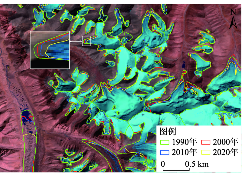

Fig. 3
Distribution areas of glaciers at different altitudes in Pumqu Basin during 1990—2020"
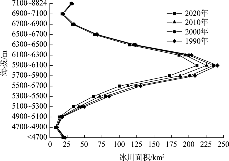
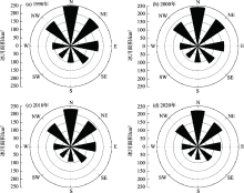
Fig. 4
Distribution areas of glaciers in different slope directions in Pumqu Basin during 1990—2020"

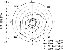
Fig. 5
Glacier retreat rates in different slope directions in Pumqu Basin during 1990—2020"

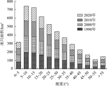
Fig. 6
Distribution areas of glaciers in different slopes in Pumqu Basin during 1990—2020"


Fig. 7
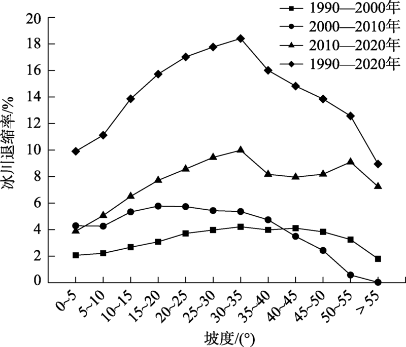
Glacial retreat rates in different slopes in Pumqu Basin during 1990—2020"
Tab. 4
Statistics on the number and area of glaciers of different sizes in Pumqu Basin in 1990 and 2020"
| 冰川规模/km2 | 1990年 | 2020年 | |||
|---|---|---|---|---|---|
| 冰川条数 | 冰川面积/km2 | 冰川条数 | 冰川面积/km2 | ||
| ≤0.2 | 285 | 29.86 | 408 | 30.94 | |
| 0.2~0.5 | 204 | 66.83 | 188 | 58.86 | |
| 0.5~1 | 119 | 86.53 | 103 | 74.70 | |
| 1~2 | 94 | 133.21 | 70 | 98.84 | |
| 2~5 | 81 | 251.95 | 67 | 192.87 | |
| 5~10 | 26 | 196.19 | 24 | 164.58 | |
| 10~20 | 6 | 87.51 | 9 | 141.04 | |
| 20~50 | 11 | 326.99 | 8 | 244.88 | |
| 50~100 | 1 | 69.63 | 1 | 61.39 | |
| 总计 | 827 | 1248.71 | 878 | 1068.10 | |
Fig. 8
Temperature and precipitation in Pumqu Basin during 1970—2017"
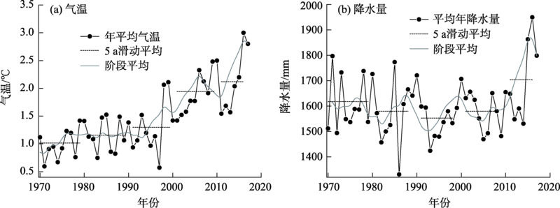

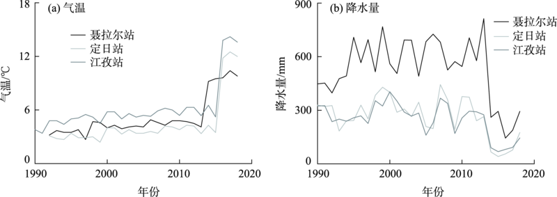
Fig. 9
Temperature and precipitation of stations near Pumqu Basin during 1990—2018"
| [1] |
林浩曦, 黄金川, 效存德, 等. 冰冻圈服务综合区划理论与方法[J]. 地理学报, 2020, 75(3):631-646.
doi: 10.11821/dlxb202003014 |
|
[Lin Haoxi, Huang Jinchuan, Xiao Cunde, et al. Theories and methods on comprehensive regionalization of cryospheric services[J]. Acta Geographica Sinica, 2020, 75(3):631-646. ]
doi: 10.11821/dlxb202003014 |
|
| [2] | 牟建新, 李忠勤, 张慧, 等. 中国西部大陆性冰川与海洋性冰川物质平衡变化及其对气候响应——以乌源1号冰川和帕隆94号冰川为例[J]. 干旱区地理, 2019, 42(1):20-28. |
| [Mou Jianxin, Li Zhongqin, Zhang Hui, et al. Mass balance variation of continental glacier and temperate glacier and their response to climate change in western China: Taking Urumqi Glacier No. 1 and Parlung No. 94 Glacier as examples[J]. Arid Land Geography, 2019, 42(1):20-28. ] | |
| [3] | 杨雪. 林芝地区冰川永久积雪地变化特征及泥石流易发性评价[D]. 成都: 成都理工大学, 2012. |
| [Yang Xue. Change characteristics of glacial permanent snow accumulation and evaluation of debris flow susceptibility in Nyingchi area[D]. Chengdu: Chengdu University of Technology, 2012. ] | |
| [4] | 童龙云, 张继, 孔应德. 西藏定日朋曲流域达仓沟冰湖溃决泥石流特征[J]. 中国地质灾害与防治学报, 2019, 30(6):34-39, 48. |
| [Tong Longyun, Zhang Ji, Kong Yingde. Characteristics of the Dacanggou Debris Flow induced by breakout of glacier-lake in the Pengqu Basin Dirin County of Tibet[J]. The Chinese Journal of Geological Hazard and Control, 2019, 30(6):34-39, 48. ] | |
| [5] | 邬光剑, 姚檀栋, 王伟财, 等. 青藏高原及周边地区的冰川灾害[J]. 中国科学院院刊, 2019, 34(11):1285-1292. |
| [Wu Guangjian, Yao Tandong, Wang Weicai, et al. Glacial hazards on Tibetan Plateau and surrounding alpines[J]. Bulletin of the Chinese Academy of Sciences, 2019, 34(11):1285-1292. ] | |
| [6] | 王秀娜, 杨太保, 田洪振, 等. 近40 a来南阿尔泰山区现代冰川变化及其对气候变化的响应[J]. 干旱区资源与环境, 2013, 27(2):77-82. |
| [Wang Xiuna, Yang Taibao, Tian Hongzhen, et al. Response of glacier variation in the southern Altai Mountains to climate change during the last 40 years[J]. Journal of Arid Land Resources and Environment, 2013, 27(2):77-82. ] | |
| [7] | 冉思红, 王晓蕾, 罗毅. 多模式预测气候变化及其对雪冰流域径流的影响[J]. 干旱区地理, 2021, 44(3):807-818. |
| [Ran Sihong, Wang Xiaolei, Luo Yi. Predicting climate change and its impact on runoff in snow-ice basin with multi-climate models[J]. Arid Land Geography, 2021, 44(3):807-818. ] | |
| [8] | 车涛, 晋锐, 李新, 等. 近20 a来西藏朋曲流域冰湖变化及潜在溃决冰湖分析[J]. 冰川冻土, 2004, 26(4):397-402. |
| [Che Tao, Jin Rui, Li Xin, et al. Glacial lakes variation and the potentially dangerous glacial lakes in the Pumqu Basin of Tibet during the last two decades[J]. Journal of Glaciology and Geocryology, 2004, 26(4):397-402. ] | |
| [9] | 魏红, 马金珠, 马明国, 等. 基于遥感与GIS的朋曲流域冰川及冰湖变化研究[J]. 兰州大学学报, 2004, 40(2):97-100. |
| [Wei Hong, Ma Jinzhu, Ma Mingguo, et al. Study on changes of glaciers and glacial lakes in the Pumqu Basin based on RS and GIS[J]. Journal of Lanzhou University, 2004, 40(2):97-100. ] | |
| [10] | 晋锐, 车涛, 李新, 等. 基于遥感和GIS的西藏朋曲流域冰川变化研究[J]. 冰川冻土, 2004, 26(3):261-266. |
| [Jin Rui, Che Tao, Li Xin, et al. Glacier variation in the Pumqu Basin derived from remote sensing data and GIS technique[J]. Journal of Glaciology and Geocryology, 2004, 26(3):261-266. ] | |
| [11] | 宋福强, 李卓卿, 肖俞, 等. 西藏朋曲河流域淡水生态系统服务价值评估[J]. 西南大学学报(自然科学版), 2018, 40(9):142-149. |
| [Song Fuqiang, Li Zhuoqing, Xiao Yu, et al. A value assessment of freshwater ecosystem services in the Pumqu River Basin, Tibet[J]. Journal of Southwest University (Natural Science Edition), 2018, 40(9):142-149. ] | |
| [12] | 贺新军. 青藏高原朋曲河流域耕地的扩张现状及其影响因素研究[D]. 重庆: 西南大学, 2020. |
| [He Xinjun. Study on the expansion status and influencing factors of cultivated land in Pengqu River Basin of Qinghai Tibet Plateau[D]. Chongqing: Southwest University, 2020. ] | |
| [13] |
冀琴, 董军, 刘睿, 等. 1990—2015年喜马拉雅山冰川变化的遥感监测及动因分析[J]. 地理科学, 2020, 40(3):486-496.
doi: 10.13249/j.cnki.sgs.2020.03.017 |
|
[Ji Qin, Dong Jun, Liu Rui, et al. Glacier changes in response to climate change in the Himalayas in 1990—2015[J]. Scientia Geographica Sinica, 2020, 40(3):486-496. ]
doi: 10.13249/j.cnki.sgs.2020.03.017 |
|
| [14] | 王聪强, 杨太保, 冀琴, 等. 1990—2015年唐古拉山中段冰川变化遥感监测[J]. 干旱区地理, 2016, 39(3):504-512. |
| [Wang Congqiang, Yang Taibao, Ji Qin, et al. Remote sensing monitoring of glacier changes in the middle region of Tanggula Mountain[J]. Arid Land Geography, 2016, 39(3):504-512. ] | |
| [15] |
Paul F, Kääb A, Maisch M, et al. The new remote-sensing-derived Swiss glacier inventory: I. Methods[J]. Annals of Glaciology, 2002, 34(1):355-361.
doi: 10.3189/172756402781817941 |
| [16] |
Huggel C, Haeberli W, Kääb A, et al. An assessment procedure for glacial hazards in the Swiss Alps[J]. Canadian Geotechnical Journal, 2004, 41(6):1068-1083.
doi: 10.1139/t04-053 |
| [17] | Andreassen L M, Paul F, Kääb A, et al. The new Landsat-derived glacier inventory for Jotunheimen, Norway, and deduced glacier changes since the 1930s[J]. The Cryosphere Discussions, 2008, 2(3):299-339. |
| [18] |
Racoviteanu A E, Arnaud Y, Williams M W, et al. Spatial patterns in glacier characteristics and area changes from 1962 to 2006 in the Kanchenjunga-Sikkim area, eastern Himalaya[J]. The Cryosphere, 2015, 9:505-523.
doi: 10.5194/tc-9-505-2015 |
| [19] |
许艾文, 杨太保, 王聪强, 等. 1978—2015年喀喇昆仑山克勒青河流域冰川变化的遥感监测[J]. 地理科学进展, 2016, 35(7):878-888.
doi: 10.18306/dlkxjz.2016.07.009 |
|
[Xu Aiwen, Yang Taibao, Wang Congqiang, et al. Variation of glaciers in the Shaksgam River Basin, Karakoram Mountains during 1978—2015[J]. Progress in Geography, 2016, 35(7):878-888. ]
doi: 10.18306/dlkxjz.2016.07.009 |
|
| [20] | 陈杰, 杨太保, 冀琴, 等. 1976—2014年爬努河流域冰川变化对气候变化的响应[J]. 干旱区资源与环境, 2015, 29(9):171-175. |
| [Chen Jie, Yang Taibao, Ji Qin, et al. Glaciers in response to climate change in the Panuhe Basin, Tibet from 1976 to 2014[J]. Journal of Arid Land Resources and Environment, 2015, 29(9):171-175. ] | |
| [21] | 胡凡盛, 杨太保, 冀琴, 等. 近40 a阿尔金山冰川与气候变化关系研究[J]. 干旱区地理, 2017, 40(3):581-588. |
| [Hu Fansheng, Yang Taibao, Ji Qin, et al. Relationship between the glacier and climate change in the Altun Mountain in recent four decades[J]. Arid Land Geography, 2017, 40(3):581-588. ] | |
| [22] | 祝合勇, 杨太保, 田洪阵. 1973—2010年阿尔金山冰川变化[J]. 地理研究, 2013, 32(8):1430-1438. |
| [Zhu Heyong, Yang Taibao, Tian Hongzhen. Glacier variation in the Altun Mountains from 1973 to 2010[J]. Geographical Research, 2013, 32(8):1430-1438. ] | |
| [23] | Cody E, Anderson B M, McColl S T, et al. Paraglacial adjustment of sediment slopes during and immediately after glacial debuttressing[J]. Geomorphology, 2020, 37(15):107-411. |
| [24] |
刘时银, 姚晓军, 郭万钦, 等. 基于第二次冰川编目的中国冰川现状[J]. 地理学报, 2015, 70(1):3-16.
doi: 10.11821/dlxb201501001 |
|
[Liu Shiyin, Yao Xiaojun, Guo Wanqin, et al. The contemporary glaciers in China based on the Second Chinese Glacier Inventory[J]. Acta Geographica Sinica, 2015, 70(1):3-16. ]
doi: 10.11821/dlxb201501001 |
|
| [25] |
Li D S, Cui B L, Wang Y, et al. Glacier extent changes and possible causes in the Hala Lake Basin of Qinghai-Tibet Plateau[J]. Journal of Mountain Science, 2019, 16(7):1571-1583.
doi: 10.1007/s11629-018-5198-5 |
| [26] | 冀琴. 1990—2015年喜马拉雅山冰川变化及其对气候波动的响应[D]. 兰州: 兰州大学, 2018. |
| [Ji Qin. Himalayan glacier change and its response to climate fluctuations from 1990 to 2015[D]. Lanzhou: Lanzhou University, 2018. ] | |
| [27] |
Xiao F, Ling F, Du Y, et al. Evaluation of spatial-temporal dynamics in surface water temperature of Qinghai Lake from 2001 to 2010 by using MODIS data[J]. Journal of Arid Land, 2013, 5(4):452-464.
doi: 10.1007/s40333-013-0188-5 |
| [28] | 魏红, 马金珠, 马明国, 等. 基于遥感与GIS的朋曲流域冰川及冰湖变化研究[J]. 兰州大学学报(自然科学版), 2004, 40(2):97-100. |
| [Wei Hong, Ma Jinzhu, Ma Mingguo, et al. Study on changes of glaciers and glacial lakes in the Pumqu Basin based on RS and GIS[J]. Journal of Chongqing Normal University (Natural Science), 2004, 40(2):97-100. ] | |
| [29] | Che T, Lin X, Liou Y A. Changes in glaciers and glacial lakes and the identification of dangerous glacial lakes in the Pumqu River Basin, Xizang (Tibet)[J]. Advances in Meteorology, 2014, 5(4):452-464. |
| [1] | XIE Junbo, WANG Xingpeng, HE Shuai, LIU Yang, ZHONG Zhibo, LI Yan, HONG Guojun. Soil salinity inversion in the Shajingzi irrigation district based on spectral index modeling [J]. Arid Land Geography, 2024, 47(7): 1199-1209. |
| [2] | LYU Na, GUO Mengjing, ZHAO Xin, LIU Kele, HUANG Yujia. Remote sensing inversion of water quality and spatiotemporal evolution characteristics of the Bosten Inland Freshwater Lake [J]. Arid Land Geography, 2024, 47(6): 953-966. |
| [3] | HUANG Manjie, LI Yanzhong, WANG Yuangang, YU Zhiguo, ZHUANG Jiacheng, XING Yincong. Evaluation of meteorological drought performance of multisource remote-sensing precipitation products in arid northwest China [J]. Arid Land Geography, 2024, 47(4): 549-560. |
| [4] | LIU Ruiliang, JIA Keli, LI Xiaoyu, CHEN Ruihua, WANG Yijing, ZHANG Junhua. Inversion of soil salt content by combining optical and microwave remote sensing in cultivated land [J]. Arid Land Geography, 2024, 47(3): 433-444. |
| [5] | WANG Jian, GUAN Yao, HE Xinghong, DAI Yunhao, CHEN Yiwei, WANG Yuqiang, LI Huiwen, FAN Debao. Dynamic monitoring and evaluation of ecological environment quality in Tumshuk City from 2000 to 2021 [J]. Arid Land Geography, 2024, 47(3): 465-473. |
| [6] | TANG Taibin, ZHOU Bao, JIN Xiaomei, WEI Sailajia, MA Tao, ZHANG Yongyan. Change of surface temperature in the source area of the Yellow River in summer [J]. Arid Land Geography, 2023, 46(8): 1250-1259. |
| [7] | CHENG Shuo, LI Yanzhong, XING Yincong, YU Zhiguo, WANG Yuangang, HUANG Manjie. Simulation performance of remote sensing precipitation products on hydrological drought characteristics in the source region of the Yellow River [J]. Arid Land Geography, 2023, 46(7): 1063-1072. |
| [8] | YANG Xuewen, WANG Ninglian, LIANG Qian, CHEN An’an. Glacier changes on the north slope of Tianshan Mountains in recent 60 years [J]. Arid Land Geography, 2023, 46(7): 1073-1083. |
| [9] | LI Shiyao, CONG Shixiang, WANG Rongrong, YU Hailong, HUANG Juying. Monitoring of maize canopy SPAD value under drought stress based on UAV multi-spectral remote sensing [J]. Arid Land Geography, 2023, 46(7): 1121-1132. |
| [10] | TIAN Liulan, WANG Shanshan, WU Zhaopeng. Construction of ecological security pattern in Urumqi based on multi-temporal remote sensing data [J]. Arid Land Geography, 2023, 46(7): 1155-1165. |
| [11] | PAN Xue, GUAN Yuqi, PAN Zhandong, LIU Jie, CAI Liqun, DONG Bo, DU Jian. Spatiotemporal variation and evaluation of cultivated land quality grade in arid areas: A case of Xining City [J]. Arid Land Geography, 2023, 46(5): 793-803. |
| [12] | DONG Jiefang, ZHANG Kaili, QU Xueshu, RUAN Zheng. Measurement and influencing factors of ecological well-being performance of cities in Yellow River Basin [J]. Arid Land Geography, 2023, 46(5): 834-845. |
| [13] | JIANG Leipeng,DING Jianli,BAO Qingling,GE Xiangyu,LIU Jingming,WANG Jinjie. Runoff estimation with low altitude remote sensing and satellite images [J]. Arid Land Geography, 2023, 46(3): 385-396. |
| [14] | LI Xinyu,WANG Jingpu,WANG Zhoulong. Research progress on aerodynamic roughness [J]. Arid Land Geography, 2023, 46(3): 407-417. |
| [15] | JI Qin, ZHANG Cuilan, DING Yuekai, CAO Xiangqin, LIANG Wenli. Glacier monitoring in Qomolangma Nature Reserve based on multi-source remote sensing data [J]. Arid Land Geography, 2023, 46(10): 1591-1601. |
| Viewed | ||||||||||||||||||||||||||||||||||||||||||||||||||
|
Full text 219
|
|
|||||||||||||||||||||||||||||||||||||||||||||||||
|
Abstract 589
|
|
|||||||||||||||||||||||||||||||||||||||||||||||||
Cited |
|
|||||||||||||||||||||||||||||||||||||||||||||||||
| Shared | ||||||||||||||||||||||||||||||||||||||||||||||||||
|
||