Arid Land Geography ›› 2026, Vol. 49 ›› Issue (6): 1168-1179.doi: 10.12118/j.issn.1000-6060.2025.368
• Vegetation and Pedology • Previous Articles Next Articles
CAO Zhaolin1( ), RAN Duojuan2, SUN Aijun1,3(), LI Yunfeng1, ZHANG Hong1, MENG Fujun1, LI Guohui2, WANG Xingpeng1,3
Received:2025-06-27
Revised:2025-08-21
Online:2026-06-25
Published:2026-06-29
Contact:
SUN Aijun
E-mail:18252589720@163.com;sunaj20@lzu.edu.cn
CAO Zhaolin, RAN Duojuan, SUN Aijun, LI Yunfeng, ZHANG Hong, MENG Fujun, LI Guohui, WANG Xingpeng. Spatiotemporal variation characteristics and management model analysis of saline-alkali land in the Tarim Basin[J].Arid Land Geography, 2026, 49(6): 1168-1179.

Fig. 1
Distribution of saline-alkali land in the Tarim Basin"
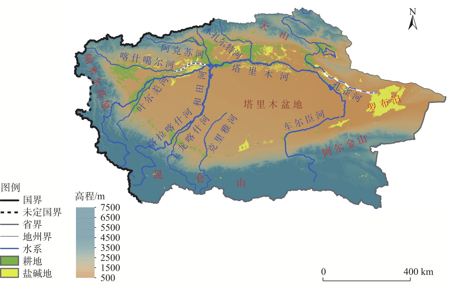
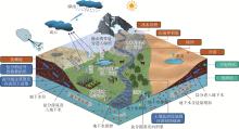
Fig. 2
Schematic diagram of the saline-alkali land formation process in the Tarim Basin"
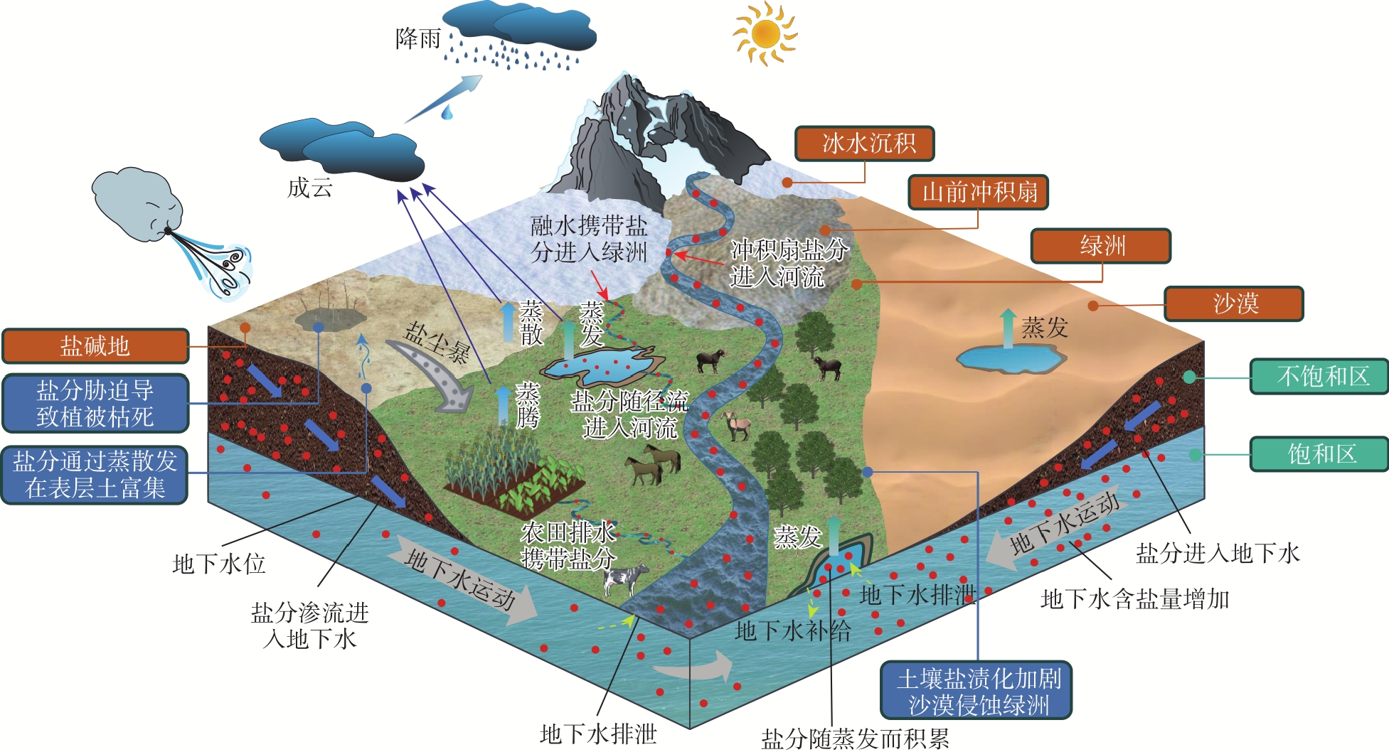
Fig. 3
Spatiotemporal dynamics of soil salinization in the Tarim Basin"
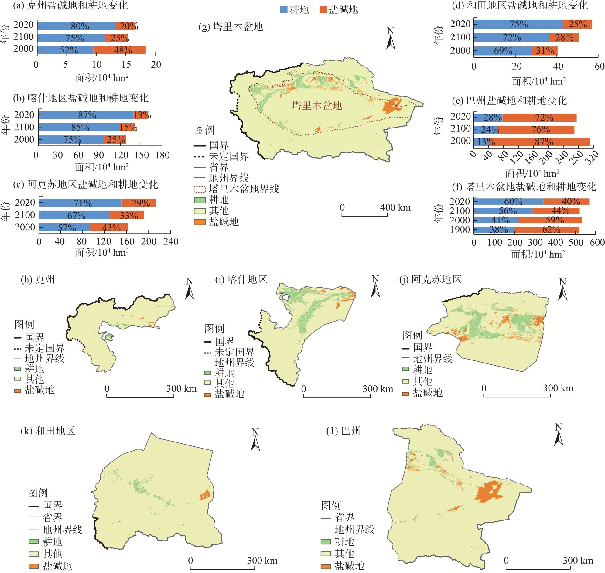
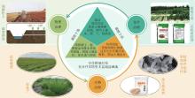
Fig. 4
Primary control measures for saline-alkali land in the Tarim Basin"

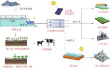
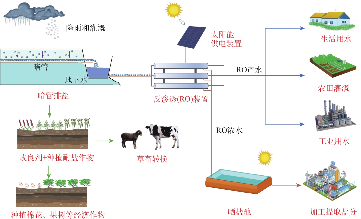
Fig. 5
Schematic diagram of comprehensive management methods for saline-alkali in the Tarim Basin"
| [1] | 赵耕毛, 杨梦圆, 陈硕, 等. 我国盐碱地治理: 现状、问题与展望[J]. 南京农业大学学报, 2025, 48(1): 14-26. |
| [Zhao Gengmao, Yang Mengyuan, Chen Shuo, et al. Saline-alkali land management in China: Current situation, problems and prospects[J]. Journal of Nanjing Agricultural University, 2025, 48(1): 14-26. ] | |
| [2] |
Zhu W, Gu S G, Jiang R, et al. Saline-alkali soil reclamation contributes to soil health improvement in China[J]. Agriculture, 2024, 14(8): 1-25.
doi: 10.3390/agriculture14010001 |
| [3] | 蔡鑫, 陈虹, 汪灏然, 等. 叶面喷施植物生长调节剂对盐碱胁迫下小麦幼苗生长及生理指标的影响[J]. 农业资源与环境学报, 2024, 41(6): 1304-1312. |
| [Cai Xin, Chen Hong, Wang Haoran, et al. Effects of foliar spraying plant growth regulator on growth and physiological indexes of wheat seedlings under saline-alkali stress[J]. Journal of Agricultural Resources and Environment, 2024, 41(6): 1304-1312. ] | |
| [4] | 冯起, 尹鑫卫, 朱猛, 等. 统筹推进西北地区盐碱地综合治理利用: 现状、挑战与对策建议[J]. 中国科学院院刊, 2024, 39(12): 2060-2073. |
| [Feng Qi, Yin Xinwei, Zhu Meng, et al. Overall promotion of integrated management and utilization of saline-alkali land in northwest China: Conditions, challenges, and recommendations[J]. Bulletin of Chinese Academy of Sciences, 2024, 39(12): 2060-2073. ] | |
| [5] | 木合塔尔·吐尔洪, 木尼热·阿布都克力木, 西崎·泰, 等. 新疆南部地区盐渍化土壤的分布及性质特征[J]. 环境科学与技术, 2008, 31(4): 22-26. |
| [Turhong Muhtar, Abudukeremu Munira, Yasushi Nishizaki, et al. Distribution and characteristics of salinized soil in the south region of Xinjiang[J]. Environmental Science & Technology, 2008, 31(4): 22-26. ] | |
| [6] | Budge E A W. The Egyptian book of the dead: The Papyrus of Ani in the British Museum[M]. Mineola: Dover Publications, 1967: 457-533. |
| [7] | Shahid S A. Developments in soil salinity assessment and reclamation: Innovative thinking and use of marginal soil and water resources in irrigated agriculture[M]. Berlin: Springer Science & Business Media, 2013: 19-38. |
| [8] | 胡书文, 李荣, 高海翔, 等. 盐碱土壤科学及综合利用[M]. 北京: 科学出版社, 2024: 1-2. |
| [Hu Shuwen, Li Rong, Gao Haixiang, et al. Saline soil science and comprehensive utilization[M]. Beijing: Science Press, 2024: 1-2. ] | |
| [9] | Shahid S A, Zaman M, Heng L. Soil salinity management in agriculture: Technological advances and applications[M]. Boca Raton: CRCPress, 2017: 485-487. |
| [10] |
贾信, 任珩, 孙平安然, 等. 盐碱地综合治理的国际研究态势分析[J]. 世界科技研究与发展, 2025, 47(1): 9-23.
doi: 10.16507/j.issn.1006-6055.2025.01.005 |
| [Jia Xin, Ren Heng, Sun Pinganran, et al. Analysis of the international research situation of integrated management of saline-alkali land[J]. World SCI-TECH R&D, 2025, 47(1): 9-23. ] | |
| [11] | 王新富, 王彦君, 周晓芳, 等. 新疆盐碱地区土壤变化情况及固碳潜力分析[J]. 中国煤炭地质, 2024, 36(5): 50-55. |
| [Wang Xinfu, Wang Yanjun, Zhou Xiaofang, et al. Analysis of soil changes and carbon sequestration potential in saline areas of Xinjiang[J]. Coal Geology of China, 2024, 36(5): 50-55. ] | |
| [12] | Li Z J, Liu H G, Wang T G, et al. Deep vertical rotary tillage depths improved soil conditions and cotton yield for saline farmland in south Xinjiang[J]. European Journal of Agronomy, 2024, 156: 127166, doi: 10.1016/j.eja.2024.127166. |
| [13] | Dai J L, Cui Z P, Zhang Y J, et al. Enhancing stand establishment and yield formation of cotton with multiple drip irrigation during emergence in saline fields of southern Xinjiang[J]. Field Crops Research, 2024, 156: 109482, doi: 10.1016/j.fcr.2024.109482. |
| [14] | 孟奇. 灌区暗管排水改良盐碱地效果监测[J]. 水科学与工程技术, 2022(4): 15-18. |
| [Meng Qi. Effect monitoring of improving saline alkali land by underground drainage in irrigation area[J]. Water Sciences and Engineering Technology, 2022(4): 15-18. ] | |
| [15] | Chen Y W, Luo F, Guan Y, et al. Influence of different application rates of FGD gypsum and aeolian sand on CO2 and N2O emissions from cotton-capsicum saline-alkali soil[J]. Frontiers in Environmental Science, 2024, 12: 1-15. |
| [16] | 王宁, 赵振勇, 张心怡, 等. 几种藜科盐生植物吸盐能力及生态学意义[J]. 植物营养与肥料学报, 2022, 28(6): 1104-1112. |
| [Wang Ning, Zhao Zhenyong, Zhang Xinyi, et al. Salt absorption capacity and ecological significance of selected Chenopodiaceae halophytes[J]. Journal of Plant Nutrition and Fertilizers, 2022, 28(6): 1104-1112. ] | |
| [17] | 祁通, 孙阳讯, 黄建, 等. 两种盐生植物在南北疆地区的适生性及吸盐能力[J]. 中国土壤与肥料, 2017(1): 144-148. |
| [Qi Tong, Sun Yangxun, Huang Jian, et al. The adaptability and salt absorption ability of two kinds of halophyte in southern and northern of Xinjiang[J]. Soil and Fertilizer Sciences in China, 2017(1): 144-148. ] | |
| [18] | Li T, Wang S N, Liu S L, et al. Trade-offs of organic amendment input on soil quality and crop productivity in saline-alkali land globally: A Meta-analysis[J]. European Journal of Agronomy, 2025, 164: 127471, doi: 10.1016/j.eja.2024.127471. |
| [19] |
孙爱军, 赵晖, 刘冰, 等. 末次冰盛期以来塔里木盆地绿洲演化研究进展与问题[J]. 干旱区地理, 2022, 45(6): 1761-1772.
doi: 10.12118/j.issn.1000-6060.2022.102 |
|
[Sun Aijun, Zhao Hui, Liu Bing, et al. Oases evolution in Tarim Basin since the Last Glacial Maximum: Progress and issues[J]. Arid Land Geography, 2022, 45(6): 1761-1772. ]
doi: 10.12118/j.issn.1000-6060.2022.102 |
|
| [20] | Wang S Q, Aihaiti A, Mamtimin A, et al. Increases in temperature and precipitation in the different regions of the Tarim River Basin between 1961 and 2021 show spatial and temporal heterogeneity[J]. Remote Sensing, 2024, 16(23): 4612, doi: 10.3390/rs16234612. |
| [21] | 魏云杰, 许模. 新疆土壤盐渍化成因及其防治对策研究[J]. 地球与环境, 2005, 33(增刊1): 593-597. |
| [Wei Yunjie, Xu Mo. Study on soil salinization and countermeasures of its prevention in Xinjiang[J]. Earth and Environment, 2005, 33(Suppl. 1): 593-597. ] | |
| [22] |
孟庆昊, 张昌民, 张祥辉, 等. 塔里木盆地现代分支河流体系形态、分布及其主控因素[J]. 岩性油气藏, 2024, 36(4): 44-56.
doi: 10.12108/yxyqc.20240405 |
|
[Meng Qinghao, Zhang Changmin, Zhang Xianghui, et al. Morphology, distribution and main controlling factors of modern distributive fluvial system in Tarim Basin[J]. Lithologic Reservoirs, 2024, 36(4): 44-56. ]
doi: 10.12108/yxyqc.20240405 |
|
| [23] | Lei S H, Jia X X, Zhao C L, et al. A review of saline-alkali soil improvements in China: Efforts and their impacts on soil properties[J]. Agricultural Water Management, 2025, 317: 109617, doi: 10.1016/j.agwat.2025.109617. |
| [24] | Zhang J Y, Xing F C, Krijgsman W, et al. Palaeogeographic reconstructions of the Eocene-Oligocene Tarim Basin (NW China): Sedimentary response to late Eocene sea retreat[J]. Palaeogeography Palaeoclimatology Palaeoecology, 2022, 587: 110796, doi: 10.1016/j.palaeo.2021.110796. |
| [25] | 李跨越, 能源, 黄少英, 等. 塔里木盆地晚奥陶世至侏罗纪不整合面分布特征及成因[J]. 沉积与特提斯地质, 2024, 44(2): 351-368. |
| [Li Kuayue, Neng Yuan, Huang Shaoying, et al. Distribution characteristics and genesis of unconformity surfaces from Late Ordovician to Jurassic in Tarim Basin[J]. Sedimentary Geology and Tethyan Geology, 2024, 44(2): 351-368. ] | |
| [26] | 张东光, 王君. 新疆塔里木河中上游水文地质概况[J]. 西部探矿工程, 2024, 36(5): 168-170. |
| [Zhang Dongguang, Wang Jun. Hydrogeological overview of the middle and upper reaches of the Tarim River in Xinjiang[J]. West-China Exploration Engineering, 2024, 36(5): 168-170. ] | |
| [27] | 鲁涵, 曾妍妍, 周金龙, 等. 塔里木盆地绿洲带地下水咸化机制[J]. 中国环境科学, 2023, 43(10): 5377-5388. |
| [Lu Han, Zeng Yanyan, Zhou Jinlong, et al. Mechanism of groundwater salinization in the oasis zone of the Tarim Basin[J]. China Environmental Science, 2023, 43(10): 5377-5388. ] | |
| [28] | Abbas A, He Q, Jin L L, et al. Spatio-temporal changes of land surface temperature and the influencing factors in the Tarim Basin, northwest China[J]. Remote Sensing, 2021, 13(19): 3792, doi: 10.3390/rs13193792. |
| [29] |
庄庆威, 吴世新, 杨怡, 等. 近10年新疆不同程度盐渍化耕地的时空变化特征[J]. 中国科学院大学学报, 2021, 38(3): 341-349.
doi: 10.7523/j.issn.2095-6134.2021.03.007 |
|
[Zhuang Qingwei, Wu Shixin, Yang Yi, et al. Spatiotemporal characteristics of different degrees of salinized cultivated land in Xinjiang in recent ten years[J]. Journal of University of Chinese Academy of Sciences, 2021, 38(3): 341-349. ]
doi: 10.7523/j.issn.2095-6134.2021.03.007 |
|
| [30] | 闫正龙, 王晓国, 高凡, 等. 塔里木河干流上游地区土壤盐渍化时空变化监测分析[J]. 干旱区资源与环境, 2010, 24(10): 105-110. |
| [Yan Zhenglong, Wang Xiaoguo, Gao Fan, et al. Monitoring analysis on spatio-temporal changes of the soil salinization in the upper stream of Tarim River[J]. Journal of Arid Land Resources and Environment, 2010, 24(10): 105-110. ] | |
| [31] | 乔木, 周生斌, 卢磊, 等. 新疆渭干河流域土壤盐渍化时空变化及成因分析[J]. 地理科学进展, 2012, 31(7): 904-910. |
| [Qiao Mu, Zhou Shengbin, Lu Lei, et al. Causes and spatial-temporal changes of aoil salinization in Weigan River Basin, Xinjiang[J]. Progress in Geography, 2012, 31(7): 904-910. ] | |
| [32] | 徐新良, 刘纪远, 张树文, 等. 中国多时期土地利用遥感监测数据集[DB/OL]. [2018]. http://www.resdc.cn/DOI. |
| [Xu Xinliang, Liu Jiyuan, Zhang Shuwen, et al. China multi-period land use remote sensing monitoring dataset[DB/OL]. [2018]. http://www.resdc.cn/DOI. ] | |
| [33] | 王弭力, 刘成林, 焦鹏程. 罗布泊盐湖钾盐矿床调查科研进展与开发现状[J]. 地质论评, 2006(6): 757-764. |
| [Wang Mili, Liu Chenglin, Jiao Pengcheng. Investigation and scientific research progress and exploitation present situation of Lop Nur salty lake potash deposits, Xinjiang, China[J]. Geological Review, 2006(6): 757-764. ] | |
| [34] | 吕宁, 石磊, 戴昱余, 等. 新疆盐碱地治理利用研究回顾与启示[J]. 灌溉排水学报, 2024, 43(12): 1-10. |
| [Lü Ning, Shi Lei, Dai Yuyu, et al. Reclamation of saline-alkali soils in Xinjiang: A review[J]. Journal of Irrigation and Drainage, 2024, 43(12): 1-10. ] | |
| [35] | 郗金标, 张福锁, 毛达如, 等. 新疆盐渍土分布与盐生植物资源[J]. 土壤通报, 2005, 36(3): 299-303. |
| [Xi Jinbiao, Zhang Fusuo, Mao Daru, et al. Saline-soil distribution and halophyte resources in Xinjiang[J]. Chinese Journal of Soil Science, 2005, 36(3): 299-303. ] | |
| [36] | 樊自立, 艾里西尔·库尔班, 徐海量, 等. 塔里木河的变迁与罗布泊的演化[J]. 第四纪研究, 2009, 29(2): 232-240. |
| [Fan Zili, Kurban Alishir, Xu Hailiang, et al. Changes of Tarim River and evolution of Lop Nur[J]. Quaternary Sciences, 2009, 29(2): 232-240. ] | |
| [37] |
Liu J, Wang S Y, Hu C M, et al. Diversity and function of soil microorganisms in response to paddy-upland rotation system in sustainable restoration of saline-sodic soils[J]. Soil Research, 2023, 61(6): 582-597.
doi: 10.1071/SR22072 |
| [38] | Li W H, Kang S Z, Du T S, et al. Optimal groundwater depth and irrigation amount can mitigate secondary salinization in water-saving irrigated areas in arid regions[J]. Agricultural Water Management, 2024, 302: 109007, doi: 10.1016/j.agwat.2024.109007. |
| [39] |
周岩, 武继承. 土壤改良剂的研究现状、问题与展望[J]. 河南农业科学, 2010(8): 152-155.
doi: 10.3969/j.issn.1004-3268.2010.08.041 |
| [Zhou Yan, Wu Jicheng. Research status, problems and prospects of soil conditioners[J]. Journal of Henan Agricultural Sciences, 2010(8): 152-155. ] | |
| [40] |
赵永敢, 王淑娟, 李彦, 等. 脱硫石膏改良盐碱土技术发展历程与展望[J]. 清华大学学报(自然科学版), 2022, 62(4): 735-745.
doi: 10.16511/j.cnki.qhdxxb.2022.25.012 |
| [Zhao Yonggan, Wang Shujuan, Li Yan, et al. Prospects of using flue gas desulfurization gypsum to ameliorate saline-alkaline soils[J]. Journal of Tsinghua University (Science and Technology), 2022, 62(4): 735-745. ] | |
| [41] | 刘易, 冯耀祖, 黄建, 等. 微咸水灌溉条件下施用不同改良剂对盐渍化土壤盐分离子分布的影响[J]. 干旱地区农业研究, 2015, 33(1): 146-152. |
| [Liu Yi, Feng Yaozu, Huang Jian, et al. Effects of modifiers on saline soil salt distribution under brackish water irrigation conditions[J]. Agricultural Research in the Arid Areas, 2015, 33(1): 146-152. ] | |
| [42] |
Afzal M, Hindawi S E S, Alghamdi S S, et al. Potential breeding strategies for improving salt tolerance in crop plants[J]. Journal of Plant Growth Regulation, 2023, 42(6): 3365-3387.
doi: 10.1007/s00344-022-10797-w |
| [43] | Wang Z Y, Tan W J, Yang D Q, et al. Mitigation of soil salinization and alkalization by bacterium-induced inhibition of evaporation and salt crystallization[J]. Science of the Total Environment, 2021, 755: 142511, doi: 10.1016/j.scitotenv.2020.142511. |
| [44] |
李科, 丁建丽, 韩礼敬, 等. 基于PlanetScope影像的典型绿洲土壤盐渍化数字制图[J]. 干旱区地理, 2023, 46(8): 1291-1302.
doi: 10.12118/j.issn.1000-6060.2022.496 |
|
[Li Ke, Ding Jianli, Han Lijing, et al. Digital mapping of soil salinization in a typical oasis based on PlanetScope images[J]. Arid Land Geography, 2023, 46(8): 1291-1302. ]
doi: 10.12118/j.issn.1000-6060.2022.496 |
|
| [45] | 陈俊英, 王新涛, 张智韬, 等. 基于无人机-卫星遥感升尺度的土壤盐渍化监测方法[J]. 农业机械学报, 2019, 50(12): 161-169. |
| [Chen Junying, Wang Xintao, Zhang Zhitao, et al. Soil salinization monitoring method based on UAV-satellite remote sensing scale-up[J]. Transactions of the Chinese Society for Agricultural Machinery, 2019, 50(12): 161-169. ] | |
| [46] |
Van S G, De V A C, Rozema J, et al. An improved methodology to evaluate crop salt tolerance from field trials[J]. Agricultural Water Management, 2019, 213: 375-387.
doi: 10.1016/j.agwat.2018.09.008 |
| [47] | 刘玉国, 杨海昌, 王开勇, 等. 新疆浅层暗管排水降低土壤盐分提高棉花产量[J]. 农业工程学报, 2014, 30(16): 84-90. |
| [Liu Yuguo, Yang Haichang, Wang Kaiyong, et al. Shallow subsurface pipe drainage in Xinjiang lowers soil salinity and improves cotton seed yield[J]. Transactions of the Chinese Society of Agricultural Engineering, 2014, 30(16): 84-90. ] | |
| [48] |
Fu F L, Wang Q. Removal of heavy metal ions from wastewaters: A review[J]. Journal of Environmental Management, 2011, 92(3): 407-418.
doi: 10.1016/j.jenvman.2010.11.011 pmid: 21138785 |
| [49] |
Meneses B B P, Perez A, Golding P. Practical design and construction of solar ponds[J]. Solar Energy, 2022, 246: 104-112.
doi: 10.1016/j.solener.2022.09.042 |
| [50] |
Saleh A, Qudeiri J A, Alnimr M A. Performance investigation of a salt gradient solar pond coupled with desalination facility near the Dead Sea[J]. Energy, 2011, 36(2): 922-931.
doi: 10.1016/j.energy.2010.12.018 |
| [51] | 万宝兴, 杨震发, 田园, 等. 耐盐碱水稻品种选育及盐碱地改良问题研究[J]. 农业科技创新, 2025(2): 27-29. |
| [Wan Baoxing, Yang Zhenfa, Tian Yuan, et al. Breeding of salt-alkaline tolerant rice varieties and strategies for saline-alkaline soil improvement[J]. The Farmers Consultant, 2025(2): 27-29. ] | |
| [52] | World Intellectual Property Organization. Green technology book: Energy solutions for climate change[M]. Switzerland: WIPO, 2024: 79-80. |
| [53] | 田长彦, 买文选, 赵振勇. 新疆干旱区盐碱地生态治理关键技术研究[J]. 生态学报, 2016, 36(22): 7064-7068. |
| [Tian Changyan, Mai Wenxuan, Zhao Zhenyong. Study on key technologies of ecological management of saline alkali land in arid area of Xinjiang[J]. Acta Ecologica Sinica, 2016, 36(22): 7064-7068. ] |
|
||