Arid Land Geography ›› 2021, Vol. 44 ›› Issue (6): 1590-1600.doi: 10.12118/j.issn.1000–6060.2021.06.08
• Earth Surface Process • Previous Articles Next Articles
WANG Xu1( ),WANG Yun2,CHEN Baoxin3,WANG Xiuqin4,LI Bin1()
Received:2021-01-04
Revised:2021-08-04
Online:2021-11-25
Published:2021-12-03
Contact:
Bin LI
E-mail:wangxu2323@vip.163.com;btlibin@126.com
WANG Xu,WANG Yun,CHEN Baoxin,WANG Xiuqin,LI Bin. Spatial and temporal distribution characteristics of intensity and frequency of wind-sand disasters in Tarim Basin[J].Arid Land Geography, 2021, 44(6): 1590-1600.
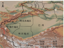
Fig. 1
Topography and administrative division of the study area"

Tab. 1
Surface-based meteorological observation stations in Tarim Basin"
| 序号 | 站号 | 站名 | 序号 | 站号 | 站名 | 序号 | 站号 | 站名 | 序号 | 站号 | 站名 |
|---|---|---|---|---|---|---|---|---|---|---|---|
| 1 | 51559 | 和静* | 11 | 51628 | 阿克苏* | 21 | 51709 | 喀什* | 31 | 51705 | 乌恰 |
| 2 | 51567 | 焉耆* | 12 | 51629 | 温宿 | 22 | 51716 | 巴楚* | 32 | 51708 | 阿克陶* |
| 3 | 51568 | 和硕* | 13 | 51633 | 拜城 | 23 | 51717 | 岳普湖 | 33 | 51711 | 阿合奇* |
| 4 | 51642 | 轮台 | 14 | 51636 | 新和 | 24 | 51802 | 英吉沙 | 34 | 51818 | 皮山 |
| 5 | 51655 | 尉犁 | 15 | 51639 | 沙雅 | 25 | 51804 | 塔什库尔干 | 35 | 51826 | 策勒 |
| 6 | 51656 | 库尔勒* | 16 | 51644 | 库车* | 26 | 51810 | 麦盖提 | 36 | 51827 | 墨玉 |
| 7 | 51765 | 铁干里克 | 17 | 51720 | 柯坪 | 27 | 51811 | 莎车 | 37 | 51828 | 和田* |
| 8 | 51777 | 若羌 | 18 | 51722 | 阿瓦提 | 28 | 51814 | 叶城 | 38 | 51829 | 洛普 |
| 9 | 51855 | 且末 | 19 | 51730 | 阿拉尔 | 29 | 51815 | 泽普 | 39 | 51839 | 民丰* |
| 10 | 51627 | 乌什 | 20 | 51707 | 伽师 | 30 | 51704 | 阿图什 | 40 | 51931 | 于田* |
Tab. 2
Weight, average and maximum values of disaster elements"
| 统计量灾情要素 | 死亡人数/人 | 倒塌房屋数/间 | 倒塌棚圈数/座 | 损坏大棚数/座 | 牲畜死亡数量/头 | 农作物受灾面积/hm2 |
|---|---|---|---|---|---|---|
| 权重 | 0.07 | 0.07 | 0.06 | 0.24 | 0.09 | 0.47 |
| 平均值 | 0.02 | 9.44 | 8.53 | 80.98 | 233.09 | 2980.50 |
| 最大值 | 3.00 | 1414.00 | 1582.00 | 3442.00 | 25580.00 | 65419.40 |
Tab. 3
Classification criteria for the intensity of wind-sand disaster"
| 百分位数S/% | 灾损指数(Z) | 风沙灾害强度等级 |
|---|---|---|
| S≤50 | Z≤0.35 | 一般(1级) |
| 50<S≤75 | 0.35<Z≤0.94 | 较重(2级) |
| 75<S≤90 | 0.94<Z≤2.31 | 严重(3级) |
| 90<S | 2.31<Z | 特重(4级) |

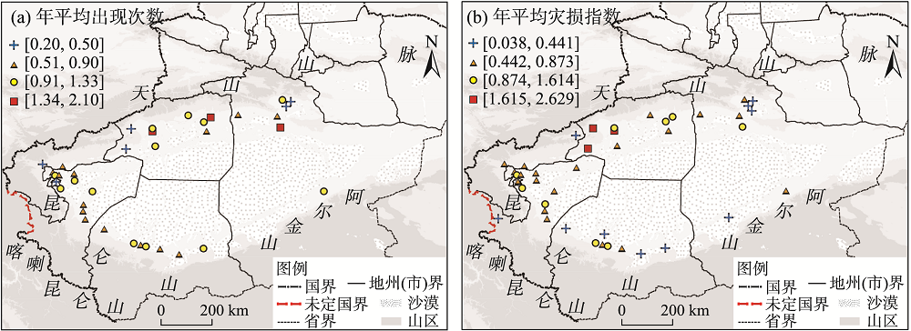
Fig. 2
Spatial distributions of the average annual occurrence and average annual damage index"
Tab. 4
Annual average number of occurrences of wind-sand disasters of level 1-4 in different regions of Tarim Basin"
| 区域平均 | 1级/次 | 2级/次 | 3级/次 | 4级/次 | 合计/次 | 百分率/% |
|---|---|---|---|---|---|---|
| 东部 | 0.39 | 0.17 | 0.12 | 0.07 | 0.75 | 22.46 |
| 北部 | 0.56 | 0.25 | 0.17 | 0.14 | 1.12 | 33.53 |
| 西部 | 0.31 | 0.21 | 0.12 | 0.07 | 0.71 | 21.26 |
| 南部 | 0.45 | 0.18 | 0.07 | 0.06 | 0.76 | 22.75 |
Tab. 5
Annual average damage index of wind-sand disasters of level 1-4 in different regions of Tarim Basin"
| 区域平均 | 1级 | 2级 | 3级 | 4级 | 合计 | 百分率/% |
|---|---|---|---|---|---|---|
| 东部 | 0.05 | 0.10 | 0.19 | 0.26 | 0.60 | 18.02 |
| 北部 | 0.06 | 0.15 | 0.22 | 1.01 | 1.44 | 43.24 |
| 西部 | 0.04 | 0.12 | 0.19 | 0.33 | 0.68 | 20.42 |
| 南部 | 0.04 | 0.11 | 0.10 | 0.36 | 0.61 | 18.32 |
Fig. 3
Spatial distributions of annual average number of occurrences of wind-sand disasters of level 1-4"
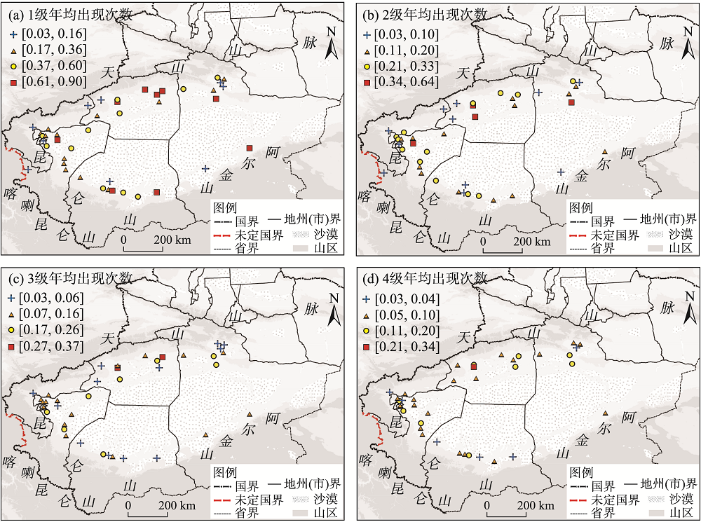
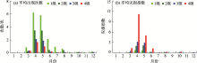
Fig. 4
Annual variation of wind-sand disasters in Tarim Basin"
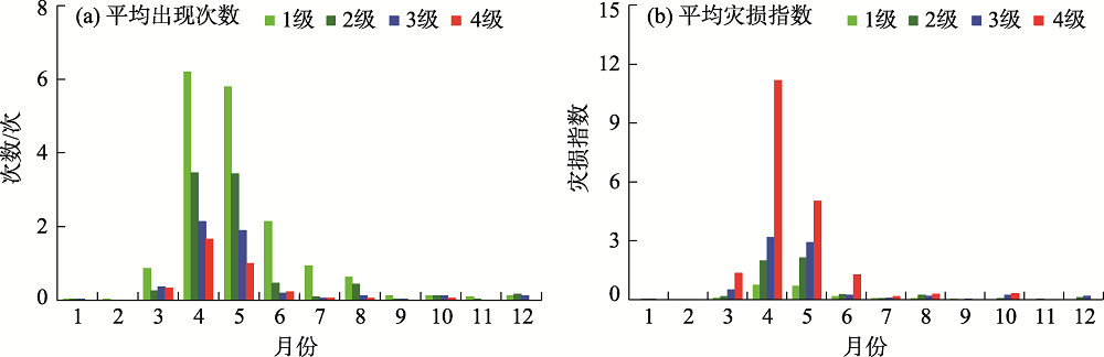
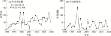
Fig. 5
Interannual variations of frequency of occurrence and disaster damage index of wind-sand disaster"
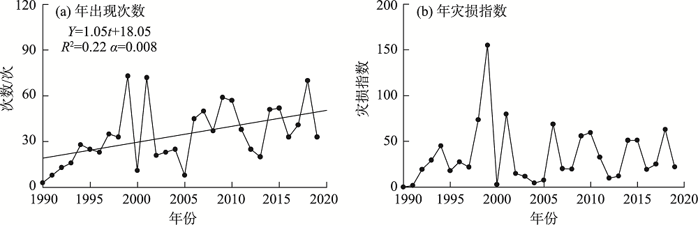

Fig. 6
Interannual variations in the number of occurrences of wind-sand disasters of level 1-4"
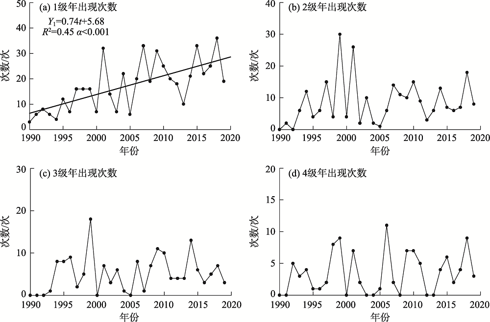
Fig. 7
Interannual variations in the disaster damage index of wind-sand disasters of level 1-4"

Fig. 8
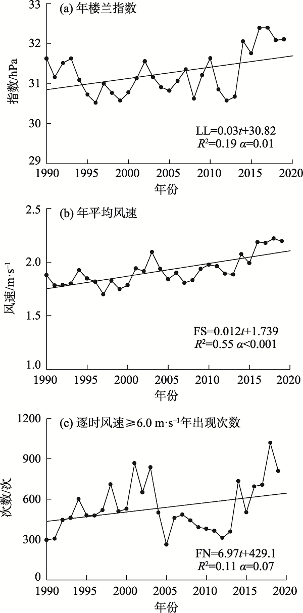
Interannual variations in the Loulan index and wind speed"
| [1] | IPCC. Climate change 2013: The physical science basis[M]. Cambridge: Cambridge University Press, 2013. |
| [2] |
Dobson A P, Bradshaw A D, Baker A J M. Hopes for the future: Restoration ecology and conservation biology[J]. Science, 1997, 277(5325):515-522.
doi: 10.1126/science.277.5325.515 |
| [3] | 魏秀菊, 王应宽, 王柳, 等. 跟踪学科前沿, 引导学科发展——《农业工程学报》的发展探索[J]. 农业工程学报, 2006, 22(3):171-175. |
| [ Wei Xiuju, Wang Yingkuan, Wang Liu, et al. Following the frontier and leading the development of agricultural engineering discipline: Exploring the development of the Transactions of the CSAE[J]. Transactions of the Chinese Society of Agricultural Engineering, 2006, 22(3):171-175. ] | |
| [4] |
Cao S X. Why large-scale afforestation efforts in China have failed to solve the desertification problem[J]. Environmental Science & Technology, 2008, 42:1826-1831.
doi: 10.1021/es0870597 |
| [5] | 魏秀菊, 胡振琪, 何蔓. 土地整理可能引发的生态环境问题及宏观管理对策[J]. 农业工程学报, 2005, 21(增刊1):127-130. |
| [ Wei Xiuju, Hu Zhenqi, He Man. Potential problems of ecological environment resulted from land rehabilitation and their macroscopic management countermeasures[J]. Transactions of the Chinese Society of Agricultural Engineering, 2005, 21(Suppl. 1):127-130. ] | |
| [6] | 张鹏, 李宁. 我国自然灾害风险分级方法的标准化[J]. 灾害学, 2014, 29(2):60-64. |
| [ Zhang Peng, Li Ning. The standardization of natural disasters risk grading methods in China[J]. Journal of Catastrophology, 2014, 29(2):60-64. ] | |
| [7] | 王涛, 陈广庭. 西部地标·中国的沙漠戈壁[M]. 上海: 上海科学技术文献出版社, 2008: 28-31. |
| [ Wang Tao, Chen Guangting. Western landmark: The desert and gobi of China[M]. Shanghai: Shanghai Science and Technology Literature Publishing House, 2008: 28-31. ] | |
| [8] | 秦越, 徐翔宇, 许凯, 等. 农业干旱灾害风险模糊评价体系及其应用[J]. 农业工程学报, 2013, 29(10):83-91. |
| [ Qin Yue, Xu Xiangyu, Xu Kai, et al. Fuzzy evaluation system of agriculture drought disaster risk and its application[J]. Transactions of the Chinese Society of Agricultural Engineering, 2013, 29(10):83-91. ] | |
| [9] | 范一大, 史培军, 周俊华, 等. 近50年来中国沙尘暴变化趋势分析[J]. 自然灾害学报, 2005, 14(3):22-26. |
| [ Fan Yida, Shi Peijun, Zhou Junhua, et al. Research on change of dust storm in China in recent 50 years[J]. Journal of Natural Disasters, 2005, 14(3):22-26. ] | |
| [10] | 周自江, 王锡稳, 牛若芸. 近47年中国沙尘暴气候特征研究[J]. 应用气象学报, 2002, 13(2):193-200. |
| [ Zhou Zijiang, Wang Xiwen, Niu Ruoyun. Climate characteristics of sandstorm in China in recent 47 years[J]. Journal of Applied Meteorological Science, 2002, 13(2):193-200. ] | |
| [11] |
Han Z W, Wang T, Sun Q W, et al. Sand harm in Taklimakan Desert highway and sand control[J]. Journal of Geographical Sciences, 2003, 13(1):45-53.
doi: 10.1007/BF02873146 |
| [12] | 王静爱, 徐伟, 史培军, 等. 2000年中国风沙灾害的时空格局与危险性评价[J]. 自然灾害学报, 2001, 10(4):1-6. |
| [ Wang Jing’ai, Xu Wei, Shi Peijun, et al. Spatio-temporal pattern and risk assessment of wind sand disaster in China in 2000[J]. Journal of Natural Disasters, 2001, 10(4):1-6. ] | |
| [13] | 徐海量, 陈亚宁. 塔里木盆地风沙灾害危险性评价[J]. 自然灾害学报, 2003, 12(2):35-39. |
| [ Xu Hailiang, Chen Yaning. Hazard assessment of wind sand disaster in Tarim Basin[J]. Journal of Natural Disasters, 2003, 12(2):35-39. ] | |
| [14] | Okada N, Tatano H, Hagihara Y, et al. Integrated research on methodological development of urban diagnosis for disaster risk and its applications[J]. Annual Report of Institute of Disaster Prevention, Kyoto University, 2004: 1-8. |
| [15] | 史培军. 三论灾害研究的理论与实践[J]. 自然灾害学报, 2002, 11(3):1-9. |
| [ Shi Peijun. Theory on disaster science and disaster dynamics[J]. Journal of Natural Disasters, 2002, 11(3):1-9. ] | |
| [16] | 王玉竹, 闫浩文, 王小平. 新疆风沙灾害风险评估[J]. 中国沙漠, 2020, 40(6):13-21. |
| [ Wang Yuzhu, Yan Haowen, Wang Xiaoping. Risk assessment of wind-sand disaster in Xinjiang, China[J]. Journal of Desert Research, 2020, 40(6):13-21. ] | |
| [17] | 管梦鸾, 张正偲, 董治宝. 风沙灾害风险评估研究进展[J]. 中国沙漠, 2018, 38(5):978-988. |
| [ Guan Mengluan, Zhang Zhengcai, Dong Zhibao. Progresses on the research of aeolian disaster risk assessment[J]. Journal of Desert Research, 2018, 38(5):978-988. ] | |
| [18] | 刘海涛, 刘海红, 韩春光, 等. 南疆大风气候特征分析[J]. 干旱区资源与环境, 2014, 28(3):148-154. |
| [ Liu Haitao, Liu Haihong, Han Chunguang, et al. Analysis on the climatic characteristics of gales in south Xinjiang[J]. Journal of Arid Land Resources and Environment, 2014, 28(3):148-154. ] | |
| [19] | 潘伯荣, 李崇舜, 刘文江. 新疆沙漠与风沙灾害治理研究[J]. 中国生态农业学报, 2001, 9(3):19-21. |
| [ Pan Borong, Li Chongshun, Liu Wenjiang. Desert and controlling of aeolian disaster in Xinjiang[J]. Chinese Journal of Eco-Agriculture, 2001, 9(3):19-21. ] | |
| [20] | 蒋富强, 李荧, 李凯崇, 等. 兰新铁路百里风区风沙流结构特性研究[J]. 铁道学报, 2010, 32(3):105-110. |
| [ Jiang fuqiang, Li Ying, Li Kaichong, et al. Study on structural characteristics of gobi wind sand flow in 100 km wind area along Lan-Xin railway[J]. Journal of the China Railway Society, 2010, 32(3):105-110. ] | |
| [21] | Jiapaer G, Chen X, Bao A M. A comparison of methods for estimating fractional vegetation cover in arid regions[J]. Agricultural & Forest Meteorology, 2011, 151(12):1698-1710. |
| [22] |
Zhang K C, Qu J J, Liao K T, et al. Damage by windblown sand and its control along Qinghai-Tibet railway in China[J]. Aeolian Research, 2010, 2:143-146.
doi: 10.1016/j.aeolia.2010.04.004 |
| [23] | 张志伟, 杨发相, 吴吉龙, 等. 新疆沙漠空间分布格局与类型结构[J]. 干旱区研究, 2014, 31(4):763-770. |
| [ Zhang Zhiwei, Yang Faxiang, Wu Jilong, et al. Spatial distribution patterns and type structure of the deserts in Xinjiang[J]. Arid Zone Research, 2014, 31(4):763-770. ] | |
| [24] | 李锋. 沙尘暴灾害风险评估指标体系初探[J]. 灾害学, 2011, 26(4):8-13, 23. |
| [ Li Feng. A preliminary discussion on risk assessment index system of sandstorm disasters[J]. Journal of Catastrophology, 2011, 26(4):8-13, 23. ] | |
| [25] | 吴美华, 王怀军, 孙桂丽, 等. 新疆农业气象灾害成因及其风险分析[J]. 干旱区地理, 2016, 39(6):1212-1220. |
| [ Wu Meihua, Wang Huaijun, Sun Guili, et al. Formation and risk analysis of meteorological disasters in Xinjiang[J]. Arid Land Geography, 2016, 39(6):1212-1220. ] | |
| [26] | 温克刚. 中国气象灾害大典·新疆卷[M]. 北京: 气象出版社, 2006: 233-273. |
| [ Wen Kegang. China meteorological disasters: Xinjiang volume[M]. Beijing: Meteorological Press, 2006: 233-273. ] | |
| [27] | 任晓, 穆桂金, 徐立帅, 等. 塔里木盆地南缘2000—2013年人工绿洲扩张特点[J]. 干旱区地理, 2015, 38(5):1022-1030. |
| [ Ren Xiao, Mu Guijin, Xu Lishuai, et al. Characteristics of artificial oasis expansion in south Tarim Basin from 2000 to 2013[J]. Arid Land Geography, 2015, 38(5):1022-1030. ] | |
| [28] | 中国气象局. 地面气象观测规范[M]. 北京: 气象出版社, 2003: 21. |
| [China Meteorological Administration. Ground meteorological observation specifications[M]. Beijing: Meteorological Press, 2003: 21. ] | |
| [29] | 陈洪武, 王旭, 马禹. 大风对新疆沙尘暴的影响[J]. 北京大学学报(自然科学版), 2003, 39(2):187-193. |
| [ Chen Hongwu, Wang Xu, Ma Yu. Effects of strong winds on sandstorms in Xinjiang[J]. Universitatis Pekinensis (Acta Scientiarum Naturalium), 2003, 39(2):187-193. ] | |
| [30] | 王昀, 王旭, 马禹, 等. 新疆农作物生长期雹灾的时空分布及危害性评估[J]. 农业工程学报, 2019, 35(6):149-157. |
| [ Wang Yun, Wang Xu, Ma Yu, et al. Spatial and temporal distribution and hazard assessment of hailstorm in Xinjiang during crop growing period[J]. Transactions of the Chinese Society of Agricultural Engineering, 2019, 36(6):149-157. ] | |
| [31] | 陈颖, 马禹. 新疆不同等级暴雨洪涝灾害的时空变化特征[J/OL]. [2021-08-21]. https://kns.cnki.net/kcms/detail/65.1103.X.20210820.1117.002.html . |
| [ Chen Ying, Ma Yu. Spatial and temporal characteristics of flood and rainstorm disaster in Xinjiang[J/OL]. [2021-08-21]. https://kns.cnki.net/kcms/detail/65.1103.X.20210820.1117.002.html . ] | |
| [32] | 张太西, 王慧, 余行杰. 新疆风灾时空分布特征分析[J]. 干旱区地理, 2021, 44(5):1281-1289. |
| [ Zhang Taixi, Wang Hui, Yu Xingjie. Spatial-temporal distribution of wind disasters in Xinjiang[J]. Arid Land Geography, 2021, 44(5):1281-1289. ] | |
| [33] | 赵清波, 李莉. 利用原始资料计算百分位数的方法[J]. 中国卫生统计, 1999, 3(16):185. |
| [ Zhao Qingbo, Li Li. Method of calculating percentiles using original data[J]. China Health Statistics, 1999, 3(16):185. ] | |
| [34] | 李乃强, 徐贵阳. 基于自然间断点分级法的土地利用数据网格化分析[J]. 测绘通报, 2020(4):106-110. |
| [ Li Naiqiang, Xu Guiyang. Grid analysis of land use based on natural breaks (jenks) classification[J]. Bulletin of Surveying and Mapping, 2020(4):106-110. ] | |
| [35] | 李冬梅, 陈春艳. 新疆沙尘天气知多少[EB/OL]. [2014-04-25]. http://www.cma.gov.cn/kppd/kppdrt/201404/t20140425_244387.html . |
| [ Li Dongmei, Chen Chunyan. How much about sand-dust weather in Xinjiang[EB/OL].[2014-04-25]. http://www.cma.gov.cn/kppd/kppdrt/201404/t20140425_244387.html .] | |
| [36] | 王玉竹, 闫浩文, 王小平, 等. 新疆大风集中程度时空特征分析[J]. 干旱区地理, 2020, 43(3):623-632. |
| [ Wang Yuzhu, Yan Haowen, Wang Xiaoping, et al. Spatio-temporal analysis of gale concentration in Xinjiang[J]. Arid Land Geography, 2020, 43(3):623-632. ] | |
| [37] | 何毅, 杨太保, 陈杰, 等. 1960—2013年南北疆风速变化特征分析[J]. 干旱区地理, 2015, 38(2):249-259. |
| [ He Yi, Yang Taibao, Chen Jie, et al. Wind speed change in north and south Xinjiang from 1960 to 2013[J]. Arid Land Geography, 2015, 38(2):249-259. ] |
|
||