Arid Land Geography ›› 2026, Vol. 49 ›› Issue (6): 1180-1191.doi: 10.12118/j.issn.1000-6060.2025.250
• Vegetation and Pedology • Previous Articles Next Articles
QU Xuebin1( ), WU Nier1(), ZHAO Yuechen2, NIU Dong3, WANG Yaying1, LIU Xin2
Received:2025-05-06
Revised:2025-07-16
Online:2026-06-25
Published:2026-06-29
Contact:
WU Nier
E-mail:qxbtd@sohu.com;wunier_317@163.com
QU Xuebin, WU Nier, ZHAO Yuechen, NIU Dong, WANG Yaying, LIU Xin. Spatiotemporal analysis and multi-scenario projections of NPP in Inner Mongolia[J].Arid Land Geography, 2026, 49(6): 1180-1191.
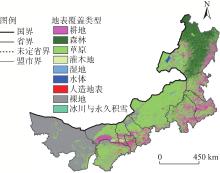
Fig. 1
Vegetation coverage types in Inner Mongolia"
Tab. 1
Basic information of CMIP6 climate models"
| 序号 | 气候模式 | 研究机构 | 国家 | 分辨率/(°) |
|---|---|---|---|---|
| 1 | ACCESS-CM2 | ACCESS | 澳大利亚 | 1.875×1.250 |
| 2 | AWI-CM-1-1-MR | AWI | 德国 | 0.938×0.938 |
| 3 | BCC-CSM2-MR | BCC、CMA | 中国 | 1.125×1.125 |
| 4 | CESM2 | NCAR | 美国 | 1.250×0.938 |
| 5 | CNRM-CM6-1-HR | CNRM | 法国 | 0.500×0.500 |
| 6 | EC-Earth3-Veg-LR | EC-Earth | 瑞典 | 1.125×1.125 |
| 7 | FGOALS-f3-L | CAS-IAP | 中国 | 2.250×1.875 |
| 8 | GFDL-ESM4 | GFDL | 美国 | 1.250×1.000 |
| 9 | MIROC6 | MIROC | 日本 | 1.406×1.406 |
| 10 | MRI-ESM2-0 | MRI | 日本 | 1.125×1.125 |
| 11 | NorESM2-MM | NCC | 挪威 | 1.250×0.938 |
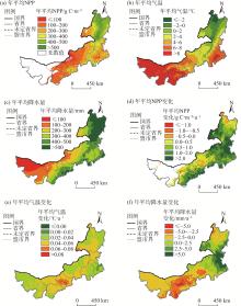
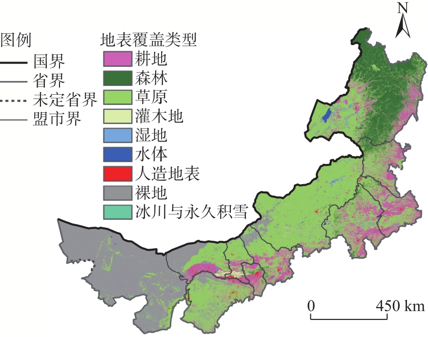
Fig. 2
Spatial distributions and variations of annual mean NPP, temperature, and precipitation in Inner Mongolia"

Tab. 2
Correlation coefficients between NPP and the top 25th percentile of monthly temperature and precipitation"
| 要素 | 1月 | 2月 | 3月 | 4月 | 5月 | 6月 | 7月 | 8月 | 9月 | 10月 | 11月 | 12月 |
|---|---|---|---|---|---|---|---|---|---|---|---|---|
| 气温 | 0.173 | 0.236 | 0.394* | 0.340* | 0.248 | 0.403* | 0.305 | 0.438* | 0.250 | 0.203 | 0.211 | 0.235 |
| 降水 | 0.307 | 0.183 | 0.261 | 0.256 | 0.346* | 0.390* | 0.472* | 0.355* | 0.328 | 0.302 | 0.309 | 0.303 |

Fig. 3
Correlation coefficients, standard deviation, and mean absolute error between the NPP-meteorological model and observed values"
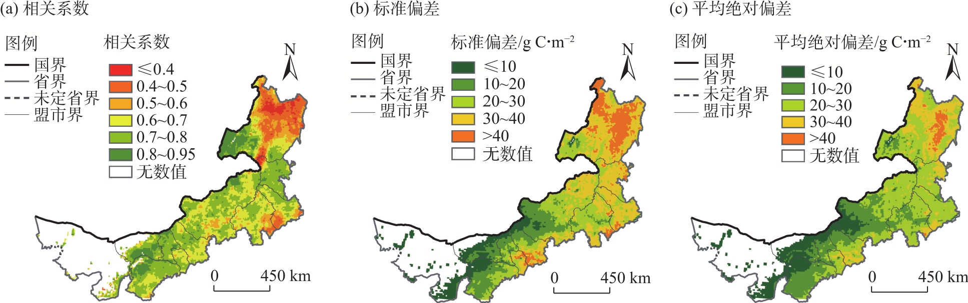
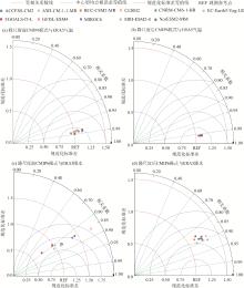
Fig. 4
Taylor diagrams of the comparative analysis between 11 CMIP6 models and ERA5 for temperature and precipitation before and after downscaling"
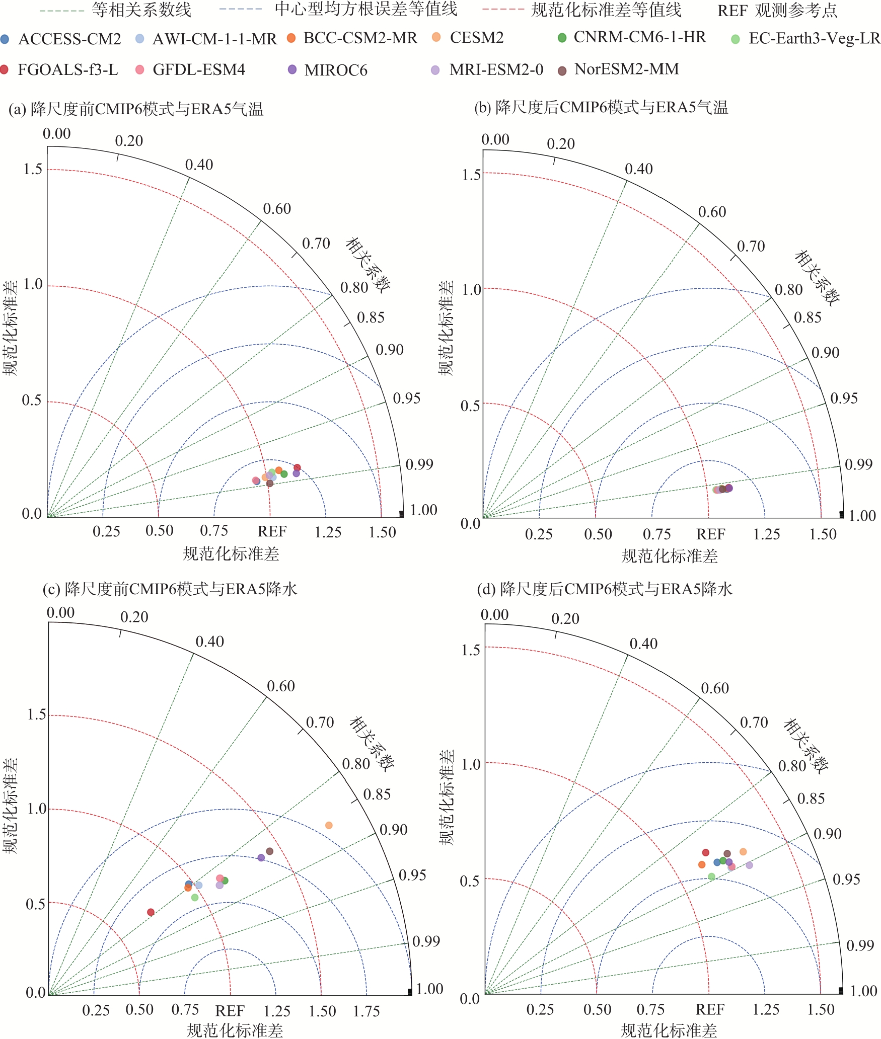
Fig. 5
Spatial distributions of annual NPP variation in Inner Mongolia under different SSP scenarios"
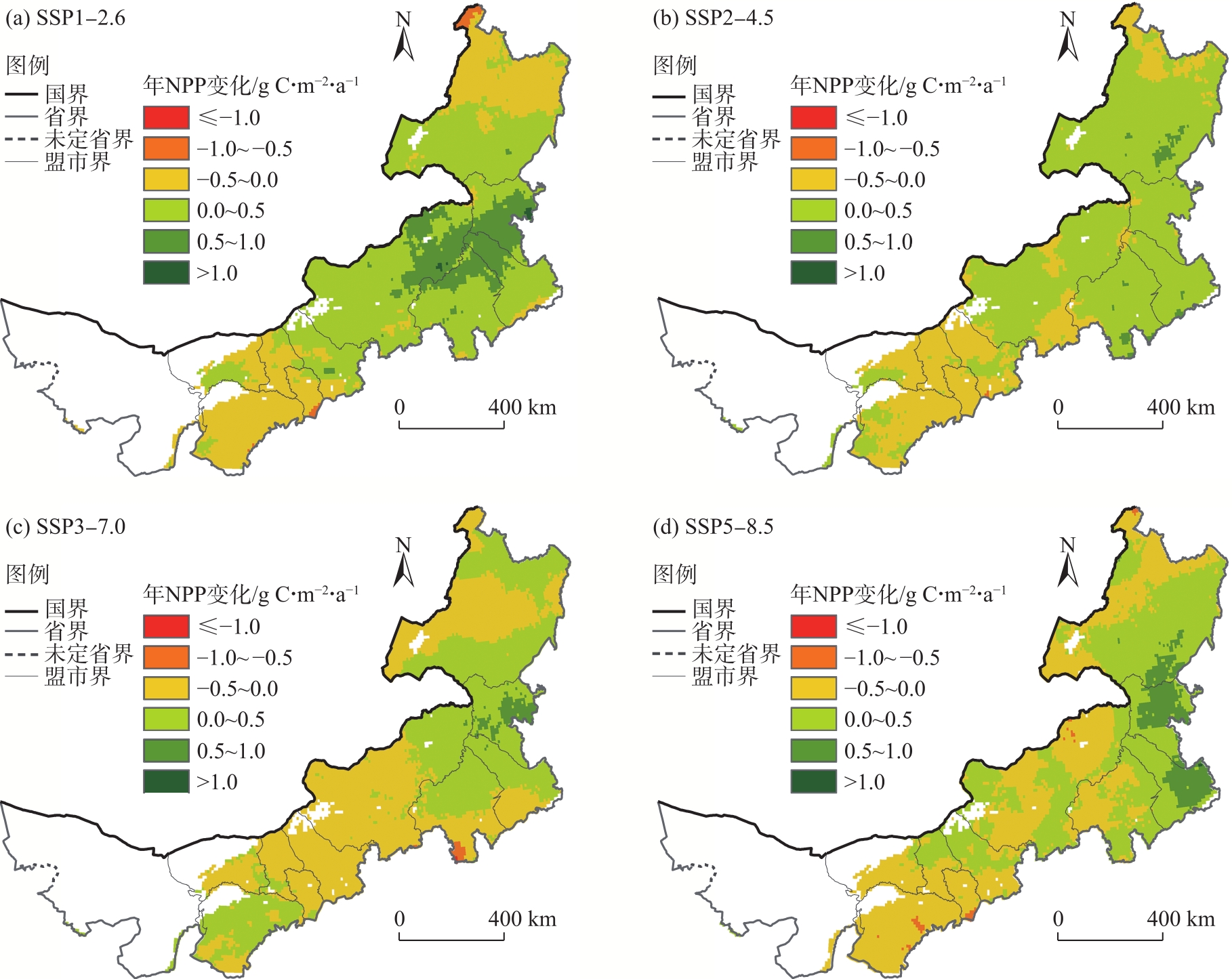
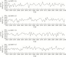
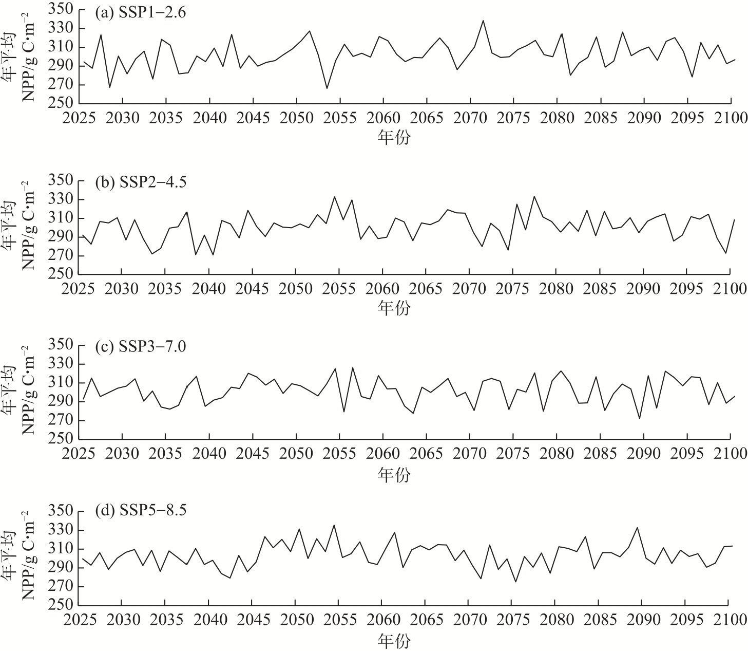
Fig. 6
Interannual variation of NPP in Inner Mongolia under different SSP scenarios"
| [1] | IPCC. Climate change 2021: The physical science basis[R]. Cambridge: Cambridge University Press, 2021. |
| [2] | Speizer S, Raymond C, Ivanovich C, et al. Concentrated and intensifying humid heat extremes in the IPCC AR6 regions[J]. Geophysical Research Letters, 2022, 49(5): e2021GL097261, doi: 10.1029/2021gl097261. |
| [3] |
陈春波, 李刚勇, 彭建. 近20 a新疆天然草地NPP时空分析[J]. 干旱区地理, 2022, 45(2): 522-534.
doi: 10.12118/j.issn.1000–6060.2021.300 |
|
[Chen Chunbo, Li Gangyong, Peng Jian. Spatiotemporal analysis of net primary productivity for natural grassland in Xinjiang in the past 20 years[J]. Arid Land Geography, 2022, 45(2): 522-534. ]
doi: 10.12118/j.issn.1000–6060.2021.300 |
|
| [4] | 曲学斌, 李丹, 田野, 等. 2001—2021年呼伦贝尔地区净生态系统生产力分布及其与气温和降水的关系[J]. 气象与环境学报, 2024, 40(4): 100-106. |
| [Qu Xuebin, Li Dan, Tian Ye, et al. Distribution of net ecosystem productivity in the Hulunbuir region from 2001 to 2021 and its relationship with temperature and precipitation[J]. Journal of Meteorology and Environment, 2024, 40(4): 100-106. ] | |
| [5] | Yu Z W, Miao L J, Liu Q, et al. Uncovering the impact of multiple determinants on vegetation NPP in Inner Mongolia[J]. Global Ecology and Conservation, 2024, 56: e03341, doi: 10.1016/j.gecco.2024.e03341. |
| [6] |
超宝, 赵媛媛, 武海岩, 等. 2000—2020年蒙古高原生态系统服务及其对气候因子的响应[J]. 干旱区地理, 2024, 47(9): 1577-1586.
doi: 10.12118/j.issn.1000-6060.2023.602 |
|
[Chao Bao, Zhao Yuanyuan, Wu Haiyan, et al. Ecosystem services and its response to climate factors in the Mongolian Plateau from 2000 to 2020[J]. Arid Land Geography, 2024, 47(9): 1577-1586. ]
doi: 10.12118/j.issn.1000-6060.2023.602 |
|
| [7] | 吴金雨, 鞠琴, 刘小妮, 等. CMIP6模式对黄河水源涵养区降水和气温模拟能力的评估[J]. 水利水运工程学报, 2023(6): 1-12. |
| [Wu Jinyu, Ju Qin, Liu Xiaoni, et al. Assessment of precipitation and temperature in the water conservation region of the Yellow River Basin using CMIP6 models[J]. Hydro-Science and Engineering, 2023(6): 1-12. ] | |
| [8] |
陈世泷, 孟庆凯, 戴勇, 等. 基于CMIP6未来情景的伊犁河流域地质灾害危险性评估预测[J]. 干旱区地理, 2025, 48(4): 599-611.
doi: 10.12118/j.issn.1000-6060.2024.520 |
|
[Chen Shilong, Meng Qingkai, Dai Yong, et al. Geological disaster hazard assessment and prediction in the Ili River Basin based on CMIP6 future scenarios[J]. Arid Land Geography, 2025, 48(4): 599-611. ]
doi: 10.12118/j.issn.1000-6060.2024.520 |
|
| [9] | 豆明玉, 段克勤, 石培宏, 等. 基于CMIP6多模式的黄土高原气温变化模拟评估及情景预估[J]. 水土保持研究, 2024, 31(2): 158-167. |
| [Dou Mingyu, Duan Keqin, Shi Peihong, et al. Historical evaluation and scenario prediction of temperature changes the Loess Plateau based on CMIP6 multimodels[J]. Research of Soil and Water Conservation, 2024, 31(2): 158-167. ] | |
| [10] | 张娇艳, 陈贞宏, 李扬, 等. CMIP6全球气候模式对贵州省降水模拟能力的评估与预估[J]. 沙漠与绿洲气象, 2024, 18(6): 47-54. |
| [Zhang Jiaoyan, Chen Zhenhong, Li Yang, et al. Evaluation and projection of simulating precipitation over Guizhou Province with CMIP6 models[J]. Desert and Oasis Meteorology, 2024, 18(6): 47-54. ] | |
| [11] | 戴君, 胡海珠, 毛晓敏, 等. 基于CMIP6多模式预估数据的石羊河流域未来气候变化趋势分析[J]. 干旱区研究, 2023, 40(10): 1-12. |
| [Dai Jun, Hu Haizhu, Mao Xiaomin, et al. Future climate change trends in Shiyang River Basin based on CMIP6 multi-model projection data[J]. Arid Zone Research, 2023, 40(10): 1-12. ] | |
| [12] | 皇彦, 宋海清, 刘朋涛. CMIP6全球气候模式对1980—2014年内蒙古降水的模拟评估[J]. 山地气象学报, 2025, 49(1): 87-95. |
| [Huang Yan, Song Haiqing, Liu Pengtao. Simulation and evaluation of the 1980—2014 precipitation in Inner Mongolia by CMIP6 global climate models[J]. Journal of Mountain Meteorology, 2025, 49(1): 87-95. ] | |
| [13] | 陈俣霏, 韩玉国, 孙明东, 等. 基于CMIP6气候模式对长江流域四川段的未来降水变化预估与分析[J]. 水土保持研究, 2024, 31(5): 288-294. |
| [Chen Yufei, Han Yuguo, Sun Mingdong, et al. Prediction and analysis of future precipitation changes in the Sichuan section of the Yangtze River Basin based on the CMIP6 climate model[J]. Research of Soil and Water Conservation, 2024, 31(5): 288-294. ] | |
| [14] | 冯椰林, 贺中华, 焦树林, 等. 基于CMIP6气候模式的贵州省极端降水情景预估[J]. 水土保持研究, 2023, 30(1): 282-290. |
| [Feng Yelin, He Zhonghua, Jiao Shulin, et al. Scenario prediction of extreme precipitation in Guizhou Province based on CMIP6 climate model[J]. Research of Soil and Water Conservation, 2023, 30(1): 282-290. ] | |
| [15] | 王一然, 韩洋, 张倩, 等. CMIP5和CMIP6模式对1950—2014年中国陆地植被碳储量的模拟评估[J]. 气候与环境研究, 2024, 29(3): 281-301. |
| [Wang Yiran, Han Yang, Zhang Qian, et al. Evaluation of China’s terrestrial vegetation carbon stocks simulated by the CMIP5 and CMIP6 models during 1950—2014[J]. Climatic and Environmental Research, 2024, 29(3): 281-301. ] | |
| [16] | 姚宏斌, 温仲明, 张添佑, 等. 基于CMIP6的中国北方草地生态系统年总初级生产力时空格局[J]. 水土保持研究, 2024, 31(4): 266-274. |
| [Yao Hongbin, Wen Zhongming, Zhang Tianyou, et al. Spatiotemporal pattern of GPP of grassland ecosystem in northern China based on CMIP6[J]. Research of Soil and Water Conservation, 2024, 31(4): 266-274. ] | |
| [17] | 任晋媛, 佟斯琴, 包玉海, 等. 内蒙古地区极端气候变化及其对植被净初级生产力的影响[J]. 生态学杂志, 2021, 40(8): 2410-2420. |
|
[Ren Jinyuan, Tong Siqin, Bao Yuhai, et al. Changes of extreme climate and its effect on net primary productivity in Inner Mongolia[J]. Chinese Journal of Ecology, 2021, 40(8): 2410-2420. ]
doi: DOI: 10.13292/j.1000-4890.202108.030 |
|
| [18] | 赵晶, 李丹. 2001—2021年内蒙古东部森林生产力和碳素利用率时空变化及其对干旱的响应[J]. 气象与环境学报, 2024, 40(6): 70-77. |
| [Zhao Jing, Li Dan. Spatiotemporal variations of productivity and carbon use efficiency of forests in eastern Inner Mongolia and their responses to drought from 2001 to 2021[J]. Journal of Meteorology and Environment, 2024, 40(6): 70-77. ] | |
| [19] | 曲学斌, 宋海清, 林聪, 等. ERA5地温数据在内蒙古地区的适用性及变化分析[J]. 土壤通报, 2025, 56(1): 59-67. |
| [Qu Xuebin, Song Haiqing, Lin Cong, et al. The applicability and variation analysis of ERA5 ground temperature in Inner Mongolia region[J]. Chinese Journal of Soil Science, 2025, 56(1): 59-67. ] | |
| [20] |
王志春, 王彦平, 徐震宇, 等. 内蒙古不同干湿区潜在蒸散发变化特征及主导因子分析[J]. 干旱区地理, 2025, 48(4): 612-622.
doi: 10.12118/j.issn.1000-6060.2024.480 |
|
[Wang Zhichun, Wang Yanping, Xu Zhenyu, et al. Changes characteristics and dominant factors of potential evapotranspiration in different dry and wet zones of Inner Mongolia[J]. Arid Land Geography, 2025, 48(4): 612-622. ]
doi: 10.12118/j.issn.1000-6060.2024.480 |
|
| [21] |
Soci C, Hersbach H, Simmons A, et al. The ERA5 global reanalysis from 1940 to 2022[J]. Quarterly Journal of the Royal Meteorological Society, 2024, 150(764): 4014-4048.
doi: 10.1002/qj.v150.764 |
| [22] |
刘婷婷, 朱秀芳, 郭锐, 等. ERA5再分析降水数据在中国的适用性分析[J]. 干旱区地理, 2022, 45(1): 66-79.
doi: 10.12118/j.issn.1000–6060.2021.132 |
|
[Liu Tingting, Zhu Xiufang, Guo Rui, et al. Applicability of ERA5 reanalysis of precipitation data in China[J]. Arid Land Geography, 2022, 45(1): 66-79. ]
doi: 10.12118/j.issn.1000–6060.2021.132 |
|
| [23] |
郭豪, 袁金国, 王景芝, 等. 基于MOD17A3的京津冀地区植被净初级生产力时空演变[J]. 长江科学院院报, 2023, 40(7): 66-72.
doi: 10.11988/ckyyb.20220164 |
| [Guo Hao, Yuan Jinguo, Wang Jingzhi, et al. Spatio-temporal evolution of net primary productivity in Beijing-Tianjin-Hebei region based on MOD17A3 data[J]. Journal of Changjiang River Scientific Research Institute, 2023, 40(7): 66-72. ] | |
| [24] | Tang R, Long H L. Quantitative assessment of NPP changes in the Yellow River source area from 2001 to 2017[J]. IOP Conference Series: Earth and Environmental Science, 2021, 687(1): 012002, doi: 10.1088/1755-1315/687/1/012002. |
| [25] |
李登科, 王钊. 基于MOD17A3的中国陆地植被NPP变化特征分析[J]. 生态环境学报, 2018, 27(3): 397-405.
doi: 10.16258/j.cnki.1674-5906.2018.03.001 |
| [Li Dengke, Wang Zhao. The characteristics of NPP of terrestrial vegetation in China based on MOD17A3 data[J]. Ecology and Environmental Sciences, 2018, 27(3): 397-405. ] | |
| [26] | 周天军, 邹立维, 陈晓龙. 第六次国际耦合模式比较计划(CMIP6)评述[J]. 气候变化研究进展, 2019, 15(5): 445-456. |
| [Zhou Tianjun, Zou Liwei, Chen Xiaolong. Commentary on the Coupled Model Intercomparison Project Phase 6 (CMIP6)[J]. Progress in Climate Change Research, 2019, 15(5): 445-456. ] | |
| [27] | 张丽霞, 陈晓龙, 辛晓歌. CMIP6情景模式比较计划(Scenario MIP)概况与评述[J]. 气候变化研究进展, 2019, 15(5): 519-525. |
| [Zhang Lixia, Chen Xiaolong, Xin Xiaoge. Short commentary on CMIP6 Scenario Model Intercomparison Project (ScenarioMIP)[J]. Climate Change Research, 2019, 15(5): 519-525. ] | |
| [28] | Wang Y X, Tian J, Feng X J, et al. Analysis of spatio-temporal changes in net primary productivity and their driving factors in ecological functional areas of the Yellow River Basin[J]. Ecological Engineering, 2024, 203: 107262, doi: 10.1016/j.ecoleng.2024.107262. |
| [29] | 赵芳芳, 徐宗学. 统计降尺度方法和Delta方法建立黄河源区气候情景的比较分析[J]. 气象学报, 2007, 65(4): 653-662. |
| [Zhao Fangfang, Xu Zongxue. Comparative analysis on downscaled climate scenarios for headwater catchment of Yellow River using SDS and Delta methods[J]. Acta Meteorologica Sinica, 2007, 65(4): 653-662. ] | |
| [30] | Mckenney D W, Pedlar J H, Lawrence K, et al. Spatial datasets of CMIP6 climate change projections for Canada and the United States[J]. Data in Brief, 2025, 58: 111246, doi: 10.1016/j.dib.2024.111246. |
| [31] |
Sime C H, Demissie T A. Performance of CMIP6 in rainfall simulation over Didessa, southwest Ethiopia[J]. Arabian Journal of Geosciences, 2025, 18(4): 93-93.
doi: 10.1007/s12517-025-12238-w |
| [32] |
宋海清, 朱仲元, 李云鹏. 陆面同化及再分析降水资料在内蒙古地区的适用性[J]. 干旱区研究, 2021, 38(6): 1624-1636.
doi: 10.13866/j.azr.2021.06.14 |
|
[Song Haiqing, Zhu Zhongyuan, Li Yunpeng. Validation of land data assimilation and reanalysis precipitation datasets over Inner Mongolia[J]. Arid Zone Research, 2021, 38(6): 1624-1636. ]
doi: 10.13866/j.azr.2021.06.14 |
|
| [33] | 张子凡, 熊茂秋, 李福杰, 等. 内蒙古草原自然资源大区植被净初级生产力时空变化及其影响因子分析[J]. 草业科学, 2022, 39(12): 2492-2502. |
| [Zhang Zifan, Xiong Maoqiu, Li Fujie, et al. Analysis of the temporal and spatial variations in net primary productivity of vegetation in the grassland region of Inner Mongolia and the factors influencing those changes[J]. Pratacultural Science, 2022, 39(12): 2492-2502. ] | |
| [34] | 籍健勋, 童新, 段利民, 等. 内蒙古河套灌区所在流域植被NPP时空动态特征及其驱动力分析[J]. 环境科学, 2025, 46(7): 4392-4402. |
| [Ji Jianxun, Tong Xin, Duan Limin, et al. Spatio-temporal dynamic characteristics and driving factors of vegetation NPP in Hetao irrigation district of Inner Mongolia[J]. Environmental Science, 2025, 46(7): 4392-4402. ] | |
| [35] | 周刊社, 杜军, 沈旭, 等. 气候变化背景下羌塘国家自然保护区植被净初级生产力时空变化[J]. 中国农业气象, 2021, 42(8): 627-641. |
| [Zhou Kanshe, Du Jun, Shen Xu, et al. Spatial and temporal variability of vegetation net primary productivity in Qiangtang National Nature Reserve under climate change[J]. Chinese Journal of Agrometeorology, 2021, 42(8): 627-641. ] | |
| [36] | 陈惺, 王军邦, 何启凡, 等. 未来气候情景下中国植被净初级生产力稳定性[J]. 全球变化数据学报, 2023, 7(2): 172-179. |
| [Chen Xing, Wang Junbang, He Qifan, et al. The dataset curation of vegetation net primary productivity and climate impacts in China in the following century[J]. Journal of Global Change Data & Discovery, 2023, 7(2): 172-179. ] | |
| [37] | 曲学斌, 王涵, 乌尼尔, 等. 4种再分析月降水数据在内蒙古地区的适用性分析[J]. 中低纬山地气象, 2023, 47(1): 75-81. |
| [Qu Xuebin, Wang Han, Wu Nier, et al. Applicability analysis of four reanalysis monthly precipitation data in Inner Mongolia[J]. Mid-low Latitude Mountain Meteorology, 2023, 47(1): 75-81. ] | |
| [38] |
滑永春, 萨如拉, 王冰. 内蒙古草原NPP时空变化及驱动力[J]. 中国沙漠, 2021, 41(5): 130-139.
doi: 10.7522/j.issn.1000-694X.2021.00074 |
|
[Hua Yongchun, Sa Rula, Wang Bing. Spatial and temporal variation of grassland NPP and its driving forces in Inner Mongolia[J]. Journal of Desert Research, 2021, 41(5): 130-139. ]
doi: 10.7522/j.issn.1000-694X.2021.00074 |
|
| [39] |
常屹冉, 张弛, 魏嘉诚, 等. 气候变化和人类活动对内蒙古植被净初级生产力的影响[J]. 草地学报, 2023, 31(11): 3444-3452.
doi: 10.11733/j.issn.1007-0435.2023.11.023 |
|
[Chang Yiran, Zhang Chi, Wei Jiacheng, et al. Impacts of climate change and human activities on the net primary productivity of vegetation in Inner Mongolia[J]. Acta Agrestia sinica, 2023, 31(11): 3444-3452. ]
doi: 10.11733/j.issn.1007-0435.2023.11.023 |
|
||