干旱区地理 ›› 2025, Vol. 48 ›› Issue (10): 1721-1735.doi: 10.12118/j.issn.1000-6060.2024.790 cstr: 32274.14.ALG2024790
阿迪力江·帕尔合提1,2( ), 李刚勇1,2, 陈春波2,3,4(), 彭建1,2
收稿日期:2024-12-26
修回日期:2025-01-27
出版日期:2025-10-25
发布日期:2025-10-27
通讯作者:
陈春波(1985-),男,博士,高级工程师,主要从事天然草地智能感知诊断等方面的研究. E-mail: ccb_8586@ms.xjb.ac.cn作者简介:阿迪力江·帕尔合提(2000-),男,本科,主要从事资源环境遥感研究. E-mail: a15292895767@126.com
基金资助:
Adiljan PARHAT1,2(), LI Gangyong1,2, CHEN Chunbo2,3,4(), PENG Jian1,2
Received:2024-12-26
Revised:2025-01-27
Published:2025-10-25
Online:2025-10-27
摘要:
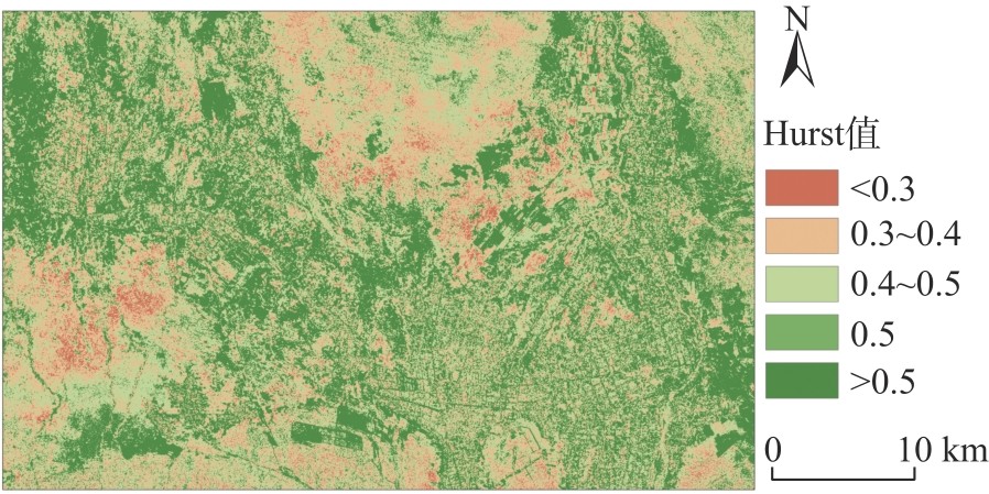
生境质量是评估生态环境优劣的综合指标,反映水、土、气、生等多要素的耦合状态。荒漠化遥感生态指数(Desertification remote sensing ecological index,DRSEI)作为多指标评价模型,可定量分析干旱区人类活动(如资源开发与保护)对生境质量的影响。针对昆仑山北坡绿洲荒漠关键带,采用DRSEI探究了2004—2021年于田绿洲生境质量时空变化特征。结果表明:(1) 总体上,于田绿洲生境质量表现为波动递增趋势,DRSEI从2004年0.3545上升至2021年0.3953,增加了0.0408(+11.5%),优良DRSEI∈(0.6~1.0)面积占比从22.45%升至27.27%,差DRSEI∈(0.0~0.2)和较差DRSEI∈(0.2~0.4)占比从63.31%降至52.82%。(2) DRSEI中土壤调节植被指数与湿度指数均为正效应,表现为递增趋势,土壤干化程度、地表热度与荒漠化程度则为负效应呈递减趋势。(3) 统计分析(Sen、变异系数)显示,于田绿洲生境质量总体呈改善趋势,上升区域占比增大,绿洲中心稳定,局部边缘区域具有波动。(4) 基于时间序列预测,占比62.18%的区域未来可能出现递减趋势,绿洲边缘(北部、东北部和南部)占比24.21%。
阿迪力江·帕尔合提, 李刚勇, 陈春波, 彭建. 昆仑山北坡绿洲荒漠关键带生境质量时空变化——以和田地区于田绿洲为例[J]. 干旱区地理, 2025, 48(10): 1721-1735.
Adiljan PARHAT, LI Gangyong, CHEN Chunbo, PENG Jian. Spatio-temporal shifts in ecological habitat quality of the oasis-desert critical zone on the northern slope of Kunlun Mountains: Taking the Yutian Oasis in Hotan Prefecture as an example[J]. Arid Land Geography, 2025, 48(10): 1721-1735.
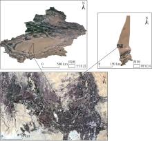
图1
于田绿洲研究区概况 注:基于新疆维吾尔自治区自然资源厅标准地图服务网站审图号为新S(2021)047号的标准地图制作,底图边界无修改。下同。"
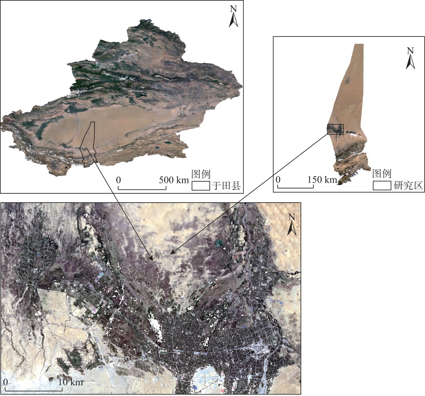
表1
Landsat数据热红外波段的定标参数"
| 定标参数 | Landsat5 | Landsat7 | Landsat8 |
|---|---|---|---|
| K1 | 607.76 | 666.09 | 774.8853 |
| K2 | 1260.56 | 1282.71 | 1321.0789 |

图2
技术路线"
表2
生态因子指数在第一主成分(PC1)的贡献率"
| 年份 | SAVI | WET | NDBSI | LST | DI | 特征值 | 贡献率/% |
|---|---|---|---|---|---|---|---|
| 2004 | 0.414 | 0.451 | -0.428 | -0.475 | -0.466 | 0.456 | 94.61 |
| 2005 | 0.459 | 0.444 | -0.432 | -0.440 | -0.461 | 0.481 | 93.76 |
| 2006 | 0.434 | 0.447 | -0.445 | -0.473 | -0.437 | 0.520 | 93.25 |
| 2007 | 0.446 | 0.446 | -0.428 | -0.468 | -0.447 | 0.481 | 94.19 |
| 2008 | 0.444 | 0.441 | -0.427 | -0.477 | -0.445 | 0.491 | 94.32 |
| 2009 | 0.445 | 0.443 | -0.438 | -0.462 | -0.447 | 0.498 | 94.75 |
| 2010 | 0.453 | 0.437 | -0.424 | -0.466 | -0.455 | 0.501 | 93.39 |
| 2011 | 0.442 | 0.460 | -0.427 | -0.463 | -0.443 | 0.525 | 94.58 |
| 2012 | 0.456 | 0.439 | -0.415 | -0.467 | -0.457 | 0.483 | 93.98 |
| 2013 | 0.452 | 0.384 | -0.462 | -0.479 | -0.454 | 0.479 | 91.26 |
| 2014 | 0.447 | 0.454 | -0.431 | -0.455 | -0.448 | 0.487 | 94.97 |
| 2015 | 0.440 | 0.441 | -0.428 | -0.483 | -0.442 | 0.489 | 94.48 |
| 2016 | 0.450 | 0.445 | -0.452 | -0.439 | -0.451 | 0.445 | 93.48 |
| 2017 | 0.440 | 0.437 | -0.431 | -0.484 | -0.442 | 0.440 | 93.52 |
| 2018 | 0.441 | 0.443 | -0.436 | -0.473 | -0.442 | 0.486 | 95.58 |
| 2019 | 0.433 | 0.446 | -0.431 | -0.484 | -0.441 | 0.439 | 92.92 |
| 2020 | 0.422 | 0.468 | -0.400 | -0.434 | -0.505 | 0.383 | 87.03 |
| 2021 | 0.411 | 0.442 | -0.442 | -0.484 | -0.453 | 0.459 | 92.39 |
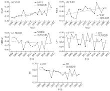
图3
2004—2021年于田绿洲生态因子时序变化趋势"
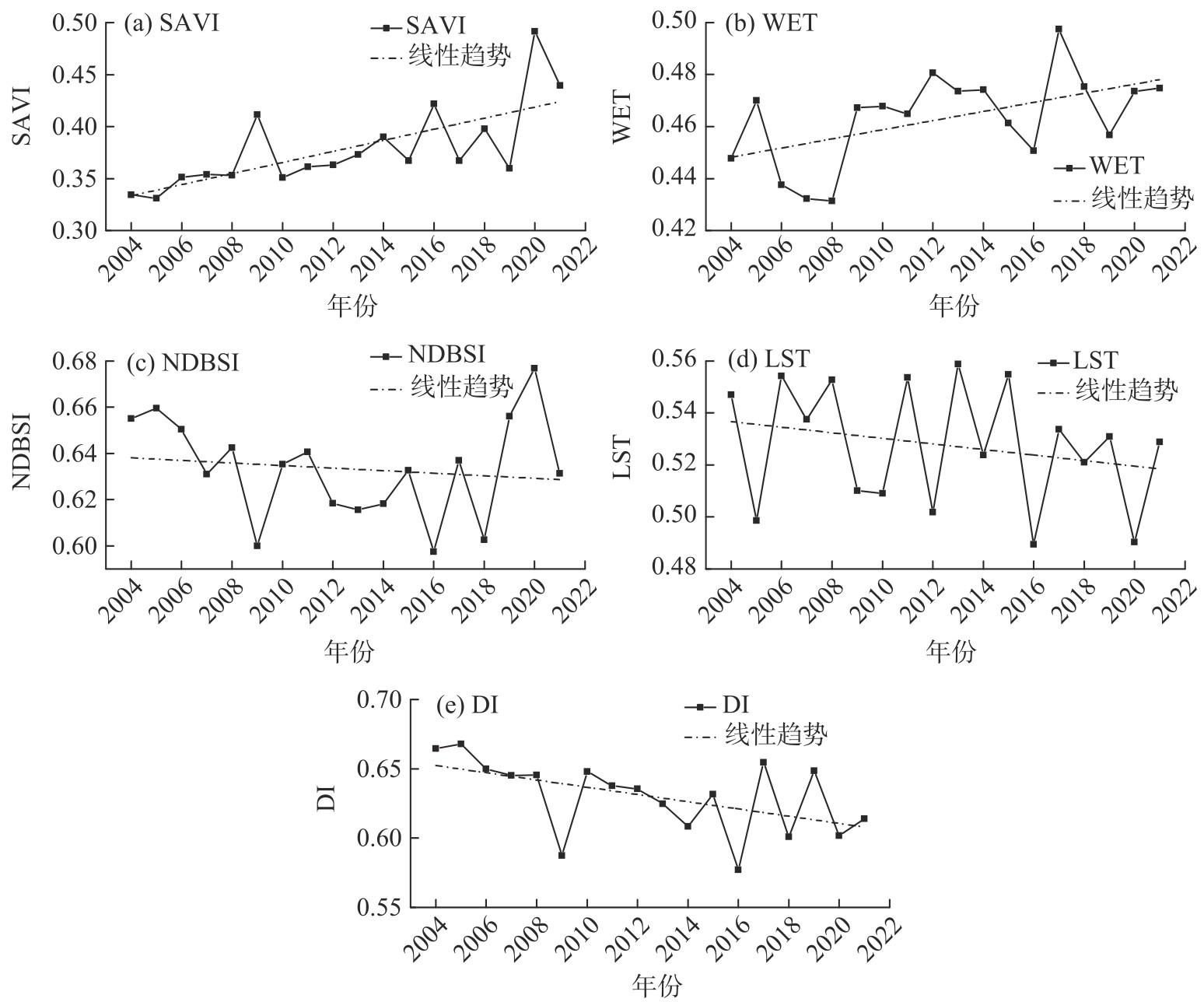

图4
2004—2021年于田县气候因子变化趋势"
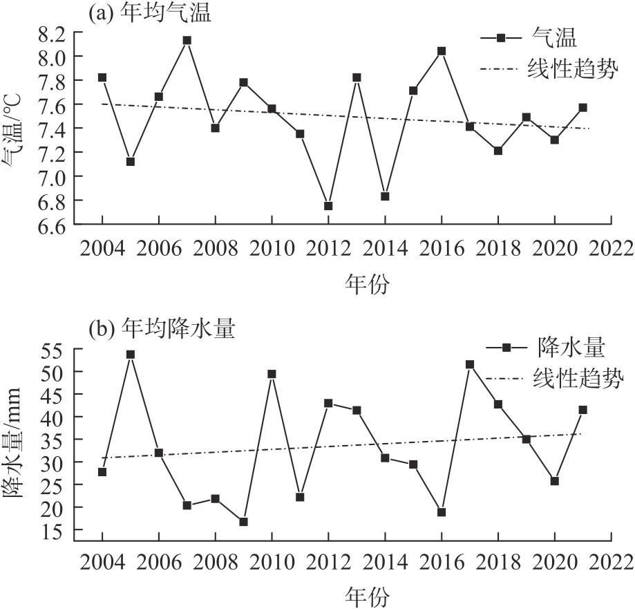
表3
DRSEI与生态因子的相关性"
| 因子 | DRSEI | SAVI | WET | NDBSI | LST | DI |
|---|---|---|---|---|---|---|
| DRSEI | 1.000 | 0.378 | 0.396 | -0.729 | -0.453 | -0.698 |
| SAVI | 0.378 | 1.000 | 0.307 | -0.117 | -0.481 | -0.801 |
| WET | 0.396 | 0.307 | 1.000 | -0.162 | -0.346 | -0.187 |
| NDBSI | -0.729 | -0.117 | -0.162 | 1.000 | 0.112 | 0.626 |
| LST | -0.453 | -0.481 | -0.346 | 0.112 | 1.000 | 0.431 |
| DI | -0.698 | -0.801 | -0.187 | 0.626 | 0.431 | 1.000 |
图5
2021年于田绿洲RSEI和DRSEI细节对比 注:RSEI为遥感生态指数;DRSEI为荒漠化遥感生态指数。下同。"
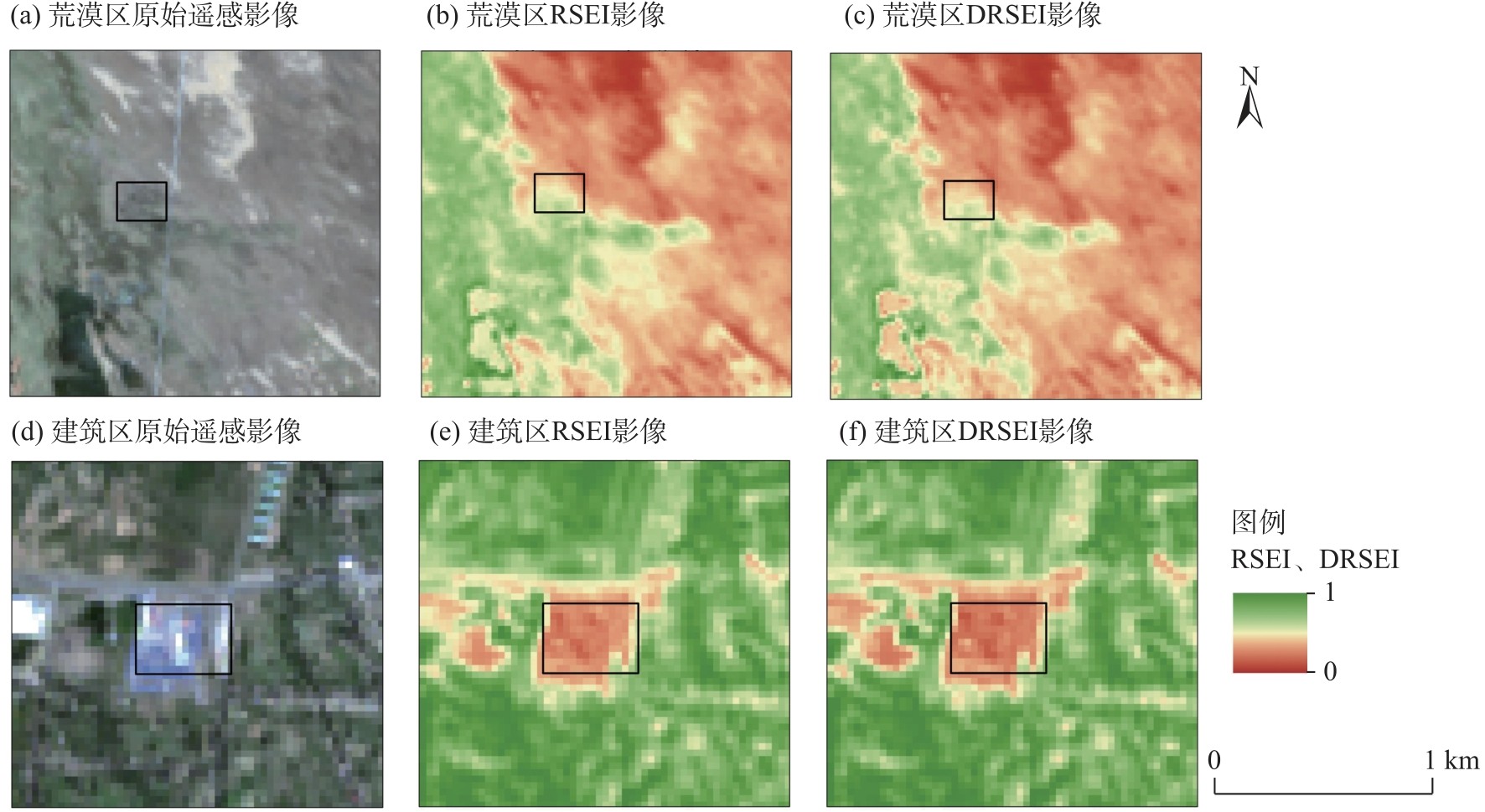
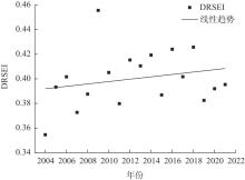
图6
2004—2021年于田绿洲DRSEI时序变化趋势"
图7
2004—2021年于田绿洲DRSEI空间分布"
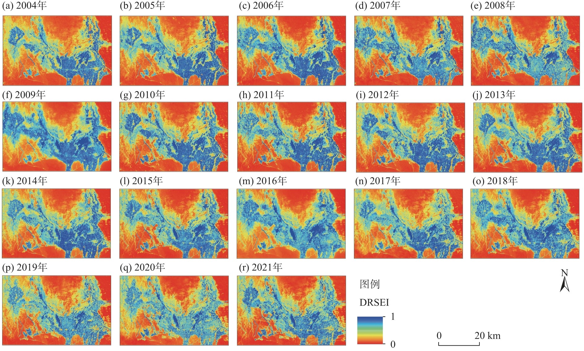
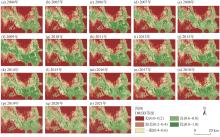
图8
2004—2021年于田绿洲DRSEI分级空间分布"
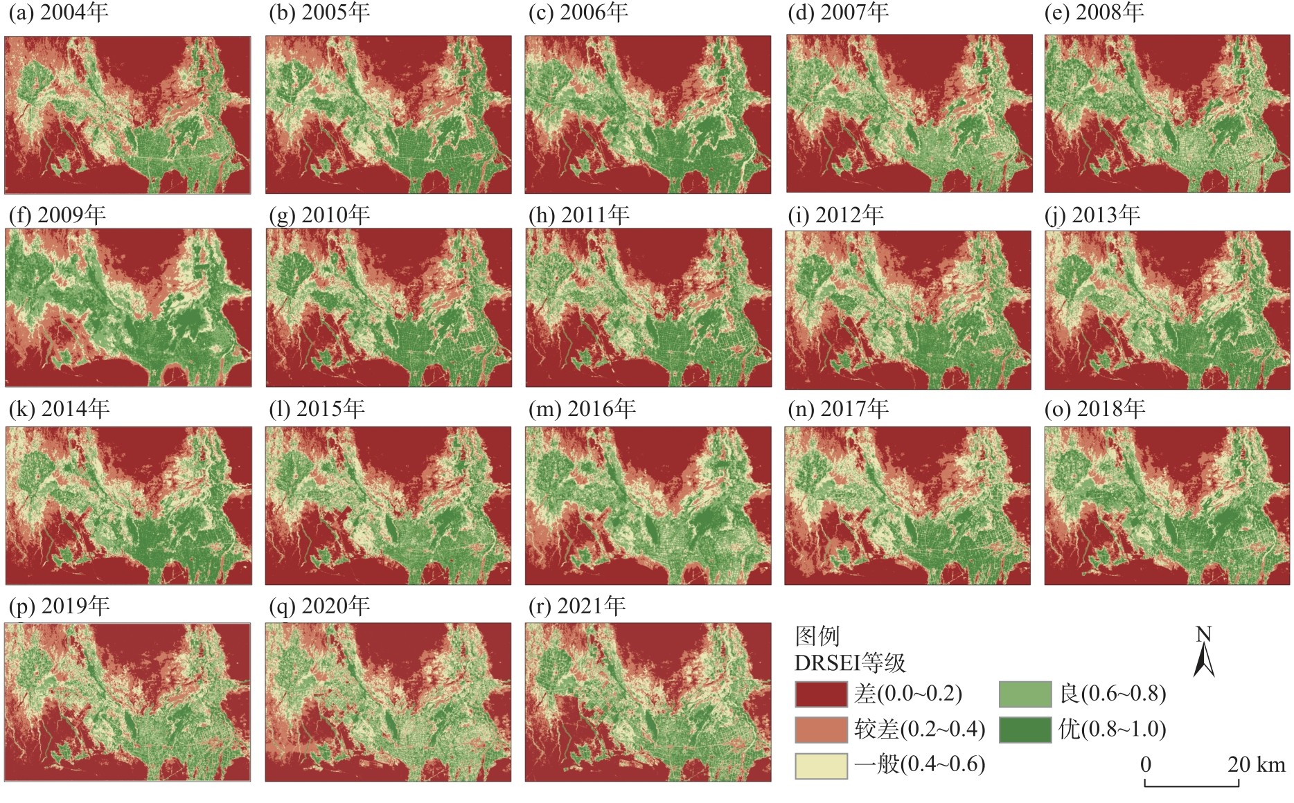
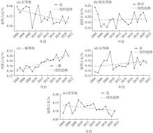
图9
2004—2021年于田绿洲DRSEI分级面积占比变化"
图10
2004—2021年于田绿洲DRSEI Sen趋势分析与变异系数"
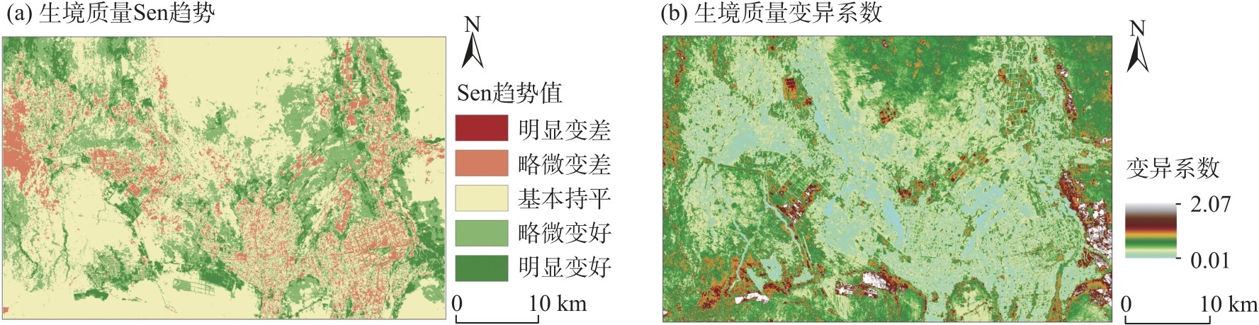
图11
2004—2021年于田绿洲Hurst指数未来趋势"
| [1] | 李红, 张迪, 雷宁. 推动生态环境系统保护修复促进人与自然和谐共生——以吉林省舒兰市为例[J]. 中国林业产业, 2023(3): 56-57. |
| [Li Hong, Zhang Di, Lei Ning. Promoting the protection and restoration of the ecological environment system, promoting the harmonious coexistence between man and nature: A case study of Shulan, Jilin Province[J]. China Forestry Industry, 2023(3): 56-57.] | |
| [2] | 董战峰, 张哲予, 杜艳春, 等. “绿水青山就是金山银山”理念实践模式与路径探析[J]. 中国环境管理, 2020, 12(5): 11-17. |
| [Dong Zhanfeng, Zhang Zheyu, Du Yanchun, et al. Practice mode and path of “lucid waters and lush mountains are invaluable assets”[J]. Chinese Journal of Environmental Management, 2020, 12(5): 11-17.] | |
| [3] | 林墨飞, 关雅文, 连艺霏. 基于“山水林田湖草沙”一体化保护治理的生态旅游景区规划设计研究——以章古台沙地国家森林公园为例[J]. 美与时代(上), 2024(4): 98-103. |
| [Lin Mofei, Guan Yawen, Lian Yifei. A study on the planning and design of eco-tourism scenic spots based on the integrated protection and management of mountains, rivers, forests, lakes, grass and sand: Taking Zhanggutai National Forest Park as an example[J]. Designs(I), 2024(4): 98-103.] | |
| [4] | 姜雨萌, 孙鹏. “绿水青山”如何转化为“绿色”的“金山银山”?——基于生态承载力对环境污染影响的传导机制研究[J]. 林业经济, 2020, 42(7): 15-26. |
| [Jiang Yumeng, Sun Peng. How to transform “lucid waters and lush mountains” to “mountains of gold and silver” with less pollution?: Study on the transmission mechanism of environmental pollution based on ecological carrying capacity[J]. Forestry Economics, 2020, 42(7): 15-26.] | |
| [5] | 张利民, 刘希刚. 山水林田湖草沙一体化保护的系统性逻辑[J]. 南京工业大学学报(社会科学版), 2024, 23(1): 24-32, 113. |
| [Zhang Limin, Liu Xigang. Systematic logic of integrated protection of landscape, forest, field, lake, grass and sand[J]. Journal of Nanjing Tech University (Social Sciences Edition), 2024, 23(1): 24-32, 113.] | |
| [6] | 郜国明, 田世民, 曹永涛, 等. 黄河流域生态保护问题与对策探讨[J]. 人民黄河, 2020, 42(9): 112-116. |
| [Gao Guoming, Tian Shimin, Cao Yongtao, et al. Discussion on the issues and countermeasures of ecological conservation of the Yellow River Basin[J]. Yellow River, 2020, 42(9): 112-116.] | |
| [7] | 陈春波, 李刚勇, 彭建. 1981—2018年新疆草地归一化植被指数时空特征及其对气候变化的响应[J]. 生态学报, 2023, 43(4): 1537-1552. |
| [Chen Chunbo, Li Gangyong, Peng Jian. Spatio-temporal characteristics of Xinjiang grassland NDVI and its response to climate change from 1981 to 2018[J]. Acta Ecologica Sinica, 2023, 43(4): 1537-1552.] | |
| [8] | Liu Y, Chai C, Zhang Q, et al. Monitoring and evaluation of ecological environment quality in the Tianshan Mountains of China using remote sensing from 2001 to 2020[J]. Sustainability, 2025, 17(4): 1673-1673. |
| [9] | Gupta K, Kumar P, Pathan S K, et al. Urban neighborhood green index: A measure of green spaces in urban areas[J]. Landscape and Urban Planning, 2012, 105(3): 325-335. |
| [10] | Yuan F, Bauer M E. Comparison of impervious surface area and normalized difference vegetation index as indicators of surface urban heat island effects in Landsat imagery[J]. Remote Sensing of Environment, 2007, 106(3): 375-386. |
| [11] | Nichol J. Remote sensing of uban heat islands by day and night[J]. Photogrammetric Enginering and Remote Sensing, 2005, 71(5): 613-621. |
| [12] | 徐涵秋. 区域生态环境变化的遥感评价指数[J]. 中国环境科学, 2013, 33(5): 889-897. |
| [Xu Hanqiu. A remote sensing index for assessment of regional ecological changes[J]. China Environmental Science, 2013, 33(5): 889-897.] | |
| [13] | 魏雨涵, 钱建平, 范伟伟, 等. 基于RSEI的漓江流域生态环境质量动态监测[J]. 中国水土保持科学, 2021, 19(1): 122-131. |
| [Wei Yuhan, Qian Jianping, Fan Weiwei, et al. Dynamic monitoring of ecological environment quality in Lijiang River Basin based on RSEI[J]. Science of Soil and Water Conservation, 2021, 19(1): 122-131.] | |
| [14] | 代云豪, 管瑶, 刘孟琴, 等. 1990—2020年阿拉尔垦区生态环境质量动态监测与评价[J]. 水土保持通报, 2022, 42(2): 122-128. |
| [Dai Yunhao, Guan Yao, Liu Mengqin, et al. Dynamic monitoring and evaluation of ecological environment quality in Alar reclamation area from 1990 to 2020[J]. Bulletin of Soil and Water Conservation, 2022, 42(2): 122-128.] | |
| [15] | Yang Z K, Tian J, Li W Y, et al. Spatio-temporal pattern and evolution trend of ecological environment quality in the Yellow River Basin[J]. Acta Ecologica Sinica, 2021, 41(19): 7627-7636. |
| [16] | 宝音涛格涛, 张永福. 基于遥感生态指数的渭库绿洲生态环境质量监测[J]. 中南农业科技, 2024, 45(1): 135-141. |
| [Bao Yintaogetao, Zhang Yongfu. Monitoring of ecological environment quality in the Weiku Oasis based on the remote sensing ecological index[J]. South-Central Agricultural Science and Technology, 2024, 45(1): 135-141.] | |
| [17] | 张乃明, 陈冬花, 邢菲, 等. 基于遥感生态指数的新疆干旱区博乐市生态变化分析[J]. 水土保持通报, 2019, 39(1): 154-159, 166. |
| [Zhang Naiming, Chen Donghua, Xing Fei, et al. Ecological change analysis of Bole City in arid regions of Xinjiang Wei Autonomous Region based on remote sensing ecological index[J]. Bulletin of Soil and Water Conservation, 2019, 39(1): 154-159, 166.] | |
| [18] |
蒋超亮, 吴玲, 刘丹, 等. 干旱荒漠区生态环境质量遥感动态监测——以古尔班通古特沙漠为例[J]. 应用生态学报, 2019, 30(3): 877-883.
doi: 10.13287/j.1001-9332.201903.008 |
|
[Jiang Chaoliang, Wu Ling, Liu Dan, et al. Dynamic monitoring of eco-environmental quality in arid desert area by remote sensing: Taking the Gurbantunggut Desert China as an example[J]. Chinese Journal of Applied Ecology, 2019, 30(3): 877-883.]
doi: 10.13287/j.1001-9332.201903.008 |
|
| [19] | 姜烨, 蒋玉祥. 干旱区绿洲城市生态变化遥感评价——以武威市凉州区为例[J]. 北京测绘, 2020, 34(5): 628-633. |
| [Jiang Ye, Jiang Yuxiang. Remote sensing evaluation of urban ecological changes in arid region oasis: Taking the Liangzhou District in Wuwei as an example[J]. Beijing Surveying and Mapping, 2020, 34(5): 628-633.] | |
| [20] | Zhang W B, Ma L B, Li H B, et al. Trends in the future evolution of rural settlements in oasis-desert areas under water use simulation scenarios: Take the Hexi Corridor region of China as an example[J]. Landscape and Urban Planning, 2024, 248: 18, doi: 10.1016/j.landurbplan.2024.105110. |
| [21] | 满苏尔·沙比提, 玉苏甫·买买提, 娜斯曼·那斯尔丁. 1991—2011年新疆于田绿洲土地利用/覆被时空变化特征分析[J]. 冰川冻土, 2014, 36(3): 582-589. |
| [Sabit Mansur, Mamat Yusuf, Nasirdin Nasima. Spatio-temporal characteristics analysis of land use/cover changes in Yutian Oasis, Xinjiang during 1991—2011[J]. Journal of Glaciology and Geocryology, 2014, 36(3): 582-589.] | |
| [22] | 许发号. 丝绸之路上的冰雪奇葩──新疆于田县供销社改革侧记[J]. 中国供销合作经济, 2001(2): 67, 70. |
| [Xu Fahao. A rare flower on the Silk Road: A sidelights on the reform of the Xinjiang Yutian County supply and marketing association[J]. China Co-operation Economy, 2001(2): 67, 70.] | |
| [23] | 江红南. 干旱区绿洲土壤湿度时空变化影响因素及其影响力分析[J]. 江苏农业科学, 2018, 46(20): 286-291. |
| [Jiang Hongnan. Analysis of influence factors and their influences of temporal and spatial changes of soil moisture in oasis of arid areas[J]. Jiangsu Agricultural Sciences, 2018, 46(20): 286-291.] | |
| [24] | 古丽娜尔·哈里别克. 于田绿洲土壤盐分对芦苇生长的影响研究[D]. 乌鲁木齐: 新疆大学, 2012. |
| [Halibak Gulnar. The soil salinity effects on the growth of Phragmites australis in Yutian Oasis[D]. Urumqi: Xinjiang University, 2012.] | |
| [25] | 依力亚斯江·努尔麦麦提, 师庆东, 阿不都拉·阿不力孜, 等. 灰色评估模型定量评价于田绿洲土壤盐渍化风险[J]. 农业工程学报, 2019, 35(8): 176-184. |
| [Nurmemet Ilyas, Shi Qingdong, Abliz Abdulla, et al. Quantitative evaluation of soil salinization risk in Keriya Oasis based on grey evaluation model[J]. Transactions of the Chinese Society of Agricultural Engineering, 2019, 35(8): 176-184.] | |
| [26] | An M, Meng F, He W J, et al. Assessment on eco-environmental quality of the Yellow River Basin by considering desertification index[J]. Journal of Mountain Science, 2024, 21: 3275-3292. |
| [27] | Huete A R. A soil-adjusted vegetation index (SAVI)[J]. Remote Sensing of Environment, 1988, 25(3): 295-309.] |
| [28] | 曾丽红, 宋开山, 张柏, 等. 应用Landsat数据和SEBAL模型反演区域蒸散发及其参数估算[J]. 遥感技术与应用, 2008, 23(3): 255-263. |
| [Zeng Lihong, Song Kaishan, Zhang Bo, et al. Applying Landsat data and SEBAL model to inverse regional evapotranspiration and its parameters estimation[J]. Remote Sensing Technology and Application, 2008, 23(3): 255-263.] | |
| [29] | van de Griend A, Owe M. On the relationship between thermal emissivity and the normalized difference vegetation index for natural surfaces[J]. International Journal of Remote Sensing, 1993, 14(6): 1119-1121. |
| [30] | 李博伦, 遆超普, 颜晓元. Landsat 8陆地成像仪影像的缨帽变换推导[J]. 测绘科学, 2016, 41(4): 102-107. |
| [Li Bolun, Di Chaopu, Yan Xiaoyuan. Study of derivation of tasseled cap transformation for Landsat 8 OLI images[J]. Science of Surveying and Mapping, 2016, 41(4): 102-107.] | |
| [31] | NASA. NASA's Web site:The Landsat-7 science data user's handbook[EB/OL]. [2024-04-19]. http://ltpwww.gsfc.nasa.gov/IAS/handbook/handbook.toc.html. |
| [32] | 李红军, 雷玉平, 郑力, 等. SEBAL模型及其在区域蒸散研究中的应用[J]. 遥感技术与应用, 2005, 20(3): 321-325. |
| [Li Hongjun, Lei Yuping, Zheng Li, et al. SEBAL model and its application in the study of regional evapotranspiration[J]. Remote Sensing Technology and Application, 2005, 20(3): 321-325.] | |
| [33] | Roy P S, Rikimaru A, Miyatake S. Tropical forest cover density mapping[J]. Tropical Ecology, 2002, 43(1): 39-47. |
| [34] | Xu H. A new index for delineating built-up land features in satellite imagery[J]. International Journal of Remote Sensing, 2008, 29(14): 4269-4276. |
| [35] | 蒋欣洪, 宋伟东, 孙尚宇. 改进型遥感生态指数在银川市生态环境质量评价中的应用[J]. 西北林学院学报, 2025, 40(3): 208-218. |
| [Jiang Xinhong, Song Weidong, Sun Shangyu. Application of improved remote sensing ecological index in ecological environment evaluation in Yinchuan City[J]. Journal of Northwest Forestry University, 2025, 40(3): 208-218.] | |
| [36] |
罗镕基, 王宏涛, 王成. 基于改进遥感生态指数的甘肃省古浪县生态质量评价[J]. 干旱区地理, 2023, 46(4): 539-549.
doi: 10.12118/j.issn.1000-6060.2022.322 |
|
[Luo Rongji, Wang Hongtao, Wang Cheng. Ecological quality evaluation of Gulang County in Gansu Province based on improved remote sensing ecological index[J]. Arid Land Geography, 2023, 46(4): 539-549.]
doi: 10.12118/j.issn.1000-6060.2022.322 |
|
| [37] |
徐涵秋, 邓文慧. MRSEI指数的合理性分析及其与RSEI指数的区别[J]. 遥感技术与应用, 2022, 37(1): 1-7.
doi: 10.11873/j.issn.1004-0323.2022.1.0001 |
| [Xu Hanqiu, Deng Wenhui. Rationality analysis of MRSEI and its difference with RSEI[J]. Remote Sensing Technology and Application, 2022, 37(1): 1-7.] | |
| [38] |
李新妹, 吴作航, 王震山, 等. 基于MODIS遥感数据的福建植被生产力时空分布与干旱响应分析[J]. 生态环境学报, 2024, 33(6): 841-852.
doi: 10.16258/j.cnki.1674-5906.2024.06.002 |
| [Li Xinmei, Wu Zuohang, Wang Zhenshan, et al. Spatio-temporal dynamics of vegetation productivity and drought impacts in Fujian Province using MODIS data[J]. Ecology and Environmental Sciences, 2024, 33(6): 841-852.] | |
| [39] | 薛桦, 刘萍. 基于RSEI的黄河中游地区生态环境质量时空演化特征及驱动因素——以延安市为例[J]. 水土保持研究, 2024, 31(1): 373-384. |
| [Xue Hua, Liu Ping. Spatiotemporal variation of ecological environmental quality and its response to different driving factors in the section of Yellow River Basin in recent 31 years: Taking Yan'an City as an example[J]. Research of Soil and Water Conservation, 2024, 31(1): 373-384.] | |
| [40] | 燕爱玲, 黄强, 王义民. 黄河流域径流演变的持久性测度[J]. 干旱区资源与环境, 2007, 21(11): 27-30. |
| [Yan Ailing, Huang Qiang, Wang Yimin. Persistence measure on runoff evolution of the Yellow River[J]. Journal of Arid Land Resources and Environment, 2007, 21(11): 27-30.] | |
| [41] | 易雪, 李得勤, 杨森, 等. 植被覆盖度增加对辽宁地区气温变化的影响研究[J]. 大气科学, 2024, 48(2): 463-479. |
| [Yi Xue, Li Deqin, Yang Sen, et al. Impact of fractional vegetation coverage increase on air temperature change in Liaoning Province[J]. Chinese Journal of Atmospheric Sciences, 2024, 48(2): 463-479.] | |
| [42] | 汤从沧, 李巧, 陶洪飞, 等. 基于改进遥感生态指数模型的塔里木河流域生态环境质量评价[J]. 环境科学, 2025, 46(7): 4485-4498. |
| [Tang Congcang, Li Qiao, Tao Hongfei, et al. Evaluation of the ecological environment quality in the Tarim River Basin based on the modified remote sensing ecological index model[J]. Environmental Science, 2025, 46(7): 4485-4498.] | |
| [43] |
胡瑞媛, 畅建霞, 郭爱军, 等. 塔里木河干流生态系统变化与生态效益分析[J]. 干旱区地理, 2024, 47(4): 622-633.
doi: 10.12118/j.issn.1000-6060.2023.254 |
|
[Hu Ruiyuan, Chang Jianxia, Guo Aijun, et al. Ecosystem variation and ecological benefits analysis of the mainstream of Tarim River[J]. Arid Land Geography, 2024, 47(4): 622-633.]
doi: 10.12118/j.issn.1000-6060.2023.254 |
|
| [44] | 国家林业和草原局. 新疆于田县“梯田式”治沙助力打好塔克拉玛干沙漠边缘阻击战[N]. 三北工程简报, 2024-07-09. |
| [National Forestry and Grassland Administration. The sand control approach in Yutian County, Xinjiang, contributes to the effective containment of the Taklimakan Desert's encroachment[N]. Three-North Project Briefing, 2024-07-09.] | |
| [45] | 国家环保总局. HJ/T192-2006. 中华人民共和国环境保护行业标准(试行)[S]. 北京: 中国环境科学出版社, 2006. |
| [Ministry of Environmental Protection of the People's Republic of China. HJ/T192-2006. Industry standard for environment in the People's Republic of China protection (trial)[S]. Beijing: China Environmental Science Press, 2006.] | |
| [46] |
柯丽娜, 徐佳慧, 王楠, 等. 基于遥感生态指数的滨海湿地生态质量变化评价——以辽东湾北部区为例[J]. 生态环境学报, 2022, 31(7): 1417-1424.
doi: 10.16258/j.cnki.1674-5906.2022.07.014 |
| [Ke Li'na, Xu Jiahui, Wang Nan, et al. Evaluation of ecological quality of coastal wetland based on remote sensing ecological index: A case study of northern Liaodong Bay[J]. Ecology and Environmental Sciences, 2022, 31(7): 1417-1424.] | |
| [47] |
王丽霞, 赵蕊, 刘招, 等. 基于RSEI的延河流域生态环境质量监测与预估[J]. 干旱区研究, 2022, 39(3): 943-954.
doi: 10.13866/j.azr.2022.03.28 |
|
[Wang Lixia, Zhao Rui, Liu Zhao, et al. Monitoring and prediction of ecological environmental quality in the Yanhe River Basin based on the remote sensing ecological index[J]. Arid Zone Research, 2022, 39(3): 943-954.]
doi: 10.13866/j.azr.2022.03.28 |
|
| [48] | 赵学鹏, 王媛媛. 绿洲乡村聚落分布特征及其驱动机制——基于新疆于田县的分析[J]. 乡村论丛, 2021(3): 95-101. |
| [Zhao Xuepeng, Wang Yuanyuan. Distribution characteristics and driving mechanism of oasis rural settlements: An analysis based on Yutian County, Xinjiang[J]. The Village, 2021(3): 95-101.] | |
| [49] | 古丽米热·艾米肉拉, 艾合麦提·吾买尔, 海米提·依米提. 于田绿洲近50年人类活动强度变化研究[J]. 西南农业大学学报(社会科学版), 2011, 9(10): 40-42. |
| [Amiroula Gulmira, Wumar Ehmat, Emmit Hamit. Study on the change of human activity intensity in Yutian Oasis in recent 50 years[J]. Journal of Teacher Education, 2011, 9(10): 40-42.] | |
| [50] | 杜梦迪, 李兰, 罗光明, 等. 气候与土地利用变化对于田绿洲农业耗水特征的影响[J]. 水土保持通报, 2020, 40(3): 103-109. |
| [Du Mengdi, Li Lan, Luo Guangming, et al. Effects of climate and land use change on agricultural water consumption in Yutian Oasis[J]. Bulletin of Soil and Water Conservation, 2020, 40(3): 103-109.] | |
| [51] | 陈春波, 李刚勇. 1981—2020年昆仑山-阿尔金山草地NDVI时空变化及其对气温、降水的响应[J]. 中国草地学报, 2023, 45(2): 13-25. |
| [Chen Chunbo, Li Gangyong. Temporal and spatial variation of grassland NDVl in Kunlun Mountains, Altun Mountains and its responses to temperature and precipitation from 1981 through 2020[J]. Chinese Journal of Grassland, 2023, 45(2): 13-25.] | |
| [52] | 姚一平, 瓦哈甫·哈力克, 伏吉芮. 西北干旱区绿洲沙漠化与盐渍化驱动力分析——以于田绿洲为例[J]. 黑龙江大学自然科学学报, 2015, 32(4): 519-525. |
| [Yao Yiping, Halek Wahhaf, Fu Jirui. Analysis on the driving forces of oasis desertification and salinization in the arid region of northwest China: A case study of Keriya Oasis[J]. Journal of Natural Science of Heilongjiang University, 2015, 32(4): 519-525.] | |
| [53] | 艾合买提·吾买尔, 海米提·依米提, 赛迪古丽·哈西木, 等. 于田绿洲脆弱生态环境成因及生态脆弱性评价[J]. 干旱区资源与环境, 2010, 24(5): 74-79. |
| [Wumar Ehmat, Emmit Hamit, Kasim Sadigul, et al. Formation and assessment of eco-environmental fragility of Yutian Oasis[J]. Journal of Arid Land Resources and Environment, 2010, 24(5): 74-79.] | |
| [54] | 刘传胜. 基于3S技术的绿洲-荒漠过渡带生态环境变化预警线的提取研究[D]. 乌鲁木齐: 新疆大学, 2002. |
| [Liu Chuansheng. Extracting precaution line of the oasis-desert transition belt based on“3S” techniques[D]. Urumqi: Xinjiang University, 2002.] | |
| [55] | 张伟, 杜培军, 郭山川, 等. 改进型遥感生态指数及干旱区生态环境评价[J]. 遥感学报, 2023, 27(2): 299-317. |
| [Zhang Wei, Du Peijun, Guo Shanchuan, et al. Enhanced remote sensing ecological index and ecological environment evaluation in arid area[J]. National Remote Sensing Bulletin, 2023, 27(2): 299-317.] |
| [1] | 张晓明, 宿星, 张军, 贾静. 基于PLUS-InVEST模型的甘肃通渭滑坡区生境质量时空变化及预测[J]. 干旱区地理, 2025, 48(7): 1220-1232. |
| [2] | 闫晓梅, 王宏卫, 罗魁, 董康宁, 郭瑞杰, 郑旭东. 基于生态安全格局确定县域生物多样性保护的优先区域——以布尔津县为例[J]. 干旱区地理, 2025, 48(4): 586-598. |
| [3] | 李红阳, 陈天宇, 王圣杰, 张明军. 1979—2021年新疆昆仑山北坡潜在蒸散时空变化研究[J]. 干旱区地理, 2024, 47(9): 1443-1450. |
| [4] | 康立民, 滕心如, 车佳航, 怀保娟. 昆仑山北坡区域积雪时空变化特征[J]. 干旱区地理, 2024, 47(9): 1462-1471. |
| [5] | 夏婷婷, 薛璇, 王灏伟, 徐文哲, 盛紫怡, 汪洋. 昆仑山北坡陆地水储量变化及其驱动因素分析[J]. 干旱区地理, 2024, 47(8): 1292-1303. |
| [6] | 张璐, 孙美平, 闫欣, 王伟生, 范蕊谊. 基于多源数据的昆仑山北坡地表太阳辐射调查评估[J]. 干旱区地理, 2024, 47(8): 1304-1313. |
| [7] | 张晓东, 武丹, 王莹, 赵银鑫, 马瑜, 马玉学, 倪海玲. 耦合InVEST与Geodetector模型的银川市生境质量时空演变特征及影响因子研究[J]. 干旱区地理, 2024, 47(7): 1242-1251. |
| [8] | 石玉东, 王圣杰, 张明军, 朱成刚, 车彦军. 昆仑山北坡地表水氢氧稳定同位素空间分布特征[J]. 干旱区地理, 2024, 47(7): 1127-1135. |
| [9] | 周洪华, 杨玉海, 朱成刚, 方功焕. 供需平衡视角下昆仑山北坡县域单元地表水资源开发利用潜力初探[J]. 干旱区地理, 2024, 47(7): 1106-1115. |
| [10] | 朱成刚, 陈亚宁, 张明军, 车彦军, 孙美平, 赵锐锋, 汪洋, 刘玉婷. 昆仑山北坡水资源科学考察初报[J]. 干旱区地理, 2024, 47(7): 1097-1105. |
| [11] | 陈亚宁, 朱成刚, 李稚, 方功焕. 昆仑山北坡区域高质量发展面临的问题、机遇与挑战[J]. 干旱区地理, 2024, 47(5): 733-740. |
| [12] | 安文举, 鱼亦凡, 郝姗姗, 王英弟, 李小兵, 麦旭东. 基于土地利用变化的陕北多沙粗沙区生境质量演变及响应分析[J]. 干旱区地理, 2024, 47(3): 474-484. |
| [13] | 刘玉婷, 陈亚宁, 朱成刚, 张淑花, 黄心垚. 2003—2022年昆仑山北坡典型湖泊水位变化及其归因[J]. 干旱区地理, 2024, 47(11): 1805-1815. |
| [14] | 仇泽炜, 方功焕, 陈亚宁, 朱成刚, 梁文婷, 邸彦峰, 吕浩东. 昆仑山北坡高山流域洪水变化特征[J]. 干旱区地理, 2024, 47(11): 1816-1827. |
| [15] | 陈满, 陈亚宁, 方功焕, 李玉朋, 孙慧兰. 昆仑山北坡冰川湖变化及其溃决风险评估[J]. 干旱区地理, 2024, 47(10): 1628-1639. |
|
||