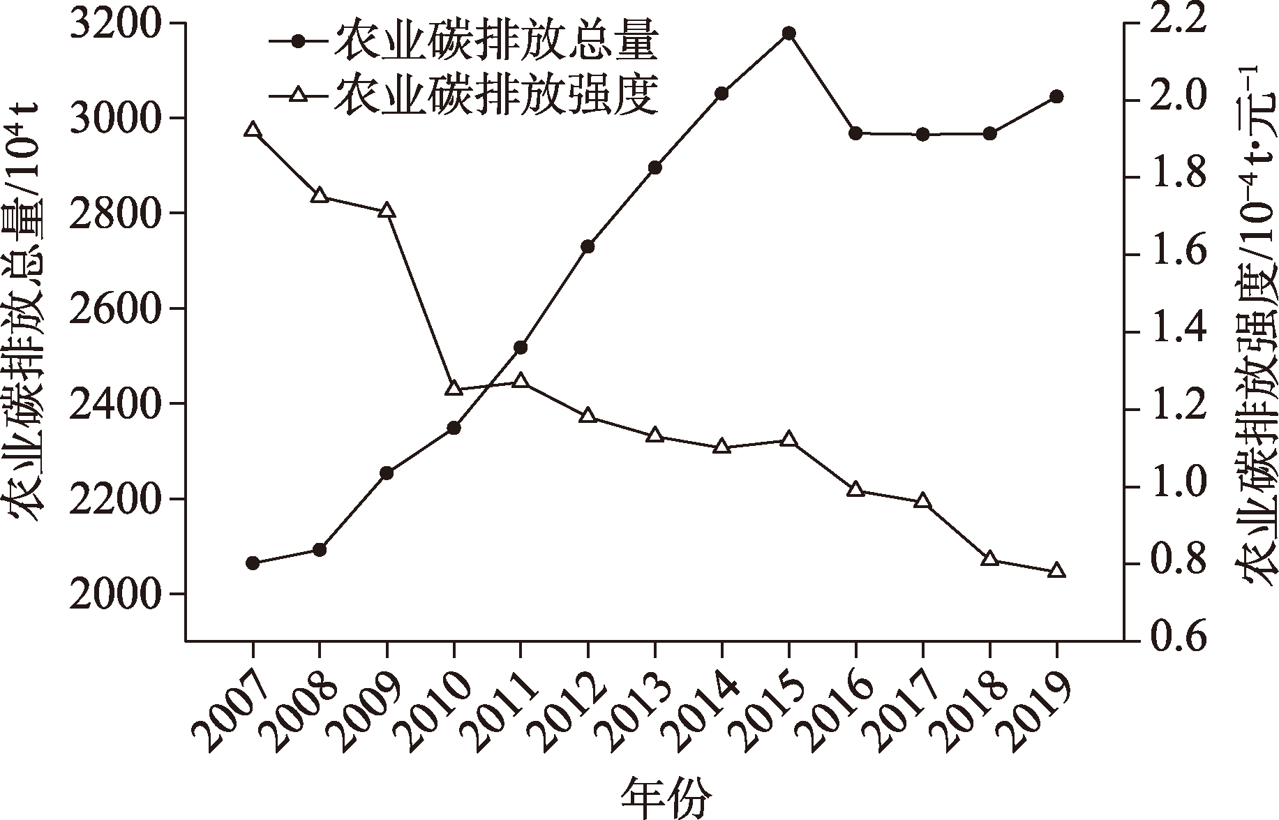
| [1] |
BP. BP Statistical Review of World Energy 2022[R/OL]. [2022-11-20]. https://www.bp.com/content/dam/bp/business-sites/en/glo-bal/corporate-/pdfs/energy-economics/statistical-review/bp-stats-review-2021-full-report.pdf.
|
| [2] |
赵文晋, 李都峰, 王宪恩. 低碳农业的发展思路[J]. 环境保护, 2010(12): 38-39.
|
|
[Zhao Wenjin, Li Dufeng, Wang Xian’en. Development ideas of low-carbon agriculture[J]. Environmental Protection, 2010(12): 38-39.]
|
| [3] |
田云, 尹忞昊. 中国农业碳排放再测算: 基本现状、动态演进及空间溢出效应[J]. 中国农村经济, 2022(3): 104-127.
|
|
[Tian Yun, Yin Minhao. Re-evaluation of China’s agricultural carbon emissions: Basic status, dynamic evolution and spatial spillover effects[J]. Chinese Rural Economy, 2022(3): 104-127.]
|
| [4] |
冉锦成, 马惠兰, 苏洋. 西北五省农业碳排放测算及碳减排潜力研究[J]. 江西农业大学学报, 2017, 39(3): 623-632.
|
|
[Ran Jincheng, Ma Huilan, Su Yang. A study on agricultural carbon emission and carbon emission reduction potential in five provinces in northwest China[J]. Acta Agriculturae Universitatis Jiangxiensis, 2017, 39(3): 623-632.]
|
| [5] |
刘华军, 鲍振, 杨骞. 中国农业碳排放的地区差距及其分布动态演进——基于Dagum基尼系数分解与非参数估计方法的实证研究[J]. 农业技术经济, 2013(3): 72-81.
|
|
[Liu Huajun, Bao Zhen, Yang Qian. The regional gap of China’s agricultural carbon emissions and its distribution dynamic evolution: An empirical study based on Dagum Gini coefficient decomposition and nonparametric estimation method[J]. Journal of Agrotechnical Economics, 2013(3): 72-81.]
|
| [6] |
张恒硕, 李绍萍, 彭民. 中国农村能源消费碳排放区域非均衡性及驱动因素动态识别[J]. 中国农村经济, 2022(1): 112-134.
|
|
[Zhang Hengshuo, Li Shaoping, Peng Min. Regional imbalance of carbon emissions from China’s rural energy consumption and dynamic identification of driving factors[J]. Chinese Rural Economy, 2022(1): 112-134.]
|
| [7] |
周嘉, 王钰萱, 刘学荣, 等. 基于土地利用变化的中国省域碳排放时空差异及碳补偿研究[J]. 地理科学, 2019, 39(12): 1955-1961.
doi: 10.13249/j.cnki.sgs.2019.12.014
|
|
[Zhou Jia, Wang Yuxuan, Liu Xuerong, et al. Spatial temporal differences of carbon emissions and carbon compensation in China based on land use change[J]. Scientia Geographica Sinica, 2019, 39(12): 1955-1961.]
doi: 10.13249/j.cnki.sgs.2019.12.014
|
| [8] |
Rathna H, Phanna L, Putra A S, et al. Estimation of carbon dioxide emissions from a traditional nutrient-rich Cambodian diet food production system using life cycle assessment[J]. Sustainability, 2021, 13(7): 3660, doi: 10.3390/su13073660.
doi: 10.3390/su13073660
|
| [9] |
Zhang L, Ruiz-Menjivar J, Tong Q, et al. Examining the carbon footprint of rice production and consumption in Hubei, China: A life cycle assessment and uncertainty analysis approach[J]. Journal of Environmental Management, 2021, 300: 113698, doi: 10.1016/j.jenvman.2021.113698.
doi: 10.1016/j.jenvman.2021.113698
|
| [10] |
李波, 张俊飚, 李海鹏. 中国农业碳排放时空特征及影响因素分解[J]. 中国人口·资源与环境, 2011, 21(8): 80-86.
|
|
[Li Bo, Zhang Junbiao, Li Haipeng. Research on spatial-temporal characteristics and affecting factors decomposition of agricultural carbon emission in China[J]. China Population, Resources and Environment, 2011, 21(8): 80-86.]
|
| [11] |
田云, 张俊飚, 尹朝静, 等. 中国农业碳排放分布动态与趋势演进——基于31个省(市、区)2002—2011年的面板数据分析[J]. 中国人口·资源与环境, 2014, 24(7): 91-98.
|
|
[Tian Yun, Zhang Junbiao, Yin Zhaojing, et al. Distributional dynamics and trend evolution of China’s agricultural carbon emissions: An analysis on panel data of 31 provinces from 2002 to 2011[J]. China Population, Resources and Environment, 2014, 24(7): 91-98.]
|
| [12] |
龙志, 孙颖琦, 郎丽霞, 等. 黄土高原典型县域碳排放特征与时空格局——以庆城县为例[J]. 干旱区研究, 2022, 39(5): 1631-1641.
|
|
[Long Zhi, Sun Yingqi, Lang Lixia, et al. Spatiotemporal patterns and characteristics of carbon emissions in the Loess Plateau: A case study of Qingcheng County[J]. Arid Zone Research, 2022, 39(5): 1631-1641.]
|
| [13] |
高鸣, 宋洪远. 中国农业碳排放绩效的空间收敛与分异——基于Malmquist-luenberger指数与空间计量的实证分析[J]. 经济地理, 2015, 35(4): 142-148, 185.
|
|
[Gao Ming, Song Hongyuan. Dynamic changes and spatial agglomeration analysis of the Chinese agricultural carbon emissions performance[J]. Economic Geography, 2015, 35(4): 142-148, 185.]
|
| [14] |
Li N, Li Y M, Mu H L, et al. Convergence of China’s agricultural greenhouse gases[J]. Applied Ecology and Environmental Research, 2020, 18(1): 609-624.
doi: 10.15666/aeer
|
| [15] |
Cui Y, Khan S U, Deng Y, et al. Spatiotemporal heterogeneity, convergence and its impact factors: Perspective of carbon emission intensity and carbon emission per capita considering carbon sink effect[J]. Environmental Impact Assessment Review, 2022, 92: 106699, doi: 10.1016/j.eiar.2021.106699.
doi: 10.1016/j.eiar.2021.106699
|
| [16] |
IPCC. Climate change 2007:Mitigation of climate change. Contribution of working group Ⅲ to the fourth assessment report of the intergovernmental panel on climate change[R]. Cambridge: Cambridge University Press, 2007: 63-67.
|
| [17] |
段华平, 张悦, 赵建波, 等. 中国农田生态系统的碳足迹分析[J]. 水土保持学报, 2011, 25(5): 203-208.
|
|
[Duan Huaping, Zhang Yue, Zhao Jianbo, et al. Carbon footprint analysis of farmland ecosystem in China[J]. Journal of Soil and Water Conservation, 2011, 25(5): 203-208.]
|
| [18] |
杨乐, 邓辉, 李国学, 等. 新疆绿洲区秸秆燃烧污染物释放量及固碳减排潜力[J]. 农业环境科学学报, 2015, 34(5): 988-993.
|
|
[Yang Le, Deng Hui, Li Guoxue, et al. Pollutant releases from crop residue burning and carbon emission mitigation potential by biochar in Xinjiang oasis[J]. Journal of Agro-Environment Science, 2015, 34(5): 988-993.]
|
| [19] |
闵继胜, 胡浩. 中国农业生产温室气体排放量的测算[J]. 中国人口·资源与环境, 2012, 22(7): 21-27.
|
|
[Min Jisheng, Hu Hao. Calculation of greenhouse gases emission from agricultural production in China[J]. China Population, Resources and Environment, 2012, 22(7): 21-27.]
|
| [20] |
胡向东, 王济民. 中国畜禽温室气体排放量估算[J]. 农业工程学报, 2010, 26(10): 247-252.
|
|
[Hu Xiangdong, Wang Jimin. Estimation of livestock greenhouse gases discharge in China[J]. Transactions of the Chinese Society of Agricultural Engineering, 2010, 26(10): 247-252.]
|
| [21] |
毕于运, 高春雨, 王亚静, 等. 中国秸秆资源数量估算[J]. 农业工程学报, 2009, 25(12): 211-217.
|
|
[Bi Yuyun, Gao Chunyu, Wang Yajing, et al. Estimation of straw resources in China[J]. Transactions of the Chinese Society of Agricultural Engineering, 2009, 25(12): 211-217.]
|
| [22] |
杨骞, 司祥慧, 王珏. 减排增汇目标下中国粮食生产效率的测度及分布动态演进[J]. 自然资源学报, 2022, 37(3): 600-615.
doi: 10.31497/zrzyxb.20220304
|
|
[Yang Qian, Si Xianghui, Wang Jue. The measurement and its distribution dynamic evolution of grain production efficiency in China under the goal of reducing pollution emissions and increasing carbon sink[J]. Journal of Natural Resources, 2022, 37(3): 600-615.]
doi: 10.31497/zrzyxb.20220304
|
| [23] |
姜磊, 柏玲. 中国能源强度的空间分布与收敛研究——基于动态空间面板模型的分析[J]. 西部论坛, 2014, 24(4): 61-69.
|
|
[Jiang Lei, Bo Ling. Study on spatial distribution and convergence of China’s energy intensity: Analysis based on dynamic spatial panel model[J]. Western Forum, 2014, 24(4): 61-69.]
|
| [24] |
Tobler W R. A computer movie simulating urban growth in the Detroit region[J]. Economic Geography, 1970, 46: 234, doi: 10.2307/143141.
doi: 10.2307/143141
|
| [25] |
王钰凯, 郭辉. 新疆旅游业生态效率时空分异与收敛性研究[J]. 干旱区地理, 2022, 45(4): 1320-1331.
|
|
[Wang Yukai, Guo Hui. Spatial and temporal differentiation and convergence studies of the eco-efficiency of Xinjiang tourism industry[J]. Arid Land Geography, 2022, 45(4): 1320-1331.]
|
| [26] |
桂河, 李静, 尚梦媛. “双碳”背景下的宁夏农业碳排放时序特征、驱动机理与脱钩效应研究[J]. 中南林业科技大学学报(社会科学版), 2021, 15(6): 37-44.
|
|
[Gui He, Li Jing, Shang Mengyuan. Study on temporal characteristics, driving mechanism and decoupling effect of agricultural carbon emission in Ningxia under the background of “double carbon”[J]. Journal of Central South University of Forestry & Technology (Social Sciences Edition), 2021, 15(6): 37-44.]
|
| [27] |
夏文浩, 潘生亮, 霍瑜, 等. 新疆农业面源污染的时空分异及动态演进——基于特色畜牧视角的再分析[J]. 资源开发与市场, 2022, 38(10): 1190-1199.
|
|
[Xia Wenhao, Pan Shengliang, Huo Yu, et al. Spatial-temporal differentiation and dynamic evolution of agricultural non-point source pollution in Xinjiang: Re-analysis based on the perspective of characteristic animal husbandry[J]. Resource Development & Market, 2022, 38(10): 1190-1199.]
|
| [28] |
罗斯炫, 何可, 张俊飚. 增产加剧污染?——基于粮食主产区政策的经验研究[J]. 中国农村经济, 2020(1): 108-131.
|
|
[Luo Sixuan, He Ke, Zhang Junbiao. The more grain production, the more fertilizers pollution: Empirical evidence from major grain-producing areas in China[J]. Chinese Rural Economy, 2020(1): 108-131.]
|
| [29] |
冉锦成, 苏洋, 胡金凤, 等. 新疆农业碳排放时空特征、峰值预测及影响因素研究[J]. 中国农业资源与区划, 2017, 38(8): 16-24.
|
|
[Ran Jincheng, Su Yang, Hu Jinfeng, et al. Temporal and spatial characteristics, peak value forecast and influencing factors of agricultural carbon emissions in Xinjiang[J]. Chinese Journal of Agricultural Resources and Regional Planning, 2017, 38(8): 16-24.]
|
 ),王铭扬1,姜磊2,3(