干旱区地理 ›› 2022, Vol. 45 ›› Issue (4): 1268-1280.doi: 10.12118/j.issn.1000-6060.2021.465
余玉洋1,2( ),李晶1(),周自翔3,唐承延1
收稿日期:2021-10-11
修回日期:2021-12-18
出版日期:2022-07-25
发布日期:2022-08-11
通讯作者:
李晶
作者简介:余玉洋(1993-),男,博士研究生,主要从事生态系统服务与资源环境遥感. E-mail: 基金资助:
YU Yuyang1,2(),LI Jing1(),ZHOU Zixiang3,TANG Chengyan1
Received:2021-10-11
Revised:2021-12-18
Online:2022-07-25
Published:2022-08-11
Contact:
Jing LI
摘要:
城市高速发展引起了区域土地利用格局的改变,不仅影响生态环境质量,而且还对生态系统服务的空间格局产生影响,在此基础上优化生态系统服务显得至关重要。在泾河流域2000—2020年净初级生产力(Net primary productivity, NPP)、农业生产力、土壤保持和产水服务空间评估的基础上,将贝叶斯网络和生态系统服务相结合,在关键变量子集和可视化的最优状态子集的基础上,评估了4种生态系统服务需要优化的区域,为区域经济和生态和谐发展提供参考。结果表明:(1) 水文评价模型(Soil and water assessment tool, SWAT)模型能较准确地模拟区域的径流量。通过模拟值和观测值对比分析,该模型具有较高的决定性系数(R2>0.6)和纳什效率系数(NSE>0.5),可为进一步评估产水服务提供保障。(2) 2000—2020年泾河流域4种生态系统服务的时空差异性较为显著。在时间尺度上,4种生态系统服务均呈现波动中上升的趋势,在空间尺度上呈现较为稳定的变化趋势。(3) 通过对4种生态系统服务优化区域进行叠加分析,发现综合优化区域集中在彭阳县的中部和西南部以及环县的零星区域。研究结果对指导优化区域进行生态系统的可持续管理以及改善生态系统的退化状况具有重要意义。
余玉洋,李晶,周自翔,唐承延. 基于贝叶斯网络的生态系统服务空间格局优化——以泾河流域为例[J]. 干旱区地理, 2022, 45(4): 1268-1280.
YU Yuyang,LI Jing,ZHOU Zixiang,TANG Chengyan. Spatial pattern optimization of ecosystem services based on Bayesian networks: A case of the Jing River Basin[J]. Arid Land Geography, 2022, 45(4): 1268-1280.
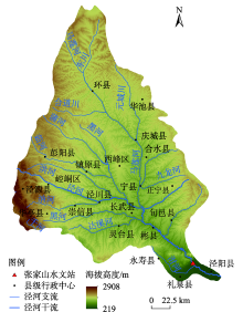
图1
研究区概况"

表1
数据来源"
| 数据类型 | 数据描述 | 数据来源 |
|---|---|---|
| 基础地理信息数据 | 行政区划、河流、道路等 | 国家基础地理信息中心( |
| 高程数据 | 来源于地理空间数据云,空间分辨率为30 m | 地理空间数据云( |
| 土壤数据 | 第二次全国土地调查南京土壤研究所提供的1:100000土壤数据,空间分辨率为1 km×1 km | 国家青藏高原科学数据中心( |
| 土地利用数据 | 来源于GlobalLand 30,全球地理信息公共产品,空间分辨率为30 m | 全球地理信息公共产品( |
| 气象数据 | 2000—2020年逐日数据,指标包括降水量、最高气温、最低气温、风速、相对湿度数据 | 国家气象科学数据中心( |
| 水文数据 | 2000—2020年张家山水文站逐日径流数据 | 张家山水文站( |
| 统计数据 | 2000—2020年人口密度以及GDP等统计数据 | 统计年鉴 |
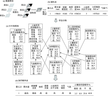
图2
生态系统服务贝叶斯网络构建原理 注:NPP为净初级生产力。下同。"

表2
因子状态分级"
| 因子 | 状态名称 | 实际值范围 |
|---|---|---|
| 蒸散发量/mm | 低 | 2256~3903 |
| 中 | 3903~5362 | |
| 高 | 5362~9827 | |
| 最高 | 9827~65534 | |
| 土地利用水平分级 | 低 | 1 |
| 中 | 2 | |
| 高 | 3 | |
| 最高 | 4 | |
| 植被覆盖度 | 低 | -0.17~0.14 |
| 中 | 0.14~0.30 | |
| 高 | 0.30~0.46 | |
| 最高 | 0.46~0.70 | |
| 水土保持措施因素 | 低 | 0.00 |
| 中 | 0.00~0.10 | |
| 高 | 0.10~0.35 | |
| 最高 | 0.35~1.00 | |
| 土壤类型 | 低 | 1~4 |
| 中 | 4~9 | |
| 高 | 9~14 | |
| 最高 | 14~20 | |
| 太阳辐射/MJ·m-2 | 低 | 4989~5331 |
| 中 | 5331~5576 | |
| 高 | 5576~5732 | |
| 最高 | 5732~5911 | |
| 降水量/mm | 低 | 323~422 |
| 中 | 422~506 | |
| 高 | 506~584 | |
| 最高 | 584~693 | |
| 坡度/(°) | 低 | 0.00~3.50 |
| 中 | 3.50~7.00 | |
| 高 | 7.00~10.50 | |
| 气温/℃ | 低 | <8 |
| 中 | 8~9 | |
| 高 | 9~10 | |
| 最高 | 10~12 | |
| 土地利用类型 | 耕地 | - |
| 林地 | - | |
| 草地 | - | |
| 水域 | - | |
| 建设用地 | - | |
| 未利用地 | - | |
| 土壤保持/t·hm-2 | 低 | 0.00~41.30 |
| 中 | 41.30~93.60 | |
| 高 | 93.60~174.14 | |
| 最高 | 174.14~555.09 | |
| 农业生产力/t·hm-2 | 低 | 28.64~57.75 |
| 中 | 57.75~60.00 | |
| 高 | 60.00~90.00 | |
| 最高 | 90.00~120.00 | |
| NPP/g C·m-2 | 低 | 0.23~11.97 |
| 中 | 11.97~135.89 | |
| 高 | 135.89~204.47 | |
| 最高 | 204.47~388.90 | |
| 产水量/m3 | 低 | 0.00~408.61 |
| 中 | 408.61~1001.75 | |
| 高 | 1001.75~2095.70 | |
| 最高 | 2095.70~3361.15 |
表3
参数敏感性分析"
| 参数名称 | 相对显著性(T) | 显著性检验(P) | 参数范围 | 最优校准值 |
|---|---|---|---|---|
| 土壤饱和导水率 | 2.5450 | 0.0112 | -0.9~0.9 | -0.8425 |
| 降雪温度 | -2.2385 | 0.0256 | -20~20 | 7.9700 |
| 主河道水力传导度 | 1.8577 | 0.0638 | 0~150 | 58.8517 |
| 地下水滞留系数 | -1.7717 | 0.0771 | 0~500 | 390.1691 |
| 土壤蒸发补偿系数 | -1.2422 | 0.2148 | 0.01~1.00 | 0.0294 |
| 土壤有效含水率 | -1.1148 | 0.2655 | -0.5~0.5 | 0.3959 |
| 土壤湿密度 | 1.0494 | 0.2945 | -0.5~0.5 | -0.4496 |
| 基流系数 | 0.5965 | 0.5512 | 0~1 | 0.9276 |
| 地下水再蒸发系数 | -0.5050 | 0.6138 | 0.02~0.20 | 0.1400 |
| 浅层地下水径流系数 | 0.0329 | 0.9737 | 0~5000 | 2409.2715 |
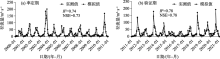
图3
率定期和验证期逐月径流量模拟值与实测值 注:R2为决定性系数;NSE为纳什效率系数。"

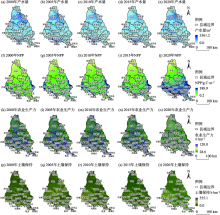
图4
泾河流域生态系统服务量空间变化与分布"

表4
农业生产力节点条件概率"
| 土地利用水平 | 蒸散发量 | 农业生产力 | |||
|---|---|---|---|---|---|
| 最高 | 高 | 中 | 低 | ||
| 最高 | 最高 | 0.353 | 0.002 | 0.284 | 0.361 |
| 高 | 高 | 0.229 | 0.032 | 0.620 | 0.119 |
| 中 | 高 | 0.099 | 0.111 | 0.299 | 0.491 |
| 低 | 中 | 0.108 | 0.422 | 0.282 | 0.188 |
表5
产水节点条件概率"
| 土地利用水平 | 降水量 | 气温 | 土地利用类型 | 产水量 | |||
|---|---|---|---|---|---|---|---|
| 最高 | 高 | 中 | 低 | ||||
| 最高 | 最高 | 高 | 未利用地 | 0.159 | 0.020 | 0.205 | 0.616 |
| 中 | 最高 | 低 | 未利用地 | 0.065 | 0.138 | 0.579 | 0.217 |
| 中 | 最高 | 低 | 草地 | 0.031 | 0.805 | 0.084 | 0.080 |
| 最高 | 最高 | 最高 | 草地 | 0.488 | 0.124 | 0.191 | 0.196 |
表6
NPP节点条件概率"
| 降水量 | 气温 | 土地利用类型 | 太阳辐射 | 植被覆盖度 | NPP | |||
|---|---|---|---|---|---|---|---|---|
| 最高 | 高 | 中 | 低 | |||||
| 中 | 最高 | 未利用地 | 最高 | 最高 | 0.060 | 0.024 | 0.878 | 0.039 |
| 低 | 低 | 未利用地 | 低 | 低 | 0.072 | 0.043 | 0.438 | 0.446 |
| 中 | 最高 | 草地 | 最高 | 最高 | 0.149 | 0.469 | 0.019 | 0.363 |
| 最高 | 最高 | 耕地 | 最高 | 最高 | 0.571 | 0.154 | 0.160 | 0.115 |
表7
土壤保持节点条件概率"
| 土壤类型 | 降水量 | 植被覆盖度 | 坡度 | 土壤保持措施因素 | 土壤保持 | |||
|---|---|---|---|---|---|---|---|---|
| 最高 | 高 | 中 | 低 | |||||
| 最高 | 最高 | 中 | 低 | 最高 | 0.126 | 0.056 | 0.320 | 0.499 |
| 最高 | 最高 | 最高 | 低 | 最高 | 0.191 | 0.135 | 0.458 | 0.215 |
| 最高 | 最高 | 最高 | 中 | 高 | 0.108 | 0.496 | 0.035 | 0.362 |
| 中 | 中 | 最高 | 中 | 中 | 0.824 | 0.007 | 0.139 | 0.029 |
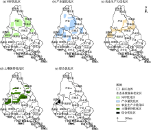
图5
综合生态系统服务优化区"

| [1] | Fu B J. Trade-off analyses and synthetic integrated method of multiple ecosystem[J]. Resources Science, 2016, 38(1): 5-10. |
| [2] |
Pedreschi D, Bouch P, Moriary M, et al. Integrated ecosystem analysis in Irish waters: Providing the context for ecosystem-based fisheries management[J]. Fisheries Research, 2019, 209: 218-229.
doi: 10.1016/j.fishres.2018.09.023 |
| [3] |
Newton A, Brito A C, Icely J D, et al. Assessing, quantifying and valuing the ecosystem services of coastal lagoons[J]. Journal for Nature Conservation, 2018, 44: 50-65.
doi: 10.1016/j.jnc.2018.02.009 |
| [4] |
Chen L C, Guan X, Li H M, et al. Spatiotemporal patterns of carbon storage in forest ecosystems in Hunan Province, China[J]. Forest Ecology and Management, 2019, 432: 656-666.
doi: 10.1016/j.foreco.2018.09.059 |
| [5] |
Luisetti T, Turner R K, Andrews J E, et al. Quantifying and valuing carbon flows and stores in coastal and shelf ecosystems in the UK[J]. Ecosystem Services, 2019, 35: 67-76.
doi: 10.1016/j.ecoser.2018.10.013 |
| [6] | Stritih A, Bebi P, Grêt-Regamey A. Quantifying uncertainties in earth observation-based ecosystem service assessments[J]. Environmental Modelling & Software, 2019, 111: 300-310. |
| [7] |
戴尔阜, 王晓莉, 朱建佳, 等. 生态系统服务权衡: 方法、模型与研究框架[J]. 地理研究, 2016, 35(6): 1005-1016.
doi: 10.11821/dlyj201606001 |
|
[ Dai Erfu, Wang Xiaoli, Zhu Jianjia, et al. Methods, tools and research framework of ecosystem service trade-offs[J]. Geographical Research, 2016, 35(6): 1005-1016. ]
doi: 10.11821/dlyj201606001 |
|
| [8] |
傅伯杰, 于丹丹. 生态系统服务权衡与集成方法[J]. 资源科学, 2016, 38(1): 1-9.
doi: 10.18402/resci.2016.01.01 |
|
[ Fu Bojie, Yu Dandan. Trade-off analyses and synthetic integrated method of multiple ecosystem services[J]. Resources Science, 2016, 38(1): 1-9. ]
doi: 10.18402/resci.2016.01.01 |
|
| [9] | 李婷, 李晶, 王彦泽, 等. 关中天水经济区生态系统固碳服务空间流动及格局优化[J]. 中国农业科学, 2017, 50(20): 3953-3969. |
| [ Li Ting, Li Jing, Wang Yanze, et al. The spatial flow and pattern optimization of carbon sequestration ecosystem service in Guanzhong Tianshui economical region[J]. Scientia Agricultura Sinica, 2017, 50(20): 3953-3969. ] | |
| [10] | 刘维, 周忠学, 郎睿婷. 城市绿色基础设施生态系统服务供需关系及空间优化--以西安市为例[J]. 干旱区地理, 2021, 44(5): 1500-1513. |
| [ Liu Wei, Zhou Zhongxue, Lang Ruiting. Supply-demand relations of ecosystem services of urban green infrastructure and its spatial optimization: A case of Xi’an City[J]. Arid Land Geography, 2021, 44(5): 1500-1513. ] | |
| [11] |
Dai F N, Quinn C, Morari F. A Bayesian belief network framework to predict SOC dynamics of alternative management scenarios[J]. Soil and Tillage Research, 2018, 179: 114-124.
doi: 10.1016/j.still.2018.01.002 |
| [12] |
Wu X, Wang S, Fu B J, et al. Land use optimization based on ecosystem service assessment: A case study in the Yanhe watershed[J]. Land Use Policy, 2018, 72: 303-312.
doi: 10.1016/j.landusepol.2018.01.003 |
| [13] |
傅伯杰, 张立伟. 土地利用变化与生态系统服务: 概念、方法与进展[J]. 地理科学进展, 2014, 33(4): 441-446.
doi: 10.11820/dlkxjz.2014.04.001 |
|
[ Fu Bojie, Zhang Liwei. Land-use change and ecosystem services: Concepts, methods and progress[J]. Progress in Geography, 2014, 33(4): 441-446. ]
doi: 10.11820/dlkxjz.2014.04.001 |
|
| [14] | 谢高地, 张彩霞, 张昌顺, 等. 中国生态系统服务的价值[J]. 资源科学, 2015, 37(9): 1740-1746. |
| [ Xie Gaodi, Zhang Caixia, Zhang Changshun, et al. The value of ecosystem services in China[J]. Resources Science, 2015, 37(9): 1740-1746. ] | |
| [15] | 肖玉, 谢高地, 鲁春霞, 等. 基于供需关系的生态系统服务空间流动研究进展[J]. 生态学报, 2016, 36(10): 3096-3102. |
| [ Xiao Yu, Xie Gaodi, Lu Chunxia, et al. Involvement of ecosystem service flows in human wellbeing based on the relationship between supply and demand[J]. Acta Ecologica Sinica, 2016, 36(10): 3096-3102. ] | |
| [16] |
龚建周, 刘彦随, 张灵. 广州市土地利用结构优化配置及其潜力[J]. 地理学报, 2010, 65(11): 1391-1400.
doi: 10.11821/xb201011009 |
|
[ Gong Jianzhou, Liu Yansui, Zhang Ling. The optimal allocation of land use and its potential appraisal in Guangzhou City[J]. Acta Geographica Sinica, 2010, 65(11): 1391-1400. ]
doi: 10.11821/xb201011009 |
|
| [17] | 刘慧灵, 伍世代, 韦素琼, 等. 基于低碳经济导向的土地利用结构优化研究--以福建省福州市为例[J]. 水土保持通报, 2017, 37(6): 202-208. |
| [ Zhang Huiling, Wu Shidai, Wei Suqiong, et al. Optimization research of low-carbon economy oriented land use structure: A case study in Fuzhou City of Fujian Province[J]. Bulletin of Soil and Water Conservation, 2017, 37(6): 202-208. ] | |
| [18] | 王观湧, 张乐, 于化龙, 等. 基于生态安全的土地利用结构优化研究[J]. 土壤通报, 2015, 46(6): 1322-1327. |
| [ Wang Guanyong, Zhang Le, Yu Hualong, et al. Research on optimization of land use structure in Baoding urban agglomeration based on ecological security[J]. Chinese Journal of Soil Science, 2015, 46(6): 1322-1327. ] | |
| [19] | 向芸芸, 蒙吉军. 基于生态效益的武汉城市圈土地利用结构优化[J]. 长江流域资源与环境, 2013, 22(10): 1297-1304. |
| [ Xiang Yunyun, Meng Jijun. Research on optimization of land use structure in Wuhan urban agglomeration based on ecological security benefit[J]. Resources and Environment in the Yangtze Basin, 2013, 22(10): 1297-1304. ] | |
| [20] | 李秀霞, 徐龙, 江恩赐. 基于系统动力学的土地利用结构多目标优化[J]. 农业工程学报, 2013, 29(16): 247-254. |
| [ Li Xiuxia, Xu Long, Jiang Enci. Multi-objective optimization of land use structure in western Jilin Province based on system dynamics[J]. Transactions of the Chinese Society of Agricultural Engineering, 2013, 29(16): 247-254. ] | |
| [21] |
Landuyt D, Broekx S, Goethals P L M. Bayesian belief networks to analyse trade-offs among ecosystem services at the regional scale[J]. Ecological Indicators, 2016, 71: 327-335.
doi: 10.1016/j.ecolind.2016.07.015 |
| [22] |
曾莉, 李晶, 李婷, 等. 基于贝叶斯网络的水源涵养服务空间格局优化[J]. 地理学报, 2018, 73(9): 1809-1822.
doi: 10.11821/dlxb201809015 |
|
[ Zeng Li, Li Jing, Li Ting, et al. Optimizing spatial patterns of water conservation ecosystem service based on Bayesian belief networks[J]. Acta Geographica Sinica, 2018, 73(9): 1809-1822. ]
doi: 10.11821/dlxb201809015 |
|
| [23] |
Fox W E, Medina-Cetina Z, Angerer J, et al. Water quality & natural resource management on military training lands in central Texas: Improved decision support via Bayesian networks[J]. Sustainability of Water Quality and Ecology, 2017, 9-10: 39-52.
doi: 10.1016/j.swaqe.2017.03.001 |
| [24] |
Landuyt D, Lemmens P, D’hondt R, et al. An ecosystem service approach to support integrated pond management: A case study using Bayesian belief networks-highlighting opportunities and risks[J]. Journal of Environmental Management, 2014, 145: 79-87.
doi: 10.1016/j.jenvman.2014.06.015 pmid: 25005053 |
| [25] |
Dang K B, Windhorst W, Burkhard B, et al. A Bayesian belief network: Based approach to link ecosystem functions with rice provisioning ecosystem services[J]. Ecological Indicators, 2019, 100: 30-44.
doi: 10.1016/j.ecolind.2018.04.055 |
| [26] |
Chen C, Xie G, Zhen L, et al. Analysis on Jinghe River watershed vegetation dynamics and evaluation on its relation with precipitation[J]. Acta Ecologica Sinica, 2008, 28(3): 925-938.
doi: 10.1016/S1872-2032(08)60032-3 |
| [27] | Xie G D, Zhen L, Chen C, et al. The changes and their interactions of precipitation-landscape-runoff in Jinghe Watershed[J]. Resources Science, 2007, 29(2): 156-163. |
| [28] | Guo A, Chang J, Wang Y, et al. Variation characteristics of rainfall-run relationship and driving factors analysis in Jinghe River Basin in nearly 50 years[J]. Transactions of the Chinese Society of Agricultural Engineering, 2015, 31(14): 165-171. |
| [29] | 甄霖, 谢高地, 杨丽, 等. 基于参与式社区评估法的泾河流域景观管理问题分析[J]. 中国人口·资源与环境, 2007, 17(3): 129-133. |
| [ Zhen Lin, Xie Gaodi, Yang Li, et al. Challenges facing landscape management in the Jinghe watershed of northwest China by using participatory rual apprise[J]. China Population, Resources and Environment, 2007, 17(3): 129-133. ] | |
| [30] | 麻馨月, 杨洋, 娄成武. 21世纪以来环渤海地区耕地生产潜力时空动态[J]. 中国人口·资源与环境, 2016, 26(增刊1): 226-231. |
| [ Ma Xinyue, Lou Chengwu. Spatiotemporal dynamics of cultivated land potential productivity in Bohai Rim since the 21st Century[J]. China Population, Resources and Environment, 2016, 26(Suppl. 1): 226-231. ] | |
| [31] |
Zheng Z, Fu B J, Hu H, et al. A method to identify the variable ecosystem services relationship across time: A case study on Yanhe Basin, China[J]. Landscape Ecology, 2014, 29(10): 1689-1696.
doi: 10.1007/s10980-014-0088-x |
| [32] | Neitsch S L, Arnold J G, Kiniry J R, et al. Soil and water assessment tool, theoretical documentation, Version 2000[M]. College Station, Texas: Texas Water Resources Institute, 2002. |
| [33] |
杨晓楠, 李晶, 秦克玉, 等. 关中天水经济区生态系统服务的权衡关系[J]. 地理学报, 2015, 70(11): 1762-1773.
doi: 10.11821/dlxb201511006 |
|
[ Yang Xiaonan, Li Jing, Qin Keyu, et al. Trade-offs between ecosystem services in Guanzhong Tianshui Economic Region[J]. Acta Geographica Sinica, 2015, 70(11): 1762-1773. ]
doi: 10.11821/dlxb201511006 |
|
| [34] |
朱文泉, 潘耀忠, 张锦水. 中国陆地植被净初级生产力遥感估算[J]. 植物生态学报, 2007, 31(3): 413-424.
doi: 10.17521/cjpe.2007.0050 |
|
[ Zhu Wenquan, Pan Yaozhong, Zhang Jinshui. Estimation of net primary productivity of Chinese terrestrial vegetation based on remote sensing[J]. Chinese Journal of Plant Ecology, 2007, 31(3): 413-424. ]
doi: 10.17521/cjpe.2007.0050 |
|
| [35] |
Peng H, Jia Y, Niu C, et al. Eco-hydrological simulation of soil and water conservation in the Jinghe River Basin in the Loess Plateau, China[J]. Journal of Hydro-environment Research, 2015, 9(3): 452-464.
doi: 10.1016/j.jher.2014.09.003 |
| [36] | Wischmeier W H, Smith D D. Predicting rainfall-erosion losses:A guide to conservation planning, agricultural handbook No.537[M]. Washington DC: US Department of Agriculture, 1978. |
| [37] | 李硕豪, 张军. 贝叶斯网络结构学习综述[J]. 计算机应用研究, 2015, 32(3): 641-646. |
| [ Li Shuohao, Zhang Jun. Review of Bayesian networks structure learning[J]. Application Research of Computers, 2015, 32(3): 641-646. ] | |
| [38] |
Macpherson M P, Webb E B, Raedeke A, et al. A review of Bayesian belief network models as decision-support tools for wetland conservation: Are water bird’s potential umbrella taxa?[J]Biological Conservation, 2018, 226: 215-223.
doi: 10.1016/j.biocon.2018.08.001 |
| [39] | Salliou N, Barnaud C, Vialatie A, et al. A participatory Bayesian belief network approach to explore ambiguity among stakeholders about socio-ecological systems[J]. Environmental Modelling & Software, 2017, 96: 199-209. |
| [40] |
Dai W, Fu W, Jiang P, et al. Spatial pattern of carbon stocks in forest ecosystems of a typical subtropical region of southeastern China[J]. Forest Ecology and Management, 2018, 409: 288-297.
doi: 10.1016/j.foreco.2017.11.036 |
| [41] |
Kleemann J, Celio E, Nyarko B K, et al. Assessing the risk of seasonal food insecurity with an expert-based Bayesian belief network approach in northern Ghana, West Africa[J]. Ecological Complexity, 2017, 32: 53-73.
doi: 10.1016/j.ecocom.2017.09.002 |
| [42] |
李晶, 周自翔. 延河流域景观格局与生态水文过程分析[J]. 地理学报, 2014, 69(7): 933-944.
doi: 10.11821/dlxb201407006 |
|
[ Li Jing, Zhou Zixiang. Landscape pattern and hydrological processes in Yanhe River Basin of China[J]. Acta Geographica Sinica, 2014, 69(7): 933-944. ]
doi: 10.11821/dlxb201407006 |
|
| [43] | Jiang Y, Wang L, Wei X, et al. Impacts of climate change on runoff of Jinghe River based on SWAT model[J]. Transactions of the Chinese Society for Agricultural Machinery, 2017, 48(2): 262-270. |
| [44] | 刘宇, 管子隆, 田济扬, 等. 近70a泾河流域径流变化及其驱动因素研究[J]. 干旱区地理, 2022, 45(1): 17-26. |
| [ Liu Yu, Guan Zilong, Tian Jiyang, et al. Study on runoff change and its driving factors in Jinghe River Basin in recent 70 years[J]. Arid Land Geography, 2022, 45(1): 17-26. ] | |
| [45] | 黄晨璐, 杨勤科. 渭河与泾河流域水沙变化规律及其差异性分析[J]. 干旱区地理, 2021, 44(2): 327-336. |
| [ Huang Chenlu, Yang Qinke. Runoff and sediment variation rules and differences in Wei River and Jing River Basins[J]. Arid Land Geography, 2021, 44(2): 327-336. ] | |
| [46] | 卞鸿雁, 庞奖励, 任志远. 泾河流域固碳释氧功能的时空动态测评[J]. 陕西师范大学学报(自然科学版), 2013, 41(2): 94-99. |
| [ Bian Hongyan, Pang Jiangli, Ren Zhiyuan. The spatial and temporal changes of carbon fixation and oxygen release in Jinghe River Basin[J]. Journal of Shaanxi Normal University (Natural Science Edition), 2013, 41(2): 94-99. ] | |
| [47] |
Zheng T, Zhou Z, Zou Y, et al. Analysis of spatial and temporal characteristics and spatial flow process of soil conservation service in Jinghe Basin of China[J]. Sustainability, 2021, 13(4): 1794, doi: 10.3390/su13041794.
doi: 10.3390/su13041794 |
| [48] | 杨莉, 甄霖, 李芬, 等. 黄土高原生态系统服务变化对人类福祉的影响初探[J]. 资源科学, 2010, 32(5): 849-855. |
| [ Yang Li, Zeng Lin, Li Fen, et al. Impacts of ecosystem services change on human well-being in the Loess Plateau[J]. Resources Science, 2010, 32(5): 849-855. ] | |
| [49] |
Olschewski R, Benítez P C. Optimizing joint production of timber and carbon sequestration of afforestation projects[J]. Journal of Forest Economics, 2010, 16(1): 1-10.
doi: 10.1016/j.jfe.2009.03.002 |
| [50] |
Hoover C M, Heath L S. Potential gains in C storage on productive forestlands in the northeastern United States through stocking management[J]. Ecological Applications, 2011, 21: 1154-1161.
doi: 10.1890/10-0046.1 |
| [51] | Chen S H, Pollino C A. Good practice in Bayesian network modelling[J]. Environmental Modelling & Software, 2012, 37(17): 134-145. |
| [1] | 彭娅, 王娟娟, 王珊珊, 田柳兰, 刘婕, 毋兆鹏. 生态安全视角下乌鲁木齐市土地利用冲突时空格局演变分析[J]. 干旱区地理, 2024, 47(1): 81-92. |
| [2] | 李洪庆,杨瑀,张俊红. 雅鲁藏布江山南宽谷流域生态安全格局构建[J]. 干旱区地理, 2023, 46(9): 1503-1513. |
| [3] | 周凡,周冬梅,金银丽,马静,杨静,朱小燕,张军. 疏勒河流域生态系统服务供需空间匹配特征[J]. 干旱区地理, 2023, 46(3): 471-480. |
| [4] | 马丽娜, 张飞云, 翟玉鑫, 滕伦, 康建国. 1980—2020年新疆土地利用变化下生态系统服务价值时空演变分析[J]. 干旱区地理, 2023, 46(2): 253-263. |
| [5] | 隋露, 蒲春玲, 刘志有, 柏鹏飞, 刘涛. 基于PLUS模型的乌鲁木齐市生态服务价值权衡协同探究[J]. 干旱区地理, 2023, 46(1): 159-168. |
| [6] | 颉茂华, 孙佳文, 刘铁鑫. 中国资源型城市生态系统服务价值评价——基于Meta模型视角[J]. 干旱区地理, 2022, 45(6): 1949-1957. |
| [7] | 张凯莉,冯荣荣,刘潭,张志成,韩佳宁,刘康. 黄河流域城市化与生态系统服务价值协调性及障碍因素研究[J]. 干旱区地理, 2022, 45(4): 1254-1267. |
| [8] | 杨海娟,孙来玎,周美君,李飞. 黄土高原粮食生产空间重构过程中的生态系统服务权衡——以陕北榆林市为例[J]. 干旱区地理, 2022, 45(1): 226-236. |
| [9] | 刘宇,管子隆,田济扬,刘荣华,关荣浩. 近70 a泾河流域径流变化及其驱动因素研究[J]. 干旱区地理, 2022, 45(1): 17-26. |
| [10] | 安斯文,马彩虹,袁倩颖,滑雨琪. 生态移民区“三生”用地变化对生态系统服务的影响——以宁夏红寺堡区为例[J]. 干旱区地理, 2021, 44(6): 1836-1846. |
| [11] | 潘换换,吴树荣,杨琪雪,杜自强,武志涛,张红. 山西煤田生态系统服务热(冷)点时空格局[J]. 干旱区地理, 2021, 44(6): 1686-1695. |
| [12] | 刘维,周忠学,郎睿婷. 城市绿色基础设施生态系统服务供需关系及空间优化--以西安市为例[J]. 干旱区地理, 2021, 44(5): 1500-1513. |
| [13] | 张帅,汪洋,夏婷婷,常雪儿,李稚. 塔里木河生态输水条件下土地利用/覆被变化对生态系统服务价值的影响[J]. 干旱区地理, 2021, 44(3): 739-749. |
| [14] | 王波,杨太保. 1980—2018年银川市生态系统服务价值评价及驱动力分析[J]. 干旱区地理, 2021, 44(2): 552-564. |
| [15] | 王一山,张飞,陈瑞,齐亚霄,刘长江. 乌鲁木齐市土地生态安全综合评价[J]. 干旱区地理, 2021, 44(2): 427-440. |
|
||