- 2025年4月27日 星期日
干旱区地理 ›› 2021, Vol. 44 ›› Issue (3): 739-749.doi: 10.12118/j.issn.1000–6060.2021.03.16
张帅1( ),汪洋1(),夏婷婷1,常雪儿1,李稚2
收稿日期:2021-02-02
修回日期:2021-02-25
出版日期:2021-05-25
发布日期:2021-06-01
通讯作者:
汪洋
作者简介:张帅(1995-),男,硕士研究生,主要从事干旱区草地生态等方面的研究. E-mail: 基金资助:
ZHANG Shuai1(),WANG Yang1(),XIA Tingting1,CHANG Xue’er1,LI Zhi2
Received:2021-02-02
Revised:2021-02-25
Online:2021-05-25
Published:2021-06-01
Contact:
Yang WANG
摘要:
基于2000—2020年土地利用数据,采用修正后的单位面积价值当量法、生态系统服务变化指数与探索性空间分析手段,分析了塔里木河下游自生态输水以来生态系统服务功能的时空变化特征。结果表明:(1)自2000年生态输水以来,塔里木河下游耕地、林地和草地面积分别增长了18.6 km2、54.7 km2和76.7 km2,裸地面积减少了104.0 km2;其中耕地和林地增长面积主要分布在大西海子水库—英苏段,草地增长面积主要分布在英苏—阿拉干段和阿拉干—台特玛湖段。(2)塔里木河下游生态系统服务价值由2000年的42.66×10⁹元增长到了2020年的45.86×10⁹元,增长了3.20×10⁹元,且生态系统服务价值低值土地利用类型向高值土地利用类型转化频繁。(3)塔里木河下游生态系统服务价值Global Moran’s I由2000年的0.7552增长到2020年的0.7639,该地区生态系统服务价值存在明显的正向空间自相关关系,且增值区主要集中分布在大西海子水库—英苏段,损失区主要分布在英苏—阿拉干段和阿拉干—台特玛湖段。塔里木河下游生态输水对该地区生态环境修复起到了积极的作用,有效提升了该区域的生态系统服务价值。
张帅,汪洋,夏婷婷,常雪儿,李稚. 塔里木河生态输水条件下土地利用/覆被变化对生态系统服务价值的影响[J]. 干旱区地理, 2021, 44(3): 739-749.
ZHANG Shuai,WANG Yang,XIA Tingting,CHANG Xue’er,LI Zhi. Effects of land use/cover change on ecosystem service value under the ecological water conveyance of Tarim River[J]. Arid Land Geography, 2021, 44(3): 739-749.

图1
研究区示意图"
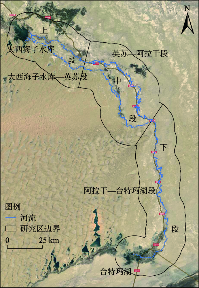
表1
塔里木河下游生态系统服务价值(ESV)系数"
| 生态系统服务功能 | 土地利用类型 | ||||
|---|---|---|---|---|---|
| 耕地 | 林地 | 草地 | 建设用地 | 裸地 | |
| 气体调节 | 940.91 | 6586.37 | 1505.46 | 0.00 | 0.00 |
| 气候调节 | 1674.82 | 5080.92 | 1693.64 | 0.00 | 0.00 |
| 水源涵养 | 1129.09 | 6021.83 | 1505.46 | 0.00 | 56.45 |
| 土壤形成与保护 | 2747.46 | 7339.10 | 3669.55 | 0.00 | 37.64 |
| 废物处理 | 3086.19 | 2465.18 | 2465.18 | 0.00 | 18.82 |
| 生物多样性保护 | 1336.09 | 6134.74 | 2051.18 | 0.00 | 639.82 |
| 食物生产 | 1881.82 | 188.18 | 564.55 | 0.00 | 18.82 |
| 原材料生产 | 188.18 | 4892.73 | 94.09 | 0.00 | 0.00 |
| 娱乐文化 | 18.82 | 2408.73 | 75.27 | 82.60 | 18.82 |
| 合计 | 13003.38 | 41117.78 | 13624.38 | 82.60 | 790.36 |
表2
2000—2020年塔里木河下游各土地利用类型面积"
| 土地利用类型 | 2000年 | 2005年 | 2010年 | 2015年 | 2020年 | 2000—2020年 |
|---|---|---|---|---|---|---|
| 耕地 | 3.68 | 3.82 | 3.82 | 3.93 | 5.54 | 1.86 |
| 林地 | 37.25 | 39.59 | 39.57 | 42.6 | 42.72 | 5.47 |
| 草地 | 182.35 | 178.57 | 185.26 | 184.27 | 190.02 | 7.67 |
| 建设用地 | 0.50 | 0.50 | 0.50 | 0.50 | 0.50 | 0.00 |
| 裸地 | 255.24 | 246.76 | 245.77 | 244.84 | 244.84 | -10.40 |
图2
2000—2020年塔里木河下游各土地利用类型的空间分布"
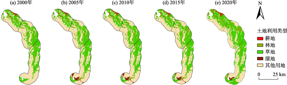
表3
2000—2020年塔里木河下游植被覆盖类型面积"
| 植被覆盖类型 | 塔里木下游区段 | 2000年 | 2005年 | 2010年 | 2015年 | 2020年 | 2010—2020年 |
|---|---|---|---|---|---|---|---|
| 耕地 | 大西海子水库—英苏段 | 3.68 | 3.82 | 3.82 | 3.93 | 5.54 | 1.86 |
| 英苏—阿拉干段 | 0.00 | 0.00 | 0.00 | 0.00 | 0.00 | 0.00 | |
| 阿拉干—台特玛湖段 | 0.00 | 0.00 | 0.00 | 0.00 | 0.00 | 0.00 | |
| 林地 | 大西海子水库—英苏段 | 7.88 | 7.88 | 7.88 | 7.86 | 13.35 | 5.47 |
| 英苏—阿拉干段 | 21.71 | 21.64 | 21.63 | 24.68 | 22.68 | 0.97 | |
| 阿拉干—台特玛湖段 | 7.66 | 10.07 | 10.06 | 10.06 | 6.69 | -0.97 | |
| 草地 | 大西海子水库—英苏段 | 43.54 | 43.42 | 50.13 | 50.05 | 46.09 | 2.55 |
| 英苏—阿拉干段 | 60.49 | 61.34 | 61.33 | 58.81 | 61.99 | 1.50 | |
| 阿拉干—台特玛湖段 | 78.32 | 73.81 | 73.80 | 75.41 | 81.94 | 3.62 |
表4
2000—2020年塔里木河下游生态系统服务价值(ESV)"
| 土地利用类型 | 2000年 | 2005年 | 2010年 | 2015年 | 2020年 | |||||
|---|---|---|---|---|---|---|---|---|---|---|
| ESV/108元 | 占比/% | ESV/108元 | 占比/% | ESV/108元 | 占比/% | ESV/108元 | 占比/% | ESV/108元 | 占比/% | |
| 耕地 | 0.48 | 1.13 | 0.50 | 1.16 | 0.50 | 1.14 | 0.51 | 1.17 | 0.51 | 1.11 |
| 林地 | 15.32 | 35.91 | 16.28 | 37.81 | 16.27 | 37.02 | 15.90 | 36.59 | 17.52 | 38.21 |
| 草地 | 24.84 | 58.22 | 24.33 | 56.50 | 25.24 | 57.43 | 25.11 | 57.80 | 25.89 | 56.45 |
| 建设用地 | 0.00 | 0.00 | 0.00 | 0.00 | 0.00 | 0.00 | 0.00 | 0.00 | 0.00 | 0.00 |
| 裸地 | 2.02 | 4.74 | 1.95 | 4.53 | 1.94 | 4.41 | 1.93 | 4.44 | 1.94 | 4.23 |
| 合计 | 42.66 | 100.00 | 43.06 | 100.00 | 43.95 | 100.00 | 43.45 | 100.00 | 45.86 | 100.00 |
表5
2000—2020年塔里木河下游各项生态系统服务类型价值"
| 一级类型 | 二级类型 | 2000年 | 2005年 | 2010年 | 2015年 | 2020年 |
|---|---|---|---|---|---|---|
| 调节服务 | 气体调节 | 5.23 | 5.33 | 5.43 | 5.36 | 5.70 |
| 气候调节 | 5.04 | 5.10 | 5.21 | 5.15 | 5.45 | |
| 水源涵养 | 5.18 | 5.25 | 5.35 | 5.28 | 5.61 | |
| 废物处理 | 5.58 | 5.54 | 5.71 | 5.66 | 5.90 | |
| 小结 | 21.03 | 21.22 | 21.7 | 21.45 | 22.66 | |
| 支持服务 | 土壤形成与保护 | 9.62 | 9.66 | 9.90 | 9.80 | 10.30 |
| 生物多样性保护 | 7.71 | 7.73 | 7.85 | 7.77 | 8.14 | |
| 小结 | 17.33 | 17.39 | 17.75 | 17.57 | 18.44 | |
| 供给服务 | 食物生产 | 1.22 | 1.20 | 1.24 | 1.23 | 1.27 |
| 原材料生产 | 2.00 | 2.11 | 2.12 | 2.07 | 2.27 | |
| 小结 | 3.22 | 3.31 | 3.36 | 3.3 | 3.54 | |
| 文化服务 | 娱乐文化 | 1.08 | 1.14 | 1.14 | 1.13 | 1.22 |
| 合计 | 42.66 | 43.06 | 43.95 | 43.45 | 45.86 |

图3
2000—2020年塔里木河下游ESV及其损益变化的空间分布 注:ESV为生态系统服务价值;ESCI为生态系统服务价值损益变化。下同。"
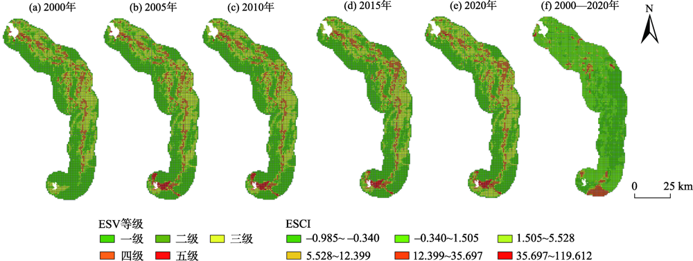
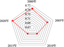
图4
2000—2020年塔里木河下游ESV全局莫兰指数"


图5
2000—2020年塔里木河下游ESV的LISA聚类图"


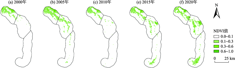
图6
2000—2020年塔里木河下游归一化植被指数(NDVI)空间分布"
| [1] |
Darvill R, Lindo Z. The inclusion of stakeholders and cultural ecosystem services in land management trade-off decisions using an ecosystem services approach[J]. Landscape Ecology, 2016,31(3):533-545.
doi: 10.1007/s10980-015-0260-y |
| [2] |
Nelson E, Mendoza G, Regetz J, et al. Modeling multiple ecosystem services, biodiversity conservation, commodity production, and tradeoffs at landscape scales[J]. Frontiers in Ecology and the Environment, 2009,7(1):4-11.
doi: 10.1890/080023 |
| [3] | 孙庆祥, 周华荣. 阿尔泰山森林生态系统服务功能及其价值评估[J]. 干旱区地理, 2020,43(5):1327-1336. |
| [ Sun Qingxiang, Zhou Huarong. Service function and value evaluation of the Altai Mountains forest ecosystem[J]. Acta Ecologica Sinica, 2020,43(5):1327-1336. ] | |
| [4] |
Costanza R, D’Arge R, Groot R D, et al. The value of the world’s ecosystem services and natural capital[J]. Nature, 1997,387(6630):253-260.
doi: 10.1038/387253a0 |
| [5] |
Sun J. Research advances and trends in ecosystem services and evaluation in China[J]. Procedia Environmental Sciences, 2011,10:1791-1796.
doi: 10.1016/j.proenv.2011.09.280 |
| [6] |
Wang Z Y, Cao J S. Assessing and predicting the impact of multi-scenario land use changes on the ecosystem service value: A case study in the upstream of Xiong’an new area, China[J]. Sustainability, 2021,13(2):704-704.
doi: 10.3390/su13020704 |
| [7] | 谢高地, 张彩霞, 张昌顺, 等. 中国生态系统服务的价值[J]. 资源科学, 2005,37(9):1740-1746. |
| [ Xie Gaodi, Zhang Caixia, Zhang Changshun, et al. The value of ecosystem services in China[J]. Resources Science, 2005,37(9):1740-1746. ] | |
| [8] | 陈亚宁, 李卫红, 陈亚鹏, 等. 科技支撑新疆塔里木河流域生态修复及可持续管理[J]. 干旱区地理, 2018,41(5):901-907. |
| [ Chen Yaning, Li Weihong, Chen Yapeng, et al. Science in supporting the ecological restoration and sustainable development of the Tarim River Basin[J]. Arid Land Geography, 2018,41(5):901-907. ] | |
| [9] | 陈亚宁, 叶朝霞, 毛晓辉, 等. 新疆塔里木河断流趋势分析与减缓对策[J]. 干旱区地理, 2009,32(6):813-820. |
| [ Chen Yaning, Ye Zhaoxia, Mao Xiaohui, et al. Dried-up trend of Tarim River and the countermeasures for mitigation[J]. Arid Land Geography, 2009,32(6):813-820. ] | |
| [10] |
黄粤, 包安明, 王士飞, 等. 间歇性输水影响下的2001—2011年塔里木河下游生态环境变化[J]. 地理学报, 2013,68(9):1251-1262.
doi: 10.11821/dlxb201309008 |
|
[ Huang Yue, Bao Anming, Wang Shifei, et al. Eco-environmental change in the lower Tarim River under the influence of intermittent water transpor[J]. Journal of Geographical Sciences, 2013,68(9):1251-1262. ]
doi: 10.11821/dlxb201309008 |
|
| [11] | 李丽君, 张小清, 陈长清, 等. 近20 a塔里木河下游输水对生态环境的影响[J]. 干旱区地理, 2018,41(2):238-247. |
| [ Li Lijun, Zhang Xiaoqing, Chen Changqing, et al. Ecological effects of water conveyance on the lower reaches of Tarim River in recent twenty years[J]. Arid Land Geography, 2018,41(2):238-247. ] | |
| [12] | 古力米热·哈那提, 王光焰, 张音, 等. 干旱区间歇性生态输水对地下水位与植被的影响机理研究[J]. 干旱区地理, 2018,41(4):726-733. |
| [ Hanati Gulimire, Wang Guangyan, Zhang Yin, et al. Influence mechanism of intermittent ecological water conveyance on groundwater level and vegetation in arid land[J]. Arid Land Geography, 2018,41(4):726-733. ] | |
| [13] | 王珊珊, 王金林, 周可法. 塔里木河下游土地利用/覆被变化对生态输水的响应[J]. 水资源保护, 2021,37(2):69-74, 80. |
| [ Wang Shanshan, Wang Jinglin, Zhou Kefa. Response of land use/land cover change to ecological water transmission in the lower reach of Tarim River[J]. Water Resources Protection , 2021,37(2):69-74, 80. ] | |
| [14] | 王希义, 徐海量, 凌红波, 等. 生态输水对塔里木河下游植被恢复价值的影响[J]. 干旱地区农业研究, 2017,35(4):160-166. |
| [ Wang Xiyi, Xu Hailiang, Ling Hongbo, et al. Effects of ecological water conveyance on recovery value of vegetation in the lower reaches of Tarim River[J]. Agricultural Research in the Arid Areas, 2017,35(4):160-166. ] | |
| [15] | 陈亚宁, 李卫红, 陈亚鹏, 等. 新疆塔里木河下游断流河道输水与生态恢复[J]. 生态学报, 2007,27(2):538-545. |
| [ Chen Yaning, Li Weihong, Chen Yapeng, et al. Water conveyance in dried-up riverway and ecological restoration in the lower reaches of Tarim River, China[J]. Acta Ecologica Sinica, 2007,27(2):538-545. ] | |
| [16] |
Hao X M, Li W H. Impacts of ecological water conveyance on groundwater dynamics and vegetation recovery in the lower reaches of the Tarim River in northwest China[J]. Environmental Monitoring and Assessment, 2014,186:7605-7616.
doi: 10.1007/s10661-014-3952-x |
| [17] |
蔚亮, 李均力, 包安明, 等. 塔里木河下游湿地面积时序变化及对生态输水的响应[J]. 植物生态学报, 2020,44(6):616-627.
doi: 10.17521/cjpe.2019.0267 |
|
[ Wei Liang, Li Junli, Bao Anming, et al. Temporal areal changes of wetlands in the lower reaches of the Tarim River and their responses to ecological water conveyance[J]. Chinese Journal of Plant Ecology, 2020,44(6):616-627. ]
doi: 10.17521/cjpe.2019.0267 |
|
| [18] |
朱长明, 李均力, 沈占锋, 等. 塔里木河下游生态环境变化时序监测与对比分析[J]. 地球信息科学学报, 2019,21(3):437-444.
doi: 10.12082/dqxxkx.2019.180523 |
|
[ Zhu Changming, Li Junli, Shen Zhanfeng, et al. Time series monitoring and comparative analysis on eco-environment change in the lower reaches of the Tarim River[J]. Journal of Geo-information Science, 2019,21(3):437-444. ]
doi: 10.12082/dqxxkx.2019.180523 |
|
| [19] |
王希义, 彭淑贞, 徐海量, 等. 大型输水工程的生态效益与社会经济效益评价——以塔里木河下游为例[J]. 地理科学, 2020,40(2):308-314.
doi: 10.13249/j.cnki.sgs.2020.02.016 |
|
[ Wang Xiyi, Peng Shuzhen, Xu Hailiang, et al. Evaluation of ecological and social-economic benefits of large water conveyance projects: A case study on the lower reaches of the Tarim River[J]. Scientia Geographica Sinica, 2020,40(2):308-314. ]
doi: 10.13249/j.cnki.sgs.2020.02.016 |
|
| [20] | 刘纪远, 匡文慧, 张增祥, 等. 20世纪80年代末以来中国土地利用变化的基本特征与空间格局[J]. 地理学报, 2014,69(1):3-14. |
| [ Liu Jiyuan, Kuang Wenhui, Zhang Zengxiang, et al. Spatiotemporal characteristics, patterns and causes of land use changes in China since the late 1980s[J]. Journal of Geographical Sciences, 2014,69(1):3-14. ] | |
| [21] | 新疆维吾尔自治区统计局. 新疆统计年鉴[M]. 北京: 中国统计出版社, 1990—2018. |
| [ Statistics Bureau of Xinjiang Uygur Autonomous Region. Xinjiang Statistical Yearbook[M]. Beijing: China Statistics Press, 1990—2018. ] | |
| [22] | 新疆生产建设兵团统计局. 新疆生产建设兵团统计年鉴[M]. 北京: 中国统计出版社, 1990—2018. |
| [ Statistics Bureau of Xinjiang Production and Construction Corps. Statistical yearbook of Xinjiang Production and Construction Corps[M]. Beijing: China Statistics Press, 1990—2018. ] | |
| [23] | 谢高地, 张彩霞, 张雷明, 等. 基于单位面积价值当量因子的生态系统服务价值化方法改进[J]. 自然资源学报, 2015,30(8):1243-1254. |
| [ Xie Gaodi, Zhang Caixia, Zhang Leiming, et al. Improvement of the evaluation method for ecosystem service value based on per unit area[J]. Journal of Natural Resources, 2015,30(8):1243-1254. ] | |
| [24] | 丁丽莲, 王奇, 陈欣, 等. 近30年淀山湖地区生态系统服务价值对土地利用变化的响应[J]. 生态学报, 2019,39(8):2973-2985. |
| [ Ding Lilian, Wang Qi, Chen Xin, et al. The responses of ecosystem services to land-use change in Dianshan Lake area from 1984 to 2014[J]. Acta Ecologica Sinica, 2019,39(8):2973-2985. ] | |
| [25] | 祖皮艳木·买买提, 海米提·依米提, 安尼瓦尔·艾则孜, 等. 焉耆盆地生态系统服务价值对土地利用/覆被变化的响应[J]. 中国沙漠, 2014,34(1):275-283. |
| [ Maimaiti Zupiyanmu, Yimiti Haimiti, Aizez Anniwaer, et al. Response of ecosystem services value to land use/cover change in the Yanqi Basin of Xinjiang, China[J]. Journal of Desert Research, 2014,34(1):275-283. ] | |
| [26] |
Ling H B, Yan J J, Xu H L, et al. Estimates of shifts in ecosystem service values due to changes in key factors in the Manas River Basin, northwest China[J]. Science of the Total Environment, 2019,659:177-187.
doi: 10.1016/j.scitotenv.2018.12.309 |
| [27] |
钱彩云, 巩杰, 张金茜, 等. 甘肃白龙江流域生态系统服务变化及权衡与协同关系[J]. 地理学报, 2018,73(5):868-879.
doi: 10.11821/dlxb201805007 |
|
[ Qian Caiyun, Gong Jie, Zhang Jinxi, et al. Change and tradeoffs-synergies analysis on watershed ecosystem services: A case study of Bailongjiang Watershed, Gansu[J]. Journal of Geographical Sciences, 2018,73(5):868-879. ]
doi: 10.11821/dlxb201805007 |
|
| [28] |
Li G D, Fang C L, Wang S J. Exploring spatiotemporal changes in ecosystem-service values and hotspots in China[J]. Science of the Total Environment, 2016, 545-546:609-620.
doi: 10.1016/j.scitotenv.2015.12.067 |
| [29] | 郭椿阳, 高尚, 周伯燕, 等. 基于格网的伏牛山区土地利用变化对生态服务价值影响研究[J]. 生态学报, 2019,39(10):3482-3493. |
| [ Guo Chunyang, Gao Shang, Zhou Boyan, et al. Effects of land use change on ecosystem service value in Funiu Mountain based upon a grid square[J]. Acta Ecologica Sinica, 2019,39(10):3482-3493. ] | |
| [30] | 刘迁迁, 古力米热·哈那提, 苏里坦, 等. 塔里木河下游河岸带地下水埋深对生态输水的响应过程[J]. 干旱区地理, 2017,40(5):979-986. |
| [ Liu Qianqian, Hanati Gulimire, Su litan, et al. Response process of groundwater table to ecological water conveyance in the lower reaches of Tarim River riparian zone[J]. Arid Land Geography, 2017,40(5):979-986. ] | |
| [31] | 白元, 徐海量, 凌红波, 等. 塔里木河干流区土地利用与生态系统服务价值的变化[J]. 中国沙漠, 2013,33(6):1912-1920. |
| [ Bai Yuan, Xu Hailiang, Ling Hongbo, et al. Analysis on land use changes and ecosystem services value in the area along the Tarim River[J]. Journal of Desert Research, 2013,33(6):1912-1920. ] | |
| [32] | 陈亚宁, 李卫红, 徐海量, 等. 塔里木河下游地下水位对植被的影响[J]. 地理学报, 2003,58(4):542-549. |
| [ Chen Yaning, Li Weihong, Xu Hailiang, et al. The influence of groundwater on vegetation in the lower reaches of Tarim River, China[J]. Acta Geographica Sinica, 2003,58(4):542-549. ] | |
| [33] | 李均力, 肖昊, 沈占锋, 等. 2013—2018年塔里木河下游植被动态变化及其对生态输水的响应[J]. 干旱区研究, 2020,37(4):985-992. |
| [ Li Junli, Xiao Hao, Shen Zhanfeng, et al. Vegetation changes during the 2013—2018 period and its response to ecological water transport in the lower reaches of the Tarim River[J]. Arid Zone Research, 2020,37(4):985-992. ] |
| [1] | 张齐飞, 陈亚宁, 孙从建, 向燕芸, 郝海超. 塔里木河流域水储量变化及绿洲生态安全评估[J]. 干旱区地理, 2024, 47(1): 1-14. |
| [2] | 邬晓丹, 罗敏, 孟凡浩, 萨楚拉, 董金义, 刘铁. 塔里木河“四源”洪水演变规律及成因分析[J]. 干旱区地理, 2024, 47(1): 15-27. |
| [3] | 彭娅, 王娟娟, 王珊珊, 田柳兰, 刘婕, 毋兆鹏. 生态安全视角下乌鲁木齐市土地利用冲突时空格局演变分析[J]. 干旱区地理, 2024, 47(1): 81-92. |
| [4] | 张梦圆, 荣丽华, 李伊彤, 党慧. 基于“三生”空间的农牧交错区城市土地利用转型及生态环境效应分析——以包头市为例[J]. 干旱区地理, 2023, 46(6): 958-967. |
| [5] | 穆佳薇, 乔保荣, 余国新. 新疆塔里木河流域县域农业低碳生产率时空格局及影响效应研究[J]. 干旱区地理, 2023, 46(6): 968-981. |
| [6] | 董建红, 张志斌, 刘奔腾, 张新红. “三生”空间视角下西北地区生态环境质量分异机制的地理探测[J]. 干旱区地理, 2023, 46(4): 515-526. |
| [7] | 马丽娜, 张飞云, 翟玉鑫, 滕伦, 康建国. 1980—2020年新疆土地利用变化下生态系统服务价值时空演变分析[J]. 干旱区地理, 2023, 46(2): 253-263. |
| [8] | 窦睿音, 张文洁, 陈晨. 陕西省“三生”空间格局演变与驱动机制研究[J]. 干旱区地理, 2023, 46(2): 264-273. |
| [9] | 贾科利,李小雨,魏慧敏,刘瑞亮,李浩宇,杨思雨. 宁夏县域土地利用碳排放空间分异与风险研究[J]. 干旱区地理, 2023, 46(11): 1757-1767. |
| [10] | 隋露, 蒲春玲, 刘志有, 柏鹏飞, 刘涛. 基于PLUS模型的乌鲁木齐市生态服务价值权衡协同探究[J]. 干旱区地理, 2023, 46(1): 159-168. |
| [11] | 张久丹, 李均力, 包安明, 白洁, 刘铁, 黄粤. 2013—2020年塔里木河流域胡杨林生态恢复成效评估[J]. 干旱区地理, 2022, 45(6): 1824-1835. |
| [12] | 胡丰,张艳,郭宇,张盼盼,吕帅,张长春. 基于PLUS和InVEST模型的渭河流域土地利用与生境质量时空变化及预测[J]. 干旱区地理, 2022, 45(4): 1125-1136. |
| [13] | 张凯莉,冯荣荣,刘潭,张志成,韩佳宁,刘康. 黄河流域城市化与生态系统服务价值协调性及障碍因素研究[J]. 干旱区地理, 2022, 45(4): 1254-1267. |
| [14] | 马彩虹,安斯文,文琦,滑雨琪,李聪慧. 基于土地利用转移流的国土空间格局演变及其驱动机制研究——以宁夏原州区为例[J]. 干旱区地理, 2022, 45(3): 925-934. |
| [15] | 马鑫苗,徐华君,古丽娜尔·麦麦提. 土地利用功能转型及其生态环境效应研究——以吐鲁番市高昌区为例[J]. 干旱区地理, 2022, 45(2): 445-455. |
| Viewed | ||||||||||||||||||||||||||||||||||||||||||||||||||
|
Full text 123
|
|
|||||||||||||||||||||||||||||||||||||||||||||||||
|
Abstract 326
|
|
|||||||||||||||||||||||||||||||||||||||||||||||||
Cited |
|
|||||||||||||||||||||||||||||||||||||||||||||||||
| Shared | ||||||||||||||||||||||||||||||||||||||||||||||||||
|
||