Arid Land Geography ›› 2021, Vol. 44 ›› Issue (6): 1729-1739.doi: 10.12118/j.issn.1000–6060.2021.06.21
• Earth Information Sciences • Previous Articles Next Articles
ZHAO Yongyu1( ),Alimujiang KASIM1,2(),GAO Pengwen1,LIANG Hongwu1
Received:2020-11-25
Revised:2021-03-23
Online:2021-11-25
Published:2021-12-03
Contact:
KASIM Alimujiang
E-mail:zyy971226@163.com;alimkasim@xjnu.edu.cn
ZHAO Yongyu,Alimujiang KASIM,GAO Pengwen,LIANG Hongwu. Quantitative analysis of urban expansion and response factors in Urumqi City based on random forest algorithm and geographical detector[J].Arid Land Geography, 2021, 44(6): 1729-1739.
Tab. 1
Information description of remote sensing image data"
| 年份 | 影像选取时间(年-月-日) | 条带号(列/行) | 传感器 | 分辨率/m |
|---|---|---|---|---|
| 2000 | 2000-09-02 | 142/30 | Landsat 5 TM | 30 |
| 2000-09-12 | 143/29 | |||
| 2000-08-08 | 143/30 | |||
| 2010 | 2010-08-13 | 142/30 | Landsat 5 TM | 30 |
| 2010-08-20 | 143/29 | |||
| 2010-08-20 | 143/30 | |||
| 2020 | 2020-08-24 | 142/30 | Landsat 8 OLI | 30 |
| 2020-07-14 | 143/29 | |||
| 2020-09-16 | 143/30 |
Tab. 2
Land use classification of Urumqi City"
| 一级分类 | 二级分类 | |
|---|---|---|
| 编号 | 类型 | |
| 建设用地 | 11 | 城镇 |
| 12 | 工矿 | |
| 13 | 交通用地 | |
| 14 | 居民点 | |
| 绿地 | 21 | 林地 |
| 22 | 草地 | |
| 23 | 耕地 | |
| 水体 | 31 | 水库 |
| 32 | 湖泊 | |
| 裸地 | 41 | 山地 |
| 42 | 未利用地 | |
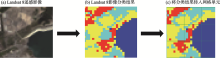
Fig. 1
Grid diagram of land cover/land use data"
Tab. 3
Types of two-factor interaction result"
| 判断依据 | 交互作用类型 |
|---|---|
| q(X1∩X2)<Min[q(X1),q(X2)] | 非线性减弱 |
| Min[q(X1),q(X2)]<q(X1∩X2)<Max[q(X1),q(X2)] | 单因子非线性减弱 |
| q(X1∩X2)>Max[q(X1),q(X2)] | 双因子增强 |
| q(X1∩X2)=q(X1)+q(X2) | 独立 |
| q(X1∩X2)>q(X1)+q(X2) | 非线性增强 |

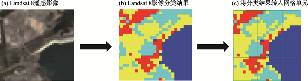
Fig. 2
Land cover/land use distributions of Urumqi City in different periods"

Tab. 4
Characteristics of land use area in Urumqi City in different periods"
| 土地利用类型 | 2000年 | 2010年 | 2020年 | |||
|---|---|---|---|---|---|---|
| 面积/km2 | 比重/% | 面积/km2 | 比重/% | 面积/km2 | 比重/% | |
| 建设用地 | 241.43 | 1.70 | 542.73 | 3.82 | 877.86 | 6.18 |
| 绿地 | 5795.47 | 40.82 | 4818.91 | 33.94 | 5446.31 | 38.36 |
| 裸地 | 7728.13 | 54.43 | 8608.12 | 60.63 | 7568.68 | 53.31 |
| 水体 | 433.13 | 3.05 | 228.40 | 1.61 | 305.31 | 2.15 |
| 总计 | 14198.16 | 100.00 | 14198.16 | 100.00 | 14198.16 | 100.00 |

Fig. 3
Characteristics of dynamic degree and area of different land use types in different periods"
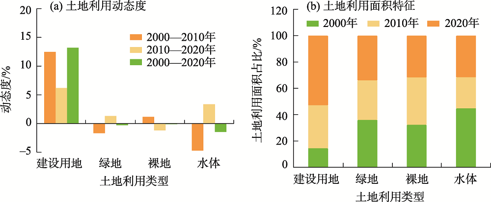
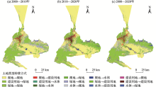
Fig. 4
Transfer matrix of land types in Urumqi City from 2000 to 2020"

Tab. 5
Transfer matrix of land types in Urumqi City from 2000 to 2020"
| 2000年 | 2020年 | ||||
|---|---|---|---|---|---|
| 建设用地 | 裸地 | 绿地 | 水体 | 总计 | |
| 建设用地 | 138.13 | 419.31 | 276.02 | 35.66 | 869.12 |
| 裸地 | 48.75 | 6168.61 | 1249.82 | 99.75 | 7566.93 |
| 绿地 | 38.82 | 1063.89 | 4252.87 | 103.17 | 5458.75 |
| 水体 | 4.37 | 92.32 | 15.51 | 191.16 | 303.36 |
| 总计 | 230.07 | 7744.13 | 5794.22 | 429.74 | 14198.16 |

Fig. 5
Distribution of construction land in Urumqi City in different periods"

Tab. 6
Detection results of interannual factors of land use in Urumqi City"
| 因子 | q值 | ||
|---|---|---|---|
| 2000年 | 2010年 | 2020年 | |
| DEM | 0.30 | 0.14 | 0.29 |
| GDP | 0.11 | 0.07 | 0.10 |
| NDVI | 0.34 | 0.35 | 0.29 |
| 河网密度 | 0.18 | 0.12 | 0.22 |
| 降水量 | 0.10 | 0.09 | 0.11 |
| 坡度 | 0.21 | 0.15 | 0.19 |
| 人口密度 | 0.12 | 0.02 | 0.06 |
| 日照时数 | 0.07 | 0.15 | 0.07 |
| 年平均气温 | 0.08 | 0.09 | 0.08 |

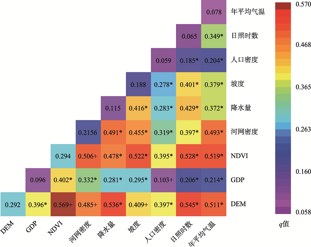
Fig. 6
Interactive detection results of Urumqi City in 2020"
| [1] | 刘亚茹, 王聪, 严力蛟. 华北平原农区土地利用变化对生态系统服务的影响——以河南省商丘市为例[J]. 应用生态学报, 2018, 29(5):1597-1606. |
| [ Liu Yaru, Wang Cong, Yan Lijiao. Impacts of land use change on ecosystem services in the agricultural area of North China Plain: A case study of Shangqiu City, Henan Province, China[J]. Chinese Journal of Applied Ecology, 2018, 29(5):1597-1606. ] | |
| [2] | 刘金勇, 孔繁花, 尹海伟, 等. 济南市土地利用变化及其对生态系统服务价值的影响[J]. 应用生态学报, 2013, 24(5):1231-1236. |
| [ Liu Jinyong, Kong Fanhua, Yin Haiwei, et al. Land use change and its effects on ecosystem service value in Jinan City of Shandong Province, east China[J]. Chinese Journal of Applied Ecology, 2013, 24(5):1231-1236. ] | |
| [3] | Gao J, Li F, Gao H, et al. The impact of land-use change on water-related ecosystem services: A study of the Guishui River Basin, Beijing, China[J]. Journal of Cleaner Production, 2016, 163(Suppl. 1):148-155. |
| [4] |
Shen G, Yang X C, Jin Y X, et al. Land use changes in the Zoige Plateau based on the object-oriented method and their effects on landscape patterns[J]. Remote Sensing, 2019, 12(1):14, doi: 10.3390/rs12010014.
doi: 10.3390/rs12010014 |
| [5] |
Genbatu Ge, Shi Z J, Zhu Y J, et al. Land use/cover classification in an arid desert-oasis mosaic landscape of China using remote sensed imagery: Performance assessment of four machine learning algorithms[J]. Global Ecology and Conservation, 2020, 22, doi: 10.1016/j.gecco.2020.e00971.
doi: 10.1016/j.gecco.2020.e00971 |
| [6] |
Meghan Blumstein, Jonathan R Thompson. Land-use impacts on the quantity and configuration of ecosystem service provisioning in Massachusetts, USA[J]. Journal of Applied Ecology, 2015, 52(4):1009-1019.
doi: 10.1111/1365-2664.12444 |
| [7] | 韩海青, 王旭红, 牛林芝, 等. 1992—2015年中亚五国LUCC特征及耕地驱动力研究[J]. 中国生态农业学报, 2021, 29(2):325-339. |
| [ Han Haiqing, Wang Xuhong, Niu Linzhi, et al. The LUCC characteristics and driving forces of cultivated land in the five Central Asian countries from 1992 to 2015[J]. Chinese Journal of Eco-Agriculture, 2021, 29(2):325-339. ] | |
| [8] | Zhang M Y, Zhang L, Ren X L, et al. Effect of land use and land cover change on the changes in net primary productivity in karst areas of southwest China: A case study of Huanjiang Maonan Autonomous County[J]. Journal of Resources and Ecology, 2020, 11(6):606-616. |
| [9] | 朱增云, 阿里木江·卡斯木. 基于CA-Markov模型的呼图壁县土地利用景观格局预测研究[J]. 生态科学, 2020, 39(1):136-145. |
| [ Zhu Zengyun, Kasimu Alimujiang. Prediction of land use landscape pattern in Hutubi County based on CA-Markov model[J]. Ecological Science, 2020, 39(1):136-145. ] | |
| [10] | 陈磊士, 赵俊三, 李易, 等. 基于机器学习的多源遥感影像融合土地利用分类研究[J]. 西南师范大学学报(自然科学版), 2018, 43(10):103-111. |
| [ Chen Leishi, Zhao Junsan, Li Yi, et al. On land use classification by means of machine learning based on muiti-source remote sensing fusion[J]. Journal of Southwest China Normal University (Natural Science Edition), 2018, 43(10):103-111. ] | |
| [11] | 李平, 吴曼乔, 曾联明. 支持向量机技术在土地利用监测的应用研究[J]. 测绘通报, 2010(8):28-30, 67. |
| [ Li Ping, Wu Manqiao, Zeng Lianming. On application of suport vector machine technology to land use monitoring[J]. Bulletin of Surveying and Mapping, 2010(8):28-30, 67. ] | |
| [12] | 李国庆, 黄菁华, 刘冠, 等. 基于Landsat8卫星影像土地利用景观破碎化研究——以陕西省延安麻塔流域为例[J]. 国土资源遥感, 2020, 32(3):121-128. |
| [ Li Guoqing, Huang Jinghua, Liu Guan, et al. A study of the landscape fragmentations of land cover structure based on Landsat8 remote sensing image: A case study of Mata Watershed in Yan’an, Shaanxi Province[J]. Remote Sensing for Land and Resources, 2020, 32(3):121-128. ] | |
| [13] | 赵海莉, 王启雯, 朱立祥, 等. 基于地理探测器的欠发达地区健康资源时空分异及影响因素研究[J]. 干旱区地理, 2021, 44(2):594-603. |
| [ Zhao Haili, Wang Qiwen, Zhu Lixiang, et al. Analysis of spatial-temporal evolution and influencing factors of health resources in underdeveloped areas based on geodetectors[J]. Arid Land Geography, 2021, 44(2):594-603. | |
| [14] | 郑续, 魏乐民, 郭建军, 等. 基于地理探测器的干旱区内陆河流域产水量驱动力分析——以疏勒河流域为例[J]. 干旱区地理, 2020, 43(6):1477-1485. |
| [ Zheng Xu, Wei Lemin, Guo Jianjun, et al. Driving force analysis of water yield in inland river basins of arid areas based on geo-detectors: A case of the Shule River[J]. Arid Land Geography, 2020, 43(6):1477-1485. ] | |
| [15] | 吕晨, 蓝修婷, 孙威. 地理探测器方法下北京市人口空间格局变化与自然因素的关系研究[J]. 自然资源学报, 2017, 32(8):1385-1397. |
| [ Lü Chen, Lan Xiuting, Sun Wei. A study on the relationship between natural factors and population distribution in Beijing using geographical detector[J]. Journal of Natural Resources, 2017, 32(8):1385-1397. ] | |
| [16] |
王劲峰, 徐成东. 地理探测器: 原理与展望[J]. 地理学报, 2017, 72(1):116-134.
doi: 10.11821/dlxb201701010 |
|
[ Wang Jinfeng, Xu Chengdong. Geodetector: Principle and prospective[J]. Acta Geographica Sinica, 2017, 72(1):116-134. ]
doi: 10.11821/dlxb201701010 |
|
| [17] | 王冬辰, 杜培军, 苏红军, 等. 近20年大同市土地利用/覆盖遥感变化分析[J]. 干旱区资源与环境, 2015, 29(7):68-75. |
| [ Wang Dongchen, Du Peijun, Su Hongjun, et al. Land use/land cover changes in Datong based on remote sensing data[J]. Journal of Arid Land Resources and Environment, 2015, 29(7):68-75. ] | |
| [18] |
Schirpke U, Kohler M, Leitinger G, et al. Future impacts of changing land-use and climate on ecosystem services of mountain grassland and their resilience[J]. Ecosystem Services, 2017, 26:79-94.
doi: 10.1016/j.ecoser.2017.06.008 |
| [19] | 鄂子骥, 阿里木江·卡斯木, 买买提江·买提尼亚孜, 等. 基于网格单元的西北干旱区城市土地覆被/土地利用时空变化研究——以新疆喀什市为例[J]. 干旱区地理, 2018, 41(3):625-633. |
| [ E Ziji, Kasimu Alimiujiang, Maitiniyazi Maimaitijiang, et al. Temporal and spatial variations of urban land cover/land use based on grid element in northwest arid area of China: A case of Kashgar City in Xinjiang[J]. Arid Land Geography, 2018, 41(3):625-633. ] | |
| [20] | 阿里木江•卡斯木, 玉苏普江•艾麦提. 基于ALOS数据的乌鲁木齐市绿地景观格局研究[J]. 地域研究与开发, 2012, 31(2):86-89. |
| [ Kasimu Alimujiang, Aimaitia Yusupujiang. Study on spatial structure of urban greenbelt landscapes in Urumqi City based on ALOS satellite image[J]. Areal Research and Development, 2012, 31(2):86-89. ] | |
| [21] | 哈孜亚·包浪提将, 毋兆鹏, 陈学刚, 等. 乌鲁木齐市景观格局变化及驱动力分析[J]. 生态科学, 2018, 37(1):62-70. |
| [ Baolangtijiang Haziya, Wu Zhaopeng, Chen Xuegang, et al. Analysis of landscape pattern change and driving force in Urumqi City[J]. Ecological Science, 2018, 37(1):62-70. ] | |
| [22] | 赵领娣, 李莎莎, 赵志博, 等. 干旱半干旱区城市生态效率时空演变及区域差异分析[J]. 干旱区地理, 2020, 43(2):449-457. |
| [ Zhao Lingdi, Li Shasha, Zhao Zhibo, et al. Temporal and spatial evolution and regional difference analysis of urban ecological efficiency in arid and semiarid areas[J]. Arid Land Geography, 2020, 43(2):449-457. ] | |
| [23] | 吴志杰, 赵书河. 基于TM图像的“增强的指数型建筑用地指数”研究[J]. 国土资源遥感, 2012, 93(2):50-55. |
| [ Wu Zhijie, Zhao Shuhe. A study of enhanced index-based built-up index based on Landsat TM imagery[J]. Remote Sensing for Land & Resource, 2012, 93(2):50-55. ] | |
| [24] |
Ghulam Abduwasit, Ghulam Oghlan, Maitiniyazi Maimaitijiang, et al. Remote sensing based spatial statistics to document tropical rainforest transition pathways[J]. Remote Sensing, 2015, 7(5):6257-6279.
doi: 10.3390/rs70506257 |
| [25] | 王珊珊, 陈曦, 段含明, 等. 城市地表温度对土地利用/覆被变化响应的遥感研究——以乌鲁木齐为例[J]. 中国沙漠, 2012, 32(3):878-884. |
| [ Wang Shanshan, Chen Xi, Duan Hanming, et al. Study on responsse of land surface temperature to land use and land cover change using remote sensing data: A case on Urumqi, China[J]. Journal of Desert Research, 2012, 32(3):878-884. ] | |
| [26] |
Sexton J O, Urban D L, Donohue M J, et al. Long-term land cover dynamics by multi-temporal classification across the Landsat-5 record[J]. Remote Sensing of Environment, 2013, 128:246-258.
doi: 10.1016/j.rse.2012.10.010 |
| [27] | 赵亚杰, 王立辉, 孔祥兵, 等. 基于Sentinel-2和Landsat 8 OLI数据融合的土地利用分类研究[J]. 福建农林大学学报(自然科学版), 2020, 49(2):248-255. |
| [ Zhao Yajie, Wang Lihui, Kong Xiangbing, et al. Land use classification based on data fusion of Sentinel-2 and Landsat 8 OLI[J]. Journal of Fujian Agriculture and Forestry University (Natural Science Edition), 2020, 49(2):248-255. ] | |
| [28] |
Breiman L. Random forests[J]. Machine Learning, 2001, 45(1):5-32.
doi: 10.1023/A:1010933404324 |
| [29] | 董师师, 黄哲学. 随机森林理论浅析[J]. 集成技术, 2013, 2(1):1-7. |
| [ Dong Shishi, Huang Zhexue. A brief theoretical overview of random forests[J]. Journal of Integration Technology, 2013, 2(1):1-7. ] | |
| [30] | 张卫春, 刘洪斌, 武伟. 基于随机森林和Sentinel-2影像数据的低山丘陵区土地利用分类——以重庆市江津区李市镇为例[J]. 长江流域资源与环境, 2019, 28(6):1334-1343. |
| [ Zhang Weichun, Liu Hongbin, Wu Wei. Classification of land use in low mountain and hilly area based on random forest and Sentinel-2 satellite data: A case study of Lishi Town, Jiangjin, Chongqing[J]. Resources and Environment in the Yangtze Basin, 2019, 28(6):1334-1343. ] | |
| [31] | 谷晓天. 基于机器学习的湟水流域土地利用/土地覆被分类研究[D]. 西宁: 青海师范大学, 2018. |
| [ Gu Xiaotian. Research on land use/land cover classification based on machine learning in the Huangshui River Basin[D]. Xining: Qinghai Normal University, 2018. ] | |
| [32] | 王娜, 李强子, 杜鑫, 等. 单变量特征选择的苏北地区主要农作物遥感识别[J]. 遥感学报, 2017, 21(4):519-530. |
| [ Wang Na, Li Qiangzi, Du Xin, et al. Identification of main crops based on the univariate feature selection in Subei[J]. Journal of Remote Sensing, 2017, 21(4):519-530. ] | |
| [33] | 朱永森, 曾永年, 张猛. 基于HJ卫星数据与面向对象分类的土地利用/覆盖信息提取[J]. 农业工程学报, 2017, 33(14):258-265. |
| [ Zhu Yongsen, Zeng Yongnian, Zhang Meng. Extract of land use/cover information based on HJ satellites data and object-oriented classification[J]. Transactions of the Chinese Society of Agricultural Engineering, 2017, 33(14):258-265. ] | |
| [34] | 买买提江·买提尼亚孜, 阿里木江·卡斯木. 基于网格单元的乌鲁木齐市土地覆被/利用时空变化[J]. 农业工程学报, 2018, 34(1):210-216. |
| [ Maitiniyazi Maimaitijiang, Kasimu Alimujiang. Spatial-temporal change of Urumqi urban land use and land cover based on grid cell approach[J]. Transactions of the Chinese Society of Agricultural Engineering, 2018, 34(1):210-216. ] | |
| [35] | 方创琳. 天山北坡城市群可持续发展战略思路与空间布局[J]. 干旱区地理, 2019, 42(1):1-11. |
| [ Fang Chuanglin. Strategic thinking and spatial layout for the sustainable development of urban agglomeration in northern slope of Tianshan Mountains[J]. Arid Land Geography, 2019, 42(1):1-11. ] | |
| [36] | 杨雅楠, 阿里木江·卡斯木. “一带一路”背景下新疆城镇交通优势度与区域经济发展水平的关系分析[J]. 干旱区地理, 2017, 40(3):680-691. |
| [ Yang Ya’nan, Kasimu Alimujiang. Relationship between regional transportation advantage and development of reginal economy in Xinjiang under the background of the national strategy of the Belt and Road[J]. Arid Land Geography, 2017, 40(3):680-691. ] | |
| [37] | 王雪微, 王士君, 宋飏, 等. 交通要素驱动下的长春市土地利用时空变化[J]. 经济地理, 2015, 35(4):155-161. |
| [ Wang Xuewei, Wang Shijun, Song Yang, et al. Changchun land use spatio-temporal variation under the trasportation elements’ driving[J]. Economic Geography, 2015, 35(4):155-161. ] |
|
||