Arid Land Geography ›› 2022, Vol. 45 ›› Issue (4): 1125-1136.doi: 10.12118/j.issn.1000-6060.2021.510
• Earth Surface Process • Previous Articles Next Articles
HU Feng1( ),ZHANG Yan2,GUO Yu1,ZHANG Panpan1,LYU Shuai1,ZHANG Changchun1()
Received:2021-10-15
Revised:2022-01-22
Online:2022-07-25
Published:2022-08-11
Contact:
Changchun ZHANG
E-mail:1685286505@qq.com;changchun_zhang@hebau.edu.cn
HU Feng,ZHANG Yan,GUO Yu,ZHANG Panpan,LYU Shuai,ZHANG Changchun. Spatial and temporal changes in land use and habitat quality in the Weihe River Basin based on the PLUS and InVEST models and predictions[J].Arid Land Geography, 2022, 45(4): 1125-1136.

Fig. 1
Schematic diagram of Weihe River Basin"

Tab. 1
Data source information table"
| 数据类型 | 数据名称 | 初始数据来源 | |
|---|---|---|---|
| 基础数据 | 行政界限 | 陕甘宁地区省、市级行政边界 | 中国科学院资源环境与数据中心 ( |
| 土地利用数据 | 2000—2020年3期土地利用数据 | ||
| 社会经济统计数据 | 2020年地区生产总值、人口数据统计汇总 | 政府工作报告 | |
| 驱动因子 | 自然环境条件 | 高程 | 中国科学院资源环境与数据中心 ( |
| 坡度 | |||
| 距最近河流距离 | |||
| 年平均降水量 | |||
| 年平均气温 | |||
| 土壤侵蚀程度 | |||
| 社会经济条件 | 地均GDP | 地理国情监测平台 ( | |
| 人口 | |||
| 距最近铁路距离 | |||
| 距最近道路(省道、国道、县道)距离 | |||
| 距最近高速距离 | |||
| 距最近区县中心距离 | |||
| 距最近地市中心距离 | |||
| 距城市建成区距离 | |||
Tab. 2
Realm weight parameters"
| 参数 | 耕地 | 林地 | 草地 | 水域 | 建设用地 | 未利用地 |
|---|---|---|---|---|---|---|
| 领域权重 | 0.00 | 0.66 | 1.00 | 0.68 | 0.96 | 0.69 |
Tab. 3
Transition matrix"
| 土地利用类型 | 耕地 | 林地 | 草地 | 水域 | 建设用地 | 未利用地 |
|---|---|---|---|---|---|---|
| 耕地 | 1 | 1 | 1 | 1 | 1 | 1 |
| 林地 | 1 | 1 | 1 | 0 | 1 | 1 |
| 草地 | 1 | 1 | 1 | 1 | 1 | 1 |
| 水域 | 0 | 0 | 0 | 1 | 0 | 0 |
| 建设用地 | 1 | 1 | 1 | 0 | 1 | 1 |
| 未利用地 | 1 | 1 | 1 | 1 | 1 | 1 |
Tab. 4
Maximum influence distance and weight of stress factor"
| 威胁因子 | 耕地 | 建设用地 | 未利用地 |
|---|---|---|---|
| 最大胁迫距离/km | 4 | 8 | 6 |
| 权重 | 0.6 | 0.4 | 0.5 |
| 空间衰退类型 | 线性 | 指数 | 线性 |
Tab. 5
Sensitivity of land use types to habitat threat factors"
| 土地利用类型 | 生境 适宜度 | 胁迫因子 | ||
|---|---|---|---|---|
| 耕地 | 建设用地 | 未利用地 | ||
| 耕地 | 0.3 | 0.0 | 0.8 | 0.4 |
| 林地 | 1.0 | 0.6 | 0.4 | 0.2 |
| 草地 | 0.9 | 0.8 | 0.6 | 0.6 |
| 水域 | 0.7 | 0.5 | 0.4 | 0.3 |
| 建设用地 | 0.0 | 0.0 | 0.0 | 0.1 |
| 未利用地 | 0.5 | 0.6 | 0.4 | 0.0 |
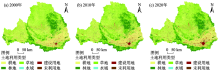
Fig. 2
Spatial distributions of land use in Weihe River Basin from 2000 to 2020"


Fig. 3
Land use area of various types in Weihe River Basin from 2000 to 2020"
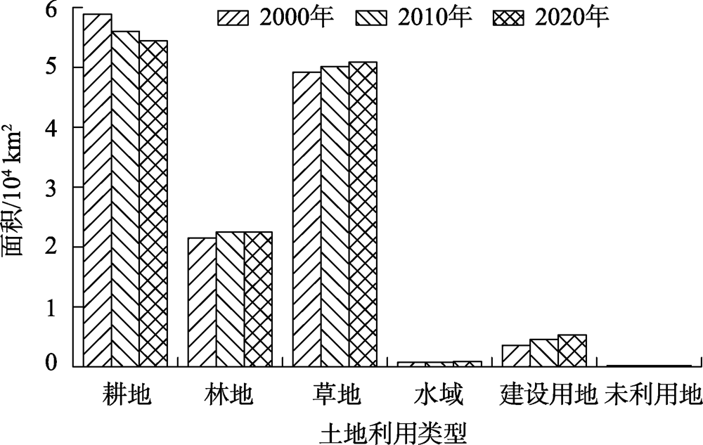
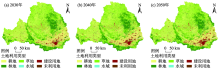
Fig. 4
Spatial distribution prediction of land use in Weihe River Basin from 2030 to 2050"

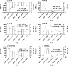
Fig. 5
Area changes of land use types in Weihe River Basin from 2000 to 2050"

Tab. 6
Area and proportion of habitat quality grades in Weihe River Basin from 2000 to 2020"
| 生境 | 2000年 | 2010年 | 2020年 | 2000—2020年 | |||||||
|---|---|---|---|---|---|---|---|---|---|---|---|
| 质量等级 | 面积/km2 | 占比/% | 面积/km2 | 占比/% | 面积/km2 | 占比/% | 面积/km2 | 占比/% | |||
| 低 | 53778.75 | 40.07 | 54387.77 | 40.52 | 55578.46 | 41.41 | 1799.71 | 1.34 | |||
| 较低 | 9079.96 | 6.77 | 6409.66 | 4.78 | 4391.33 | 3.27 | -4688.63 | -3.49 | |||
| 中等 | 833.02 | 0.62 | 846.70 | 0.63 | 884.77 | 0.66 | 51.75 | 0.04 | |||
| 较高 | 49138.88 | 36.61 | 50124.56 | 37.35 | 50924.29 | 37.94 | 1785.41 | 1.33 | |||
| 高 | 21386.36 | 15.93 | 22448.28 | 16.73 | 22438.12 | 16.72 | 1051.76 | 0.78 | |||
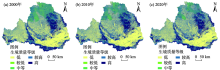
Fig. 6
Spatial distributions of habitat quality in Weihe River Basin from 2000 to 2020"

Fig. 7
Spatial variation of habitat quality in Weihe River Basin from 2000 to 2020"

Tab. 7
Change area and proportion of habitat quality in Weihe River Basin from 2000 to 2020"
| 生境质量 变化情况 | 2000—2010年 | 2010—2020年 | |||
|---|---|---|---|---|---|
| 面积/km2 | 占比/% | 面积/km2 | 占比/% | ||
| 明显改善 | 3814.37 | 2.84 | 8275.41 | 6.17 | |
| 微幅上涨 | 31081.59 | 23.16 | 32676.06 | 24.35 | |
| 保持稳定 | 72401.19 | 53.94 | 69205.00 | 51.56 | |
| 轻微下降 | 24096.28 | 17.95 | 15960.28 | 11.89 | |
| 退化严重 | 2823.54 | 2.10 | 8100.23 | 6.04 | |

Fig. 8
Spatial distribution prediction of habitat quality in Weihe River Basin from 2030 to 2050"
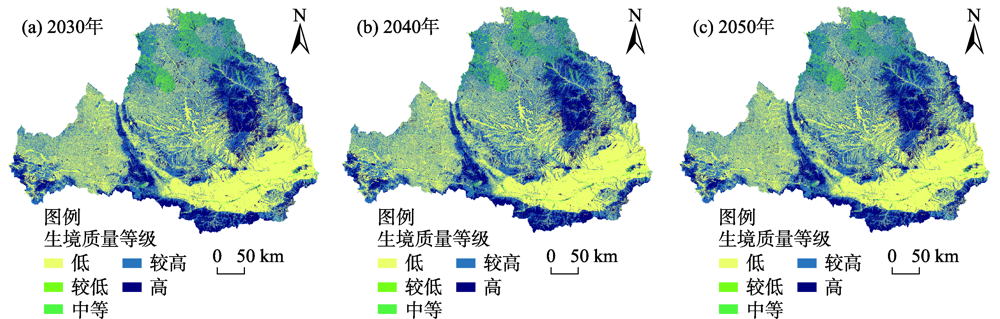

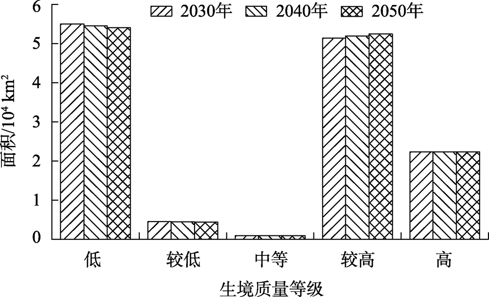
Fig. 9
Habitat quality area of Weihe River Basin from 2030 to 2050"
| [1] | 万炜, 魏伟, 钱大文, 等. 土地利用/覆被变化的环境效应研究进展[J]. 福建农林大学学报(自然科学版), 2017, 46(4): 361-372. |
| [ Wan Wei, Qian Dawen, et al. Progress on the environmental effects of land use and land cover change[J]. Journal of Fujian Agriculture and Forestry University (Natural Science Edition), 2017, 46(4): 361-372. ] | |
| [2] | 李亚丽, 杨粉莉, 杨联安, 等. 近40 a榆林市土地利用空间格局变化及影响因素分析[J]. 干旱区地理, 2021, 44(4): 1011-1021. |
| [ Li Yali, Yang Fenli, Yang Lian’an, et al. Spatial pattern changes and influencing factors of land use in Yulin City in the past 40 years[J]. Arid Land Geography, 2021, 44(4): 1011-1021. ] | |
| [3] | 刘春芳, 王川. 基于土地利用变化的黄土丘陵区生境质量时空演变特征——以榆中县为例[J]. 生态学报, 2018, 38(20): 7300-7311. |
| [ Liu Chunfang, Wang Chuan. Spatio-temporal evolution characteristics of habitat quality in the Loess Hilly Region based on land use change: A case study in Yuzhong County[J]. Acta Ecologica Sinica, 2018, 38(20): 7300-7311. ] | |
| [4] | Hall L S, Krausman P R, Morrison M L. The habitat concept and a plea for standard terminology[J]. Wildlife Society Bulletin, 1997, 25(1): 173-182. |
| [5] | 欧阳志云, 郑华. 生态系统服务的生态学机制研究进展[J]. 生态学报, 2009, 29(11): 6183-6188. |
| [ Ouyang Zhiyun, Zheng Hua. Ecological mechanisms of ecosystem services[J]. Acta Ecologica Sinica, 2009, 29(11): 6183-6188. ] | |
| [6] | 杨志鹏, 许嘉巍, 冯兴华, 等. 基于InVEST模型的东北地区土地利用变化对生境的影响研究[J]. 生态科学, 2018, 37(6): 139-147. |
| [ Yang Zhipeng, Xu Jiawei, Feng Xinghua, et al. Effects of land use change on habitat based on InVEST model in northeast China[J]. Ecological Science, 2018, 37(6): 139-147. ] | |
| [7] | 王军, 严有龙, 王金满, 等. 闽江流域生境质量时空演变特征与预测研究[J]. 生态学报, 2021, 41(14): 5837-5848. |
| [ Wang Jun, Yan Youlong, Wang Jinman, et al. Temporal-spatial variation characteristics and prediction of habitat quality in Min River Basin[J]. Acta Ecologica Sinica, 2021, 41(14): 5837-5848. ] | |
| [8] |
褚琳, 张欣然, 王天巍, 等. 基于CA-Markov和InVEST模型的城市景观格局与生境质量时空演变及预测[J]. 应用生态学报, 2018, 29(12): 4106-4118.
doi: 10.13287/j.1001-9332.201812.013 |
|
[ Chu Lin, Zhang Xinran, Wang Tianwei, et al. Spatial-temporal evolution and prediction of urban landscape pattern and habitat quality based on CA-Markov and InVEST model[J]. Chinese Journal of Applied Ecology, 2018, 29(12): 4106-4118. ]
doi: 10.13287/j.1001-9332.201812.013 |
|
| [9] |
Dessel W V, Rompaey A V, Szilassi P. Sensitivity analysis of logistic regression parameterization for land use and land cover probability estimation[J]. International Journal of Geographical Information Science, 2011, 25(3): 489-508.
doi: 10.1080/13658810903194256 |
| [10] |
Verburg P H, Soepboer W, Veldkamp A, et al. Modeling the spatial dynamics of regional land use: The CLUE-S model[J]. Environmental Management, 2002, 30(3): 391-405.
pmid: 12148073 |
| [11] |
Liu X, Liang X, Li X, et al. A future land use simulation model (FLUS) for simulating multiple land use scenarios by coupling human and natural effects[J]. Landscape and Urban Planning, 2017, 168: 94-116.
doi: 10.1016/j.landurbplan.2017.09.019 |
| [12] |
Liang X, Guan Q, Clarke K C, et al. Understanding the drivers of sustainable land expansion using a patch-generating land use simulation (PLUS) model: A case study in Wuhan, China[J]. Computers, Environment and Urban Systems, Pergamon, 2021, 85: 101569, doi: 10.1016/j.compenvurbsys.2020.101569.
doi: 10.1016/j.compenvurbsys.2020.101569 |
| [13] | 喇蕗梦, 勾蒙蒙, 李乐, 等. 三峡库区生态系统服务权衡时空动态与情景模拟——以秭归县为例[J]. 生态与农村环境学报, 2021, 37(11): 1368-1377. |
| [ La Lumeng, Gou Mengmeng, Li Le, et al. Spatiotemporal dynamics and scenarios analysis on trade-offs between ecosystem service in Three Gorges Reservoir Area: A case study of Zigui County[J]. Journal of Ecology and Rural Environment, 2021, 37(11): 1368-1377. ] | |
| [14] | 李琛, 高彬嫔, 吴映梅, 等. 基于PLUS模型的山区城镇景观生态风险动态模拟[J]. 浙江农林大学学报, 2022, 39(1): 84-94. |
| [ Li Chen, Gao Binpin, Wu Yingmei, et al. Dynamic simulation of landscape ecological risk in mountain towns based on PLUS model[J]. Journal of Zhejiang A & F University, 2022, 39(1): 84-94. ] | |
| [15] |
Li C, Wu Y, Gao B, et al. Multi-scenario simulation of ecosystem service value for optimization of land use in the Sichuan-Yunnan ecological barrier, China[J]. Ecological Indicators, 2021, 132: 108328, doi: 10.1016/j.ecolind.2021.108328.
doi: 10.1016/j.ecolind.2021.108328 |
| [16] | 陆羽, 黄秋昊, 赵琪琪, 等. 基于InVEST与CARS的生态空间分区与未来预测研究[J]. 地理信息世界, 2021, 28(3): 15-19. |
| [ Lu Yu, Huang Qiuhao, Zhao Qiqi, et al. Research on ecological spatial division and future prediction based on InVEST and CARS[J]. Geomatics World, 2021, 28(3): 15-19. ] | |
| [17] |
吴健生, 曹祺文, 石淑芹, 等. 基于土地利用变化的京津冀生境质量时空演变[J]. 应用生态学报, 2015, 26(11): 3457-3466.
pmid: 26915203 |
|
[ Wu Jiansheng, Cao Qiwen, Shi Shuqin, et al. Spatiotemporal variability of habitat quality in Beijing-Tianjin-Hebei area based on land use change[J]. Chinese Journal of Applied Ecology, 2015, 26(11): 3457-3466. ]
pmid: 26915203 |
|
| [18] | 刘孟竹, 张红娟, 王彦芳, 等. 基于土地利用的北方农牧交错带生境质量研究[J]. 水土保持研究, 2021, 28(3): 156-162. |
| [ Liu Mengzhu, Zhang Hongjuan, Wang Yanfang, et al. Characteristics of habitat quality in the agro-pastoral ecotone of northern China based on land uses[J]. Research of Soil and Water Conservation, 2021, 28(3): 156-162. ] | |
| [19] |
Bhagabati N K, Ricketts T, Sulistyawan T B S, et al. Ecosystem services reinforce Sumatran tiger conservation in land use plans[J]. Biological Conservation, 2014, 169: 147-156.
doi: 10.1016/j.biocon.2013.11.010 |
| [20] | 冯舒, 孙然好, 陈利顶. 基于土地利用格局变化的北京市生境质量时空演变研究[J]. 生态学报, 2018, 38(12): 4167-4179. |
| [ Feng Shu, Sun Ranhao, Chen Liding. Spatio-temporal variability of habitat quality based on land use pattern change in Beijing[J]. Acta Ecologica Sinica, 2018, 38(12): 4167-4179. ] | |
| [21] | 黄木易, 岳文泽, 冯少茹, 等. 基于InVEST模型的皖西大别山区生境质量时空演化及景观格局分析[J]. 生态学报, 2020, 40(9): 2895-2906. |
| [ Huang Muyi, Yue Wenze, Feng Shaoru, et al. Spatial-temporal evolution of habitat quality and analysis of landscape patterns in Dabie Mountain area of west Anhui Province based on InVEST model[J]. Acta Ecologica Sinica, 2020, 40(9): 2895-2906. ] | |
| [22] | 冯琰玮, 甄江红, 马晨阳. 呼和浩特市生境质量对城市用地扩展的时空响应[J]. 干旱区地理, 2020, 43(4): 1014-1022. |
| [ Feng Yanwei, Zhen Jianghong, Ma Chenyang. Spatiotemporal response of habitat quality to urban expansion in Hohhot City[J]. Arid Land Geography, 2020, 43(4): 1014-1022. ] | |
| [23] | 庞家泰, 段金亮, 张瑞, 等. 2000—2019年渭河流域植被覆盖度时空演变特征及气候响应[J]. 水土保持研究, 2021, 28(5): 230-237. |
| [ Pang Jiatai, Duan Jinliang, Zhang Rui, et al. Characteristics of spatiotemporal evolution and climate response of vegetation cover in the Wei River Basin from 2000 to 2019[J]. Research of Soil and Water Conservation, 2021, 28(5): 230-237. ] | |
| [24] | 张大川, 刘小平, 姚尧, 等. 基于随机森林CA的东莞市多类土地利用变化模拟[J]. 地理与地理信息科学, 2016, 32(5): 29-36. |
| [ Zhang Dachuan, Liu Xiaoping, et al. Simulating spatiotemporal change of multiple land use types in Dongguan by using random forest based on Cellular Automata[J]. Geography and Geo-Information Science, 2016, 32(5): 29-36. ] | |
| [25] |
陈凯, 刘凯, 柳林, 等. 基于随机森林的元胞自动机城市扩展模拟——以佛山市为例[J]. 地理科学进展, 2015, 34(8): 937-946.
doi: 10.18306/dlkxjz.2015.08.001 |
|
[ Chen Kai, Liu Kai, Liu Lin, et al. Urban expansion simulation by random-forest-based cellular automata: A case study of Foshan City[J]. Progress in Geography, 2015, 34(8): 937-946. ]
doi: 10.18306/dlkxjz.2015.08.001 |
|
| [26] |
王旭, 马伯文, 李丹, 等. 基于FLUS模型的湖北省生态空间多情景模拟预测[J]. 自然资源学报, 2020, 35(1): 230-242.
doi: 10.31497/zrzyxb.20200119 |
|
[ Wang Xu, Ma Bowen, Li Dan, et al. Multi-scenario simulation and prediction of ecological space in Hubei Province based on FLUS model[J]. Journal of Natural Resources, 2020, 35(1): 230-242. ]
doi: 10.31497/zrzyxb.20200119 |
|
| [27] |
Liang X, Liu X P, Li D, et al. Urban growth simulation by incorporating planning policies into a CA-based future land-use simulation model[J]. International Journal of Geographical Information Science, 2018, 32(11): 2294-2316.
doi: 10.1080/13658816.2018.1502441 |
| [28] |
张学儒, 周杰, 李梦梅. 基于土地利用格局重建的区域生境质量时空变化分析[J]. 地理学报, 2020, 75(1): 160-178.
doi: 10.11821/dlxb202001012 |
|
[ Zhang Xueru, Zhou Jie, Li Mengmei. Analysis on spatial and temporal changes of regional habitat quality based on the spatial pattern reconstruction of land use[J]. Acta Geographica Sinica, 2020, 75(1): 160-178. ]
doi: 10.11821/dlxb202001012 |
|
| [29] | 刘春艳, 朱康文, 刘吉平. 三峡库区重庆段土地覆盖和生物多样性功能演化及预测[J]. 农业工程学报, 2017, 33(19): 258-267. |
| [ Liu Chunyan, Zhu Kangwen, Liu Jiping. Evolution and prediction of land cover and biodiversity function in Chongqing section of Three Gorges Reservoir area[J]. Transactions of the Chinese Society of Agricultural Engineering, 2017, 33(19): 258-267. ] | |
| [30] | 许宝荣, 刘一川, 董莹, 等. 基于InVEST模型的兰州地区生境质量评价[J]. 中国沙漠, 2021, 41(5): 120-129. |
| [ Xu Baorong, Liu Yichuan, Dong Ying, et al. Evaluation of habitat quality in Lanzhou region based on InVEST model[J]. Journal of Desert Research, 2021, 41(5): 120-129. ] | |
| [31] | Sharp R, Tallis H T, Ricketts T, et al. InVEST 3.2.0 user’s guide. The natural capital project, stanford university, University of Minnesota, The Nature Conservancy, and World Wildlife Fund[EB/OL]. [2017-10-8]. https://naturalcapitalproject.stanford.edu/software/invest. |
|
||