Arid Land Geography ›› 2026, Vol. 49 ›› Issue (8): 1663-1674.doi: 10.12118/j.issn.1000-6060.2025.762
• Earth Surface Process • Previous Articles Next Articles
LI Sen1,2( ), YU Tengfei1,3(), ZHAO Hongyan4, ZHANG Zhishan1,2, YAN Changzhen1
Received:2025-11-26
Revised:2025-12-31
Online:2026-08-25
Published:2026-08-21
Contact:
YU Tengfei
E-mail:lisen@lzb.ac.cn;yutf@lzb.ac.cn
LI Sen, YU Tengfei, ZHAO Hongyan, ZHANG Zhishan, YAN Changzhen. Spatiotemporal changes of aeolian desertification over the past 50 years and driving force analysis during the reversal period in the central Ningxia arid zone, China[J].Arid Land Geography, 2026, 49(8): 1663-1674.
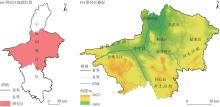
Fig. 1
Schematic diagram of the study area"

Tab. 1
Data sources and processing methods of driving factors"
| 变量类型 | 变量名称 | 空间分辨率 | 时间分辨率 | 年份 | 来源及处理方法 |
|---|---|---|---|---|---|
| 地形因子 | 海拔 | 90 m | - | - | 谷歌地球引擎;在谷歌地球引擎平台直接导出数字高程模型数据,并重采样 |
| 坡度 | 90 m | - | - | 谷歌地球引擎;在谷歌地球引擎平台使用数字高程模型数据计算坡度,并导出 | |
| 坡向 | 90 m | - | - | 谷歌地球引擎;在谷歌地球引擎平台使用数字高程模型数据计算坡向,并导出 | |
| 气候因子 | 干燥度 | 1 km | a | 1990—2020 | 国家地球系统科学数据中心;将网络通用数据格式直接转化获得 |
| 干湿指数 | 1 km | a | 1990—2020 | 国家地球系统科学数据中心;将网络通用数据格式直接转化获得 | |
| 春季风速 | 1 km | a | 1990—2020 | 国家地球系统科学数据中心;采用Python计算3、4、5月风速平均值 | |
| 冬季风速 | 1 km | a | 1990—2020 | 国家地球系统科学数据中心;采用Python计算12、1、2月风速平均值 | |
| 年均风速 | 1 km | a | 1990—2020 | 国家地球系统科学数据中心;采用Python计算1—12月风速平均值 | |
| 起尘风速发生概率 | 0.25° | a | 1990—2020 | 谷歌地球引擎;使用ERA5中3 h风速数据计算每年内3 h风速>4.5 m∙s-1所占的比例,然后样条插值重采样至1 km | |
| 年降水量 | 1 km | a | 1990—2020 | 国家地球系统科学数据中心;采用Python计算1—12月降水总量 | |
| 生长季均温 | 1 km | a | 1990—2020 | 国家地球系统科学数据中心;采用Python计算5—9月生长季平均气温 | |
| 人类活动 | 土地利用 | 30 m | 5 a | 1990—2020 | 课题组自主生产数据,采用面向对象随机森林与目视解译相结合方法,数据精度>90% |
| 人口密度 | 1 km | 5 a | 1990—2020 | 国家地球系统科学数据中心 | |
| 地区生产总值 | 1 km | 5 a | 1992—2020 | 国家地球系统科学数据中心 | |
| 土壤植被 | 植被类型 | 1:1000000 | - | - | 国家青藏高原科学数据中心;将矢量数据直接转为1 km栅格数据 |
| 土壤有机质 | 1:1000000 | - | - | 国家青藏高原科学数据中心;将矢量数据直接转为1 km栅格数据 | |
| 土壤类型 | 1:1000000 | - | - | 国家青藏高原科学数据中心;将矢量数据直接转为1 km栅格数据 | |
| 土壤质地 | 1:1000000 | - | - | 国家青藏高原科学数据中心;将矢量数据直接转为1 km栅格数据 | |
| 黏粒含量 | 1:1000000 | - | - | 国家青藏高原科学数据中心;将矢量数据直接转为1 km栅格数据 | |
| 粉粒含量 | 1:1000000 | - | - | 国家青藏高原科学数据中心;将矢量数据直接转为1 km栅格数据 | |
| 砂粒含量 | 1:1000000 | - | - | 国家青藏高原科学数据中心;将矢量数据直接转为1 km栅格数据 |
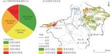
Fig. 2
Area proportion and spatial distribution of aeolian desertification in the central Ningxia arid zone in 2025"

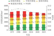
Fig. 3
Changes in the aeolian desertification area and NADI in the central Ningxia arid zone from 1975 to 2025"
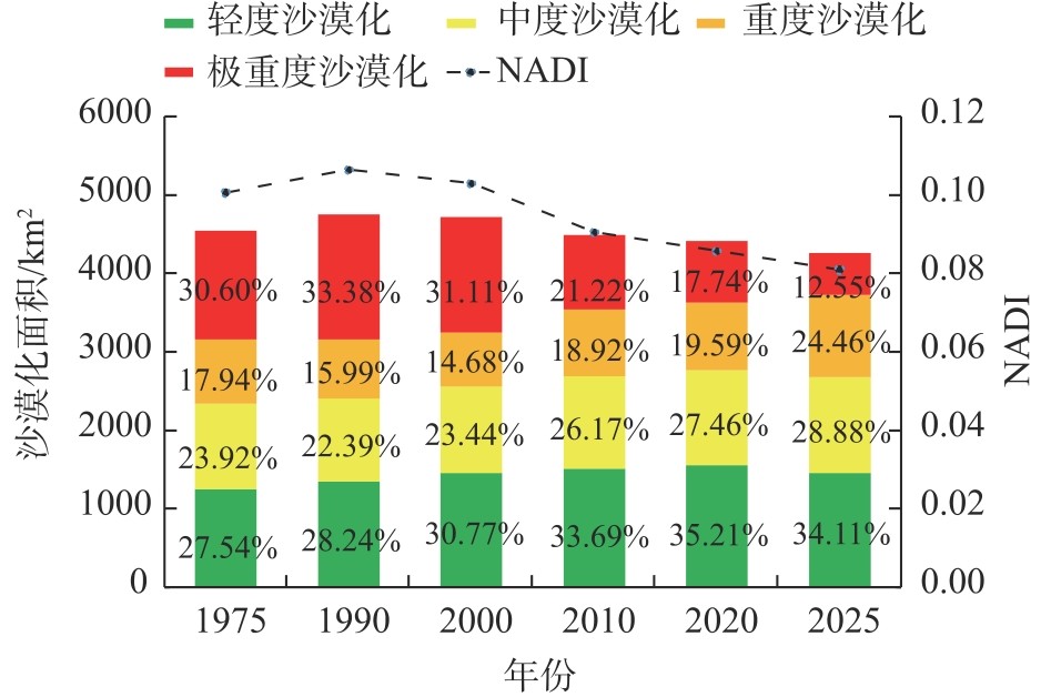
Fig. 4
Sankey diagram of flow directions of different aeolian desertification types in the central Ningxia arid zone from 1975 to 2025"
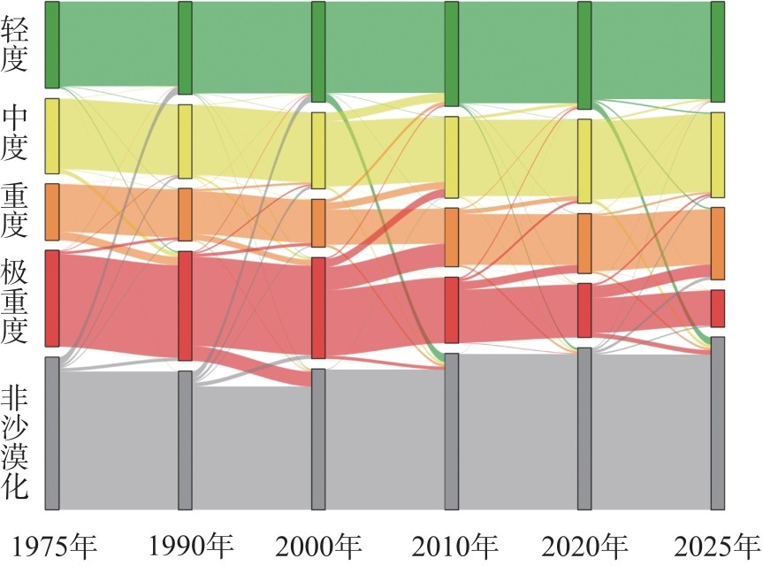
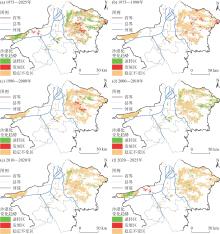
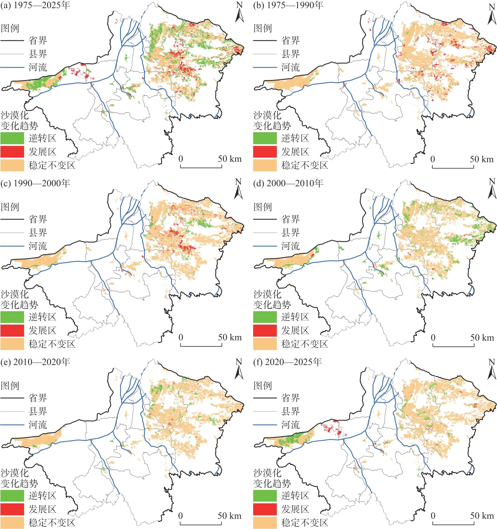
Fig. 5
Spatial distributions of aeolian desertification changes in the central Ningxia arid zone from 1975 to 2025"
Tab. 2
Ranking and q value of the contribution degrees of the driving factors"
| 变量类型 | 变量名称 | 1990年 | 2000年 | 2010年 | 2020年 | |||||||
|---|---|---|---|---|---|---|---|---|---|---|---|---|
| q值 | 排序 | q值 | 排序 | q值 | 排序 | q值 | 排序 | |||||
| 地形因子 | 海拔 | 0.04 | 17 | 0.03 | 18 | 0.03 | 17 | 0.02 | 17 | |||
| 坡度 | 0.01 | 21 | 0.01 | 21 | 0.01 | 21 | 0.01 | 21 | ||||
| 坡向 | 0.02 | 20 | 0.02 | 20 | 0.03 | 18 | 0.03 | 14 | ||||
| 气候因子 | 干燥度 | 0.17 | 1 | 0.08 | 10 | 0.23 | 1 | 0.22 | 2 | |||
| 干湿指数 | 0.14 | 7 | 0.15 | 5 | 0.21 | 4 | 0.22 | 3 | ||||
| 春季风速 | 0.11 | 8 | 0.20 | 1 | 0.20 | 5 | 0.03 | 15 | ||||
| 冬季风速 | 0.16 | 3 | 0.16 | 4 | 0.02 | 19 | 0.01 | 20 | ||||
| 年均风速 | 0.15 | 5 | 0.17 | 3 | 0.22 | 2 | 0.01 | 18 | ||||
| 起尘风速发生概率 | 0.09 | 11 | 0.06 | 14 | 0.11 | 8 | 0.11 | 6 | ||||
| 年降水量 | 0.16 | 4 | 0.10 | 7 | 0.20 | 6 | 0.20 | 4 | ||||
| 生长季均温 | 0.04 | 16 | 0.05 | 17 | 0.03 | 16 | 0.03 | 16 | ||||
| 人类活动 | 土地利用 | 0.15 | 6 | 0.17 | 2 | 0.21 | 3 | 0.17 | 5 | |||
| 人口密度 | 0.09 | 9 | 0.11 | 6 | 0.10 | 9 | 0.32 | 1 | ||||
| 地区生产总值 | 0.17 | 2 | 0.09 | 9 | 0.16 | 7 | 0.05 | 12 | ||||
| 土壤植被 | 植被类型 | 0.03 | 18 | 0.06 | 15 | 0.07 | 13 | 0.08 | 9 | |||
| 土壤有机质 | 0.07 | 13 | 0.08 | 12 | 0.10 | 10 | 0.10 | 7 | ||||
| 土壤类型 | 0.07 | 14 | 0.08 | 11 | 0.07 | 14 | 0.06 | 11 | ||||
| 土壤质地 | 0.03 | 19 | 0.03 | 19 | 0.02 | 20 | 0.01 | 19 | ||||
| 黏粒含量 | 0.05 | 15 | 0.05 | 16 | 0.04 | 15 | 0.03 | 13 | ||||
| 粉粒含量 | 0.08 | 12 | 0.08 | 13 | 0.08 | 12 | 0.07 | 10 | ||||
| 砂粒含量 | 0.09 | 10 | 0.09 | 8 | 0.09 | 11 | 0.08 | 8 | ||||
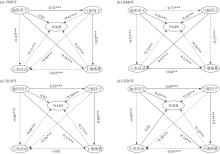
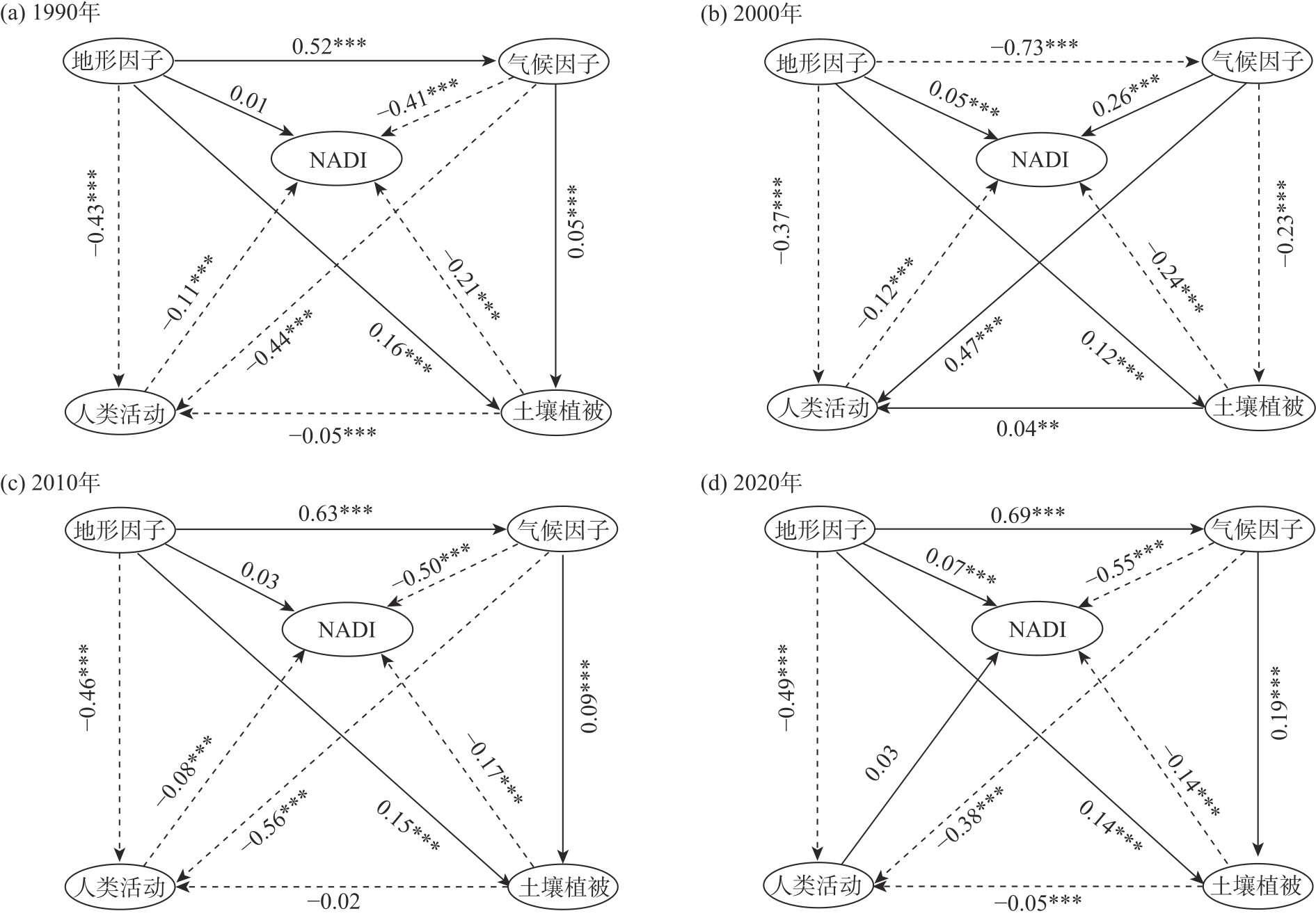
Fig. 6
Relationships of impacts from latent variables on aeolian desertification from 1990 to 2020"
Tab. 3
Direct, indirect and total effects of driving factors on aeolian desertification"
| 年份 | 影响 | 人类活动 | 土壤植被 | 地形因子 | 气候因子 |
|---|---|---|---|---|---|
| 1990 | 直接影响 | -0.11 | -0.21 | 0.23 | -0.45 |
| 间接影响 | - | 0.01 | -0.22 | 0.04 | |
| 总影响 | -0.11 | -0.21 | 0.01 | -0.41 | |
| 2000 | 直接影响 | -0.12 | -0.20 | 0.22 | 0.27 |
| 间接影响 | - | -0.01 | -0.17 | -0.01 | |
| 总影响 | -0.12 | -0.21 | 0.05 | 0.26 | |
| 2010 | 直接影响 | -0.08 | -0.17 | 0.35 | -0.53 |
| 间接影响 | - | 0.00 | -0.33 | 0.03 | |
| 总影响 | -0.08 | -0.17 | 0.03 | -0.50 | |
| 2020 | 直接影响 | 0.03 | -0.14 | 0.46 | -0.51 |
| 间接影响 | - | -0.00 | -0.39 | -0.04 | |
| 总影响 | 0.03 | -0.14 | 0.07 | -0.55 |
| [1] | Wang X M, Geng X, Liu B, et al. Desert ecosystems in China: Past, present, and future[J]. Earth-Science Reviews, 2022, 234: 104206, doi: 10.1016/j.earscirev.2022.104206. |
| [2] | 勿吉斯古冷, 那日苏, 丽娜, 等. 2001—2020年呼伦贝尔草原土地沙漠化敏感性时空格局演化[J]. 干旱区地理, 2025, 58(5): 825-837. |
| [Wujisiguleng, Narisu, Lina, et al. Spatiotemporal pattern evolution of land desertification sensitivity in Hulun Buir grassland from 2001 to 2020[J]. Arid Land Geography, 2025, 58(5): 825-837.] | |
| [3] |
王梅梅, 朱志玲, 吴咏梅. 宁夏中部干旱带土地沙漠化评价[J]. 中国沙漠, 2013, 33(2): 320-324.
doi: 10.7522/j.issn.1000-694X.2013.00045 |
|
[Wang Meimei, Zhu Zhiling, Wu Yongmei. Assessment on the sensitivity to aeolian desertification and importance of controlling aeolian desertification in the middle arid region of Ningxia[J]. Journal of Desert Research, 2013, 33(2): 320-324.]
doi: 10.7522/j.issn.1000-694X.2013.00045 |
|
| [4] |
王新友, 马全林. 近45 a来我国防沙治沙研究主要进展演变及展望——基于CiteSpace的文献可视化分析[J]. 干旱区地理, 2025, 48(2): 234-246.
doi: 10.12118/j.issn.1000-6060.2024.336 |
|
[Wang Xinyou, Ma Quanlin. Citespace-based literature visualization analysis of the hotspots in the research on desertification prevention and control over the last 45 years and its future prospect[J]. Arid Land Geography, 2025, 48(2): 234-246.]
doi: 10.12118/j.issn.1000-6060.2024.336 |
|
| [5] |
李森, 杨宗英, 赵鸿雁, 等. 1975—2020年黄河“几字弯”沙漠化时空变化[J]. 中国沙漠, 2024, 44(5): 13-22.
doi: 10.7522/j.issn.1000-694X.2024.00018 |
|
[Li Sen, Yang Zongying, Zhao Hongyan, et al. Spatio-temporal changes of aeolian desertification in the Jiziwan of the Yellow River from 1975 to 2020[J]. Journal of Desert Research, 2024, 44(5): 13-22.]
doi: 10.7522/j.issn.1000-694X.2024.00018 |
|
| [6] | Jiang Z L, Ni X L, Xing M F. A study on spatial and temporal dynamic changes of desertification in northern China from 2000 to 2020[J]. Remote Sensing, 2023, 15(5): 1368, doi: 10.3390/rs15051368. |
| [7] |
Wang T. Aeolian desertification and its control in northern China[J]. International Soil and Water Conservation Research, 2014, 2(4): 34-41.
doi: 10.1016/S2095-6339(15)30056-3 |
| [8] |
Zhang Z H, Huisingh D. Combating desertification in China: Monitoring, control, management and revegetation[J]. Journal of Cleaner Production, 2018, 182: 765-775.
doi: 10.1016/j.jclepro.2018.01.233 |
| [9] | 王涛. 中国北方沙漠与沙漠化图集[M]. 北京: 科学出版社, 2014: 1-230. |
| [Wang Tao. Atlas of deserts and desertification in northern China[M]. Beijing: Science Press, 2014: 1-230.] | |
| [10] | Ngabire M, Wang T, Xue X, et al. Synergic effects of land-use management systems towards the reclamation of aeolian desertified land in the Shiyang River Basin[J]. Ecological Indicators, 2022, 139: 108882, doi: 10.1016/j.ecolind.2022.108882. |
| [11] |
Xie Z M, Liu Y D, Hu C X, et al. Relationships between the biomass of algal crusts in fields and their compressive strength[J]. Soil Biology and Biochemistry, 2007, 39(2): 567-572.
doi: 10.1016/j.soilbio.2006.09.004 |
| [12] | 鹿化煜. 沙漠演变及沙漠化研究的新趋向[J]. 中国科学: 地球科学, 2025, 55(6): 2089-2093. |
| [Lu Huayu. New trend of studying desert evolution and desertification[J]. Scientia Sinica (Terrae), 2025, 55(6): 2089-2093.] | |
| [13] | Cai D W, Ge Q S, Wang X M, et al. Contributions of ecological programs to vegetation restoration in arid and semiarid China[J]. Environmental Research Letters, 2020, 15(11): 114046, doi: 10.1088/1748-9326/abbde9. |
| [14] | 王训明. 随风而来的沙漠化[J]. 科学通报, 2013, 58(14): 1267-1276. |
|
[Wang Xunming. Desertification driven by wind[J]. Chinese Science Bulletin, 2013, 58(14): 1267-1276.]
doi: 10.1007/s11434-012-5636-7 |
|
| [15] |
王耀宗, 岳新斌, 谢家丽, 等. 2000—2020年宁夏河东沙区沙漠化演变[J]. 中国沙漠, 2023, 43(4): 31-40.
doi: 10.7522/j.issn.1000-694X.2022.00166 |
|
[Wang Yaozong, Yue Xinbin, Xie Jiali, et al. Desertification evolution in the sandy region to the east of the Yellow River in Ningxia from 2000 to 2020[J]. Journal of Desert Research, 2023, 43(4): 31-40.]
doi: 10.7522/j.issn.1000-694X.2022.00166 |
|
| [16] |
赵鸿雁, 颜长珍, 李森, 等. 黄河流域2000—2020年土地沙漠化遥感监测及驱动力分析[J]. 中国沙漠, 2023, 43(3): 127-137.
doi: 10.7522/j.issn.1000-694X.2022.00152 |
|
[Zhao Hongyan, Yan Changzhen, Li Sen, et al. Remote sensing monitoring of aeolian desertification and quantitative analysis of its driving force in the Yellow River Basin during 2000—2020[J]. Journal of Desert Research, 2023, 43(3): 127-137.]
doi: 10.7522/j.issn.1000-694X.2022.00152 |
|
| [17] |
Zhang H, Dong G P, Wang J F, et al. Understanding and extending the geographical detector model under a linear regression framework[J]. International Journal of Geographical Information Science, 2023, 37(11): 2437-2453.
doi: 10.1080/13658816.2023.2266497 |
| [18] | Liu Z J, Si J H, He X H, et al. The impact of desertification on soil health stability in semi-arid alpine regions: A case study of the Qilian Mountains in the northeastern Tibetan Plateau, China[J]. Ecological Indicators, 2024, 163: 112098, doi: 10.1016/j.ecolind.2024.112098. |
| [19] | 武丹, 李欢, 艾宁, 等. 基于CA-Markov的土地利用时空变化与生境质量预测——以宁夏中部干旱区为例[J]. 中国生态农业学报(中英文), 2020, 28(12): 1969-1978. |
| [Wu Dan, Li Huan, Ai Ning, et al. Predicting spatiotemporal changes in land use and habitat quality based on CA-Markov: A case study in central Ningxia, China[J]. Chinese Journal of Eco-Agriculture, 2020, 28(12): 1969-1978.] | |
| [20] | 丛士翔, 丁旭东, 常文静, 等. 宁夏中部干旱带植被净初级生产力对干旱变化的响应[J]. 水土保持通报, 2025, 45(4): 402-412. |
| [Cong Shixiang, Ding Xudong, Chang Wenjing, et al. Response of net primary productivity to drought change in middle arid zone of Ningxia Hui Autonomous Region[J]. Bulletin of Soil and Water Conservation, 2025, 45(4): 402-412.] | |
| [21] |
王劲峰, 徐成东. 地理探测器: 原理与展望[J]. 地理学报, 2017, 72(1): 116-134.
doi: 10.11821/dlxb201701010 |
|
[Wang Jinfeng, Xu Chengdong. Geodetector: Principle and prospective[J]. Acta Geographica Sinica, 2017, 72(1): 116-134.]
doi: 10.11821/dlxb201701010 |
|
| [22] | Gu Z P, Chen X W, Ruan W F, et al. Quantifying the direct and indirect effects of terrain, climate and human activity on the spatial pattern of kNDVI-based vegetation growth: A case study from the Minjiang River Basin, southeast China[J]. Ecological Informatics, 2024, 80: 102493, doi: 10.1016/j.ecoinf.2024.102493. |
| [23] | 高翻翻, 向洋, 王诗媛, 等. 基于地理探测器和PLS-SEM的藏东南植被变化及驱动因子分析[J]. 环境科学与技术, 2024, 47(12): 225-236. |
| [Gao Fanfan, Xiang Yang, Wang Shiyuan, et al. Analysis of vegetation change and driving factors in southeastern Xizang based on geographical detector and PLS-SEM[J]. Environmental Science & Technology, 2024, 47(12): 225-236.] | |
| [24] | Shao W, Li L, Yan M, et al. Thirty years’ spatio-temporal evolution of desertification degrees and driving factors in Turpan-Hami Basin, Xinjiang, China[J]. Ecological Indicators, 2024, 166(4): 112484, doi: 10.1016/j.ecolind.2024.112484. |
| [25] | Zhang C X, Wang X M, Li J C, et al. The impact of climate change on aeolian desertification in northern China: Assessment using aridity index[J]. Catena, 2021, 207: 105681, doi: 10.1016/j.catena.2021.105681. |
| [26] | Wang J F, Wang Y Q, Xu D Y, et al. Desertification in northern China from 2000 to 2020: The spatial-temporal processes and driving mechanisms[J]. Ecological Informatics, 2024, 82: 102769, doi: 10.1016/j.ecoinf.2024.102769. |
| [27] | Zhao H Y, Zhai X H, Li S H, et al. The continuing decrease of sandy desert and sandy land in northern China in the latest 10 years[J]. Ecological Indicators, 2023, 154: 110699, doi: 10.1016/j.ecolind.2023.110699. |
| [28] | Chen P, Wang S, Liu Y X, et al. Spatio-temporal patterns of oasis dynamics in China’s drylands between 1987 and 2017[J]. Environmental Research Letters, 2022, 17(6): 064044, doi: 10.1088/1748-9326/ac740b. |
| [29] | 宋乃平, 汪一鸣, 陈晓芳. 宁夏中部风沙区的环境演变[J]. 干旱区资源与环境, 2004, 18(4): 7-12. |
| [Song Naiping, Wang Yiming, Chen Xiaofang. Environment succession in sandy area of central Ningxia[J]. Journal of Arid Land Resources and Environment, 2004, 18(4): 7-12.] |
|
||

