Arid Land Geography ›› 2025, Vol. 48 ›› Issue (12): 2073-2086.doi: 10.12118/j.issn.1000-6060.2025.236
• Ecology and Environment • Previous Articles Next Articles
DENG Wenbin( ), SONG Sen(), YI Hongmei
Received:2025-04-28
Revised:2025-07-22
Online:2025-12-25
Published:2025-12-30
Contact:
SONG Sen
E-mail:dengwenbin@xju.edu.cn;107552404497@stu.xju.edu.cn
DENG Wenbin, SONG Sen, YI Hongmei. Spatiotemporal dynamics of ecological quality in the Zhundong region based on an arid modified remote sensing ecological index model[J].Arid Land Geography, 2025, 48(12): 2073-2086.
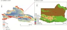
Fig. 1
Overview of the study area"

Tab. 1
Data information and source"
| 数据类型 | 数据名称 | 分辨率 | 来源 |
|---|---|---|---|
| 遥感影像 | Landsat 5 | 30 m | GEE(LANDSAT/LT05/C02/T1_L2) |
| Landsat 8 | 30 m | GEE(LANDSAT/LC08/C02/T1_L2) | |
| 自然数据 | 高程 | 90 m | 地理空间数据云( |
| 坡度 | 90 m | 地理空间数据云( | |
| 坡向 | 90 m | 地理空间数据云( | |
| 气温 | 1 km | NOAA( | |
| 降水 | 1 km | 国家青藏高原科学数据中心( | |
| 蒸散发量 | 1 km | 国家青藏高原科学数据中心( | |
| 经济数据 | 人口密度 | 1 km | LandScan Global数据集( |
| 夜间灯光 | 500 m | 国家地球系统科学数据中心( | |
| 土地利用类型 | 1 km | 中国科学院地理科学与资源研究所( |
Tab. 2
Calculation formula for ARSEI model ecological indicators"
| 遥感参数 | 计算公式 | 参数解释 |
|---|---|---|
| NDVI[ | NDVI为归一化植被指数; | |
| WET[ | WET为湿度指数; | |
| LST[ | LST为地表温度; | |
| MSI[ | MSI为土壤盐渍化指数;MSAVI为修改型土壤调整植被指数;SI为盐分指数;MNI、 | |
| DMI[ | albedo为地表反射率;SFI为土壤肥力指数;DMI为土壤沙化指数;SNI、 | |
| DI[ | DI为PM2.5差值指数 |
Tab. 3
Sen+Mann-Kendall trend classification criteria"
| Z | 趋势特征 | |
|---|---|---|
| 1.96<Z | 显著上升 | |
| Z<1.96 | 不显著上升 | |
| Z | 稳定不变 | |
| Z<1.96 | 不显著下降 | |
| 1.96<Z | 显著下降 |
Tab. 4
Types of Geodetector interactions"
| 判断依据 | 交互作用类型 |
|---|---|
| 非线性减弱 | |
| 单因子非线性减弱 | |
| 双因子增强 | |
| 独立 | |
| 非线性增强 |
Tab. 5
Principal component analysis of ARSEI"
| 年份 | 成分 | 各指标载荷值 | 特征值 | 贡献率/% | |||||
|---|---|---|---|---|---|---|---|---|---|
| NDVI | WET | LST | MSI | DMI | DI | ||||
| 2000 | PC1 | -0.574 | -0.127 | 0.526 | 0.262 | 0.476 | 0.286 | 0.0951 | 87.84 |
| PC2 | -0.374 | 0.061 | -0.824 | 0.224 | 0.163 | 0.316 | 0.0078 | 7.20 | |
| 2005 | PC1 | -0.592 | -0.135 | 0.473 | 0.301 | 0.462 | 0.330 | 0.0992 | 85.18 |
| PC2 | -0.304 | -0.054 | -0.847 | 0.245 | 0.093 | 0.344 | 0.0106 | 9.10 | |
| 2010 | PC1 | -0.623 | -0.164 | 0.475 | 0.316 | 0.379 | 0.339 | 0.1110 | 85.37 |
| PC2 | -0.336 | 0.115 | -0.821 | 0.252 | -0.014 | 0.370 | 0.0102 | 7.88 | |
| 2015 | PC1 | -0.554 | -0.098 | 0.485 | 0.316 | 0.502 | 0.309 | 0.0871 | 84.64 |
| PC2 | -0.335 | -0.026 | -0.833 | 0.301 | 0.044 | 0.317 | 0.0098 | 9.50 | |
| 2018 | PC1 | -0.588 | -0.104 | 0.526 | 0.373 | 0.261 | 0.399 | 0.0743 | 81.83 |
| PC2 | -0.322 | 0.092 | -0.789 | 0.321 | -0.136 | 0.378 | 0.0112 | 12.38 | |
| 2023 | PC1 | -0.575 | -0.159 | 0.493 | 0.355 | 0.374 | 0.367 | 0.0891 | 80.74 |
| PC2 | -0.333 | 0.070 | -0.694 | 0.259 | -0.299 | 0.496 | 0.0120 | 10.79 | |
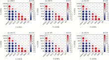
Fig. 2
Correlation analysis results"
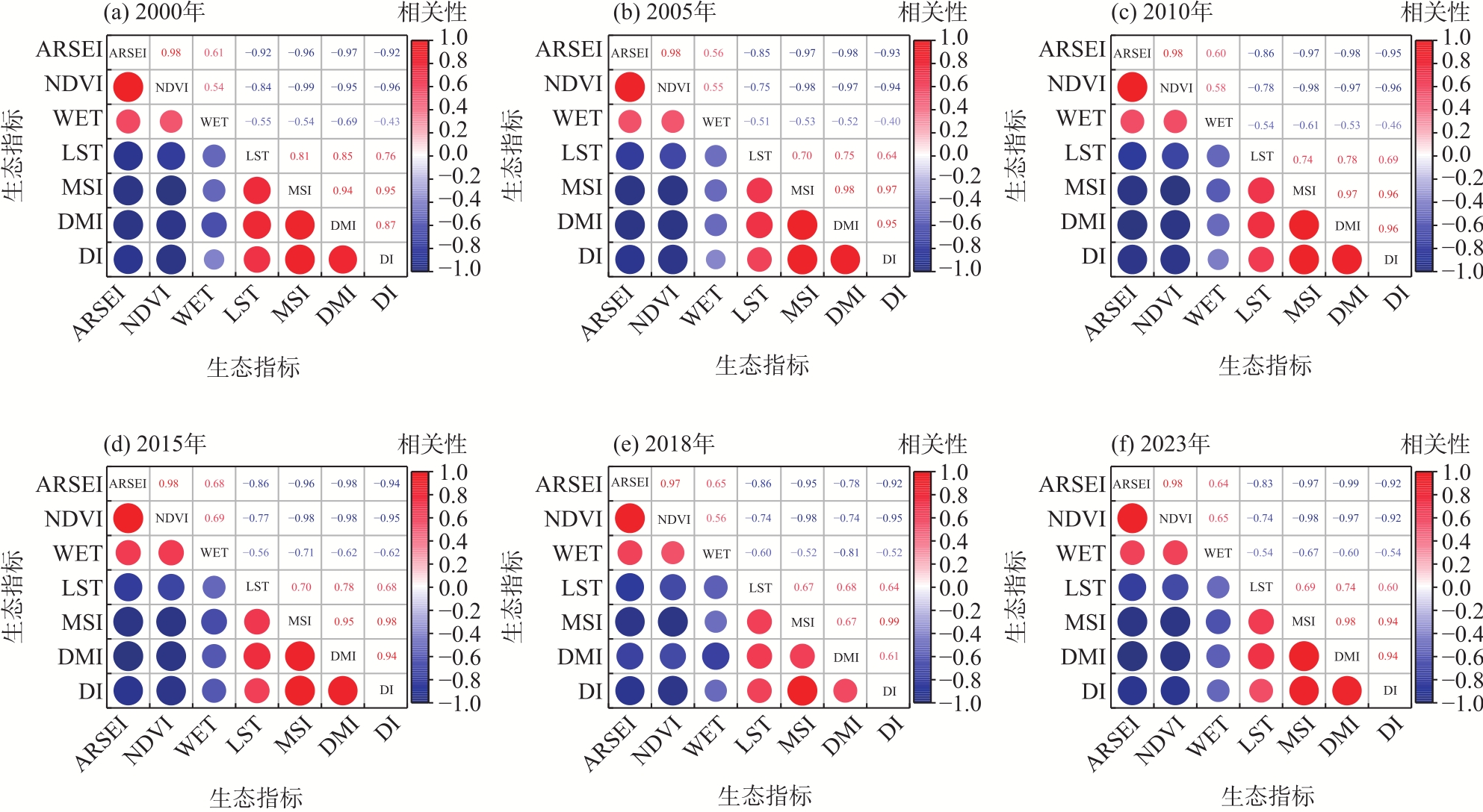
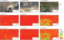
Fig. 3
Comparison of local-scale details in the Zhundong region in 2023"
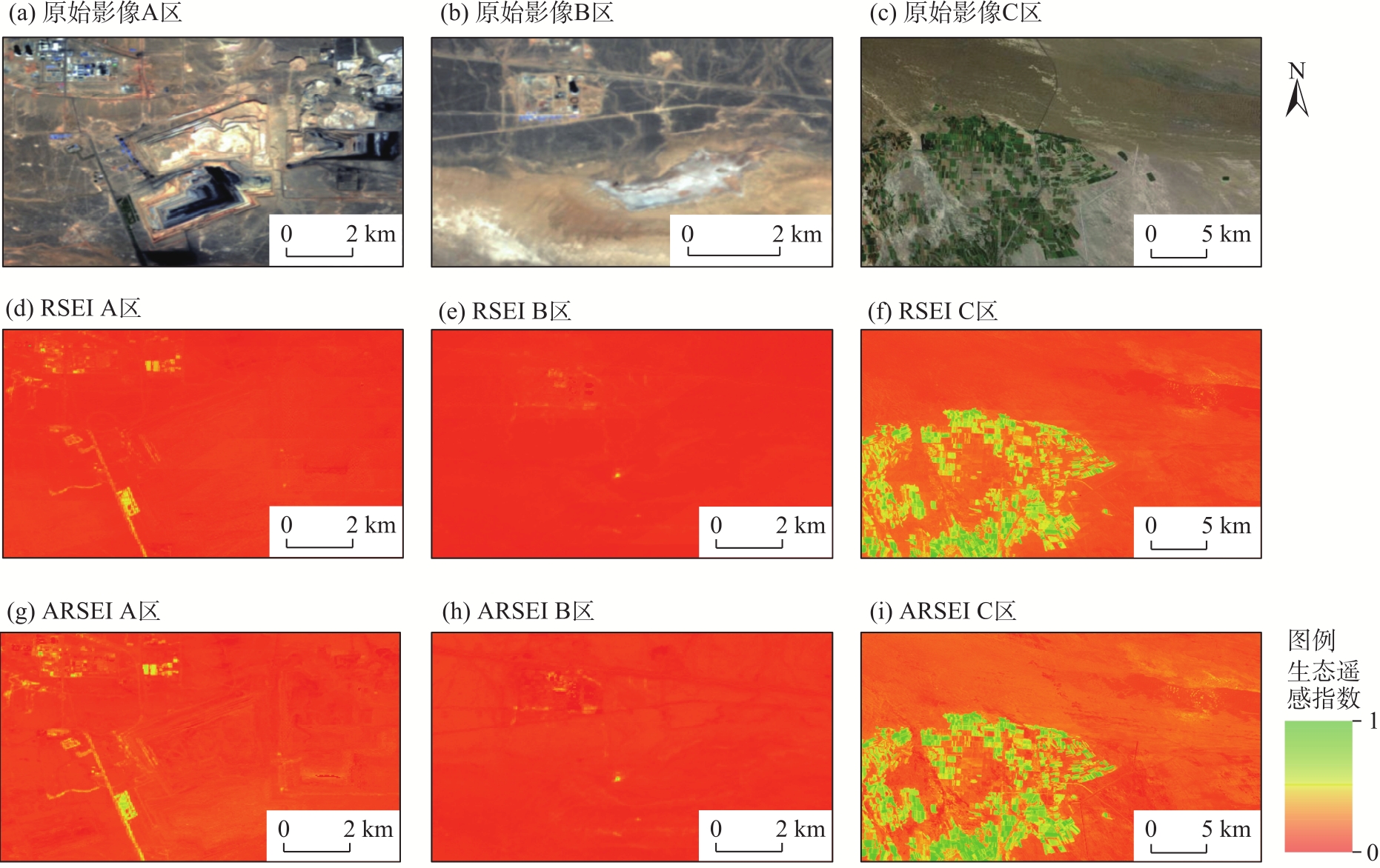
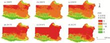
Fig. 4
Spatial distributions of arid modified remote sensing ecological index from 2000 to 2023"

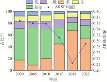
Fig. 5
Composition of ecological environment quality grades"
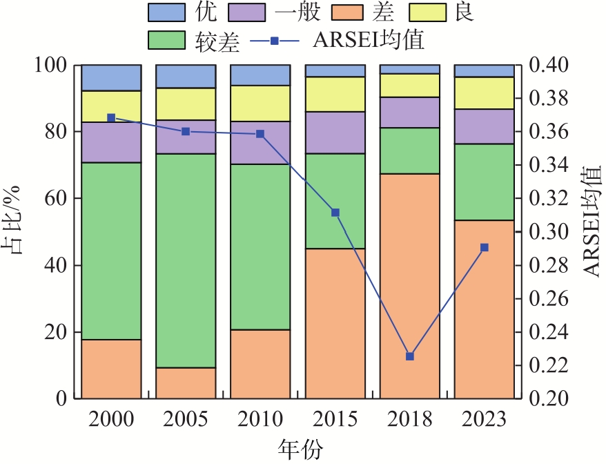
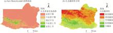
Fig. 6
Trend of ecological changes and distribution of ecological fragility"
Tab. 6
Parameters of human activity impact intensity under different land use types"
| 土地利用类型 | 人类活动影响强度参数 |
|---|---|
| 耕地 | 0.200 |
| 林地 | 0.082 |
| 草地 | 0.067 |
| 水体 | 0.143 |
| 建设用地 | 1.000 |
| 未利用土地 | 0.000 |
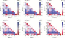
Fig. 7
Interactive detection results of optimal parameters-based geographical detector"

| [1] | Wu G, Tian J, Feng X, et al. Spatiotemporal variation and driving factors of ecological vulnerability in arid and semi-arid regions: A case study of Ningxia, China[J]. Catena, 2025, 259: 109378, doi: 10.1016/j.catena.2025.109378. |
| [2] | 屈楠, 卢杰, 王子明, 等. 毛乌素沙地生态环境质量时空演变及驱动因素[J]. 水土保持通报, 2025, 45(5): 336-346. |
| [Qu Nan, Lu Jie, Wang Ziming, et al. Spatio-temporal evolution and driving factors of ecological environment quality in Mu Us sandy land[J]. Bulletin of Soil and Water Conservation, 2025, 45(5): 336-346.] | |
| [3] | 徐勇, 戴强玉, 黄雯婷, 等. 2000—2020年西南地区植被NDVI时空变化及驱动机制探究[J]. 环境科学, 2023, 44(1): 323-335. |
|
[Xu Yong, Dai Qiangyu, Huang Wenting, et al. Spatio-temporal variation in vegetation cover and its driving mechanism exploration in southwest China from 2000 to 2020[J]. Environmental Science, 2023, 44(1): 323-335.]
doi: 10.1021/es902899n |
|
| [4] | 刘博, 韩庆功, 张杰琳, 等. 变化环境下黄河中游土壤湿度时空格局及其影响因素[J]. 水土保持学报, 2025, 39(1): 73-83. |
|
[Liu Bo, Han Qinggong, Zhang Jielin, et al. Spatial-temporal patterns and factors of soil moisture in the middle reaches of the Yellow River under changing environments[J]. Journal of Soil and Water Conservation, 2025, 39(1): 73-83.]
doi: 10.1080/00224561.1984.12436378 |
|
| [5] | 国家环保总局. 生态环境状况评价技术规范(试行)[EB/OL]. [2006-03-09]. https://www.mee.gov.cn/gkml/zj/gg/200910/t20091021_171618.htm. |
| [State Environmental Protection Agency. Te- chnical criterion for eco-environment status evaluation[EB/OL]. [2006-03-09]. https://www.mee.gov.cn/gkml/zj/gg/200910/t20091021_171618.htm.] | |
| [6] | 徐涵秋. 城市遥感生态指数的创建及其应用[J]. 生态学报, 2013, 33(24): 7853-7862. |
| [Xu Hanqiu. A remote sensing urban ecological index and its application[J]. Acta Ecologica Sinica, 2013, 33(24): 7853-7862.] | |
| [7] | Liu Y, Xu W H, Hong Z H, et al. Integrating three-dimensional greenness into RSEI improved the scientificity of ecological environment quality assessment for forest[J]. Ecological Indicators, 2023, 156: 111092, doi: 10.1016/j.ecolind.2023.111092. |
| [8] | 么廷禹, 王东升, 邰姗姗. 基于遥感生态指数的鞍山市生态环境质量变化研究[J]. 环境科学与技术, 2024, 47(12): 199-210. |
| [Yao Tingyu, Wang Dongsheng, Tai Shanshan. Evaluation of ecological environment quality and analysis of influencing factors in Anshan City based on remote sensing ecological index[J]. Environmental Science & Technology, 2024, 47(12): 199-210.] | |
| [9] |
王杰, 马佳丽, 解斐斐, 等. 干旱地区遥感生态指数的改进——以乌兰布和沙漠为例[J]. 应用生态学报, 2020, 31(11): 3795-3804.
doi: 10.13287/j.1001-9332.202011.011 |
|
[Wang Jie, Ma Jiali, Xie Feifei, et al. Improvement of remote sensing ecological index in arid regions: Taking Ulan Buh Desert as an example[J]. Chinese Journal of Applied Ecology, 2020, 31(11): 3795-3804.]
doi: 10.13287/j.1001-9332.202011.011 |
|
| [10] | 马鹏飞, 张安兵, 王贺封, 等. 基于改进遥感生态指数的矿区生态环境监测及驱动因素分析[J]. 生态与农村环境学报, 2023, 39(12): 1580-1590. |
| [Ma Pengfei, Zhang Anbing, Wang Hefeng, et al. Ecological environment monitoring and driving factors analysis of mining area based on improved remote sensing ecological index[J]. Journal of Ecology and Rural Environment, 2023, 39(12): 1580-1590.] | |
| [11] | 汤从沧, 李巧, 陶洪飞, 等. 基于改进遥感生态指数模型的塔里木河流域生态环境质量评价[J]. 环境科学, 2025, 46(7): 4485-4498. |
| [Tang Congcang, Li Qiao, Tao Hongfei, et al. Evaluating the ecological environment quality in the Tarim River Basin based on the modified remote sensing ecological index model[J]. Environmental Science, 2025, 46(7): 4485-4498.] | |
| [12] | Zhang Y Q, Fang J. Developing a remote sensing-based ecological index based on improved biophysical features[J]. Journal of Applied Remote Sensing, 2022, 16(1): 12008, doi: 10.117/1.JRS.16.012008. |
| [13] | Yu Z H, Jin J, Hou F X, et al. Understanding effect of phosphorus-based additive on ash deposition characteristics during high-sodium and high-calcium Zhundong coal combustion in drop-tube furnace[J]. Fuel, 2021, 287: 119462, doi: 10.1016/j.fuel.2020.119462. |
| [14] | 曾强, 李根生, 董敬宣, 等. 新疆煤炭资源开采典型生态环境问题及对策[J]. 矿业安全与环保, 2017, 44(1): 106-110. |
| [Zeng Qiang, Li Gensheng, Dong Jingxuan, et al. Typical ecological and environmental issues and countermeasures in coal mining in Xinjiang region[J]. Mining Safety and Environmental Protection, 2017, 44(1): 106-110.] | |
| [15] | 张东升, 刘洪林, 范钢伟, 等. 新疆大型煤炭基地科学采矿的内涵与展望[J]. 采矿与安全工程学报, 2015, 32(1): 1-6. |
| [Zhang Dongsheng, Liu Honglin, Fan Gangwei, et al. Connotation and prospection on scientific mining of large Xinjiang coal base[J]. Journal of Mining and Safety Engineering, 2015, 32(1): 1-6.] | |
| [16] | 薛一波, 张小啸, 雷加强, 等. 新疆大气颗粒物污染时空演变及沙尘组分研究[J]. 中国环境科学, 2024, 44(6): 3012-3020. |
| [Xue Yibo, Zhang Xiaoxiao, Lei Jiaqiang, et al. Study on the spatio-temporal variation of atmospheric particulate pollution and its dust components in Xinjiang, northwest China[J]. China Environmental Science, 2024, 44(6): 3012-3020.] | |
| [17] | 赵旭, 李浩, 朱益虎, 等. 融合高分影像与时序NDVI的农作物语义分割模型[J]. 农业工程学报, 2025, 41(14): 216-227. |
| [Zhao Xu, Li Hao, Zhu Yihu, et al. Crop semantic segmentation model integrating high-resolution imagery and time-series NDVI[J]. Transactions of the Chinese Society of Agricultural Engineering, 2025, 41(14): 216-227.] | |
| [18] |
Peng X, Li X, Shen Y Y B, et al. Applicability of different indices for delineating the boundary of arid region: A case study in northwestern China[J]. Journal of Earth Science, 2025, 36(1): 212-222.
doi: 10.1007/s12583-024-0069-1 |
| [19] | Wen X L, Ming Y L, Gao Y G, et al. Dynamic monitoring and analysis of ecological quality of pingtan comprehensive experimental zone, a new type of sea island city, based on RSEI[J]. Sustainability, 2019, 12(1): 21, doi: 10.3390/su12010021. |
| [20] |
李世娇, 张珂珂, 谢宝妮, 等. 基于遥感的库尔勒地区生态环境质量评价及成因分析[J]. 干旱区地理, 2024, 47(12): 2064-2074.
doi: 10.12118/j.issn.1000-6060.2024.250 |
|
[Li Shijiao, Zhang Keke, Xie Baoni, et al. Ecological environment quality evaluation and driving factors of Korla region based on remote sensing[J]. Arid Land Geography, 2024, 47(12): 2064-2074.]
doi: 10.12118/j.issn.1000-6060.2024.250 |
|
| [21] | 冯海英, 冯仲科, 冯海霞. 一种基于差值指数的颗粒物PM2.5浓度反演新方法[J]. 光谱学与光谱分析, 2018, 38(10): 3012-3016. |
| [Feng Haiying, Feng Zhongke, Feng Haixia. One new method of PM2.5 concentration inversion based on difference index[J]. Spectroscopy and Spectral Analysis, 2018, 38(10): 3012-3016.] | |
| [22] | Li N, Wang J Y, Qin F. The improvement of ecological environment index model RSEI[J]. Arabian Journal of Geosciences, 2020, 13(11): 403, doi: 10.1007/s12517-020-05414-7. |
| [23] |
Şen Z, Şişman E. Risk attachment Sen’s slope calculation in hydrometeorological trend analysis[J]. Natural Hazards, 2024, 120(4): 3239-3252.
doi: 10.1007/s11069-023-06329-8 |
| [24] |
王南, 刘泽轩, 郑江华, 等. 天山冰湖分布时空特征及驱动力分析[J]. 干旱区地理, 2024, 47(9): 1472-1481.
doi: 10.12118/j.issn.1000-6060.2023.673 |
|
[Wang Nan, Liu Zexuan, Zheng Jianghua, et al. Spatiotemporal characteristics and driving forces of glacial lakes in Tianshan Mountains[J]. Arid Land Geography, 2024, 47(9): 1472-1481.]
doi: 10.12118/j.issn.1000-6060.2023.673 |
|
| [25] | IPCC Climate change 2014: Impacts, adaptation, and vulnerability. Part A:Global and sectoral aspects. Contribution of working group II to the fifth assessment report of the intergovernmental panel on climate change[M]. Cambridge, UK: Cambridge University Press, 2014. |
| [26] | 王鹤松, 何敏, 闫薇, 等. 基于遥感总初级生产力的天山-塔里木绿洲地区生态系统脆弱性研究[J]. 生态学报, 2021, 41(24): 9729-9737. |
| [Wang Hesong, He Min, Yan Wei, et al. Ecosystem vulnerability in the Tianshan Mountains and Tarim Oasis based on remote sensed gross primary productivity[J]. Acta Ecologica Sinica, 2021, 41(24): 9729-9737.] | |
| [27] |
尤南山, 蒙吉军. 基于生态敏感性和生态系统服务的黑河中游生态功能区划与生态系统管理[J]. 中国沙漠, 2017, 37(1): 186-197.
doi: 10.7522/j.issn.1000-694X.2015.00175 |
|
[You Nanshan, Meng Jijun. Ecological functions regionalization and ecosystem management based on the ecological sensitivity and ecosystem service in the middle reaches of the Heihe River[J]. Journal of Desert Research, 2017, 37(1): 186-197.]
doi: 10.7522/j.issn.1000-694X.2015.00175 |
|
| [28] |
Sun J, Qin X J. Precipitation and temperature regulate the seasonal changes of NDVI across the Tibetan Plateau[J]. Environmental Earth Sciences, 2016, 75: 1-9.
doi: 10.1007/s12665-015-4873-x |
| [29] |
於琍, 曹明奎, 陶波, 等. 基于潜在植被的中国陆地生态系统对气候变化的脆弱性定量评价[J]. 植物生态学报, 2008, 32(3): 521-530.
doi: 10.3773/j.issn.1005-264x.2008.03.001 |
|
[Yu Li, Cao Mingkui, Tao Bo, et al. Quantitative assessment of the vulnerability of terrestrial ecosystems of China to climate change based on potential vegetation[J]. Chinese Journal of Plant Ecology, 2008, 32(3): 521-530.]
doi: 10.3773/j.issn.1005-264x.2008.03.001 |
|
| [30] |
王劲峰, 徐成东. 地理探测器: 原理与展望[J]. 地理学报, 2017, 72(1): 116-134.
doi: 10.11821/dlxb201701010 |
|
[Wang Jinfeng, Xu Chengdong. Geodetector: Principle and prospective[J]. Acta Geographica Sinica, 2017, 72(1): 116-134.]
doi: 10.11821/dlxb201701010 |
|
| [31] |
魏伟, 尹力. 东北地区“三区空间”格局演化特征及驱动机制[J]. 地理科学, 2023, 43(2): 324-336.
doi: 10.13249/j.cnki.sgs.2023.02.014 |
|
[Wei Wei, Yin Li. Evolutionary characteristics and driving mechanisms of the “three-zone space”pattern in northeast China[J]. Scientia Geographica Sinica, 2023, 43(2): 324-336.]
doi: 10.13249/j.cnki.sgs.2023.02.014 |
|
| [32] | 冯东梅, 夏郡, 张步林. 多尺度视角下基于MRSEI的东北地区生态环境质量时空演变及分区管控[J/OL]. 环境科学. [2025-07-22]. https://doi.org/10.13227/j.hjkx.202504177. |
| [Feng Dongmei, Xia Jun, Zhang Bulin. Spatial-temporal evolution and zoning management of ecological environment quality in northeast China based on MRSEI from a multi-scale perspective[J/OL]. Environm-ental Science. [2025-07-22]. https://doi.org/10.13227/j.hjkx.202504177.] | |
| [33] | 卞正富, 于昊辰, 侯竟, 等. 西部重点煤矿区土地退化的影响因素及其评估[J]. 煤炭学报, 2020, 45(1): 338-350. |
| [Bian Zhengfu, Yu Haochen, Hou Jing, et al. Influencing factors and evaluation of land degradation of 12 coal mine areas in western China[J]. Journal of China Coal Society, 2020, 45(1): 338-350.] | |
| [34] | 袁婷婷, 王志强, 汪溪远, 等. 准东红沙泉矿区重金属生态风险缓冲区分析[J]. 土壤通报, 2020, 51(1): 227-233. |
| [Yuan Ting-ting, Wang Zhiqiang, Wang Xiyuan, et al. Buffer analysis of heavy metal ecological risk in the Hongshaquan mining area of east Junggar Basin[J]. Soil Bulletin, 2020, 51(1): 227-233.] | |
| [35] | 刘英, 许萍萍, 毕银丽, 等. 新疆戈壁煤矿露天开采对生态环境扰动定量分析[J]. 煤炭学报, 2023, 48(2): 959-974. |
| [Liu Ying, Xu Pingping, Bi Yinli, et al. Quantitative analysis of coal mining disturbance on environment in Xinjiang Gobi open-pit mining area[J]. Journal of China Coal Society, 2023, 48(2): 959-974.] | |
| [36] | 马丽莎, 郑江华, 彭建, 等. 新疆生态脆弱性特征及其驱动力[J]. 生态学报, 2024, 44(20): 9053-9066. |
| [Ma Lisha, Zheng Jianghua, Peng Jian, et al. Research on the characteristics and driving forces of ecological vulnerability in Xinjiang[J]. Acta Ecologica Sinica, 2024, 44(20): 9053-9066.] | |
| [37] | 于昊辰, 陈浮, 尹登玉, 等. 采矿与气候变化对戈壁矿区土地生态系统的影响——以准东煤炭基地为例[J]. 煤炭学报, 2021, 46(8): 2650-2663. |
| [Yu Haochen, Chen Fu, Yin Dengyu, et al. Effects of mining activities and climate change on land ecosystem in Gobi mining area: A case study of Zhundong coal base[J]. Journal of China Coal Society, 2021, 46(8): 2650-2663.] | |
| [38] | Jiang J, Abulizi A, Abliz A, et al. Construction of landscape ecological security pattern in the Zhundong region, Xinjiang, NW China[J]. International Journal of Environmental Research and Public Health, 2022, 19(10): 6301, doi: 10.3390/ijerph19106301. |
| [39] | Shen L, Zeng Q. Multiscenario simulation of land use and land cover in the Zhundong mining area, Xinjiang, China[J]. Ecological Indicators, 2022, 145: 109608, doi: 10.1016/j.ecolind.2022.109608. |
| [40] |
徐勇, 孙晓一, 汤青. 陆地表层人类活动强度: 概念、方法及应用[J]. 地理学报, 2015, 70(7): 1068-1079.
doi: 10.11821/dlxb201507004 |
|
[Xu Yong, Sun Xiaoyi, Tang Qing. Human activity intensity of land surface: Concept, method and application in China[J]. Acta Geographica Sinica, 2015, 70(7): 1068-1079.]
doi: 10.11821/dlxb201507004 |
|
| [41] | 李怡乐, 张乐艺, 李霞, 等. 基于改进遥感生态指数的粤港澳大湾区生态环境质量监测及驱动力分析[J/OL]. 环境科学. [2025-07-26]. https://doi.org/10.13227/j.hjkx.202504062. |
| [Li Yi-le, Zhang Leyi, Li Xia, et al. Ecological environment monitoring and driving factors analysis of the greater bay area based on improved remote sensing ecological index[J/OL]. Environmental Science. [2025-07-26]. https://doi.org/10.13227/j.hjkx.202504062.] | |
| [42] | 李梦怡, 邓铭江, 凌红波, 等. 新疆绿洲格局变化与生态耗水结构分析[J]. 水科学进展, 2023, 34(5): 719-730. |
| [Li Mengyi, Deng Mingjiang, Ling Hongbo, et al. Analysis on the change of oasis pattern and ecological water consumption structure in Xinjiang[J]. Advances in Water Science, 2023, 34(5): 719-730.] | |
| [43] | 刘芳, 仇韪, 夏楠, 等. 准东南煤炭资源地区土地利用转型及其对生态系统服务价值的影响[J]. 中国煤炭, 2024, 50(9): 144-153. |
| [Liu Fang, Qiu Wei, Xia Nan, et al. Land use transition of coal-based areas in Southeastern Junggar Basin and its impact on ecosystem service value[J]. China Coal, 2024, 50(9): 144-153.] | |
| [44] | 新疆维吾尔自治区发展和改革委员会. 新疆首个开发区生态环境保护条例施行[EB/OL]. [2025-07-29]. https://xjdrc.xinjiang.gov.cn/xjfgw/c108390/201911/ecef101606d946f7b4ce74d7ebc5155a.shtml. |
| [Development and Reform Commission of Xinjiang Uygur Autonomous Region. The first environmental protection regulation for development zones in Xinjiang is implemented[EB/OL]. [2025-07-29]. https://xjdrc.xinjiang.gov.cn/xjfgw/c108390/201911/ecef101606d946f7b4ce74d7ebc5155a.shtml.] | |
| [45] |
张俊杰, 白中科, 杨博宇. 新疆荒漠露天矿区生态受损及砾幕层重构方法研究[J]. 地学前缘, 2021, 28(4): 142-152.
doi: 10.13745/j.esf.sf.2020.10.15 |
|
[Zhang Junjie, Bai Zhongke, Yang Boyu. Gravel curtain layer in the desert open pit mining area of Xinjiang: Ecological damage and reconstruction method[J]. Earth Science Frontiers, 2021, 28(4): 142-152.]
doi: 10.13745/j.esf.sf.2020.10.15 |
|
| [46] | Ou B, Abulizi A, Zayiti A, et al. Ecological risk zoning control in Zhundong economic development zone based on landscape pattern changes[J]. Sustainability, 2023, 15(22): 15972, doi: 10.3390/su152215972. |
|
||