Arid Land Geography ›› 2026, Vol. 49 ›› Issue (4): 778-790.doi: 10.12118/j.issn.1000-6060.2025.292
• Disaster Research • Previous Articles Next Articles
LIU Jinghui( ), LI Xinxu(), YUAN Xushan, LI Yanmin
Received:2025-05-22
Revised:2025-08-20
Online:2026-04-25
Published:2026-04-28
Contact:
LI Xinxu
E-mail:liujh@cidp.edu.cn;lxxmail824@163.com
LIU Jinghui, LI Xinxu, YUAN Xushan, LI Yanmin. Geological disaster risk assessment of Xinyuan County based on entropy weight-random forest optimization weighting method[J].Arid Land Geography, 2026, 49(4): 778-790.

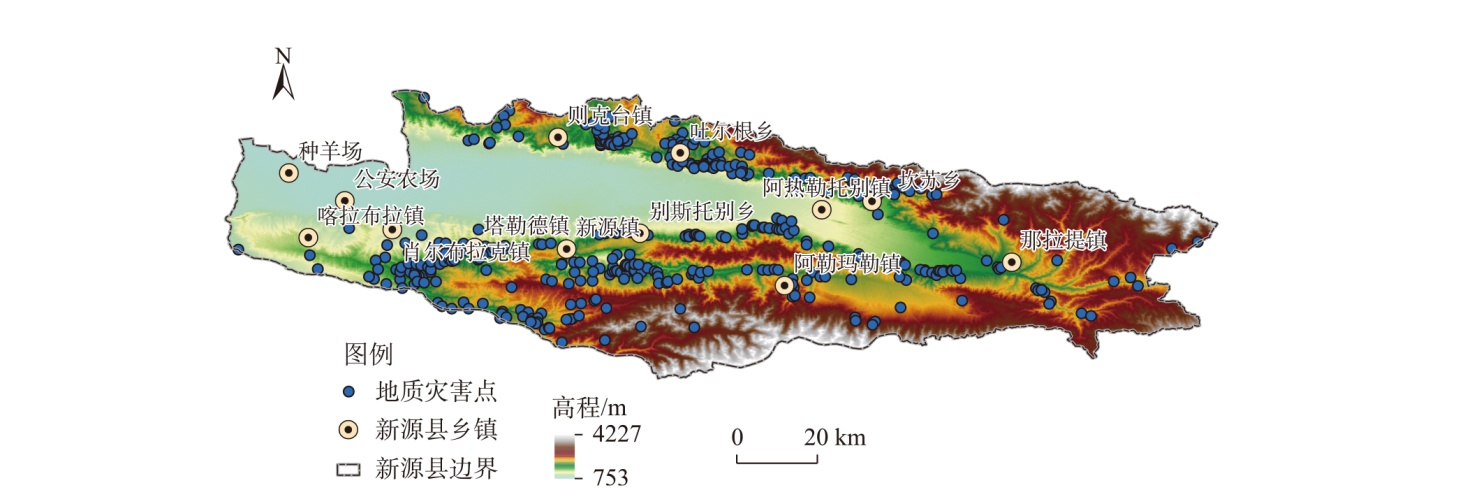
Fig. 1
Schematic diagram of the study area"
Tab. 1
Data source"
| 数据类型 | 数据来源 | 时间分辨率 | 空间分辨率 | 数据说明 |
|---|---|---|---|---|
| 地质灾害点分布数据 | 地理遥感生态网( | 统计至2020年 | 矢量数据 | 导入ArcGIS平台使用 |
| 岩性分布数据 | GLADA数据集( GLADA数据集( GLADA数据集( | 长期不变 长期不变 长期不变 | 1000 m 1000 m 1000 m | 长期稳定且不随时间变化 长期稳定且不随时间变化 长期稳定且不随时间变化 |
| 土壤类型数据 | ||||
| 地貌类型数据 | ||||
| 历史断层分布数据 | 全国地理信息资源目录服务系统( | 统计至2020年 | 矢量数据 | 通过缓存区工具处理为栅格数据使用 |
| 历史干流分布数据 | ||||
| 降雨数据 | 国家青藏高原科学数据中心( | 2020年 | 矢量数据 | 通过克里金插值处理为栅格数据使用 |
| 高程数据 | 地理空间数据云( | 长期不变 | 100 m | 长期稳定且不随时间变化 |
| 植被覆盖数据 | 全球土壤覆盖数据库( | 2020年 | 100 m | - |
| 人口数据 | World Pop官方网站( | 2020年 | 100 m | - |
| GDP数据 | 资源环境科学与数据平台( | 2020年 | 100 m | - |
| 兴趣点数据 | 高德地图( | 2020年 | 矢量数据 | 通过核密度工具处理为兴趣点密度使用 |
| 基础地理数据 | 国家基础地理信息中心( | 2020年 | 矢量数据 | 导入ArcGIS平台使用 |
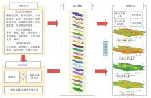
Fig. 2
Flowchart of risk assessment"
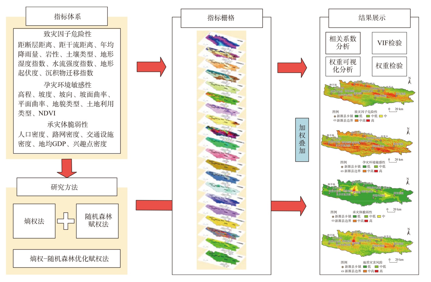
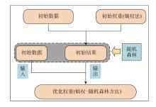
Fig. 3
Flowchart of entropy weight-random forest optimization weighting"

Fig. 4
Multicollinearity test"
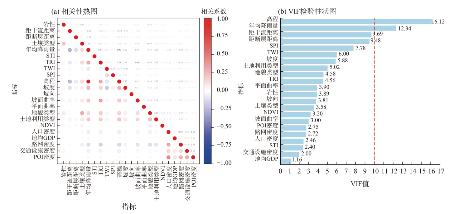

Fig. 5
Grid maps of indicators"
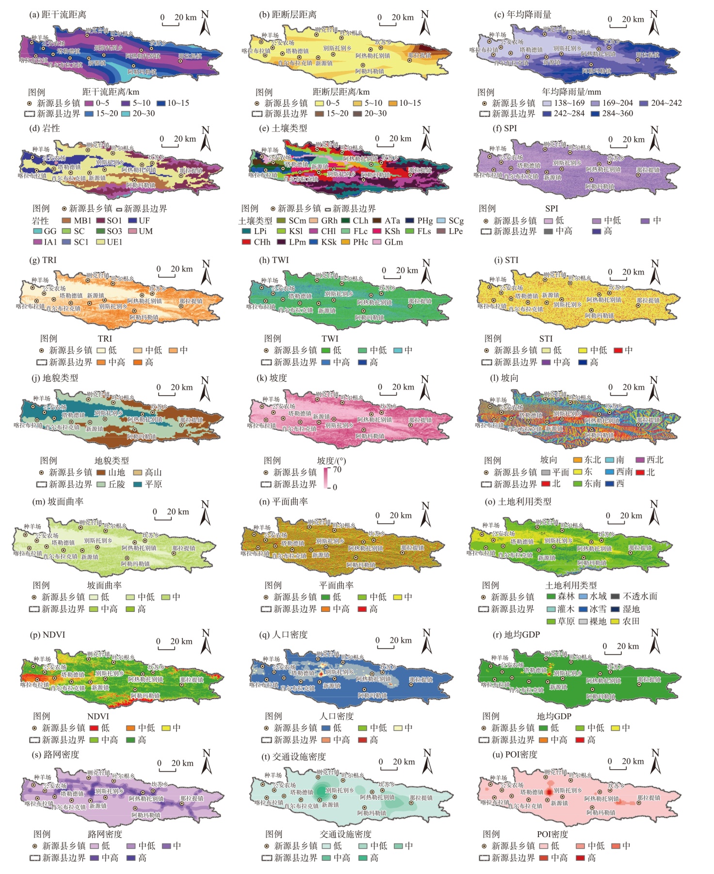
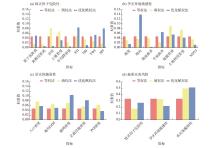
Fig. 6
Comparison of indicator weights"

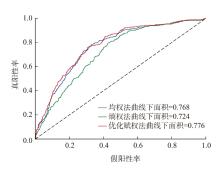
Fig. 7
Receiver operating characteristic curve of different weighting methods"
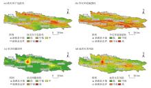
Fig. 8
Map of geological disaster risk and risk components"

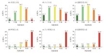
Fig. 9
Validation of risk assessment results"
| [1] | 张策, 揭文辉, 付丽华, 等. 新疆新源县滑坡灾害遥感影像特征及分布规律[J]. 国土资源遥感, 2017, 29(增刊1): 81-84. |
| [Zhang Ce, Jie Wenhui, Fu Lihua, et al. Remote sensing image and distribution characteristics of landslide disasters in Xinyuan County, Xinjiang[J]. Remote Sensing for Land and Resources, 2017, 29(Suppl. 1): 81-84.] | |
| [2] | 史培军. 三论灾害研究的理论与实践[J]. 自然灾害学报, 2002, 11(3): 1-9. |
| [Shi Peijun. Theory on disaster science and disaster dynamics[J]. Journal of Natural Disasters, 2002, 11(3): 1-9.] | |
| [3] | 熊凡, 李沛鸿, 袁逸敏, 等. 基于GIS和组合赋权的城市洪涝灾害风险评估[J]. 人民长江, 2023, 54(8): 60-66. |
| [Xiong Fan, Li Peihong, Yuan Yimin, et al. Urban flood risk assessment based on GIS and combined weights[J]. Yangtze River, 2023, 54(8): 60-66.] | |
| [4] | 郑德凤, 高敏, 李钰, 等. 基于GIS的大连市暴雨洪涝灾害综合风险评估[J]. 河海大学学报(自然科学版), 2022, 50(3): 1-8, 2. |
| [Zheng Defeng, Gao Min, Li Yu, et al. Comprehensive risk assessment of rainstorm-flood disaster in Dalian City based on GIS[J]. Journal of Hohai University (Natural Sciences), 2022, 50(3): 1-8, 2.] | |
| [5] | 费杜秋, 刘峰贵, 周强, 等. 青藏铁路沿线滑坡泥石流灾害风险分析[J]. 干旱区地理, 2016, 39(2): 345-352. |
| [Fei Duqiu, Liu Fenggui, Zhou Qiang, et al. Risk analysis of landslide and debris flow disasters along the Qinghai-Tibet Railway[J]. Arid Land Geography, 2016, 39(2): 345-352.] | |
| [6] | 罗紫元, 田健, 丁锶湲, 等. 基于熵权TOPSIS和神经网络复合方法的厦门市雨洪灾害风险评估[J]. 灾害学, 2022, 37(4): 184-192. |
| [Luo Ziyuan, Tian Jian, Ding Siyuan, et al. Hybrid EWM-TOPSIS and neural network for flood risk evaluation of Xiamen City[J]. Journal of Catastrophology, 2022, 37(4): 184-192.] | |
| [7] | 谢捷, 刘玮, 徐月顺, 等. 基于AHP-熵权法的西宁地区汛期暴雨灾害风险评估[J]. 自然灾害学报, 2022, 31(3): 60-74. |
| [Xie Jie, Liu Wei, Xu Yueshun, et al. Rainstorm disaster risk assessment in Xining area in rainy season based on the AHP weight method and entropy weight method[J]. Journal of Natural Disasters, 2022, 31(3): 60-74.] | |
| [8] | 袁旭山, 刘京会, 宋珂. 基于BP神经网络的洪涝灾害承灾体脆弱性评估[J]. 人民长江, 2024, 55(2): 26-34. |
| [Yuan Xushan, Liu Jinghui, Song Ke. Assessment on vulnerability of flood disaster bearing body based on BP neural network[J]. Yangtze River, 2024, 55(2): 26-34.] | |
| [9] | Al-Abadi A M. Mapping flood susceptibility in an arid region of southern Iraq using ensemble machine learning classifiers: A comparative study[J]. Arabian Journal of Geosciences, 2018, 11(9): 218, doi: 10.1007/s13201-015-0283-1. |
| [10] | 周平华, 李英成, 白洁, 等. 新源县汇水域单元滑坡灾害易发性评价[J]. 测绘科学, 2017, 42(9): 82-87. |
| [Zhou Pinghua, Li Yingcheng, Bai Jie, et al. Susceptibility assessment of landslide hazard to catchment unit in Xinyuan County[J]. Science of Surveying and Mapping, 2017, 42(9): 82-87.] | |
| [11] | 常顺利, 张钟月, 孙志群, 等. 基于GIS的新源县滑坡灾害分析与区划[J]. 自然灾害学报, 2011, 20(5): 216-221. |
| [Chang Shunli, Zhang Zhongyue, Sun Zhiqun, et al. GIS-based analysis and zoning of landslide hazard in Kunes County[J]. Journal of Natural Disasters, 2011, 20(5): 216-221.] | |
| [12] | 程乙峰, 刘志辉. 基于证据权模型的滑坡影响因子研究[J]. 新疆地质, 2016, 34(2): 275-279. |
| [Cheng Yifeng, Liu Zhihui. A research based on weight of evidence model landslide impact factor[J]. Xinjiang Geology, 2016, 34(2): 275-279.] | |
| [13] | 赵忠国, 张峰, 郑江华. 多元自适应回归样条法的滑坡敏感性评价[J]. 武汉大学学报(信息科学版), 2021, 46(3): 442-450. |
| [Zhao Zhongguo, Zhang Feng, Zheng Jianghua. Evaluation of landslide susceptibility by multiple adaptive regression spline method[J]. Geomatics and Information Science of Wuhan University, 2021, 46(3): 442-450.] | |
| [14] | 史培军. 五论灾害系统研究的理论与实践[J]. 自然灾害学报, 2009, 18(5): 1-9. |
| [Shi Peijun. Theory and practice on disaster system research in a fifth time[J]. Journal of Natural Disasters, 2009, 18(5): 1-9.] | |
| [15] | Zhu Y X, Tian D Z, Yan F. Effectiveness of entropy weight method in decision-making[J]. Mathematical Problems in Engineering, 2020(1): 3564835, doi: 10.1155/2020/3564835. |
| [16] | 吴佳瑶, 张煜洲, 陈柯, 等. 基于AHP-熵权法的城市内涝风险评估——以杭州市滨江区为例[J]. 浙江水利水电学院学报, 2024, 36(1): 38-45. |
| [Wu Jiayao, Zhang Yuzhou, Chen Ke, et al. Urban waterlogging risk assessment based on AHP-entropy method: Case study of Binjiang District[J]. Journal of Zhejiang University of Water Resources and Electric Power, 2024, 36(1): 38-45.] | |
| [17] | Bersabe J T, Jun B W. The machine learning-based mapping of urban pluvial flood susceptibility in seoul integrating flood conditioning factors and drainage-related data[J]. ISPRS International Journal of Geo-Information, 2025, 14(2): 57, doi: 10.3390/ijgi14020057. |
| [18] | 郭桂祯, 刘乃山. 基于随机森林模型的区域洪涝灾害房屋倒损评估方法研究[J]. 灾害学, 2018, 33(3): 48-51. |
| [Guo Guizhen, Liu Naishan. A method research of house damage assessment based on random forest model of regional flood disaster[J]. Journal of Catastrophology, 2018, 33(3): 48-51.] | |
| [19] | 郭四代, 袁子寒, 雷高文. 企业碳信息披露质量评价及影响因素研究[J]. 地球环境学报, 2023, 14(6): 848-860. |
| [Guo Sida, Yuan Zihan, Lei Gaowen. Research on quality evaluation and influencing factors of corporate carbon information disclosure[J]. Journal of Earth Environment, 2023, 14(6): 848-860.] | |
| [20] | 刘亚静, 刘红健. 基于信息量-随机森林模型的地震带地质灾害易发性评价: 以松潘-较场地震带为例[J]. 科学技术与工程, 2024, 24(1): 143-154. |
| [Liu Yajing, Liu Hongjian. Evaluation of geological hazard susceptibility in seismic zone based on information data-RF model: A case study of Songpan-Jiaochang seismic zone[J]. Science Technology and Engineering, 2024, 24(1): 143-154.] | |
| [21] | 马红娜, 刘江, 冯卫, 等. 地质灾害风险评估在国土空间规划中的应用——以陕北榆林高西沟为例[J]. 西北地质, 2023, 56(3): 223-231. |
| [Ma Hongna, Liu Jiang, Feng Wei, et al. Application of geological hazard risk assessment in territorial space planning: A case study of Gaoxigou Village in Yulin City of northern Shaanxi Province[J]. Northwestern Geology, 2023, 56(3): 223-231.] | |
| [22] |
Alin A. Multicollinearity[J]. Wiley Interdisciplinary Reviews: Computational Statistics, 2010, 2(3): 370-374.
doi: 10.1002/wics.v2:3 |
| [23] | 张向宁, 王小军, 齐广平, 等. 基于DPSR-信息敏感性的水安全评价指标体系构建——以庆阳市为例[J]. 干旱区资源与环境, 2022, 36(9): 44-53. |
| [Zhang Xiangning, Wang Xiaojun, Qi Guangping, et al. Construction of water security evaluating index system based on driving force-pressure-state-response model and information sensitivity[J]. Journal of Arid Land Resources and Environment, 2022, 36(9): 44-53.] | |
| [24] | Strobl C, Boulesteix A L, Kneib T, et al. Conditional variable importance for random forests[J]. BMC Bioinformatics, 2008, 9(1): 307, doi: 10.1186/1471-2105-9-307. |
| [25] | 袁旭山, 刘京会, 黄龙生, 等. 基于机器学习模型的新源县滑坡易发性评估[J]. 科学技术与工程, 2025, 25(5): 1815-1826. |
| [Yuan Xushan, Liu Jinghui, Huang Longsheng, et al. Assessment of landslide susceptibility in Xinyuan County based on machine learning models[J]. Science Technology and Engineering, 2025, 25(5): 1815-1826.] | |
| [26] |
梁世川, 乔华, 吕东, 等. 伊犁谷地地质灾害分布特征及主控因素分析[J]. 干旱区地理, 2023, 46(6): 880-888.
doi: 10.12118/j.issn.1000-6060.2022.458 |
|
[Liang Shichuan, Qiao Hua, Lü Dong, et al. Distribution characteristics and main controlling factors of geohazards in Ili Valley[J]. Arid Land Geography, 2023, 46(6): 880-888.]
doi: 10.12118/j.issn.1000-6060.2022.458 |
|
| [27] |
陈世泷, 孟庆凯, 戴勇, 等. 基于CMIP6未来情景的伊犁河流域地质灾害危险性评估预测[J]. 干旱区地理, 2025, 48(4): 599-611.
doi: 10.12118/j.issn.1000-6060.2024.520 |
|
[Chen Shilong, Meng Qingkai, Dai Yong, et al. Geological disaster hazard assessment and prediction in the Ili River Basin based on CMIP6 future scenarios[J]. Arid Land Geography, 2025, 48(4): 599-611.]
doi: 10.12118/j.issn.1000-6060.2024.520 |
|
| [28] | Bastos M C, Thieken A H. Urban growth and spatial segregation increase disaster risk: Lessons learned from the 2023 disaster on the north coast of São Paulo, Brazil[J]. Natural Hazards and Earth System Sciences, 2024, 24(9): 3299-3314. |
| [29] | Mosaffaie J, Salehpour Jam A, Sarfaraz F. Landslide risk assessment based on susceptibility and vulnerability[J]. Environment, Development & Sustainability, 2024, 26(4): 9285-9303. |
| [1] | BAO Yubin, ZHANG Huijuan, YANG Xueru, WANG Yaozong, LI Qiaomin, WANG Ke, HU Sheng. Spatiotemporal variation and potential zoning diagnosis of ecosystem carbon sinks in Ningxia [J]. Arid Land Geography, 2026, 49(4): 740-755. |
| [2] | ZHANG Yiming, TANG Yulei, FENG Junbo. Predicting and analysing glaciers in the Qinghai-Xizang Plateau: A random forest model [J]. Arid Land Geography, 2025, 48(8): 1342-1352. |
| [3] | CHEN Shilong, MENG Qingkai, DAI Yong, YANG Liqiang, WU Han. Geological disaster hazard assessment and prediction in the Ili River Basin based on CMIP6 future scenarios [J]. Arid Land Geography, 2025, 48(4): 599-611. |
| [4] | LIN Mofei, GUAN Yawen, LIAN Yifei. Ecological vulnerability assessment of Tarim Populus euphratica Forest Park based on SRP model [J]. Arid Land Geography, 2025, 48(11): 2019-2030. |
| [5] | LI Ke, HE Jing, MENG Yangyang, LI Changrui. Spatial distribution and influencing factors of key rural tourism villages in the Yellow River Basin [J]. Arid Land Geography, 2025, 48(11): 2031-2041. |
| [6] | MA Xiaomin, ZHANG Zhibin, GUO Qianqian, ZHAO Xuewei, ZHANG Ning. Spatial and temporal evolution and driving factors of population in Lanzhou City from 2000 to 2020 [J]. Arid Land Geography, 2025, 48(1): 168-178. |
| [7] | ZHAO Guobing, ZHENG Jianghua, WANG Lei, GAO Jian, LUO Lei, Nigela TUERXUN, HAN Wanqiang, GUAN Jingyun. Remote sensing extraction of jujube planting area in Xinjiang based on RF classification optimization and SNIC clustering [J]. Arid Land Geography, 2024, 47(6): 1004-1014. |
| [8] | WANG Dai, CUI Yang, WANG Suyan, ZHANG Wen. Interdecadal changes and risk assessment of drought events in Ningxia from 1961 to 2020 [J]. Arid Land Geography, 2024, 47(5): 785-797. |
| [9] | WANG Anqi, ZHANG Yu, LIU Jiawei, ZHAO Wei, LIU Xinyu, LI Kai. Vegetation community diversity and spatial distribution pattern in Ganjiahu Saxoul National Nature Reserve, Xinjiang [J]. Arid Land Geography, 2024, 47(11): 1841-1851. |
| [10] | CHEN Man, CHEN Yaning, FANG Gonghuan, LI Yupeng, SUN Huilan. Changes in glacial lakes on the northern slope of Kunlun Mountains and assessment of their outburst risks [J]. Arid Land Geography, 2024, 47(10): 1628-1639. |
| [11] | SHI Weiliang, CHE Luyang, LI Tao. Probability distribution and comprehensive risk assessment of extreme precipitation in flood season in Shaanxi Province [J]. Arid Land Geography, 2023, 46(9): 1407-1417. |
| [12] | LI Lele, CHAO Jinlong, ZHAO Deyi, LI Haojie, WU Lindong, LI Jiajun. Spatiotemporal distribution characteristics of rainstorm and risk assessment of rainstorm disasters in Shanxi Province from 1957 to 2019 [J]. Arid Land Geography, 2023, 46(5): 689-699. |
| [13] | WU Yingying,WANG Zhenting. Risk assessment of soil wind erosion in Hetao Plain [J]. Arid Land Geography, 2023, 46(3): 418-427. |
| [14] | ZHANG Juan, YAO Xiaojun, LI Jing, WANG Xiaoyan. Agricultural drought research based on multi-source remote sensing data in Gansu Province [J]. Arid Land Geography, 2023, 46(1): 11-22. |
| [15] | Mihray MOYIDIN, Mamat SAWUT, LI Jinzhao. Extraction of cotton planting area based on Sentinel-2 time series data and phenological characteristics [J]. Arid Land Geography, 2022, 45(6): 1847-1859. |
|
||