- May. 13, 2025
Arid Land Geography ›› 2025, Vol. 48 ›› Issue (4): 599-611.doi: 10.12118/j.issn.1000-6060.2024.520
• The Third Xinjiang Scientific Expedition • Previous Articles Next Articles
CHEN Shilong1,2( ), MENG Qingkai1(), DAI Yong1,3, YANG Liqiang4, WU Han1
Received:2024-09-02
Revised:2024-09-23
Online:2025-04-25
Published:2025-04-18
Contact:
MENG Qingkai
E-mail:slslug@163.com;mengqingkai@imde.ac.cn
CHEN Shilong, MENG Qingkai, DAI Yong, YANG Liqiang, WU Han. Geological disaster hazard assessment and prediction in the Ili River Basin based on CMIP6 future scenarios[J].Arid Land Geography, 2025, 48(4): 599-611.
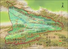
Fig. 1
Schematic diagram of the study area"

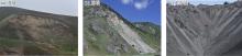
Fig. 2
Field investigation of geological disasters in the Ili River Basin"

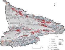
Fig. 3
Distribution of geological disasters in the Ili River Basin"

Tab. 1
Data sources of hazard evaluation indicators"
| 数据内容 | 评价指标 | 数据来源 |
|---|---|---|
| 数字高程模型数据 | 坡度 | https://www.gscloud.cn |
| 坡向 | https://www.gscloud.cn | |
| 高程 | https://www.gscloud.cn | |
| 曲率 | https://www.gscloud.cn | |
| 距河流距离 | https://www.gscloud.cn | |
| 土地利用类型数据 | 土地利用类型 | http://www.globallandcover.com |
| 工程地质岩组数据 | 工程地质岩组 | http://www.ngac.org.cn/ddzt/index1.html |
| 断层数据 | 距断层距离 | http://www.ngac.org.cn/ddzt/index1.html |
| 地震峰值加速度数据 | PGA | https://zenodo.org |
| 气候数据 | 降水量 | https://worldclim.org |
| 气温 | https://worldclim.org |
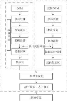
Fig. 4
Division flowchart of evaluation unit"


Fig. 5
Technical flowchart"
Tab. 2
Information amount of assessment factors"
| 评价因子 | 分区 | 崩滑信息量 | 泥石流信息量 | 评价因子 | 分区 | 崩滑信息量 | 泥石流信息量 |
|---|---|---|---|---|---|---|---|
| 坡度/(°) | <5 | -1.523 | -1.511 | 距断层距离/m | <1000 | 0.685 | -0.887 |
| 5~15 | 0.008 | -0.924 | 1000~2000 | 0.102 | -0.751 | ||
| 15~25 | 0.887 | 0.067 | 2000~5000 | -0.068 | 0.035 | ||
| 25~40 | 0.285 | 0.670 | 5000~10000 | 0.158 | 0.338 | ||
| >40 | -0.687 | 1.363 | >10000 | -1.271 | 0.089 | ||
| 坡向/(°) | 北 | 0.013 | -0.661 | 工程地质岩组 | 坚硬中-厚层状碳酸盐岩组 | -0.945 | 0.591 |
| 东北 | 0.425 | 0.600 | |||||
| 东 | 0.327 | 0.357 | 坚硬块状花岗岩岩组 | -0.316 | 0.765 | ||
| 东南 | -0.249 | 0.252 | |||||
| 南 | -0.907 | -0.009 | 第四系冲洪积、风积、 冰积黄土 | 0.867 | -1.987 | ||
| 西南 | -0.267 | -0.256 | |||||
| 西 | 0.325 | 0.036 | |||||
| 西北 | 0.037 | -0.292 | 互层状较软砂岩、砾岩为主的 碎屑岩岩组 | 0.584 | 0.159 | ||
| 高程/m | <1000 | -3.569 | -5.539 | ||||
| 1000~1500 | 0.422 | -1.637 | |||||
| 1500~2000 | 0.873 | -1.527 | 坚硬、较坚硬砂岩为主的 碎屑岩岩组 | 0.756 | -1.208 | ||
| 2000~3000 | -0.463 | 0.238 | |||||
| >3000 | -0.526 | 1.289 | |||||
| 曲率 | <-1.00 | -0.157 | 0.372 | PGA/g | <0.2 | -1.420 | -0.644 |
| -1.00~-0.35 | -0.274 | -0.612 | 0.2~0.25 | 0.010 | 0.319 | ||
| -0.35~0.35 | -0.671 | -0.737 | 0.25~0.3 | 0.446 | -0.552 | ||
| 0.35~1.00 | 0.803 | 0.558 | 0.3~0.4 | -0.300 | 0.104 | ||
| >1.00 | 0.054 | 0.211 | >0.4 | 0.000 | 0.000 | ||
| 土地利用类型 | 裸地 | -0.482 | 0.988 | 气温/℃ | <-4 | -0.443 | 1.281 |
| 农作物 | -2.359 | -6.898 | -4~0 | -0.553 | -0.531 | ||
| 建筑用地 | -3.305 | 0.000 | 0~4 | 0.822 | -1.615 | ||
| 灌木林地 | 0.347 | -0.097 | 4~8 | -0.132 | -2.003 | ||
| 其他 | -1.424 | 0.762 | >8 | -6.175 | -5.112 | ||
| 距河流距离/m | <200 | 0.020 | 1.044 | 降水量/mm | <250 | -0.043 | -3.174 |
| 200~500 | 0.392 | 1.281 | 250~350 | 0.227 | -0.956 | ||
| 500~1000 | 0.481 | -0.086 | 350~450 | -0.359 | 0.987 | ||
| 1000~2000 | -0.011 | -1.597 | 450~550 | -1.053 | 1.197 | ||
| >2000 | -0.790 | -3.225 | >550 | -0.465 | 0.502 |
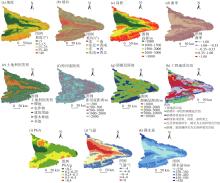
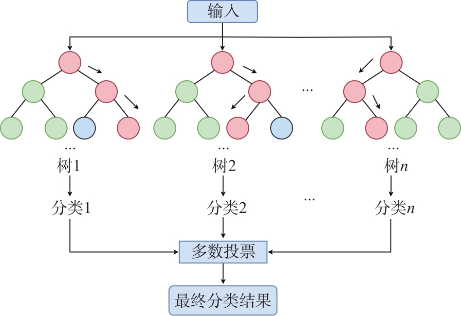
Fig. 6
Zonation maps of hazard assessment indicators"
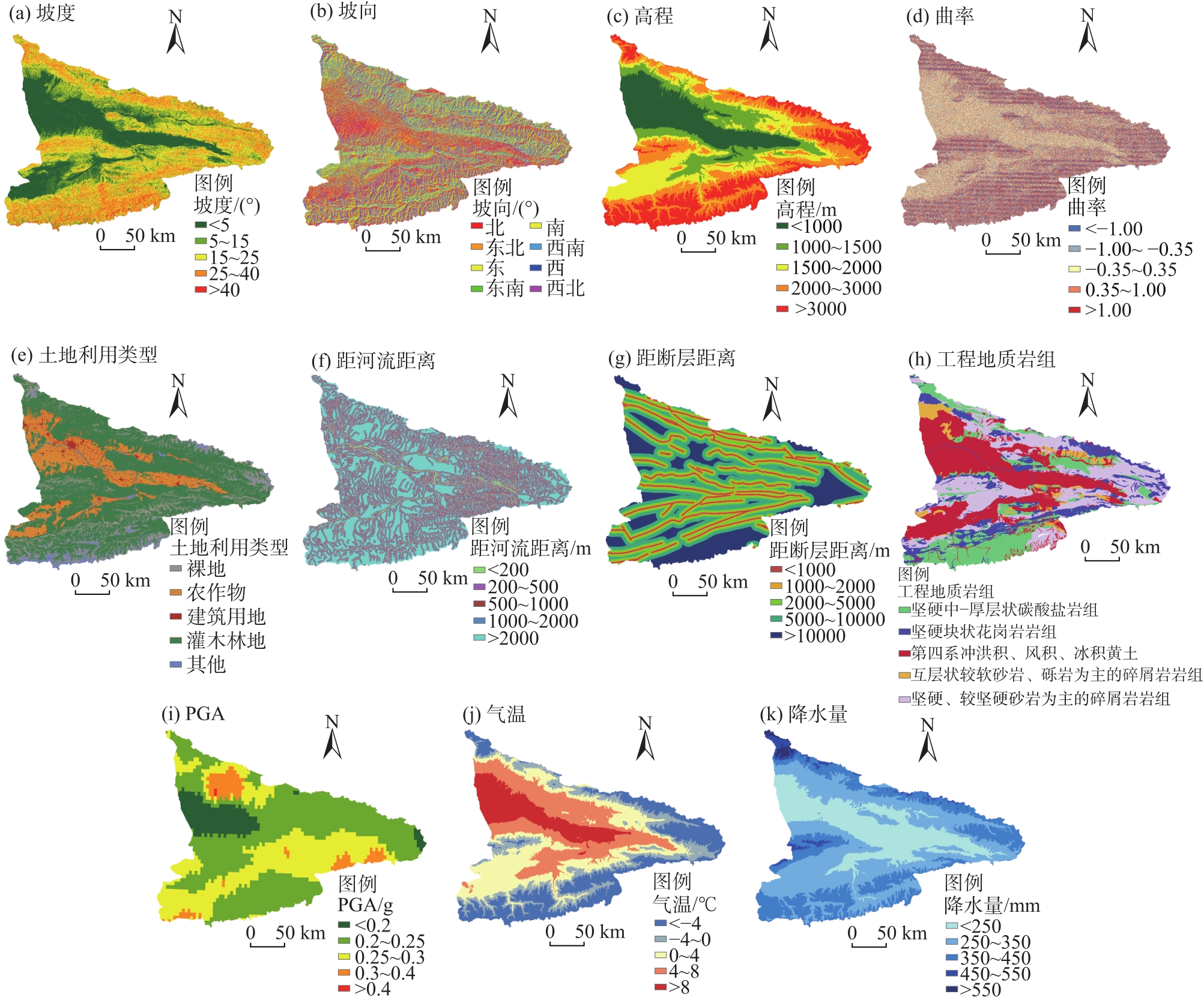
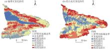
Fig. 7
Geological hazard zoning in the Ili River Basin"

Fig. 8
Time-series variations of annual average temperature and precipitation in the Ili River Basin"
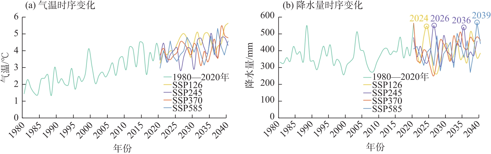
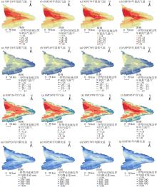
Fig. 9
Temperature and precipitation prediction maps under different scenarios from 2021 to 2040"

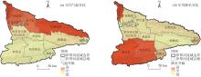
Fig. 10
Changes in annual average temperature and precipitation zones under the SSP585 scenario (compared to 2000—2020)"
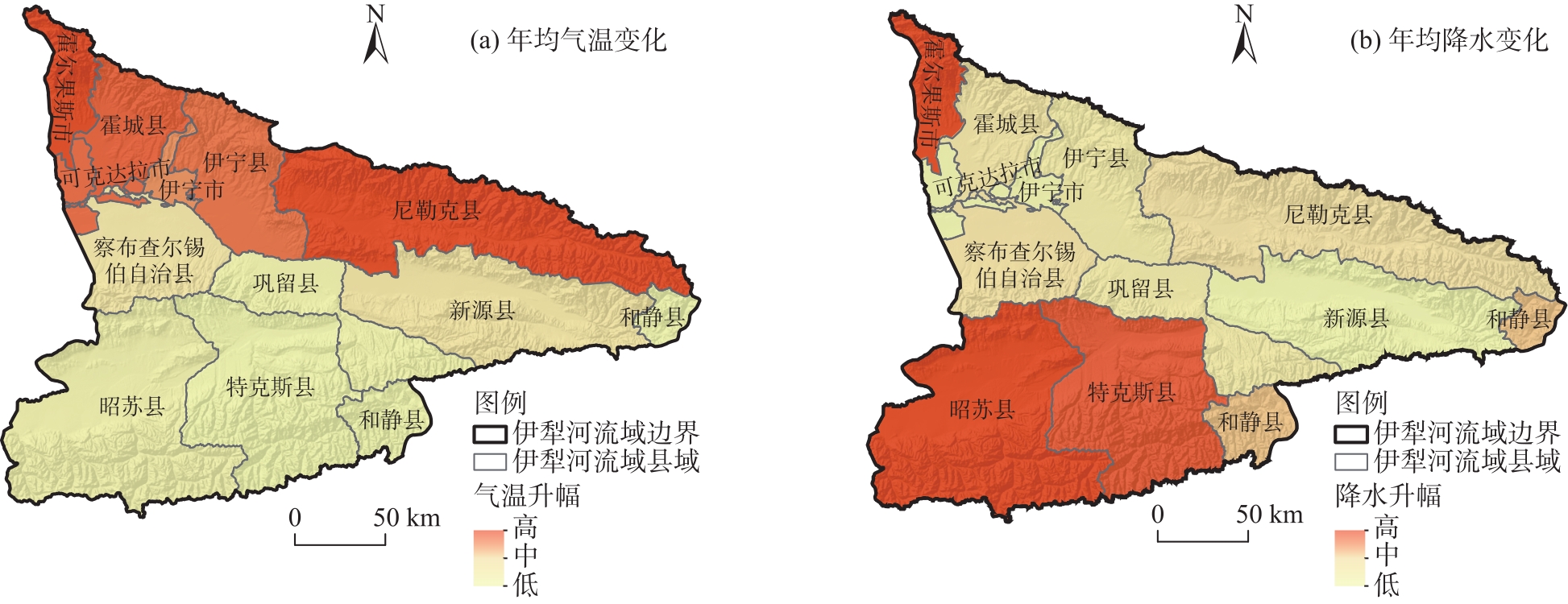
Fig. 11
Landslide and rockfall, debris flow hazard prediction zonation maps under different scenarios from 2021 to 2040"
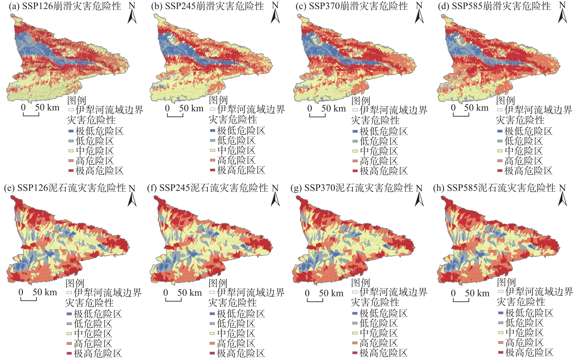
Tab. 3
Proportion of hazard zones under different scenarios in the Ili River Basin /%"
| 崩滑危险区等级 | 2000—2020年 | 2021—2040年 | |||
|---|---|---|---|---|---|
| SSP126 | SSP245 | SSP370 | SSP585 | ||
| 极低危险区 | 15.12 | 7.74 | 10.01 | 8.64 | 5.79 |
| 低危险区 | 17.63 | 8.26 | 11.69 | 10.24 | 10.08 |
| 中危险区 | 27.19 | 35.21 | 35.15 | 28.49 | 26.76 |
| 高危险区 | 24.84 | 28.65 | 27.32 | 31.25 | 32.61 |
| 极高危险区 | 15.22 | 20.14 | 15.83 | 21.38 | 24.76 |
| 泥石流危险区等级 | 2000—2020年 | 2021—2040年 | |||
| SSP126 | SSP245 | SSP370 | SSP585 | ||
| 极低危险区 | 8.71 | 3.21 | 3.11 | 3.02 | 3.28 |
| 低危险区 | 19.71 | 16.86 | 17.47 | 14.64 | 14.94 |
| 中危险区 | 27.47 | 32.58 | 34.86 | 32.71 | 28.90 |
| 高危险区 | 27.83 | 29.12 | 27.79 | 30.06 | 31.34 |
| 极高危险区 | 16.28 | 18.23 | 16.77 | 19.57 | 21.54 |
| [38] | 王政琪, 高学杰, 童尧, 等. 新疆地区未来气候变化的区域气候模式集合预估[J]. 大气科学, 2021, 45(2): 407-423. |
| [Wang Zhengqi, Gao Xuejie, Tong Yao, et al. Future climate change projection over Xinjiang based on an ensemble of regional climate model simulations[J]. Chinese Journal of Atmospheric Sciences, 2021, 45(2): 407-423.] | |
| [1] | 王岩, 王昊, 崔鹏, 等. 气候变化的灾害效应与科学挑战[J]. 科学通报, 2024, 69(2): 286-300. |
| [Wang Yan, Wang Hao, Cui Peng, et al. Disaster effects of climate change and the associated scientific challenges[J]. Chinese Science Bulletin, 2024, 69(2): 286-300.] | |
| [2] | 刘传正, 黄帅. 郑州西部山区“7·20”山洪地质灾害成因研究[J]. 工程地质学报, 2022, 30(3): 931-943. |
| [Liu Chuanzheng, Huang Shuai. Research on “7·20” mountain torrents and geological disasters in Zhengzhou City, Henan Province of China[J]. Journal of Engineering Geology, 2022, 30(3): 931-943.] | |
| [3] | 南赟, 翟淑花, 李岩, 等. 北京地区“23·7”特大暴雨型地质灾害特征及预警成效分析[J]. 中国地质灾害与防治学报, 2024, 35(2): 66-73. |
| [Nan Yun, Zhai Shuhua, Li Yan, et al. Analysis on the characteristics of geological disasters and effectiveness of early warning during heavy rainfall on “23·7” in Beijing[J]. The Chinese Journal of Geological Hazard and Control, 2024, 35(2): 66-73.] | |
| [4] | 吴树仁, 石菊松, 张春山, 等. 地质灾害风险评估技术指南初论[J]. 地质通报, 2009, 28(8): 995-1005. |
| [Wu Shuren, Shi Jusong, Zhang Chunshan, et al. Preliminary discussion on technical guideline for geohazard risk assessment[J]. Geological Bulletin of China, 2009, 28(8): 995-1005.] | |
| [5] | 刘衡秋, 朱志刚, 何维彬. 地质灾害危险性评估工作发展现状及若干技术问题探讨[J]. 中国地质灾害与防治学报, 2008, 19(4): 128-130. |
| [Liu Hengqiu, Zhu Zhigang, He Weibin. Discussion on the current status of geological hazard risk assessment and some technical issues[J]. The Chinese Journal of Geological Hazard and Control, 2008, 19(4): 128-130.] | |
| [6] | Ragozin A L, Tikhvinsky I O. Landslide hazard, vulnerability and risk assessment[C]// Bromhead E, Dixon N, Ibsen M-L. Proceedings of the 8th International Symposium on Landslides. Cardiff: Thomas Telford, 2000: 1257-1262. |
| [7] | Guzzetti F, Reichenbach P, Cardinali M, et al. Probabilistic landslide hazard assessment at the basin scale[J]. Geomorphology, 2005, 72(1-4): 272-299. |
| [8] | Naidu S, Sajinkumar K S, Oommen T, et al. Early warning system for shallow landslides using rainfall threshold and slope stability analysis[J]. Geoscience Frontiers, 2018, 9(6): 1871-1882. |
| [9] | Caleca F, Tofani V, Segoni S, et al. A methodological approach of QRA for slow-moving landslides at a regional scale[J]. Landslides, 2022, 19(7): 1539-1561. |
| [10] | 黄润秋, 李为乐. “5·12”汶川大地震触发地质灾害的发育分布规律研究[J]. 岩石力学与工程学报, 2008, 27(12): 2585-2592. |
| [Huang Runqiu, Li Weile. Research on development and distribution rules of geohazards induced by Wenchuan earthquake on 12th May, 2008[J]. Chinese Journal of Rock Mechanics and Engineering, 2008, 27(12): 2585-2592.] | |
| [11] | 李雪平, 唐辉明. 基于GIS的分组数据Logistic模型在斜坡稳定性评价中的应用[J]. 吉林大学学报(地球科学版), 2005, 35(3): 361-365. |
| [Li Xueping, Tang Huiming. Application of GIS-based grouped data Logistic model in evaluation of slope stability[J]. Journal of Jilin University (Earth Science Edition), 2005, 35(3): 361-365.] | |
| [12] | 刘艺梁, 殷坤龙, 刘斌. 逻辑回归和人工神经网络模型在滑坡灾害空间预测中的应用[J]. 水文地质工程地质, 2010, 37(5): 92-96. |
| [Liu Yiliang, Yin Kunlong, Liu Bin. Application of logistic regression and artificial neural networks in spatial assessment of landslide hazards[J]. Hydrogeology and Engineering Geology, 2010, 37(5): 92-96.] | |
| [13] | 庄建琦, 崔鹏, 郭晓军. 基于水文模型泥石流汇流预测——以蒋家沟一级支沟大凹子沟泥石流为例[J]. 灾害学, 2013, 28(2): 55-59. |
| [Zhuang Jianqi, Cui Peng, Guo Xiaojun. The runoff process of debris flow calculated based on hydrological model: A case study on Dawazi Debris Flow Gully[J]. Journal of Catastrophology, 2013, 28(2): 55-59.] | |
| [14] | 刘艳辉, 方然可, 苏永超, 等. 基于机器学习的区域滑坡灾害预警模型研究[J]. 工程地质学报, 2021, 29(1): 116-124. |
| [Liu Yanhui, Fang Ranke, Su Yongchao, et al. Machine learning based model for warning of regional landslide disasters[J]. Journal of Engineering Geology, 2021, 29(1): 116-124.] | |
| [15] | 田述军, 张珊珊, 唐青松, 等. 基于不同评价单元的滑坡易发性评价对比研究[J]. 自然灾害学报, 2019, 28(6): 137-145. |
| [Tian Shujun, Zhang Shanshan, Tang Qingsong, et al. Comparative study of landslide susceptibility assessment based on different evaluation units[J]. Journal of Natural Disasters, 2019, 28(6): 137-145.] | |
| [16] | 许强, 董秀军, 李为乐. 基于天-空-地一体化的重大地质灾害隐患早期识别与监测预警[J]. 武汉大学学报(信息科学版), 2019, 44(7): 957-966. |
| [Xu Qiang, Dong Xiujun, Li Weile. Integrated space-air-ground early detection, monitoring and warning system for potential catastrophic geohazards[J]. Geomatics and Information Science of Wuhan University, 2019, 44(7): 957-966.] | |
| [17] | Lee J Y, Marotzke J, Bala G, et al. IPCC. Climate change 2021: The physical science basis[M]. Cambridge: Cambridge University Press, 2021: 1-195. |
| [18] |
林齐根, 王磊斌, 张家慧. 全球温升1.5 ℃和2.0 ℃情景下中国降雨诱发地质灾害危险性和人口暴露度评估研究[J]. 地球信息科学学报, 2023, 25(1): 177-189.
doi: 10.12082/dqxxkx.2023.220594 |
| [Lin Qigen, Wang Leibin, Zhang Jiahui. Assessment of the rainfall-induced landslide hazard and population exposure in China under 1.5 ℃ and 2.0 ℃ global warming scenarios[J]. Journal of Geo-information Science, 2023, 25(1): 177-189.] | |
| [19] | Lin Q, Wang Y, Glade T, et al. Assessing the spatiotemporal impact of climate change on event rainfall characteristics influencing landslide occurrences based on multiple GCM projections in China[J]. Climatic Change, 2020(11): 162, 761-779. |
| [20] | 王霞, 王瑛, 林齐根, 等. 气候变化背景下中国滑坡灾害人口风险评估[J]. 气候变化研究进展, 2022, 18(2): 166-176. |
| [Wang Xia, Wang Ying, Lin Qigen, et al. Projection of China landslide disasters population risk under climate change[J]. Climate Change Research, 2022, 18(2): 166-176.] | |
| [21] | 杨奉广, 木合塔尔·扎日, 封丽华. 新疆伊犁地区地质灾害的形成与防治对策[J]. 新疆师范大学学报(自然科学版), 2005, 24(3): 117-120. |
| [Yang Fengguang, Zhari Muhetaer, Feng Lihua. Formation of geological hazards in Yili area and measures for controls and prevention[J]. Journal of Xinjiang Normal University (Natural Science Edition), 2005, 24(3): 117-120.] | |
| [22] | 胡卫忠. 新疆的干旱环境与滑坡、泥石流及其防治对策[J]. 地质灾害与环境保护, 1994(3): 1-7. |
| [Hu Weizhong. Arid environment, landslides and debris flow in Xinjiang and its preservation and controlling[J]. Geological Hazards and Environment Preservation, 1994(3): 1-7.] | |
| [23] | 陈亚宁, 李卫红. 新疆干旱区地质灾害区划与减灾对策[J]. 中国地质灾害与防治学报, 1995(4): 75-80. |
| [Chen Yaning, Li Weihong. Zoning of geological hazards and countermeasures for its reduction in Xinjiang arid region[J]. The Chinese Journal of Geological Hazard and Control, 1995(4): 75-80.] | |
| [24] |
梁世川, 乔华, 吕东, 等. 伊犁谷地地质灾害分布特征及主控因素分析[J]. 干旱区地理, 2023, 46(6): 880-888.
doi: 10.12118/j.issn.1000-6060.2022.458 |
|
[Liang Shichuan, Qiao Hua, Lü Dong, et al. Distribution characteristics and main controlling factors of geohazards in Ili Valley[J]. Arid Land Geography, 2023, 46(6): 880-888.]
doi: 10.12118/j.issn.1000-6060.2022.458 |
|
| [25] | 周昌, 黄顺. 新疆伊犁黄土工程地质特征及致灾机理研究综述[J]. 工程地质学报, 2023, 31(4): 1247-1260. |
| [Zhou Chang, Huang Shun. Mechanical properties and disaster-causing mechanism of loess in Ili, Xinjiang, China[J]. Journal of Engineering Geology, 2023, 31(4): 1247-1260.] | |
| [26] | 王双双, 谢文强, 延晓冬. CMIP6模式对中国气温日较差的模拟能力评估[J]. 气候与环境研究, 2022, 27(1): 79-93. |
| [Wang Shuangshuang, Xie Wenqiang, Yan Xiaodong. Evaluation on CMIP6 model simulation of the diurnal temperature range over China[J]. Climatic and Environmental Research, 2022, 27(1): 79-93.] | |
| [27] | 胡一阳, 徐影, 李金建, 等. CMIP6不同分辨率全球气候模式对中国降水模拟能力评估[J]. 气候变化研究进展, 2021, 17(6): 730-743. |
| [Hu Yiyang, Xu Ying, Li Jinjian, et al. Evaluation on the performance of CMIP6 global climate models with different horizontal resolution in simulating the precipitation over China[J]. Climate Change Research, 2021, 17(6): 730-743.] | |
| [28] | 张丽霞, 陈晓龙, 辛晓歌. CMIP6情景模式比较计划(ScenarioMIP)概况与评述[J]. 气候变化研究进展, 2019, 15(5): 519-525. |
| [Zhang Lixia, Chen Xiaolong, Xin Xiaoge. Short commentary on CMIP6 scenario model intercomparison project (ScenarioMIP)[J]. Climate Change Research, 2019, 15(5): 519-525.] | |
| [29] | 曹小红, 孟和, 尚彦军, 等. 伊犁谷地黄土滑坡发育分布规律及成因[J]. 新疆地质, 2020, 38(3): 405-411. |
| [Cao Xiaohong, Meng He, Shang Yanjun, et al. The development and distribution of loess landslides in Yili Valley and its causes[J]. Xinjiang Geology, 2020, 38(3): 405-411.] | |
| [30] | 罗路广, 裴向军, 崔圣华, 等. 九寨沟地震滑坡易发性评价因子组合选取研究[J]. 岩石力学与工程学报, 2021, 40(11): 2306-2319. |
| [Luo Luguang, Pei Xiangjun, Cui Shenghua, et al. Combined selection of susceptibility assessment factors for Jiuzhaigou earthquake-induced landslides[J]. Chinese Journal of Rock Mechanics and Engineering, 2021, 40(11): 2306-2319.] | |
| [31] | 易靖松, 王峰, 程英建, 等. 高山峡谷区地质灾害危险性评价——以四川省阿坝县为例[J]. 中国地质灾害与防治学报, 2022, 33(3): 134-142. |
| [Yi Jingsong, Wang Feng, Cheng Yingjian, et al. Study on the risk assessment of geological disasters in alpine valley area: A case study in Aba County, Sichuan Province[J]. The Chinese Journal of Geological Hazard and Control, 2022, 33(3): 134-142.] | |
| [32] | 阮沈勇, 黄润秋. 基于GIS的信息量法模型在地质灾害危险性区划中的应用[J]. 成都理工学院学报, 2001, 28(1): 89-92. |
| [Ruan Shenyong, Huang Runqiu. Application of GIS-based information model on assessment of geological hazards risk[J]. Journal of Chengdu University of Technology, 2001, 28(1): 89-92.] | |
| [33] | Breiman L. Random forests[J]. Machine Learning, 2001, 45: 5-32. |
| [34] | 林荣福, 刘纪平, 徐胜华, 等. 随机森林赋权信息量的滑坡易发性评价方法[J]. 测绘科学, 2020, 45(12): 131-138. |
| [Lin Rongfu, Liu Jiping, Xu Shenghua, et al. Evaluation method of landslide susceptibility based on random forest weighted information[J]. Science of Surveying and Mapping, 2020, 45(12): 131-138.] | |
| [35] | 牛磊, 古丽波斯坦·吐逊江, 王昙昙, 等. 新疆地区地质灾害分布特征及主控因素分析[J]. 西部探矿工程, 2023, 35(11): 38-41. |
| [Niu Lei, Tursunjiang Gulibostan, Wang Tantan, et al. Analysis of the distribution characteristics and main controlling factors of geological disasters in Xinjiang region[J]. Western Exploration Engineering, 2023, 35(11): 38-41.] | |
| [36] |
Tang J, Guo X, Chang Y, et al. Temporospatial distribution and trends of thunderstorm, hail, gale, and heavy precipitation events over the Tibetan Plateau and associated mechanisms[J]. Journal of Climate, 2021, 34(24): 9623-9646.
doi: 10.1175/JCLI-D-21-0494.1 |
| [37] | 张晓璐, 王晓欣, 华丽娟, 等. 新疆温度和降水变化的CMIP6模式预估[J]. 大气科学, 2023, 47(2): 387-398. |
| [Zhang Xiaolu, Wang Xiaoxin, Hua Lijuan, et al. Projections of temperature and precipitation over Xinjiang based on CMIP6 models[J]. Chinese Journal of Atmospheric Sciences, 2023, 47(2): 387-398.] |
| [1] | YAO Di, ZHANG Ziwen, HAN Weiwei. Distinguishing climate- and human-driven water storage anomalies in the Yellow River Basin [J]. Arid Land Geography, 2025, 48(2): 190-201. |
| [2] | KANG Limin, TENG Xinru, CHE Jiahang, HUAI Baojuan. Spatiotemporal variations of snow cover on the northern slope of Kunlun Mountains [J]. Arid Land Geography, 2024, 47(9): 1462-1471. |
| [3] | WANG Nan, LIU Zexuan, ZHENG Jianghua, ZHONG Tao, MENG Chengfeng. Spatiotemporal characteristics and driving forces of glacial lakes in Tianshan Mountains [J]. Arid Land Geography, 2024, 47(9): 1472-1481. |
| [4] | CHAO Bao, ZHAO Yuanyuan, WU Haiyan, LI Yuan, SU Ning. Ecosystem services and its response to climate factors in the Mongolian Plateau from 2000 to 2020 [J]. Arid Land Geography, 2024, 47(9): 1577-1586. |
| [5] | XIA Tingting, XUE Xuan, WANG Haowei, XU Wenzhe, SHENG Ziyi, WANG Yang. Changes in terrestrial water storage and its drivers on the north slope of Kunlun Mountains [J]. Arid Land Geography, 2024, 47(8): 1292-1303. |
| [6] | Gulzar MOMIN, YANG Lianmei, LIU Yan, LI Xinguo. Spatial and temporal distribution of flood disasters and characteristics of disaster-prone environment in Ili River Basin in recent 30 years [J]. Arid Land Geography, 2024, 47(8): 1314-1326. |
| [7] | ZHU Chenggang, CHEN Yaning, ZHANG Mingjun, CHE Yanjun, SUN Meiping, ZHAO Ruifeng, WANG Yang, LIU Yuting. Preliminary report on scientific investigation of water resources on the northern slope of Kunlun Mountains [J]. Arid Land Geography, 2024, 47(7): 1097-1105. |
| [8] | ZHANG Jing, MA Long, LIU Tingxi, SUN Bolin, QIAO Zixu. Reconstruction of the minimum temperature over the past 202 years based on tree rings of Picea crassifolia in the Helan Mountains [J]. Arid Land Geography, 2024, 47(6): 909-921. |
| [9] | FAN Jing, SHEN Yanbo, CHANG Rui. Impact of climate change on the selection of typical meteorological years in solar energy resource assessment [J]. Arid Land Geography, 2024, 47(6): 922-931. |
| [10] | LI Hui, LIU Tiejun, WANG Shaohui, LIU Dongwei. Spatial and temporal variation of water use efficiency and its influencing factors in desert steppe of Inner Mongolia from 2001 to 2021 [J]. Arid Land Geography, 2024, 47(6): 993-1003. |
| [11] | LI Yaqian, YANG Jianhua, XIA Haobin, WU Jianjun. Spatiotemporal variations of vegetation in the Ili River Basin from 2000 to 2022 [J]. Arid Land Geography, 2024, 47(5): 741-752. |
| [12] | XIANG Yanyun, WANG Yi, CHEN Yaning, ZHANG Qifei, ZHANG Yujie. Prediction of future hydrological drought risk in the Yarkant River Basin based on CMIP6 models [J]. Arid Land Geography, 2024, 47(5): 798-809. |
| [13] | ZHAO Mingjie, WANG Ninglian, SHI Chenlie, HOU Jingqi. Temporal and spatial variations of lake ice phenology in large lakes of Central Asia from 2000 to 2020 [J]. Arid Land Geography, 2024, 47(4): 561-575. |
| [14] | LU Dongyan, ZHU Xiufang, TANG Mingxiu, GUO Chunhua, LIU Tingting. Assessment of drought risk changes in China under different temperature rise scenarios [J]. Arid Land Geography, 2024, 47(3): 369-379. |
| [15] | WANG Shuzhi, WEN Deping. Attribution analysis of runoff change in the Datong River Basin, Qinghai-Tibet Plateau [J]. Arid Land Geography, 2024, 47(2): 203-213. |
| Viewed | ||||||||||||||||||||||||||||||||||||||||||||||||||
|
Full text 38
|
|
|||||||||||||||||||||||||||||||||||||||||||||||||
|
Abstract 60
|
|
|||||||||||||||||||||||||||||||||||||||||||||||||
Cited |
|
|||||||||||||||||||||||||||||||||||||||||||||||||
| Shared | ||||||||||||||||||||||||||||||||||||||||||||||||||
|
||