Arid Land Geography ›› 2023, Vol. 46 ›› Issue (1): 11-22.doi: 10.12118/j.issn.1000-6060.2022.165
• Climatology and Hydrology • Previous Articles Next Articles
ZHANG Juan( ),YAO Xiaojun(),LI Jing,WANG Xiaoyan
Received:2022-04-19
Revised:2022-07-05
Online:2023-01-25
Published:2023-02-21
ZHANG Juan, YAO Xiaojun, LI Jing, WANG Xiaoyan. Agricultural drought research based on multi-source remote sensing data in Gansu Province[J].Arid Land Geography, 2023, 46(1): 11-22.

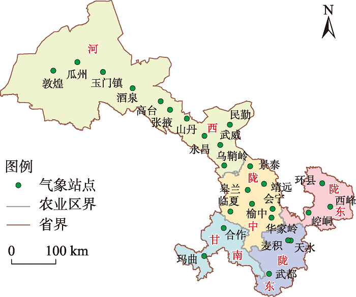
Fig. 1
Agricultural division of Gansu Province"
Tab. 1
Calculation method of drought index"
| 干旱指数 | 计算公式 | 符号含义 |
|---|---|---|
| 植被状态指数(VCI) | NDVI为归一化植被指数;NDVImax、NDVImin分别为某月归一化植被指数的最大值和最小值。 | |
| 温度状态指数(TCI) | LST为地表温度即地面的温度(℃);LSTmax、LSTmin分别为某月地表温度的最高值和最低值(℃)。 | |
| 降水状态指数(PCI) | TRMM为卫星降水数据,表征降水量的大小(mm·h-1);TRMMmax、TRMMmin分别为某月降水量的最大值和最小值(mm) | |
| 土壤湿度状态指数(SMCI) | SM为土壤湿度;SMmax、SMmin分别为某月土壤湿度的最大值和最小值。 | |
| 温度植被干旱指数(TVDI) | ||
| 微波综合干旱指数(MIDI) | α、β分别为PCI、TCI的权重值。 |
Tab. 2
Classification of drought with respect to CMDI and SPEI"
| 等级 | 类型 | 综合气象干旱指数 | 标准化降水蒸散发指数 |
|---|---|---|---|
| 1 | 无旱 | -0.6<CMDI | -0.5<SPEI |
| 2 | 轻旱 | -1.2<CMDI≤-0.6 | -1.0<SPEI≤-0.5 |
| 3 | 中旱 | -1.8<CMDI≤-1.2 | -1.5<SPEI≤-1.0 |
| 4 | 重旱 | -2.4<CMDI≤-1.8 | -2.0<SPEI≤-1.5 |
| 5 | 特旱 | CMDI≤-2.4 | SPEI≤-2.0 |
Fig. 2
Flow chart of random forest model construction"
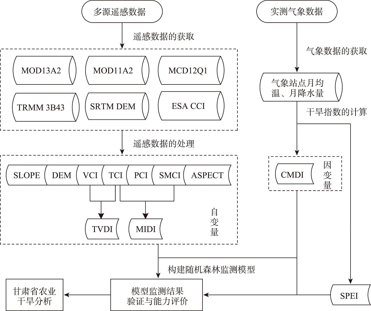
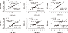
Fig. 3
Scatter diagrams of simulated CMDI and measured CMDI of meteorological stations from April to September"
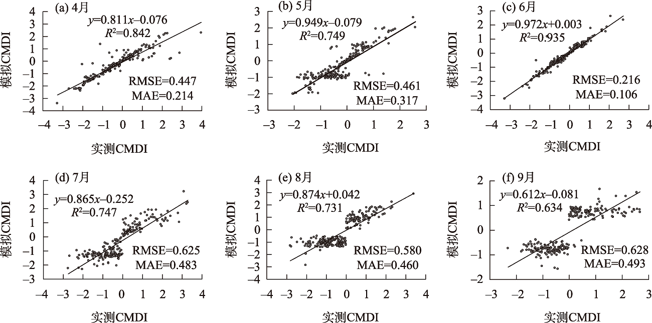

Fig. 4
Spatial correlation between simulated CMDI and SPEI from April to September"

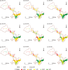
Fig. 5
Agricultural drought degree in Gansu Province during 2011—2019"

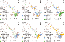
Fig. 6
Trends of agricultural drought in Gansu Province from April to September during 2011—2019"


Fig. 7
Averaged simulated CMDI from April to September during 2011—2019"
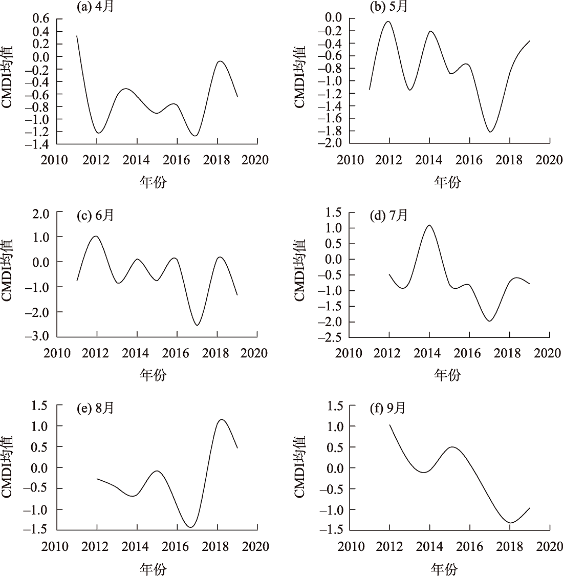
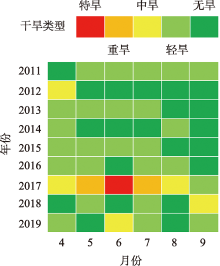
Fig. 8
Drought degree in different years or months"

| [1] | 张世喆, 朱秀芳, 刘婷婷, 等. 基于多维Copula的中国干旱特征及危险性分析[J]. 干旱区地理, 2022, 45(2): 333-345. |
| [Zhang Shizhe, Zhu Xiufang, Liu Tingting, et al. Drought characteristics and risk hazard in China based on multidimensional Copula model[J]. Arid Land Geography, 2022, 45(2): 333-345.] | |
| [2] | 范磊, 吕爱锋, 张文翔. 青海省干旱时空特征及与大气环流响应关系[J]. 干旱区资源与环境, 2021, 35(12): 60-65. |
| [Fan Lei, Lü Aifeng, Zhang Wenxiang. Temporal-spatial variation characteristics of drought and its relationship with atmospheric circulation in Qinghai Province[J]. Journal of Arid Land Resources and Environment, 2021, 35(12): 60-65.] | |
| [3] | IPCC. Climate Change 2021: The physical science basis: Contribution of working group I to the sixth assessment report of the intergovernmental panel on climate change[M]. Cambridge: Cambridge University Press, 2021. |
| [4] | Thilagaraj P, Masilamani P, Venkatesh R, et al. Google earth engine based agricultural drought monitoring in Kodavanar Watershed, part of Amaravathi Basin, Tamil Nadu, India[J]. International Archives of the Photogrammetry, Remote Sensing and Spatial Information Sciences, 2021, XLIII-B5-2021: 43-49. |
| [5] | 孙灏, 陈云浩, 孙洪泉. 典型农业干旱遥感监测指数的比较及分类体系[J]. 农业工程学报, 2012, 28(14): 147-154. |
| [Sun Hao, Chen Yunhao, Sun Hongquan. Comparisons and classification system of typical remote sensing indexes for agricultural drought[J]. Transactions of the Chinese Society of Agricultural Engineering, 2012, 28(14): 147-154.] | |
| [6] |
吴泽棉, 邱建秀, 刘苏峡, 等. 基于土壤水分的农业干旱监测研究进展[J]. 地理科学进展, 2020, 39(10): 1758-1769.
doi: 10.18306/dlkxjz.2020.10.014 |
|
[Wu Zemian, Qiu Jianxiu, Liu Suxia, et al. Advances in agricultural drought monitoring based on soil moisture[J]. Progress in Geography, 2020, 39(10): 1758-1769.]
doi: 10.18306/dlkxjz.2020.10.014 |
|
| [7] |
Dai A. Increasing drought under global warming in observations and models[J]. Nature Climate Change, 2013, 3(1): 52-58.
doi: 10.1038/nclimate1633 |
| [8] |
刘宪锋, 朱秀芳, 潘耀忠, 等. 农业干旱监测研究进展与展望[J]. 地理学报, 2015, 70(11): 1835-1848.
doi: 10.11821/dlxb201511012 |
|
[Liu Xianfeng, Zhu Xiufang, Pan Yaozhong, et al. Agricultural drought monitor: Progress, challenges and prospect[J]. Acta Geographica Sinica, 2015, 70(11): 1835-1848.]
doi: 10.11821/dlxb201511012 |
|
| [9] |
Lee S J, Kim N R, Lee Y W. Development of integrated crop drought index by combining rainfall, land surface temperature, evapotranspiration, soil moisture, and vegetation index for agricultural drought monitoring[J]. Remote Sensing, 2021, 13(9): 1778, doi: 10.3390/rs13091778.
doi: 10.3390/rs13091778 |
| [10] | 胡鹏飞, 李净, 王丹, 等. 基于MODIS和TRMM数据的黄土高原农业干旱监测[J]. 干旱区地理, 2019, 42(1): 173-178. |
| [Hu Pengfei, Li Jing, Wang Dan, et al. Monitoring agricultural drought in the Loess Plateau using MODIS and TRMM data[J]. Arid Land Geography, 2019, 42(1): 173-178.] | |
| [11] | 温庆志, 孙鹏, 张强, 等. 基于多源遥感数据的农业干旱监测模型构建及应用[J]. 生态学报, 2019, 39(20): 7757-7770. |
| [Wen Qingzhi, Sun Peng, Zhang Qiang, et al. An integrated agricultural drought monitoring model based on multi-source remote sensing data: Model development and application[J]. Acta Ecologica Sinica, 2019, 39(20): 7757-7770.] | |
| [12] |
刘高鸣, 谢传节, 何天乐. 基于多源数据的农业干旱监测模型构建[J]. 地球信息科学学报, 2019, 21(11): 1811-1822.
doi: 10.12082/dqxxkx.2019.180666 |
|
[Liu Gaoming, Xie Chuanjie, He Tianle. Agricultural drought monitoring model constructing based on multi-source data[J]. Journal of Geo-information Science, 2019, 21(11): 1811-1822.]
doi: 10.12082/dqxxkx.2019.180666 |
|
| [13] | Brown J F, Wardlow B D, Tadesse T, et al. The vegetation drought response index (VegDRI): A new integrated approach for monitoring drought stress in vegetation[J]. GIScience & Remote Sensing, 2008, 45(1): 16-46. |
| [14] |
Wu J, Zhou L, Liu M, et al. Establishing and assessing the integrated surface drought index (ISDI) for agricultural drought monitoring in mid-eastern China[J]. International Journal of Applied Earth Observation and Geoinformation, 2013, 23: 397-410.
doi: 10.1016/j.jag.2012.11.003 |
| [15] | 邵京, 李晓松, 杨珺婷, 等. 光学与雷达遥感协同的大尺度草地灌丛化监测研究[J]. 干旱区资源与环境, 2021, 35(2): 130-135. |
| [Shao Jing, Li Xiaosong, Yang Junting, et al. Study on large scale grassland shrub monitoring based on optical and radar remote sensing[J]. Journal of Arid Land Resources and Environment, 2021, 35(2): 130-135.] | |
| [16] | 刘斌, 郭星, 朱宇恩. 基于随机森林模型的土壤重金属源解析——以晋中盆地为例[J]. 干旱区资源与环境, 2019, 33(1): 106-111. |
| [Liu Bin, Guo Xing, Zhu Yu’en. Analysis of soil heavy metal sources in Jinzhong Basin based on random forest model[J]. Journal of Arid Land Resources and Environment, 2019, 33(1): 106-111.] | |
| [17] |
高亮, 杜鑫, 李强子, 等. 融合土地覆盖和土壤水分产品的近地表空气温度空间化方法[J]. 地球信息科学学报, 2020, 22(10): 2023-2037.
doi: 10.12082/dqxxkx.2020.200078 |
|
[Gao Liang, Du Xin, Li Qiangzi, et al. A near-surface air temperature spatialization method integrating landuse and soil moisture products[J]. Journal of Geo-information Science, 2020, 22(10): 2023-2037.]
doi: 10.12082/dqxxkx.2020.200078 |
|
| [18] | 沈润平, 郭佳, 张婧娴. 基于随机森林的遥感干旱监测模型的构建[J]. 地球信息科学学报, 2016, 19(1): 125-133. |
| [Shen Runping, Guo Jia, Zhang Jingxian. Construction of a drought monitoring model using the random forest based remote sensing[J]. Journal of Geo-information Science, 2016, 19(1): 125-133.] | |
| [19] | 董婷, 任东, 邵攀, 等. 基于多源遥感数据和随机森林的综合旱情指标构建[J]. 农业机械学报, 2019, 50(8): 200-212. |
| [Dong Ting, Ren Dong, Shao Pan, et al. Construction of integrated drought condition index based on multi-sensor remote sensing and random forest[J]. Transactions of the Chinese Society for Agricultural Machinery, 2019, 50(8): 200-212.] | |
| [20] | 庞素菲, 魏伟, 郭泽呈, 等. 基于TVDI的甘肃省农业旱情特征及其影响因素[J]. 生态学杂志, 2019, 38(6): 1849-1860. |
| [Pang Sufei, Guo Zecheng, et al. Agricultural drought characteristics and its influencing factors in Gansu Province based on TVDI[J]. Chinese Journal of Ecology, 2019, 38(6): 1849-1860.] | |
| [21] | 胡蝶, 沙莎, 王丽娟, 等. 欧空局主被动微波土壤水分融合产品在甘肃省干旱监测中的应用[J]. 干旱气象, 2019, 37(4): 517-528. |
| [Hu Die, Wang Lijuan, et al. Drought monitoring applications of the European space agency climate change initiative soil moisture combined product in Gansu Province[J]. Journal of Arid Meteorology, 2019, 37(4): 517-528.] | |
| [22] | 魏堃, 张勃, 马尚谦, 等. 甘肃省河东地区春玉米干旱演变特征及灾损风险区划[J]. 干旱地区农业研究, 2019, 37(6): 238-247. |
| [Wei Kun, Zhang Bo, Ma Shangqian, et al. Drought evolution characteristics and risk zoning of spring maize in Hedong of Gansu Province[J]. Agricultural Research in the Arid Areas, 2019, 37(6): 238-247.] | |
| [23] | 李栋梁, 刘德祥. 甘肃气候[M]. 北京: 气象出版社, 2000: 2-105. |
| [Li Dongliang, Liu Dexiang. Gansu climate[M]. Beijing: Meteorological Publishing House, 2000: 2-105.] | |
| [24] |
郭斌, 邢文雪, 李云, 等. 基于TRMM 3B43产品的1998—2016年黄淮海平原降水时空特征研究[J]. 地理科学, 2021, 41(7): 1285-1294.
doi: 10.13249/j.cnki.sgs.2021.07.019 |
|
[Guo Bin, Xing Wenxue, Li Yun, et al. Temporal and spatial characteristics of precipitation based on TRMM 3B43 product in the Huang-Huai-Hai Plain during 1998—2016[J]. Scientia Geographica Sinica, 2021, 41(7): 1285-1294.]
doi: 10.13249/j.cnki.sgs.2021.07.019 |
|
| [25] |
彭振华, 李艳忠, 余文君, 等. 遥感降水产品在中国不同气候区的适用性研究[J]. 地球信息科学学报, 2021, 23(7): 1296-1311.
doi: 10.12082/dqxxkx.2021.200348 |
|
[Peng Zhenhua, Li Yanzhong, Yu Wenjun, et al. Research on the applicability of remote sensing precipitation products in different climatic regions of China[J]. Journal of Geo-information Science, 2021, 23(7): 1296-1311.]
doi: 10.12082/dqxxkx.2021.200348 |
|
| [26] |
费龙, 邓国荣, 张洪岩, 等. 基于降水Z指数的朝鲜降水及旱涝时空特征[J]. 自然资源学报, 2020, 35(12): 3051-3063.
doi: 10.31497/zrzyxb.20201219 |
|
[Fei Long, Deng Guorong, Zhang Hongyan, et al. Spatiotemporal patterns of precipitation and drought and flood using Z-index in Democratic People’s Republic of Korea[J]. Journal of Natural Resources, 2020, 35(12): 3051-3063.]
doi: 10.31497/zrzyxb.20201219 |
|
| [27] |
余灏哲, 李丽娟, 李九一. 基于TRMM降尺度和MODIS数据的综合干旱监测模型构建[J]. 自然资源学报, 2020, 35(10): 2553-2568.
doi: 10.31497/zrzyxb.20201019 |
|
[Yu Haozhe, Li Lijuan, Li Jiuyi. Establishment of comprehensive drought monitoring model based on downscaling TRMM and MODIS data[J]. Journal of Natural Resources, 2020, 35(10): 2553-2568.]
doi: 10.31497/zrzyxb.20201019 |
|
| [28] |
李净, 张晓. TRMM降水数据的空间降尺度方法研究[J]. 地理科学, 2015, 35(9): 1164-1169.
doi: 10.13249/j.cnki.sgs.2015.09.1164 |
|
[Li Jing, Zhang Xiao. Downscaling method of TRMM satellite precipitation data[J]. Scientia Geographica Sinica, 2015, 35(9): 1164-1169.]
doi: 10.13249/j.cnki.sgs.2015.09.1164 |
|
| [29] | Yu G, Di L. Downscaling of global soil moisture using auxiliary data[C]// Yang W. International Geoscience & Remote Sensing Symposium. Institute of Electrical and Electronics Engineers, 2008: 230-233. |
| [30] | 杜灵通, 田庆久, 王磊, 等. 基于多源遥感数据的综合干旱监测模型构建[J]. 农业工程学报, 2014, 30(9): 126-132. |
| [Du Lingtong, Tian Qingjiu, Wang Lei, et al. A synthesized drought monitoring model based on multi-source remote sensing data[J]. Transactions of the Chinese Society of Agricultural Engineering, 2014, 30(9): 126-132.] | |
| [31] | 张静, 魏伟, 庞素菲, 等. 基于FY-3C和TRMM数据的西北干旱区干旱监测与评估[J]. 生态学杂志, 2020, 39(2): 690-702. |
| [Zhang Jing, Pang Sufei, et al. Monitoring and assessment of drought in arid area in northwest China based on FY-3C and TRMM Data[J]. Chinese Journal of Ecology, 2020, 39(2): 690-702.] | |
| [32] | 谢五三, 田红, 王胜. 基于CI指数的淮河流域干旱时空特征研究[J]. 气象, 2013, 39(9): 1171-1175. |
| [Xie Wusan, Tian Hong, Wang Sheng. Study on temporal-spatial characteristics of drought in Huaihe River Basin based on CI index[J]. Meteorological Monthly, 2013, 39(9): 1171-1175.] | |
| [33] | GBT 20481. 2006气象干旱等级[S]. 2006: 40-41. |
| [GBT 20481. Meteorological drought grade in 2006[S]. 2006: 40-41.] | |
| [34] |
张调风, 张勃, 王有恒, 等. 基于综合气象干旱指数的石羊河流域近50年气象干旱特征分析[J]. 生态学报, 2013, 33(3): 975-984.
doi: 10.5846/stxb201203030285 |
|
[Zhang Tiaofeng, Zhang Bo, Wang Youheng, et al. Drought characteristics in the Shiyang River Basin during the recent 50 years based on a composite index[J]. Acta Ecologica Sinica, 2013, 33(3): 975-984.]
doi: 10.5846/stxb201203030285 |
|
| [35] |
Vicente-Serrano S M, Beguería S, López-Moreno J I. A multiscalar drought index sensitive to global warming: The standardized precipitation evapotranspiration index-SPEI[J]. Journal of Climate, 2010, 23(7): 1696-1718.
doi: 10.1175/2009JCLI2909.1 |
| [36] | 芳馨蕊, 温兆飞, 陈吉龙, 等. 基于随机森林回归模型的悬浮泥沙浓度遥感估算[J]. 遥感学报, 2019, 23(4): 756-772. |
| [Fang Xinrui, Wen Zhaofei, Chen Jilong, et al. Remote sensing estimation of suspended sediment concentration based on random forest regression model[J]. National Remote Sensing Bulletin, 2019, 23(4): 756-772.] | |
| [37] | 任丽, 杨联安, 王辉, 等. 基于随机森林的苹果区土壤有机质空间预测[J]. 干旱区资源与环境, 2018, 32(8): 141-146. |
| [Ren Li, Yang Lian’an, Wang Hui, et al. Spatial prediction of soil organic matter in apple region based on random forest[J]. Journal of Arid Land Resources and Environment, 2018, 32(8): 141-146.] | |
| [38] | 洪文泉. 甘肃发布2017年十大天气气候事件[N]. 甘肃日报, 2018-01-04( 008). |
| [Hong Wenquan. Gansu released the top 10 weather and climate events of 2017[N]. Gansu Daily, 2018-01-04( 008).] | |
| [39] | 韩兰英, 张强, 赵红岩, 等. 甘肃省农业干旱灾害损失特征及其对气候变暖的响应[J]. 中国沙漠, 2016, 36(3): 767-776. |
| [Han Lanying, Zhang Qiang, Zhao Hongyan, et al. The characteristics agricultural drought disaster loss and response to climate warming in Gansu, China[J]. Journal of Desert Research, 2016, 36(3): 767-776.] | |
| [40] | 赖力, 粟晓玲, 冯凯. 甘肃省农业干旱对多尺度气象干旱的响应[J]. 节水灌溉, 2020(2): 102-108. |
| [Lai Li, Su Xiaoling, Feng Kai. Response of agricultural drought to multi-scale meteorological drought in Gansu Province[J]. Water Saving Irrigation, 2020(2): 102-108.] |
| [1] | MENG Xiao, TIAN Minghua, DU Lei, MA Shuang. Measurement and its coordination of the development level of agricultural and rural modernization in China [J]. Arid Land Geography, 2024, 47(1): 137-146. |
| [2] | ZHANG Junxia, HUANG Wubin, LI Antai, YANG Xiumei, LI Qian, BIAN Hongwei. Fine meteorological risk early warning forecast of main geological disasters in Gansu Province [J]. Arid Land Geography, 2023, 46(9): 1443-1452. |
| [3] | YANG Sicun,HUO Lin,WANG Chengbao,WEN Meijuan. Characteristics of agricultural carbon emissions in Gansu Province based on STIRPAT model [J]. Arid Land Geography, 2023, 46(9): 1493-1502. |
| [4] | MA Zhenbang,WANG Sijian,LI Wei,LYU Peng,GUO Xiaodong. Poverty evolution and its implications in the Liupan Mountain Area of Gansu Province from 1986 to 2020 [J]. Arid Land Geography, 2023, 46(9): 1545-1555. |
| [5] | CHEN Long, ZHANG Zhibin, ZHAO Xuewei, GUO Qianqian, GUO yan. Formation mechanism and development strategy of regional spatial pattern of Gansu Province [J]. Arid Land Geography, 2023, 46(9): 1556-1566. |
| [6] | LU Dongyan, ZHU Xiufang, LIU Tingting, ZHANG Shizhe. Changes in meteorological drought characteristics in China under the 2 ℃ temperature rise scenario [J]. Arid Land Geography, 2023, 46(8): 1227-1237. |
| [7] | TANG Taibin, ZHOU Bao, JIN Xiaomei, WEI Sailajia, MA Tao, ZHANG Yongyan. Change of surface temperature in the source area of the Yellow River in summer [J]. Arid Land Geography, 2023, 46(8): 1250-1259. |
| [8] | CHENG Shuo, LI Yanzhong, XING Yincong, YU Zhiguo, WANG Yuangang, HUANG Manjie. Simulation performance of remote sensing precipitation products on hydrological drought characteristics in the source region of the Yellow River [J]. Arid Land Geography, 2023, 46(7): 1063-1072. |
| [9] | YANG Xuewen, WANG Ninglian, LIANG Qian, CHEN An’an. Glacier changes on the north slope of Tianshan Mountains in recent 60 years [J]. Arid Land Geography, 2023, 46(7): 1073-1083. |
| [10] | SHI Jiqing, GAN Chenlong, ZHOU Kanshe, YUAN Lei, ZHANG Dongdong. Spatiotemporal distribution of drought and hazard assessment of highland barley in Tibet [J]. Arid Land Geography, 2023, 46(7): 1098-1110. |
| [11] | LI Shiyao, CONG Shixiang, WANG Rongrong, YU Hailong, HUANG Juying. Monitoring of maize canopy SPAD value under drought stress based on UAV multi-spectral remote sensing [J]. Arid Land Geography, 2023, 46(7): 1121-1132. |
| [12] | XIA Wenhao, WANG Mingyang, JIANG Lei. Spatiotemporal variation trends and convergence analysis of agricultural carbon emission intensity in Xinjiang [J]. Arid Land Geography, 2023, 46(7): 1145-1154. |
| [13] | TIAN Liulan, WANG Shanshan, WU Zhaopeng. Construction of ecological security pattern in Urumqi based on multi-temporal remote sensing data [J]. Arid Land Geography, 2023, 46(7): 1155-1165. |
| [14] | WANG Jianian, LI Xiangyi, LI Chengdao, ZHANG Ailin, LIN Lisha. Decomposition characteristics of two desert plant leaf under natural light and shade environment [J]. Arid Land Geography, 2023, 46(6): 949-957. |
| [15] | MU Jiawei, QIAO Baorong, YU Guoxin. Spatial and temporal patterns of agricultural low-carbon productivity and its influence effects in the counties of Tarim River Basin, Xinjiang [J]. Arid Land Geography, 2023, 46(6): 968-981. |
|
||