Arid Land Geography ›› 2026, Vol. 49 ›› Issue (1): 56-68.doi: 10.12118/j.issn.1000-6060.2025.201
• Earth Surface Process • Previous Articles Next Articles
LIU Quanyu1,2( ), LIU Xinlu1,2, LI Guizhen1, LI Congjuan2()
Received:2025-04-13
Revised:2025-07-03
Online:2026-01-25
Published:2026-01-18
Contact:
LI Congjuan
E-mail:liuquanyu12345@126.com;licj@ms.xjb.ac.cn
LIU Quanyu, LIU Xinlu, LI Guizhen, LI Congjuan. Fractal characteristics and driving factors of soil particle size in the surface layer of Xinjiang[J].Arid Land Geography, 2026, 49(1): 56-68.
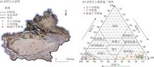
Fig. 1
Sampling points in the study area and soil texture triangle diagram"
Tab. 1
Climate of the sample site"
| 样地分类 | MAP/mm | MAT/℃ | AI |
|---|---|---|---|
| 半干旱样地 | 307.20±11.43 | 0.35±0.85 | 0.31±0.08 |
| 干旱样地 | 140.13±9.81 | 4.82±0.78 | 0.10±0.04 |
| 极端干旱样地 | 34.00±10.73 | 10.49±0.80 | 0.018±0.005 |
Tab. 2
Classification standards of particle size parameters"
| 标准偏差( | 偏度( | 峰度( | |||||
|---|---|---|---|---|---|---|---|
| 分选级别 | 取值范围 | 偏度等级 | 取值范围 | 峰度等级 | 取值范围 | ||
| 极好 | 极负偏 | 很宽平 | |||||
| 好 | 负偏 | 宽平 | |||||
| 较好 | 近于对称 | 中等 | |||||
| 中等 | 正偏 | 尖窄 | |||||
| 较差 | 极正偏 | 很尖窄 | |||||
| 差 | 极尖窄 | ||||||
| 极差 | |||||||
Tab. 3
Descriptive statistics of soil particle composition in plots under different aridity gradients"
| 样地分类 | 黏粒/% | 粉粒/% | 砂粒/% | ||||
|---|---|---|---|---|---|---|---|
| 极细砂 | 细砂 | 中砂 | 粗砂 | 总量 | |||
| 半干旱样地 | 5.33±0.39a | 85.17±1.158a | 8.19±0.81c | 1.32±0.29b | 0.57±0.47a | 0.22±0.02a | 9.50±1.05c |
| 干旱样地 | 5.34±0.44a | 72.63±2.87b | 14.34±1.38b | 7.09±1.78b | 0.97±0.74a | 0.02±0.01a | 21.99±3.16b |
| 极端干旱样地 | 2.35±0.96b | 43.20±7.79c | 30.07±3.95a | 23.41±5.87a | 0.52±0.29a | 0.02±0.01a | 54.45±8.48a |
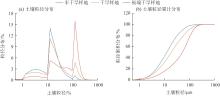
Fig. 2
Particle size distributions in plots under different aridity gradients"
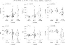
Fig. 3
Soil particle size parameters in plots under different aridity gradients"

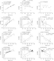
Fig. 4
Relationship between the proportion of soil particle sizes and the fractal dimension in different plots"

Tab. 4
Differences in soil particle composition under different soil-forming parent materials"
| 母质类型 | 样本数 | 黏粒占比/% | 粉粒占比/% | 砂粒占比/% | 分形维数 |
|---|---|---|---|---|---|
| 坡、残积母质 | 102 | 5.32±0.42a | 75.31±3.17a | 19.37±3.40b | 2.45±0.03a |
| 洪、冲积母质 | 48 | 4.69±3.25a | 72.98±3.80a | 22.24±4.38b | 2.37±0.06a |
| 风积母质 | 21 | 1.07±1.65b | 24.63±7.41b | 74.29±7.97a | 2.01±0.15b |
| 黄土状母质 | 9 | 5.03±1.00a | 77.70±2.94a | 17.27±3.65b | 2.44±0.04a |
Tab. 5
Differences in soil particle composition under different soil types"
| 土壤类型 | 样本数 | 黏粒占比/% | 粉粒占比/% | 砂粒占比/% | 分形维数 |
|---|---|---|---|---|---|
| 风沙土 | 24 | 0.91±0.53b | 25.65±9.18c | 73.44±9.69a | 2.00±0.34b |
| 黑钙土 | 24 | 5.71±0.47a | 85.24±1.89a | 9.05±1.65bc | 2.47±0.05a |
| 黑毡土 | 9 | 6.20±0.53a | 87.16±0.82a | 6.64±0.55c | 2.49±0.03a |
| 冷钙土 | 9 | 4.55±0.9ab | 79.93±5.00ab | 15.52±9.01bc | 2.43±0.02a |
| 粟钙土 | 33 | 4.91±0.59ab | 78.72±2.97ab | 16.36±3.37bc | 2.45±0.02a |
| 盐土 | 15 | 3.88±1.15ab | 75.89±5.99ab | 20.23±6.87bc | 2.35±0.08a |
| 棕钙土 | 18 | 5.65±1.18a | 72.55±5.32b | 21.58±6.49bc | 2.47±0.03a |
| 棕漠土 | 24 | 6.32±1.16a | 64.27±4.31b | 29.41±5.27b | 2.46±0.09a |
Tab. 6
Differences in soil particle composition under different land use methods"
| 土地利用方式 | 样本数 | 黏粒占比/% | 粉粒占比/% | 砂粒占比/% | 分形维数 |
|---|---|---|---|---|---|
| 草地 | 123 | 4.85±0.42a | 71.29±20.28a | 23.85±3.45b | 2.42±0.03a |
| 林地 | 30 | 5.00±0.50a | 82.31±5.53a | 12.69±1.98b | 2.44±0.06a |
| 未利用土地 | 27 | 3.30±1.43a | 43.17±31.59b | 53.53±11.73a | 2.09±0.41b |
Tab. 7
Environmental characteristics in plots under different aridity gradients"
| 样地分类 | ASL/m | 坡度 | 坡向 | BD/g·cm-3 | SWC/% |
|---|---|---|---|---|---|
| 半干旱样地 | 1994.33±161.92a | 7.46±1.21a | 175.66±27.70a | 82.91±6.74b | 23.76±3.46a |
| 干旱样地 | 1758.58±194.67ab | 4.22±0.87b | 175.75±22.50a | 119.01±6.51a | 8.75±1.88b |
| 极端干旱样地 | 1195.86±184.51b | 2.03±0.97b | 229.82±31.80a | 134.00±4.76a | 4.05±1.70c |
| 样地分类 | SOM/g·kg-1 | pH | EC/μS·cm-1 | NDVI | 风速/m·s-1 |
| 半干旱样地 | 99.85±11.98a | 6.68±0.26b | 146.47±16.42b | 0.51±0.04a | 10.46±0.88a |
| 干旱样地 | 29.41±7.35b | 8.23±0.11a | 3813.46±1692.26a | 0.21±0.03b | 10.69±0.59a |
| 极端干旱样地 | 7.96±4.24c | 8.52±0.31a | 3625.83±1122.65a | 0.14±0.03b | 9.14±0.44a |

Fig. 5
Factor detection results"
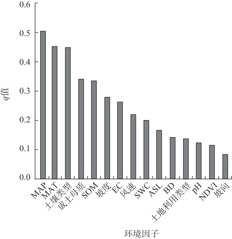
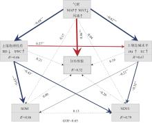
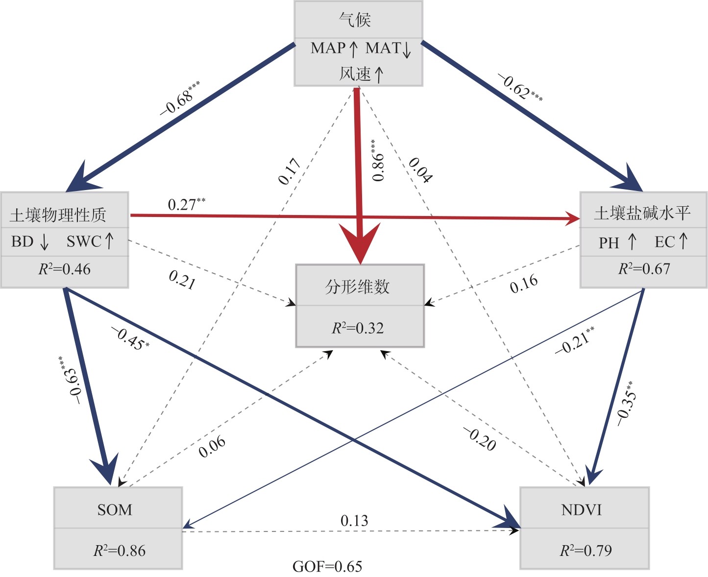
Fig. 6
SEM of the driving effect of different environmental factors on the fractal dimension characteristics of soil particle size"
Tab. 8
Pearson correlation analysis between different environmental factors and fractal dimension"
| 驱动因子 | MAP | MAT | ASL | 坡度 | 坡向 | BD | SWC | SOM | pH | EC | NDVI | 风速 | 分形维数 |
|---|---|---|---|---|---|---|---|---|---|---|---|---|---|
| MAP | 1.00 | - | - | - | - | - | - | - | - | - | - | - | - |
| MAT | -0.68** | 1.00 | - | - | - | - | - | - | - | - | - | - | - |
| ASL | 0.20 | -0.73** | 1.00 | - | - | - | - | - | - | - | - | - | - |
| 坡度 | 0.45** | -0.60** | 0.58** | 1.00 | - | - | - | - | - | - | - | - | - |
| 坡向 | -0.19 | 0.66** | -0.019 | 0.033 | 1.00 | - | - | - | - | - | - | - | - |
| BD | -0.61** | 0.56** | -0.42** | -0.58** | 0.089 | 1.00 | - | - | - | - | - | - | - |
| SWC | 0.66** | -0.61** | 0.44** | -0.54** | -0.14 | -0.84** | 1.00 | - | - | - | - | - | - |
| SOM | 0.75** | -0.67** | 0.38** | -0.64** | -0.15 | -0.84** | 0.88** | 1.00 | - | - | - | - | - |
| pH | -0.79** | 0.59** | -0.21** | -0.47** | 0.012 | 0.71** | -0.70** | -0.79** | 1.00 | - | - | - | - |
| EC | -0.33* | -0.43** | -0.23 | -0.30* | 0.11 | 0.05 | -0.12 | -0.24 | 0.21 | 1.00 | - | - | - |
| NDVI | 0.75** | -0.61** | 0.31* | -0.57** | -0.029 | -0.81** | 0.79** | 0.84** | -0.81** | -0.22 | 1.00 | - | - |
| 风速 | 0.17 | -0.20 | -0.09 | -0.09 | 0.03 | 0.05 | 0.001 | 0.071 | -0.16 | -0.18 | -0.10 | 1.00 | - |
| 分形维数 | 0.42** | -0.45** | 0.12 | 0.16 | -0.10 | -0.12 | 0.16 | 0.24 | -0.26* | -0.10 | 0.16 | 0.29* | 1.00 |
| [1] | 徐加盼, 李继洪, 魏玉杰, 等. 不同母质类型发育土壤颗粒组成分形特征[J]. 土壤学报, 2020, 57(5): 1197-1205. |
| [Xu Jiapan, Li Jihong, Wei Yujie, et al. Fractal characteristics of particle composition for soils developed from different parent materials[J]. Acta Pedologica Sinica, 2020, 57(5): 1197-1205.] | |
| [2] |
张世文, 张立平, 袁君, 等. 基于分形理论和地质统计学的表层土壤颗粒大小分布变化特征[J]. 中国农业科学, 2014, 47(13): 2591-2601.
doi: 10.3864/j.issn.0578-1752.2014.13.011 |
| [Zhang Shiwen, Zhang Liping, Yuan Jun, et al. Characterizing variation of topsoil particle size distribution based on fractal theory and geostatistics[J]. Scientia Agricultura Sinica, 2014, 47(13): 2591-2601.] | |
| [3] |
Mandelbrot B. How long is the coast of Britain? Statistical self similarity and fractional dimension[J]. Science, 1967, 156(3775): 636-638.
pmid: 17837158 |
| [4] |
Tyler S W, Wheatcraft S W. Fractal scaling of soil particle-size distributions: Analysis and limitations[J]. Soil Science Society of America Journal, 1992, 56(2): 362-369.
doi: 10.2136/sssaj1992.03615995005600020005x |
| [5] | 贾重建, 卢瑛, 吴刚, 等. 广东罗浮山土壤颗粒分形维数分布特征[J]. 土壤通报, 2022, 53(5): 1049-1055. |
| [Jia Chongjian, Lu Ying, Wu Gang, et al. Fractal features of particle-size distribution of soil profiles in Luofu Mountain, Guangdong[J]. Chinese Journal of Soil Science, 2022, 53(5): 1049-1055.] | |
| [6] | 杜丹丹, 高瑞忠, 贾德彬. 吉兰泰盐湖盆地土壤颗粒分形特征与空间变异分析[J]. 水土保持研究, 2023, 30(6): 93-101. |
| [Du Dandan, Gao Ruizhong, Jia Debin. Analysis of fractal characteristics and spatial variability of soil particles in the Jilantai Salt Lake Basin[J]. Research of Soil and Water Conservation, 2023, 30(6): 93-101.] | |
| [7] | 吕圣桥, 高鹏, 耿广坡, 等. 黄河三角洲滩地土壤颗粒分形特征及其与土壤有机质的关系[J]. 水土保持学报, 2011, 25(6): 134-138. |
| [Lü Shengqiao, Gao Peng, Geng Guangpo, et al. Characteristics of soil particles and their correlation with soil organic matter in lowlands of the Yellow River Delta[J]. Journal of Soil and Water Conservation, 2011, 25(6): 134-138.] | |
| [8] |
黄业芸, 邱开阳, 朱亚超, 等. 贺兰山不同海拔植被生物量与土壤分形特征和土壤水分的相关关系[J]. 草业学报, 2023, 32(12): 24-35.
doi: 10.11686/cyxb2023050 |
|
[Huang Yeyun, Qiu Kaiyang, Zhu Yachao, et al. Correlation between vegetation biomass and soil fractal characteristics and soil moisture at different elevations in the Helan Mountains[J]. Acta Prataculturae Sinica, 2023, 32(12): 24-35.]
doi: 10.11686/cyxb2023050 |
|
| [9] | 赵守强, 迟大群, 贾付诚, 等. 不同地区盐渍土土壤颗粒的分形特征[J]. 江苏农业科学, 2021, 49(6): 203-207. |
| [Zhao Shouqiang, Chi Daqun, Jia Fucheng, et al. Fractal characteristics of soil particles in saline soils in different regions[J]. Jiangsu Agricultural Sciences, 2021, 49(6): 203-207.] | |
| [10] |
周雷, 曲潇琳, 周涛, 等. 宁夏土壤颗粒组成特点及其影响因素分析[J]. 中国农业科学, 2023, 56(21): 4272-4287.
doi: 10.3864/j.issn.0578-1752.2023.21.011 |
|
[Zhou Lei, Qu Xiaolin, Zhou Tao, et al. Analysis of the characteristics and influencing factors of soil particle composition in Ningxia[J]. Scientia Agricultura Sinica, 2023, 56(21): 4272-4287.]
doi: 10.3864/j.issn.0578-1752.2023.21.011 |
|
| [11] |
刘全渝, 李从娟, 李桂真. 添加膨润土对风蚀沙化土壤理化性质及植被生长的影响[J]. 干旱区研究, 2025, 42(3): 456-466.
doi: 10.13866/j.azr.2025.03.06 |
|
[Liu Quanyu, Li Congjuan, Li Guizhen. Effects of addition of the bentonite on the physicochemical properties and vegetation growth of wind-eroded sandy soil[J]. Arid Zone Research, 2025, 42(3): 456-466.]
doi: 10.13866/j.azr.2025.03.06 |
|
| [12] |
贺郝钰, 刘蔚, 常宗强, 等. 沙区生物土壤结皮演替对表层土壤养分和微生物群落组成的影响[J]. 干旱区地理, 2024, 47(10): 1724-1734.
doi: 10.12118/j.issn.1000-6060.2024.322 |
|
[He Haoyu, Liu Wei, Chang Zongqiang, et al. Effects of biological soil crust succession on soil nutrients, microbial community composition in desert regions[J]. Arid Land Geography, 2024, 47(10): 1724-1734.]
doi: 10.12118/j.issn.1000-6060.2024.322 |
|
| [13] | 王会静, 郭玉川, 白运保, 等. 新疆植被动态格局及其对气候的时滞效应[J]. 农业工程学报, 2023, 39(11): 137-145. |
| [Wang Huijing, Guo Yuchuan, Bai Yunbao, et al. Dynamic pattern of vegetation in Xinjiang and its time-lag effect on climate[J]. Transactions of the Chinese Society of Agricultural Engineering (Transactions of the CSAE), 2023, 39(11): 137-145.] | |
| [14] |
宋小龙, 李陇堂, 任婕, 等. 西北干旱生态地理区NDVI时空变化特征及其驱动力[J]. 干旱区地理, 2025, 48(6): 951-962.
doi: 10.12118/j.issn.1000-6060.2024.548 |
|
[Song Xiaolong, Li Longtang, Ren Jie, et al. Spatio-temporal variation characteristics and driving factors of NDVI in the arid and semi-arid region of northwest China[J]. Arid Land Geography, 2025, 48(6): 951-962.]
doi: 10.12118/j.issn.1000-6060.2024.548 |
|
| [15] | 刁二龙, 曹广超, 曹生奎, 等. 不同尺度下土壤粒径及分形特征[J]. 水土保持研究, 2024, 31(5): 212-220. |
| [Diao Erlong, Cao Guang-chao, Cao Shengkui, et al. Soil particle size and fractal characteristics at different scales[J]. Research of Soil and Water Conservation, 2024, 31(5): 212-220.] | |
| [16] | Udden J A. The mechanical composition of wind deposits[M]. Rock Island: Lutheran Augustana Book Concern, 1898: 1-69. |
| [17] | Krumbein W C. Size frequency distributions of sediments[J]. SEPM Journal of Sedimentary Research, 1934, 4(2): 65-77. |
| [18] | 张永成, 王洪辉, 谭桂花. 基于Excel VBA的图解粒度参数计算[J]. 成都理工大学学报(自然科学版), 2010, 37(6): 650-653. |
| [Zhang Yongcheng, Wang Honghui, Tan Guihua. Graphical calculation for grain size parameters by Excel VBA method[J]. Journal of Chengdu University of Technology (Science & Technology Edition), 2010, 37(6): 650-653.] | |
| [19] |
Folk R L, Ward W C. Brazos River bar: A study in the significance of grain size parameters[J]. Journal of Sedimentary Research, 1957, 27(1): 3-26.
doi: 10.1306/74D70646-2B21-11D7-8648000102C1865D |
| [20] |
罗玉红, 黄予姝, 珠娜, 等. 锡林郭勒盟典型草原区草地开垦及退耕造林对土壤粒径分布和养分的影响[J]. 中国农业科学, 2024, 57(24): 4919-4932.
doi: 10.3864/j.issn.0578-1752.2024.24.008 |
| [Luo Hongyu, Huang Yushu, Zhu Na, et al. Effects of cultivation and cropland afforestation on soil particle-size distribution and soil nutrients in the typical steppe of Xil-ingol League[J]. Scientia Agricultura Sinica, 2024, 57(24): 4919-4932.] | |
| [21] | 王国梁, 周生路, 赵其国. 土壤颗粒的体积分形维数及其在土地利用中的应用[J]. 土壤学报, 2005, 42(4): 545-550. |
| [Wang Guoliang, Zhou Shenglu, Zhao Qiguo. Volume fractal dimension of soil particles and its applications to land use[J]. Acta Pedologica Sinica, 2005, 42(4): 545-550.] | |
| [22] | 宛倩, 王杰, 王向涛, 等. 青藏高原不同草地利用方式对土壤粒径分形特征的影响[J]. 生态学报, 2022, 42(5): 1716-1726. |
| [Wan Qian, Wang Jie, Wang Xiangtao, et al. Effets of different meadow use types on the fractal characteristics of soil particle in the Qinghai-Xizang Plateau[J]. Acta Ecologica Sinica, 2022, 42(5): 1716-1726.] | |
| [23] |
Yan W, Angerer L, Birle E, et al. A graph-based approach for modeling the soil-water retention curve of granular soils across the entire suction range[J]. Acta Geotechnica, 2024, 19(8): 5545-5560.
doi: 10.1007/s11440-023-02166-y |
| [24] |
陈京平, 余子莹, 杨帆, 等. 塔克拉玛干沙漠腹地沙尘暴和地表沙物质粒度特征[J]. 中国沙漠, 2023, 43(2): 150-158.
doi: 10.7522/j.issn.1000-694X.2022.00112 |
|
[Chen Jingping, Yu Ziying, Yang Fan, et al. Particle size characteristics of sandstorm and surface sand at Tazhong area of Taklimakan Desert, China[J]. Journal of Desert Research, 2023, 43(2): 150-158.]
doi: 10.7522/j.issn.1000-694X.2022.00112 |
|
| [25] |
Mitchell P J, O’Grady A P, Pinkard E A, et al. An ecoclimatic framework for evaluating the resilience of vegetation to water deficit[J]. Global Change Biology, 2016, 22(5): 1677-1689.
doi: 10.1111/gcb.13177 pmid: 26643922 |
| [26] | 刘云鹏, 王国栋, 张社奇, 等. 陕西4种土壤粒径分布的分形特征研究[J]. 西北农林科技大学学报(自然科学版), 2003, 31(2): 92-94. |
| [Liu Yunpeng, Wang Guodong, Zhang Sheqi, et al. Fractal characteristics of particle-size distribution for four kinds of soil sa-mples in Shaanxi[J]. Journal of Northwest A & F University (Natural Science Edition), 2003, 31(2): 92-94.] | |
| [27] | 杨培岭, 罗远培, 石元春. 用粒径的重量分布表征的土壤分形特征[J]. 科学通报, 1993, 38(20): 1896-1899. |
| [Yang Peiling, Luo Yuanpei, Shi Yuanchun. The fractal characteristics of soil characterized by the weight distribution of particle size[J]. Chinese Science Bulletin, 1993, 38(20): 1896-1899.] | |
| [28] | 杨娟, 高永, 王瑞东, 等. 沙质草原风蚀坑土壤粒度组成及养分特征[J]. 中国农业科技导报, 2024, 26(10): 186-194. |
| [Yang Juan, Gao Yong, Wang Ruidong, et al. Soil particle composition and nutrient characteristics of wind erosion pits in sandy grassland[J]. Journal of Agricultural Science and Technology, 2024, 26(10): 186-194.] | |
| [29] |
刘茜雅, 王海兵, 左合君, 等. 苏宏图戈壁沉积物分形空间变异性及其成因[J]. 干旱区地理, 2021, 44(1): 168-177.
doi: 10.12118/j.issn.1000–6060.2021.01.18 |
|
[Liu Xiya, Wang Haibing, Zuo Hejun, et al. Fractal spatial variability and its genesis of sediments in Suhongtu gobi[J]. Arid Land Geography, 2021, 44(1): 168-177.]
doi: 10.12118/j.issn.1000–6060.2021.01.18 |
|
| [30] | 段晓明, 夏栋, 马悦阳, 等. 不同生态修复方式对土壤团聚体稳定性及胶结物质的影响[J]. 生态学报, 2025, 45(11): 5178-5190. |
| [Duan Xiaoming, Xia Dong, Ma Yueyang, et al. Effect of different restoration approaches of engineering disturbance slopes on bonding materials and stability of soil aggregate[J]. Acta Ecologica Sinica, 2025, 45(11): 5178-5190.] | |
| [31] |
杜雅仙, 樊瑾, 李诗瑶, 等. 荒漠草原不同植被微斑块土壤粒径分布分形特征与养分的关系[J]. 应用生态学报, 2019, 30(11): 3716-3724.
doi: 10.13287/j.1001-9332.201911.004 |
|
[Du Yaxian, Fan Jin, Li Shiyao, et al. Fractal dimension characteristics of soil particle size distribution under different vegetation patches in desert steppe and its relationship with soil nutrients[J]. Chinese Journal of Applied Ecology, 2019, 30(11): 3716-3724.]
doi: 10.13287/j.1001-9332.201911.004 |
|
| [32] |
Delgado-Baquerizo M, Maestre F T, Gallardo A, et al. Decoupling of soil nutrient cycles as a function of aridity in global drylands[J]. Nature, 2013, 502(7473): 672-676.
doi: 10.1038/nature12670 |
| [33] |
郭玉琳, 赵勇, 周雅蔓, 等. 新疆天山山区夏季降水日变化特征及其与海拔高度关系[J]. 干旱区地理, 2022, 45(1): 57-65.
doi: 10.12118/j.issn.1000–6060.2021.057 |
|
[Guo Yulin, Zhao Yong, Zhou Yaman, et al. Diurnal variation of summer precipitation and its relationship with altitude in Tianshan Mountains of Xinjiang[J]. Arid Land Geography, 2022, 45(1): 57-65.]
doi: 10.12118/j.issn.1000–6060.2021.057 |
|
| [34] | Certini G, Scalenghe R. The crucial interactions between climate and soil[J]. Science of the Total Environment, 2023, 856(2): 159-169. |
|
||