Arid Land Geography ›› 2025, Vol. 48 ›› Issue (12): 2169-2182.doi: 10.12118/j.issn.1000-6060.2025.090
• Land Use and Carbon Cycle • Previous Articles Next Articles
NIU Feifei1,2( ), GUO Jing3, LUO Jie4, GOU Xueping1,2, LIU Xuewei1,2, ZHANG Renping1,2()
Received:2025-02-24
Revised:2025-04-11
Online:2025-12-25
Published:2025-12-30
Contact:
ZHANG Renping
E-mail:niufeifei@stu.xju.edu.cn;zhrp@xju.edu.cn
NIU Feifei, GUO Jing, LUO Jie, GOU Xueping, LIU Xuewei, ZHANG Renping. Simulation of land use change and prediction of carbon storage in Xinjiang based on GeoSOS-FLUS and InVEST models[J].Arid Land Geography, 2025, 48(12): 2169-2182.
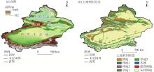
Fig. 1
Schematic diagram of the study area"
Tab. 1
Data sources"
| 数据类型 | 数据名称 | 格式 | 分辨率 | 数据来源 |
|---|---|---|---|---|
| LUCC | 土地利用数据 | 栅格 | 1 km | 地球资源数据云平台( |
| 地形 | 高程 | 栅格 | 90 m | |
| 坡度 | 栅格 | 90 m | ||
| 坡向 | 栅格 | 90 m | ||
| 植被 | 植被覆盖率 | 栅格 | 1 km,300 m | |
| 气象数据 | 年均气温 | 栅格 | 1 km | |
| 年均降水 | 栅格 | 1 km | | |
| 社会经济数据 | 年GDP | 栅格 | 1 km | |
| 人口密度 | 栅格 | 1 km | | |
| 区位因素数据 | 距河流、铁路、道路、城镇、市中心、高速的距离 | 栅格 | 30 m | |
Tab. 2
Weight of neighborhood for each land use type in Xinjiang"
| 指标 | 耕地 | 林地1 | 林地2 | 草地1 | 草地2 | 水域 | 建设用地 | 未利用地 |
|---|---|---|---|---|---|---|---|---|
| 领域因子 | 0.5 | 0.7 | 0.5 | 0.6 | 0.4 | 0.4 | 0.8 | 0.1 |
Tab. 3
Matrix of land use transfer under 3 scenarios in the study area"
| 土地利 用类型 | 自然发展情景(DAU) | 生态优先情景(EPS) | 快速发展情景(RDS) | |||||||||||||||||||||||
|---|---|---|---|---|---|---|---|---|---|---|---|---|---|---|---|---|---|---|---|---|---|---|---|---|---|---|
| a | b | c | d | e | f | g | h | a | b | c | d | e | f | g | h | a | b | c | d | e | f | g | h | |||
| a | 1 | 1 | 1 | 1 | 1 | 1 | 1 | 1 | 1 | 1 | 1 | 1 | 1 | 1 | 1 | 1 | 1 | 0 | 0 | 0 | 1 | 1 | 1 | 0 | ||
| b | 1 | 1 | 1 | 1 | 1 | 1 | 1 | 1 | 0 | 1 | 0 | 0 | 0 | 0 | 0 | 1 | 0 | 1 | 0 | 0 | 0 | 1 | 0 | 0 | ||
| c | 1 | 1 | 1 | 1 | 1 | 1 | 1 | 1 | 0 | 1 | 1 | 0 | 0 | 0 | 0 | 1 | 1 | 1 | 1 | 0 | 0 | 1 | 1 | 0 | ||
| d | 1 | 1 | 1 | 1 | 1 | 1 | 1 | 1 | 0 | 1 | 1 | 1 | 0 | 1 | 0 | 1 | 0 | 1 | 1 | 1 | 0 | 1 | 0 | 0 | ||
| e | 1 | 1 | 1 | 1 | 1 | 1 | 1 | 1 | 0 | 1 | 1 | 1 | 1 | 1 | 0 | 1 | 1 | 1 | 1 | 1 | 1 | 1 | 1 | 0 | ||
| f | 1 | 1 | 1 | 1 | 1 | 1 | 1 | 1 | 0 | 1 | 1 | 0 | 0 | 1 | 0 | 1 | 0 | 1 | 0 | 0 | 0 | 1 | 1 | 0 | ||
| g | 0 | 0 | 0 | 0 | 0 | 0 | 1 | 0 | 0 | 0 | 0 | 0 | 0 | 0 | 1 | 1 | 0 | 0 | 0 | 0 | 0 | 1 | 1 | 0 | ||
| h | 1 | 1 | 1 | 1 | 1 | 1 | 1 | 1 | 1 | 1 | 1 | 1 | 1 | 1 | 1 | 1 | 1 | 1 | 1 | 1 | 1 | 1 | 1 | 1 | ||
Tab. 4
Carbon density data of land use types in Xinjiang /t·hm-2"
| 土地利用类型 | 地上生物碳密度 | 地下生物碳密度 | 土壤碳 密度 | 死亡有机物碳密度 |
|---|---|---|---|---|
| 耕地 | 2.90 | 3.44 | 76.6 | 1.24 |
| 林地1 | 30.89 | 9.12 | 107.82 | 2.48 |
| 林地2 | 10.76 | 2.05 | 67.73 | 0.98 |
| 草地1 | 1.49 | 4.29 | 75.54 | 0.22 |
| 草地2 | 0.47 | 1.42 | 24.69 | 0.05 |
| 水域 | 0.64 | 0.45 | 0.00 | 0.00 |
| 建设用地 | 2.26 | 1.45 | 0.00 | 0.00 |
| 未利用地 | 0.45 | 0.87 | 38.55 | 0.00 |
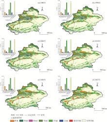
Fig. 2
Spatial distribution and proportion of land uses from 1980 to 2022"
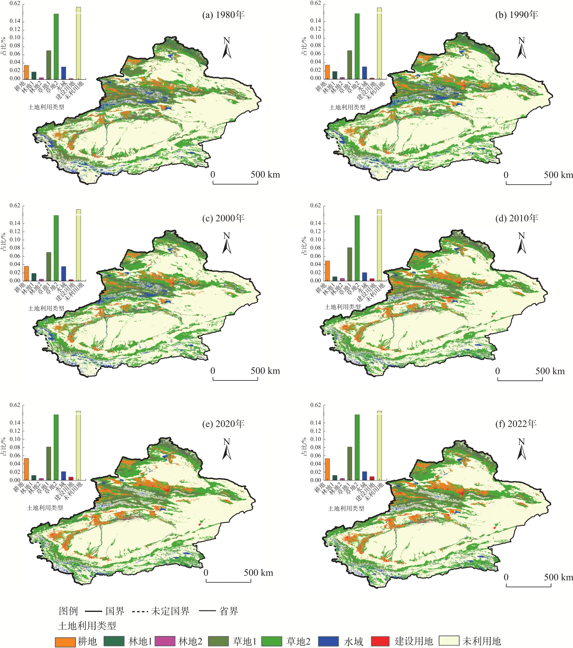
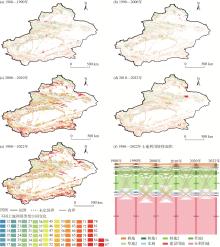
Fig. 3
Land use transfer and spatial change from 1980 to 2022"

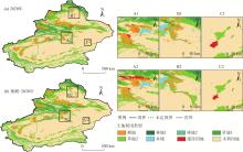
Fig. 4
Comparison of predicted land use data and real data in 2020"
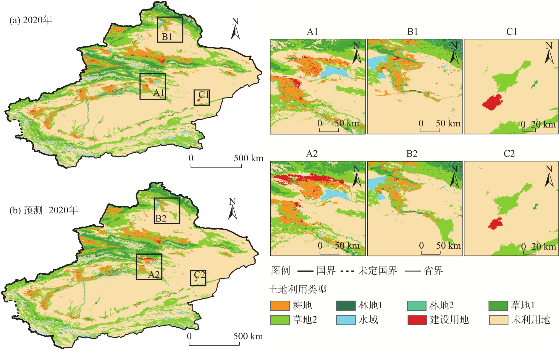
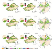
Fig. 5
Spatial changes of land under different scenarios in 2030 and 2060"
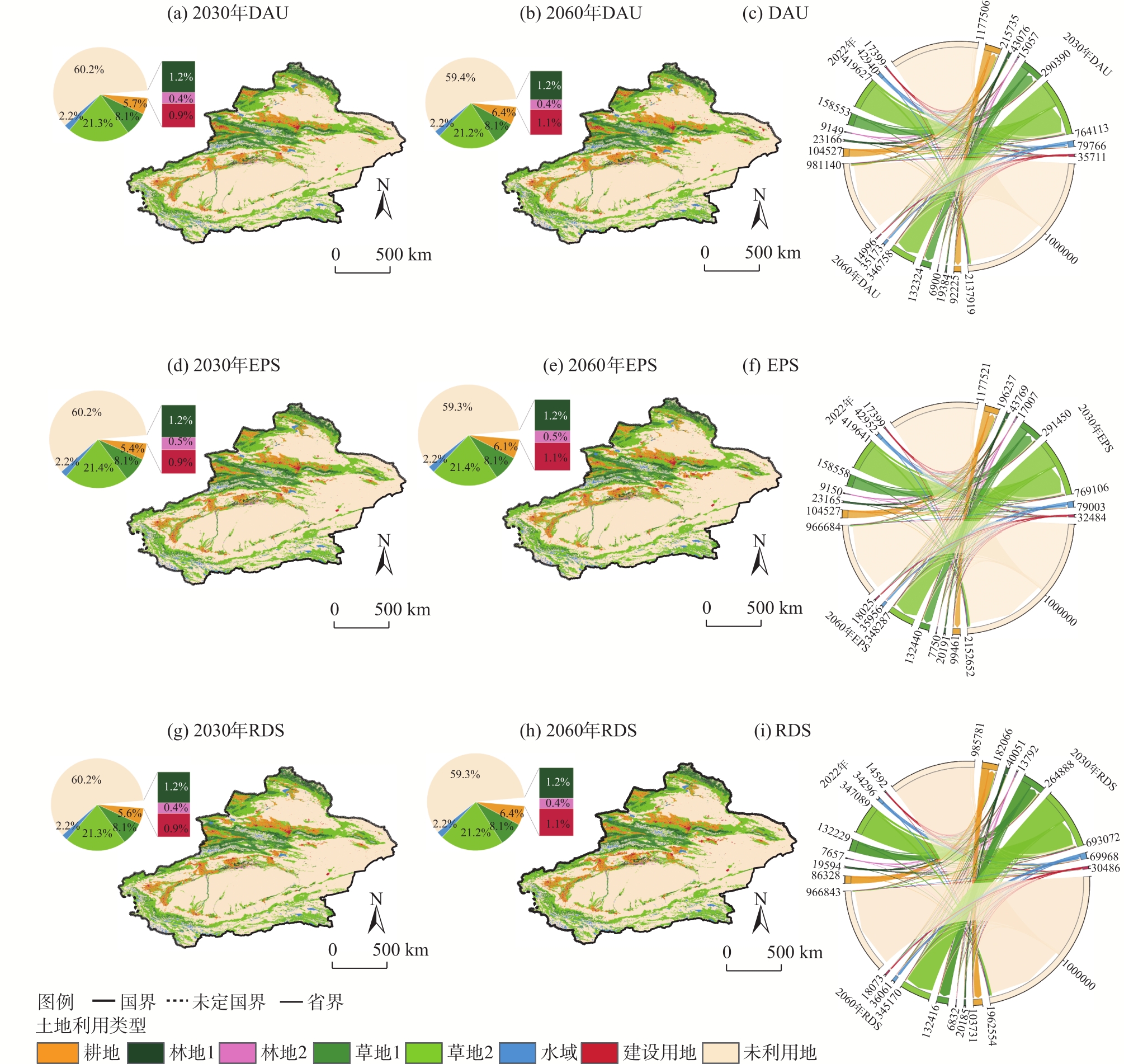
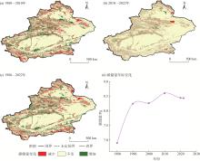
Fig. 6
Changes in carbon stocks from 1980 to 2022"
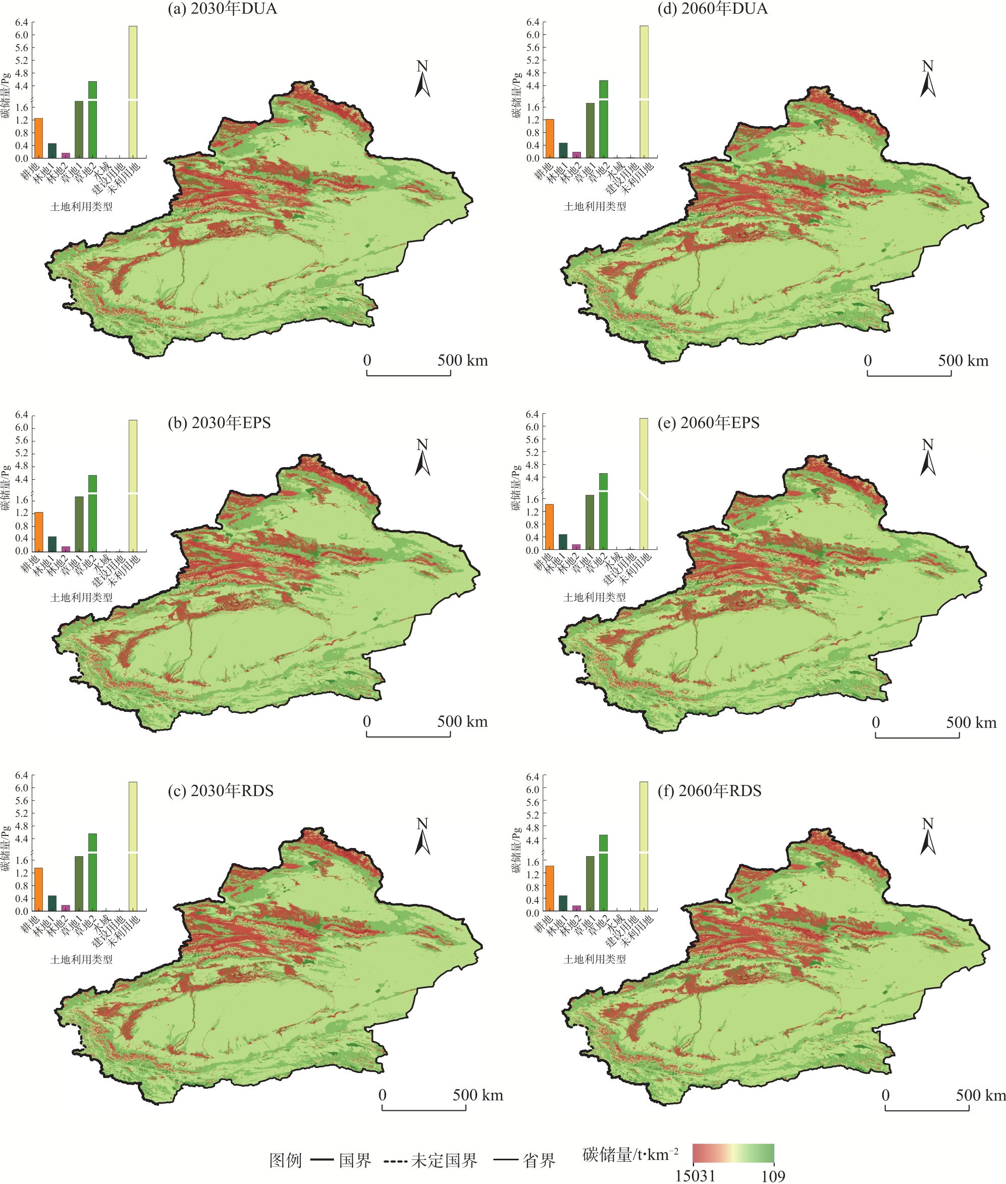
Fig. 7
Prediction of carbon stocks under three scenarios in 2030 and 2060"
| [1] |
Wang H, Zhou S L, Li X B, et al. The influence of climate change and human activities on ecosystem service value[J]. Ecological Engineering, 2016, 87: 224-239.
doi: 10.1016/j.ecoleng.2015.11.027 |
| [2] |
Cai B F, Zhang L, Lei Y, et al. A deeper understanding of the CO2 emission pathway under China’s carbon emission peak and carbon neutrality goals[J]. Engineering, 2023, 30: 27-29.
doi: 10.1016/j.eng.2022.06.014 |
| [3] | Guo W, Teng Y J, Li J, et al. A new assessment framework to forecast land use and carbon storage under different SSP-RCP scenarios in China[J]. Science of the Total Environment, 2024, 912: 169088, doi: 10.1016/j.scitotenv.2023.169088. |
| [4] | Chang X Q, Xing Y Q, Wang J Q, et al. Effects of land use and cover change (LUCC) on terrestrial carbon stocks in China between 2000 and 2018[J]. Resources, Conservation and Recycling, 2022, 182: 106333, doi: 10.1016/j.resconrec.2022.106333. |
| [5] | Zhang J T, Yang K, Wu J D, et al. Scenario simulation of carbon balance in carbon peak pilot cities under the background of the “dual carbon” goals[J]. Sustainable Cities and Society, 2024, 116: 105910, doi: 10.1016/j.scs.2024.105910. |
| [6] | 赵佳俊, 侯鹏, 陈妍. 中国草地植被碳储量估算研究进展[J]. 生态学杂志, 2025, 44(5): 1678-1687. |
|
[Zhao Jiajun, Hou Peng, Chen yan. Research progress on the estimation of vegetation carbon storage of grasslands in China[J]. Chinese Journal of Ecology, 2025, 44(5): 1678-1687.]
doi: 10.13292/j.1000-4890.202505.044 |
|
| [7] |
Zhu E Y, Deng J S, Zhou M M, et al. Carbon emissions induced by land-use and land-cover change from 1970 to 2010 in Zhejiang, China[J]. Science of the Total Environment, 2019, 646: 930-939.
doi: 10.1016/j.scitotenv.2018.07.317 |
| [8] | 孔君洽, 杨荣, 苏永中, 等. 基于土地利用/覆被变化的荒漠绿洲碳储量动态评估[J]. 生态学报, 2018, 38(21): 7801-7812. |
| [Kong Junqia, Yang Rong, Su Yongzhong, et al. Effect of land use and cover change on carbon stock dynamics in a typical desert oasis[J]. Acta Ecologica Sinica, 2018, 38(21): 7801-7812.] | |
| [9] | Xu C L, Zhang Q B, Yu Q, et al. Effects of land use/cover change on carbon storage between 2000 and 2040 in the Yellow River Basin, China[J]. Ecological Indicators, 2023, 151: 110345, doi: 10.1016/j.ecolind.2023.110345. |
| [10] | 史名杰, 武红旗, 贾宏涛, 等. 基于MCE-CA-Markov和InVEST模型的伊犁谷地碳储量时空演变及预测[J]. 农业资源与环境学报, 2021, 38(6): 1010-1019. |
| [Shi Mingjie, Wu Hongqi, Jia Hongtao, et al. Temporal and spatial evolution and prediction of carbon stocks in Yili Valley based on MCE-CA-Markov and InVEST models[J]. Journal of Agricultural Resources and Environment, 2021, 38(6): 1010-1019.] | |
| [11] | Song K Y, Cheng W M, Wang B X, et al. Impact of landform on spatial-temporal distribution and scenario-based prediction of carbon stocks in arid regions: A case study of Xinjiang[J]. Catena, 2025, 250: 108781, doi: 10.1016/j.catena.2025.108781. |
| [12] | Li K M, Cao J J, Adamowski J F, et al. Assessing the effects of ecological engineering on spatiotemporal dynamics of carbon storage from 2000 to 2016 in the Loess Plateau area using the InVEST model: A case study in Huining County, China[J]. Environmental Development, 2021, 39: 100641, doi: 10.1016/j.envdev.2021.100641. |
| [13] |
Liu J Y, Kuang W H, Zhang Z X, et al. Spatiotemporal characteristics, patterns, and causes of land-use changes in China since the late 1980s[J]. Journal of Geographical Sciences, 2014, 24(2): 195-210.
doi: 10.1007/s11442-014-1082-6 |
| [14] | Gao H R, Gong J, Liu J K, et al. Effects of land use/cover changes on soil organic carbon stocks in Qinghai-Tibet Plateau: A comparative analysis of different ecological functional areas based on machine learning methods and soil carbon pool data[J]. Journal of Cleaner Production, 2024, 434: 139854, doi: 10.1016/j.jclepro.2023.139854. |
| [15] |
Adelisardou F, Zhao W, Chow R, et al. Spatiotemporal change detection of carbon storage and sequestration in an arid ecosystem by integrating Google Earth Engine and InVEST (the Jiroft plain, Iran)[J]. International Journal of Environmental Science and Technology, 2022, 19(7): 5929-5944.
doi: 10.1007/s13762-021-03676-6 |
| [16] | 雷泽鑫, 罗俊杰, 张文正, 等. LUCC多情景模拟下黄土沟壑区流域径流响应规律及其适应性规划对策——以晋西三川河流域为例[J]. 生态学报, 2024, 45(3): 1090-1101. |
| [Lei Zexin, Luo Junjie, Zhang Wenzheng, et al. Response pattern of watershed runoff in loess gully area under LUCC multi-scenario simulation and its adaptive planning strategy: A case study of Sanchuan River Basin in west of Shanxi Province[J]. Acta Ecologica Sinica, 2024, 45(3): 1090-1101.] | |
| [17] | Yin Y T, Lin G, Li X H, et al. Nature-based solutions still result in unfairness in carbon emissions[J]. Journal of Cleaner Production, 2024, 476: 143691, doi: 10.1016/j.jclepro.2024.143691. |
| [18] | 张凯琪, 陈建军, 侯建坤, 等. 耦合InVEST与GeoSOS-FLUS模型的桂林市碳储量可持续发展研究[J]. 中国环境科学, 2022, 42(6): 2799-2809. |
| [Zhang Kaiqi, Chen Jianjun, Hou Jiankun, et al. Study on sustainable development of carbon storage in Guilin coupled with InVEST and GeoSOS-FLUS model[J]. China Environmental Science, 2022, 42(6): 2799-2809.] | |
| [19] | Gong W F, Duan X Y, Sun Y X, et al. Multi-scenario simulation of land use/cover change and carbon storage assessment in Hainan coastal zone from perspective of free trade port construction[J]. Journal of Cleaner Production, 2023, 385: 135630, doi: 10.1016/j.jclepro.2022.135630. |
| [20] |
秦艳培, 徐少君, 田耀武. 黄河流域河南段植被和土壤及其碳密度空间分异研究[J]. 生态环境学报, 2022, 31(9): 1745-1753.
doi: 10.16258/j.cnki.1674-5906.2022.09.004 |
| [Qin Yanpei, Xu Shaojun, Tian Yaowu. The spatial differentiation of vegetation and soil carbon density in Henan section of the Yellow River Basin[J]. Ecology and Environmental Sciences, 2022, 31(9): 1745-1753.] | |
| [21] |
Spohn M, Bagchi S, Biederman L A, et al. The positive effect of plant diversity on soil carbon depends on climate[J]. Nature Communications, 2023, 14(1): 6624, doi: 10.1038/s41467-023-42340-0.
pmid: 37857640 |
| [22] |
薛晶月, 王丽华, 谢雨, 等. 西南地区草地群落灌木植物盖度对生态系统碳库的影响[J]. 植物生态学报, 2019, 43(4): 365-373.
doi: 10.17521/cjpe.2017.0062 |
|
[Xue Jingyue, Wang Lihua, Xie Yu, et al. Effect of shrub coverage on grassland ecosystem carbon pool in southwestern China[J]. Chinese Journal of Plant Ecology, 2019, 43(4): 365-373.]
doi: 10.17521/cjpe.2017.0062 |
|
| [23] | 王云霓, 曹恭祥, 王彦辉, 等. 宁夏六盘山华北落叶松人工林植被碳密度特征[J]. 林业科学, 2015, 51(10): 10-16. |
| [Wang Yunni, Cao Gongxiang, Wang Yanhui, et al. Characteristics of biomass carbon density of Larix principis-rupprechtii plantation in Liupan Mountains of Ningxia[J]. Scientia Silvae Sinicae, 2015, 51(10): 10-16.] | |
| [24] |
Verburg P H, Crossman N, Ellis E C, et al. Land system science and sustainable development of the earth system: A global land project perspective[J]. Anthropocene, 2015, 12: 29-41.
doi: 10.1016/j.ancene.2015.09.004 |
| [25] |
付玮, 夏文浩, 樊童生, 等. 塔里木河流域生态系统碳储量的情景预测分析[J]. 干旱区地理, 2024, 47(4): 634-647.
doi: 10.12118/j.issn.1000-6060.2023.274 |
|
[Fu Wei, Xia Wenhao, Fan Tongsheng, et al. Scenario projection analysis of ecosystem carbon stocks in the Tarim River Basin[J]. Arid Land Geography, 2024, 47(4): 634-647.]
doi: 10.12118/j.issn.1000-6060.2023.274 |
|
| [26] |
韩楚翘, 郑江华, 王哲, 等. 基于PLUS-InVEST模型吐哈盆地陆地生态系统碳储量时空变化及多情景模拟[J]. 干旱区地理, 2024, 47(2): 260-269.
doi: 10.12118/j.issn.1000-6060.2023.066 |
|
[Han Chuqiao, Zheng Jianghua, Wang Zhe, et al. Spatiotemporal variation and multiscenario simulation of carbon storage in terrestrial ecosystems in the Turpan-Hami Basin based on PLUS-InVEST model[J]. Arid Land Geography, 2024, 47(2): 260-269.]
doi: 10.12118/j.issn.1000-6060.2023.066 |
|
| [27] |
Liu X P, Liang X, Li X, et al. A future land use simulation model (FLUS) for simulating multiple land use scenarios by coupling human and natural effects[J]. Landscape and Urban Planning, 2017, 168: 94-116.
doi: 10.1016/j.landurbplan.2017.09.019 |
| [28] | Shen L, Zeng Q. Multiscenario simulation of land use and land cover in the Zhundong mining area, Xinjiang, China[J]. Ecological Indicators, 2022, 145: 109608, doi: 10.1016/j.ecolind.2022.109608. |
| [29] | 许澳康, 胡梦珺, 石晶, 等. 基于PLUS-InVEST模型的石羊河流域生态系统碳储量时空变化及多情景模拟[J/OL]. 中国环境科学. [2023-12-12]. https://doi.org/10.19674/j.cnki.issn1000-6923.20231211.016. |
| [Xu Aokang, Hu Mengjun, Shi Jing, et al. Spatial and temporal variability of ecosystem carbon storages and multi-scenario simulation based on the PLUS-InVEST model in the Shiyang River Basin[[J/OL]. China Environmental Science. [2023-12-12]. https://doi.org/10.19674/j.cnki.issn1000-6923.20231211.016.] | |
| [30] |
卢雅焱, 徐晓亮, 李基才, 等. 基于InVEST模型的新疆天山碳储量时空演变研究[J]. 干旱区研究, 2022, 39(6): 1896-1906.
doi: 10.13866/j.azr.2022.06.20 |
|
[Lu Yayan, Xu Xiaoliang, Li Jicai, et al. Research on the spatio-temporal variation of carbon storage in the Xinjiang Tianshan Mountains based on the InVEST model[J]. Arid Zone Research, 2022, 39(6): 1896-1906.]
doi: 10.13866/j.azr.2022.06.20 |
|
| [31] | Huang M L, Mamitimin Y, Abulizi A, et al. Integrated assessment of land use and carbon storage changes in the Tulufan-Hami Basin under the background of urbanization and climate change[J]. International Journal of Applied Earth Observation and Geoinformation, 2024, 135: 104261, doi: 10.1016/j.jag.2024.104261. |
| [32] |
匡文慧, 张树文, 杜国明, 等. 2015—2020年中国土地利用变化遥感制图及时空特征分析[J]. 地理学报, 2022, 77(5): 1056-1071.
doi: 10.11821/dlxb202205002 |
|
[Kuang Wenhui, Zhang Shuwen, Du Guoming, et al. Remotely sensed mapping and analysis of spatio-temporal patterns of land use change across China in 2015—2020[J]. Acta Geographica Sinica, 2022, 77(5): 1056-1071.]
doi: 10.11821/dlxb202205002 |
|
| [33] | Zhu G F, Qiu D D, Zhang Z X, et al. Land-use changes lead to a decrease in carbon storage in arid region, China[J]. Ecological Indicators, 2021, 127: 107770, doi: 10.1016/j.ecolind.2021.107770. |
| [34] | 傅楷翔, 贾国栋, 余新晓, 等. 耦合PLUS-InVEST-Geodector模型的新疆地区碳储量时空变化及驱动机制分析[J]. 环境科学, 2024, 45(9): 5416-5430. |
| [Fu Kaixiang, Jia Guodong, Yu Xinxiao, et al. Analysis of temporal and spatial carbon stock changes and driving mechanism in Xinjiang region by coupled PLUS-InVEST-Geodector model[J]. Environmental Science, 2024, 45(9): 5416-5430.] | |
| [35] | 刘洋, 李诚志, 刘志辉, 等. 1982—2013年基于GIMMS-NDVI的新疆植被覆盖时空变化[J]. 生态学报, 2016, 36(19): 6198-6208. |
| [Liu Yang, Li Chengzhi, Liu Zhihui, et al. Assessment of spatio-temporal variations in vegetation cover in Xinjiang from 1982 to 2013 based on GIMMS-NDVI[J]. Acta Ecologica Sinica, 2016, 36(19): 6198-6208.] | |
| [36] | Chen X, Yu L, Hou S, et al. Unraveling carbon stock dynamics and their determinants in China’s Loess Plateau over the past 40 years[J]. Ecological Indicators, 2024, 159: 111760, doi: 10.1016/j.ecolind.2024.111760. |
| [37] | Wu B W, Zhang Y Y, Wang Y, et al. Urbanization promotes carbon storage or not? The evidence during the rapid process of China[J]. Journal of Environmental Management, 2024, 359: 121061, doi: 10.1016/j.jenvman.2024.121061. |
| [38] | 杨顺法, 昝梅, 袁瑞联, 等. 基于 PLUS与 InVEST模型的新疆碳储量变化及预测[J]. 环境科学, 2025, 46(1): 378-387. |
| [Yang Shunfa, Zan Mei, Yuan Ruilian, et al. Carbon stock changes and forecasting in Xinjiang based on PLUS and InVEST model approach[J]. Environmental Science, 2025, 46(1): 378-387.] | |
| [39] |
Villa J A, Bernal B. Carbon sequestration in wetlands, from science to practice: An overview of the biogeochemical process, measurement methods, and policy framework[J]. Ecological Engineering, 2018, 114: 115-128.
doi: 10.1016/j.ecoleng.2017.06.037 |
| [40] | 翟夏杰, 崔丽娟, 李伟, 等. 中国典型湿地生态系统的固碳价值研究[J]. 水生态学杂志, 2024, 45(6): 1-8. |
| [Zhai Xiajie, Cui Lijuan, Li Wei, et al. Carbon sequestration by typical wetland ecosystems in China[J]. Journal of Hydroecology, 2024, 45(6): 1-8.] | |
| [41] | 李瑞明, 周梓欣, 张伟, 等. “十四五”以来新疆煤炭地质工作进展及发展方向[J]. 新疆地质, 2024, 42(1): 7-13. |
| [Li Ruiming, Zhou Zixin, Zhang Wei, et al. The progress and development direction of coal ggeological work in Xinjiang during the 14th Five Year Plan period[J]. Xinjiang Geology, 2024, 42(1): 7-13.] | |
| [42] |
Yang F, Huang J P, Zhou C L, et al. Desert abiotic carbon sequestration weakening by precipitation[J]. Environmental Science & Technology, 2023, 57(18): 7174-7184.
doi: 10.1021/acs.est.2c09470 |
| [43] | 黄子豪, 杜华强, 李雪建, 等. 土地利用/覆盖变化及其对森林碳收支影响研究综述[J]. 遥感学报, 2025, 29(1): 49-69. |
|
[Huang Zihao, Du Huaqiang, Li Xuejian, et al. Review of research on land use/cover change and its impact on forest carbon balance[J]. National Remote Sensing Bulletin, 2025, 29(1): 49-69.]
doi: 10.11834/jrs.20233169 |
|
||