Arid Land Geography ›› 2022, Vol. 45 ›› Issue (6): 1860-1869.doi: 10.12118/j.issn.1000-6060.2022.092
• Earth Information Sciences • Previous Articles Next Articles
WU Quan1( ),YAO Xijun1,CHEN Xiaodong2,ZHAO Min2(),ZHAO Huan2,YUN Hao1
Received:2022-03-09
Revised:2022-05-24
Online:2022-11-25
Published:2023-02-01
Contact:
Min ZHAO
E-mail:651668946@qq.com;617933488@qq.com
WU Quan, YAO Xijun, CHEN Xiaodong, ZHAO Min, ZHAO Huan, YUN Hao. Nondestructive inspection method for soil profile configuration based on ground penetrating radar[J].Arid Land Geography, 2022, 45(6): 1860-1869.
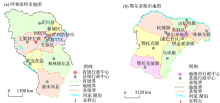
Fig. 1
Plot of the sampling area"


Fig. 2
GER-10 pulsed ground penetrating radar"
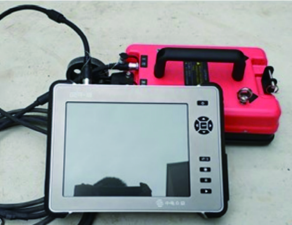
Tab. 1
Technical parameters and indexes of GER-10 pulsed Ground Penetrating Radar"
| 技术参数 | 指标 |
|---|---|
| 最大扫描速度 | 215 Traces.s-1 |
| 采样模式 | 时间模式、距离模式、点测模式 |
| 时间窗范围 | 1~8000 ns |
| 增益范围 | -10~160 dB |
| 中心频率 | 900 MHz |
| 深度范围 | 0.5~1.5 m |
| 耦合方式 | 地面耦合 |

Fig. 3
Image of ground penetrating radar"

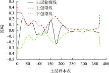
Fig. 4
Abacuses of envelope analysis"
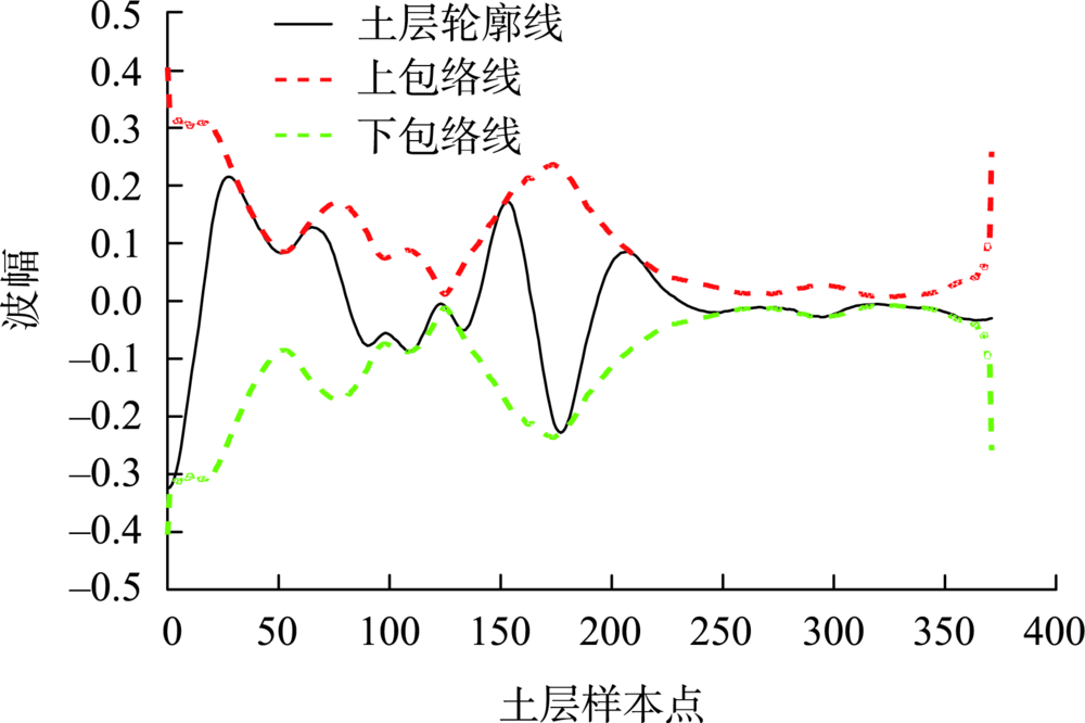
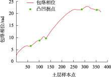
Fig. 5
Instantaneous phase fitting curve and convex and concave inflection point plot"

Tab. 2
Results of soil property testing"
| 所测参数 | 第1层土壤 | 第2层土壤 | 第3层土壤 | 第4层土壤 | 第5层土壤 | |
|---|---|---|---|---|---|---|
| 介电常数 | 测量值/m | 3.41 | 2.86 | 3.15 | 3.45 | 3.44 |
| 计算值/m | 3.62 | 3.11 | 3.43 | 3.78 | 3.75 | |
| 相对误差/% | 6.16 | 8.74 | 8.89 | 9.57 | 9.01 | |
| 层厚 | 测量值/cm | 20.00 | 12.00 | 8.00 | 45.00 | 20.00 |
| 计算值/cm | 21.56 | 12.91 | 8.73 | 48.63 | 21.65 | |
| 相对误差/% | 7.80 | 7.58 | 9.13 | 8.07 | 8.25 | |
| 土壤含水率 | 测量值/% | 4.02 | 2.58 | 3.42 | 4.23 | 4.15 |
| 计算值/% | 4.36 | 2.81 | 3.73 | 4.64 | 4.55 | |
| 相对误差/% | 8.46 | 8.91 | 9.06 | 9.69 | 9.64 | |
| 土壤含砂量 | 计算值/% | 28.27 | 26.35 | 25.14 | 9.25 | 23.21 |
| 图像噪声方差值 | 822.00 | 792.00 | 760.00 | 306.00 | 680.00 | |
| 土质 | 识别结果 | 砂壤土 | 砂壤土 | 砂壤土 | 黏土 | 砂壤土 |
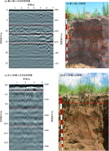
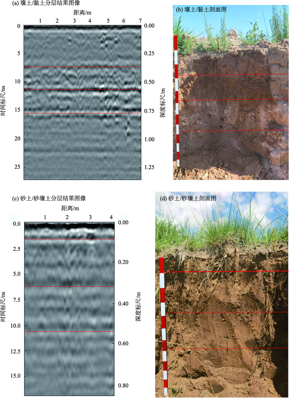
Fig. 6
Comparison image of probe results"
Tab. 3
Soil configuration test results of Tumed Left Banner"
| 区域 | 取得数据方式 | 层数 | 层号 | 层厚/cm | 土质类型 |
|---|---|---|---|---|---|
| 土默特左旗 | 人工采样 | 4 | 1 | 30 | 砂土 |
| 2 | 24 | 砂土 | |||
| 3 | 25 | 砂壤土 | |||
| 4 | >69 | 砂壤土 | |||
| 系统分析 | 4 | 1 | 36 | 砂土 | |
| 2 | 22 | 砂土 | |||
| 3 | 19 | 砂壤土 | |||
| 4 | >75 | 砂壤土 | |||
| 达拉特旗 | 人工采样 | 4 | 1 | 9 | 壤土 |
| 2 | 22 | 壤土 | |||
| 3 | 30 | 黏土 | |||
| 4 | >70 | 黏土 | |||
| 系统分析 | 4 | 1 | 8 | 壤土 | |
| 2 | 27 | 壤土 | |||
| 3 | 24 | 黏土 | |||
| 4 | >65 | 黏土 |
| [1] | 李彬彬, 许明祥, 巩晨, 等. 国际土壤质量研究热点与趋势——基于大数据的Citespace可视化分析[J]. 自然资源学报, 2017, 32(11): 1983-1998. |
| [Li Binbin, Xu Mingxiang, Gong Chen, et al. Hotspots and trends in international soil quality research[J]. Journal of Natural Resources, 2017, 32(11): 1983-1998.] | |
| [2] | 陈国茜, 祝存兄, 李素雲, 等. 三江源地区土壤水分的地理分区遥感模型构建及时空变化[J]. 草地学报, 2021, 29(增刊1): 199-207. |
| [Chen Guoqian, Zhu Cunxiong, Li Suyun, et al. Remote sensing model construction and spatial-temporal changes of soil moisture in the Three-River Headwaters region[J]. Acta Agrestia Sinica, 2021, 29(Suppl. 1): 199-207.] | |
| [3] | 马驰. HJ-1A HSI与Sentinel-2A遥感数据土壤全氮含量反演精度的对比研究[J]. 无线电工程, 2021, 51(12): 1540-1548. |
| [Ma Chi. Accuracy comparison of soil total nitrogen content inversion based on HJ-1A HSI and Sentinel-2A remote sensing data[J]. Radio Engineering, 2021, 51(12): 1540-1548.] | |
| [4] | 乔璐, 陈立新, 董诚明. 基于高光谱遥感技术对土壤氮磷钾的估算[J]. 森林工程, 2018, 34(6): 25-31, 71. |
| [Qiao Lu, Chen Lixin, Dong Chengming. Estimates of soil N, P, K concentration by using hyperspectral remote sensing technology[J]. Forest Engineering, 2018, 34(6): 25-31, 71.] | |
| [5] | 王爽, 丁建丽, 王璐, 等. 基于地表光谱建模的区域土壤盐渍化遥感监测研究[J]. 干旱区地理, 2016, 39(1): 190-198. |
| [Wang Shuang, Ding Jianli, Wang Lu, et al. Remote sensing monitoring of soil salinization based on surface spectral modeling[J]. Arid Land Geography, 2016, 39(1): 190-198.] | |
| [6] | 成永生, 周瑶. 土壤重金属高光谱遥感定量监测研究进展与趋势[J]. 中国有色金属学报, 2021, 31(11): 3450-3467. |
| [Cheng Yongsheng, Zhou Yao. Research progress and trend of quantitative monitoring of hyperspectral remote sensing for heavy metals in soil[J]. The Chinese Journal of Nonferrous Metals, 2021, 31(11): 3450-3467.] | |
| [7] | 叶明亮, 杨梦丽, 刘纯宇, 等. 高光谱遥感在土壤重金属污染监测中的应用[J]. 环境监测管理与技术, 2018, 30(6): 1-5, 60. |
| [Ye Mingliang, Yang Mengli, Liu Chunyu, et al. Application of hyperspectral remote sensing in monitoring heavy metals in soil[J]. The Administration and Technique of Environmental Monitoring, 2018, 30(6): 1-5, 60.] | |
| [8] | 王思楠, 李瑞平, 韩刚, 等. 基于遥感数据对毛乌素沙地腹部旱情等级的景观变化特征分析[J]. 干旱区地理, 2018, 41(5): 1080-1087. |
| [Wang Sinan, Li Ruiping, Han Gang, et al. Characteristics of the landscape changes under the hinterland drought conditions in Mu Us Sandland[J]. Arid Land Geography, 2018, 41(5): 1080-1087.] | |
| [9] | 李开丽, 檀满枝, 密术晓, 等. 基于土壤剖面质地构型的土壤质量评价——以河南省封丘县为例[J]. 土壤, 2016, 48(6): 1253-1260. |
| [Li Kaili, Tan Manzhi, Mi Shuxiao, et al. Evaluating soil quality with texture profile configuration: A case study of Fenqiu, Henan[J]. Soil, 2016, 48(6): 1253-1260.] | |
| [10] | 周春晓, 陈晔. 探地雷达研究进展[J]. 南京师大学报(自然科学版), 1998, 21(1): 111-115. |
| [Zhou Chunxiao, Chen Ye. The progress of ground penetrating radar[J]. Journal of Nanjing Normal University (Natural Science Edition), 1998, 21(1): 111-115.] | |
| [11] | 何瑞珍, 胡振琪, 王金, 等. 利用探地雷达检测土壤质量的研究进展[J]. 地球物理学进展, 2009, 24(4): 1483-1492. |
| [He Ruizhen, Hu Zhenqi, Wang Jin, et al. The progress of using ground penetrating radar to detect the soil quality[J]. Progress in Geophysics, 2009, 24(4): 1483-1492.] | |
| [12] | 廖彬彬. 深度学习在探地雷达目标识别中的应用研究[D]. 成都: 电子科技大学, 2019. |
| [Liao Binbin. Research on the application of deep learning in target recognition of ground penetrating radar[D]. Chengdu: University of Electronic Science and Technology of China, 2019.] | |
| [13] | 吴志远, 杜文凤, 聂俊丽, 等. 基于探地雷达早期信号振幅包络值的黏性土壤含水率探测[J]. 农业工程学报, 2019, 35(22): 115-121. |
| [Wu Zhiyuan, Du Wenfeng, Nie Junli, et al. Detection of cohesive soil water content based on early signal amplitude envelope of ground penetrating radar[J]. Transactions of the Chinese Society of Agricultural Engineering, 2019, 35(22): 115-121.] | |
| [14] | 侯晓冬, 郭秀军, 贾永刚, 等. 基于探地雷达回波信号获取污染土壤中污染物含量的研究进展[J]. 地球物理学进展, 2008, 23(3): 962-968. |
| [Hou Xiaodong, Guo Xiujun, Jia Yonggang, et al. Progress on detection of contamination content in the contaminated soil based on ground penetrating radar[J]. Progress in Geophysics, 2008, 23(3): 962-968.] | |
| [15] | 赵艳玲, 王金, 贡晓光, 等. 基于探地雷达的复垦土壤层次无损探测研究[J]. 科技导报, 2009, 27(17): 35-37. |
| [Zhao Yanling, Wang Jin, Gong Xiaoguang, et al. Nondestructive detection of soil layer based on GPR[J]. Science & Technology Review, 2009, 27(17): 35-37.] | |
| [16] | 李玲蔚, 白永平, 杨雪荻, 等. 黄河几字湾地区可持续发展的动态演变及区域差异[J]. 干旱区地理, 2022, 45(2): 639-649. |
| [Li Lingwei, Bai Yongping, Yang Xuedi, et al. Dynamic evolution and regional differences of sustainable development in Jiziwan of the Yellow River[J]. Arid Land Geography, 2022, 45(2): 639-649.] | |
| [17] | 邓世坤. 探地雷达野外工作参数选择的基本原则[J]. 工程地球物理学报, 2005, 2(5): 323-329. |
| [Deng Shikun. On the basic principles for the choice of GPR field survey parameters[J]. Chinese Journal of Engineering Geophysics, 2005, 2(5): 323-329.] | |
| [18] | 谢国兰. 基于探地雷达的土壤含水量分析[D]. 南昌: 南昌大学, 2009. |
| [Xie Guolan. Analysis of soil water content based on ground penetrating radar[D]. Nanchang: Nanchang University, 2009.] | |
| [19] | 杨兆良. 探地雷达信号处理及软件研制[D]. 成都: 电子科技大学, 2005. |
| [Yang Zhaoliang. Ground penetrating radar signal processing and software development[D]. Chengdu: University of Electronic Science and Technology of China, 2005.] | |
| [20] | 闫永斌. 探地雷达图像识别与处理[D]. 北京: 北京化工大学, 2008. |
| [Yan Yongbin. Ground penetrating radar image recognition and processing[D]. Beijing: Beijing University of Chemical Technology, 2008.] | |
| [21] | 石荣, 邓科, 阎剑. 两种脉冲信号包络提取方法的联系及性能分析[J]. 无线电工程, 2021, 51(1): 1-7. |
| [Shi Rong, Deng Ke, Yan Jian. Relationship and capability analysis on two pulse signal envelope extraction methods[J]. Radio Engineering, 2021, 51(1): 1-7.] | |
| [22] | 何岭松, 杨叔子. 包络检波的数字滤波算法[J]. 振动工程学报, 1997(3): 116-121. |
| [He Lingsong, Yang Shuzi. Envelop estimation by a pair of digital filters[J]. Journal of Vibration Engineering, 1997(3): 116-121.] | |
| [23] | 王益有, 胡勇峰, 王亚杰, 等. 基于Hilbert包络与阶次分析的轴承故障诊断[J]. 汽车零部件, 2022(7): 74-78. |
| [Wang Yiyou, Hu Yongfeng, Wang Yajie, et al. Bearing fault diagnosis based on Hilbert envelope and order analysis[J]. Automobile Parts, 2022(7): 74-78.] | |
| [24] | 丁颖, 隋顺琦, 王开云, 等. 基于Hilbert包络分析的铁路货车踏面擦伤诊断[J]. 铁道车辆, 2022, 60(2): 52-55. |
| [Ding Ying, Sui Shunqi, Wang Kaiyun, et al. Wheel tread flat diagnosis of railway freight wagons based on Hilbert envelope analysis[J]. Rolling Stock, 2022, 60(2): 52-55.] | |
| [25] | 秦艳芳. 基于探地雷达的干旱区土壤水分反演精度分析[J]. 资源信息与工程, 2018, 33(6): 130-133, 135. |
| [Qin Yanfang. Precision analysis of soil moisture retrieval based on ground penetrating radar in arid region[J]. Resource Information and Engineering, 2018, 33(6): 130-133, 135.] | |
| [26] |
Haukalid K, Folgero K. Broad-band permittivity measurements of formation of gas hydrate layers using open-ended coaxial probes[J]. Energy & Fuels, 2016, 30(9): 7196-7205.
doi: 10.1021/acs.energyfuels.6b01534 |
| [27] | 李蕙君, 钟若飞. 探地雷达波振幅与土壤含水量关系的数值模拟[J]. 应用科学学报, 2015, 33(1): 41-49. |
| [Li Huijun, Zhong Ruofei. Numerical study on the relationship between amplitudes of ground penetrating radar wave and water content in soil[J]. Journal of Applied Sciences, 2015, 33(1): 41-49.] | |
| [28] | 陈晓东, 姚喜军, 云浩, 等. 基于噪声估计的表层土壤质地快速检测[J]. 中国资源综合利用, 2022, 40(2): 38-40. |
| [Chen Xiaodong, Yao Xijun, Yun Hao, et al. Rapid detection of surface soil texture based on noise estimation[J]. China Resources Comprehensive Utilization, 2022, 40(2): 38-40.] | |
| [29] |
Liu X H, Tanaka M, Okutomi M. Single-image noise level estimation for blind denoising[J]. IEEE Transactions on Image Processing, 2013, 22(12): 5226-5237.
pmid: 24108465 |
| [30] | Topp G C, Davis J L. Time-domain reflectometry (TDR) and its application to irrigation scheduling[J]. Advances in Irrigation, 1985(3): 107-127. |
| [1] | LIU Wenli, CHEN Zhang, ZHAO Yong, LIANG Yuxin. Influences of soil moisture anomalies in May on June precipitation in Central Asia [J]. Arid Land Geography, 2024, 47(1): 38-47. |
| [2] | WEN Xin, SHANG Haili, HUANG Xianwu, LI Jianwei, LI Yilin, YANG Hongyu. Simulation experiment on soil moisture and solute transport in different subsidence stress regions [J]. Arid Land Geography, 2023, 46(9): 1481-1492. |
| [3] | LI Ke, DING Jianli, HAN Lijing, GE Xiangyu, GU Yongsheng, ZHOU Qian, LYU Yangxia. Digital mapping of soil salinization in a typical oasis based on PlanetScope images [J]. Arid Land Geography, 2023, 46(8): 1291-1302. |
| [4] | SHI Cong, CHEN Lihan, ZHANG Yifei, HE Shuai, XIE Haixia. Soil salinization characteristics of cultivated land in Xiaohaizi Irrigation Area of Xinjiang [J]. Arid Land Geography, 2023, 46(8): 1314-1323. |
| [5] | YU Xiaoyan, WANG Xing, LYU Wen, GAO Yuankang, WANG Yongqiang, WANG Yanchao. Deep soil desiccation and root distribution of belted Caragana korshinskii forest in loess hilly region [J]. Arid Land Geography, 2023, 46(5): 753-762. |
| [6] | Madinai ABULIMITI, ZHANG Yongjuan, WANG Li, ZHAO Li, LI Congjuan. Effect of bentonite on physical and chemical properties of aeolian sandy soil and growth of Sorghum sudanense [J]. Arid Land Geography, 2023, 46(5): 763-772. |
| [7] | WU Yingying,WANG Zhenting. Risk assessment of soil wind erosion in Hetao Plain [J]. Arid Land Geography, 2023, 46(3): 418-427. |
| [8] | JIANG Lei, LIU Xiaolong, GUO Shuai, HE Liang, XING Jianlei, GUO Junjie. Evaluation of soil salinization susceptibility based on Logistic regression analysis: A case of Tarim irrigation area in southern Xinjiang [J]. Arid Land Geography, 2023, 46(11): 1858-1867. |
| [9] | LIANG Liang, GUO Xiaosong, CHEN Hanjie, XU Haofan, ZHOU Yanbo, XIE Shaowen, YANG Fen, WEI Chaoyang. Accumulation characteristics and ecological risks of heavy metals in green land soils in core urban area of Urumqi City [J]. Arid Land Geography, 2023, 46(11): 1868-1878. |
| [10] | LIU Zunfang, LEI Haochuan, SHENG Haiyan. Remote sensing inversion of soil nutrient on farmland in Huangshui River Basin based on XGBoost model [J]. Arid Land Geography, 2023, 46(10): 1643-1653. |
| [11] | WEI Huimin, JIA Keli, ZHANG Xu, ZHANG Junhua. Prediction of soil salinity based on machine learning and multispectral remote sensing in Yinchuan Plain [J]. Arid Land Geography, 2023, 46(1): 103-114. |
| [12] | SHI Wanpeng, LI Bei, LIU Jingtao, ZHUO Zijun, CHEN Xi. Formation characteristics and factors effecting of condensation waterin surface soil in Hoh Xil area [J]. Arid Land Geography, 2022, 45(6): 1729-1739. |
| [13] | JU Li, RAN Min, YANG Yunpeng, WANG Xin. Composition characteristics of surface soil δ13Corg in the southwest margin of Tarim Basin [J]. Arid Land Geography, 2022, 45(6): 1805-1813. |
| [14] | ZHANG Cunhou, DUAN Xiaofeng, YANG Liping, YUE Kun, ZHANG Li. Characteristics of precipitation and response of soil moisture to precipitation pulse in meadow steppe: A case of Ergun City in Hulunbuir steppe [J]. Arid Land Geography, 2022, 45(6): 1881-1889. |
| [15] | GUO Xin, WEI Tianxing, CHEN Yuxuan, SHA Guoliang, REN Kang, YU Huan. Characteristics of soil ecological stoichiometry in typical fallow-restored vegetation in the loess hilly areas [J]. Arid Land Geography, 2022, 45(6): 1899-1907. |
|
||