- May. 12, 2025
Arid Land Geography ›› 2023, Vol. 46 ›› Issue (10): 1643-1653.doi: 10.12118/j.issn.1000-6060.2023.034
• Biology and Pedology • Previous Articles Next Articles
LIU Zunfang1( ),LEI Haochuan1(),SHENG Haiyan2
Received:2023-01-19
Revised:2023-04-17
Online:2023-10-25
Published:2023-11-10
LIU Zunfang, LEI Haochuan, SHENG Haiyan. Remote sensing inversion of soil nutrient on farmland in Huangshui River Basin based on XGBoost model[J].Arid Land Geography, 2023, 46(10): 1643-1653.

Fig. 1
Distribution of soil sampling points in the study area"
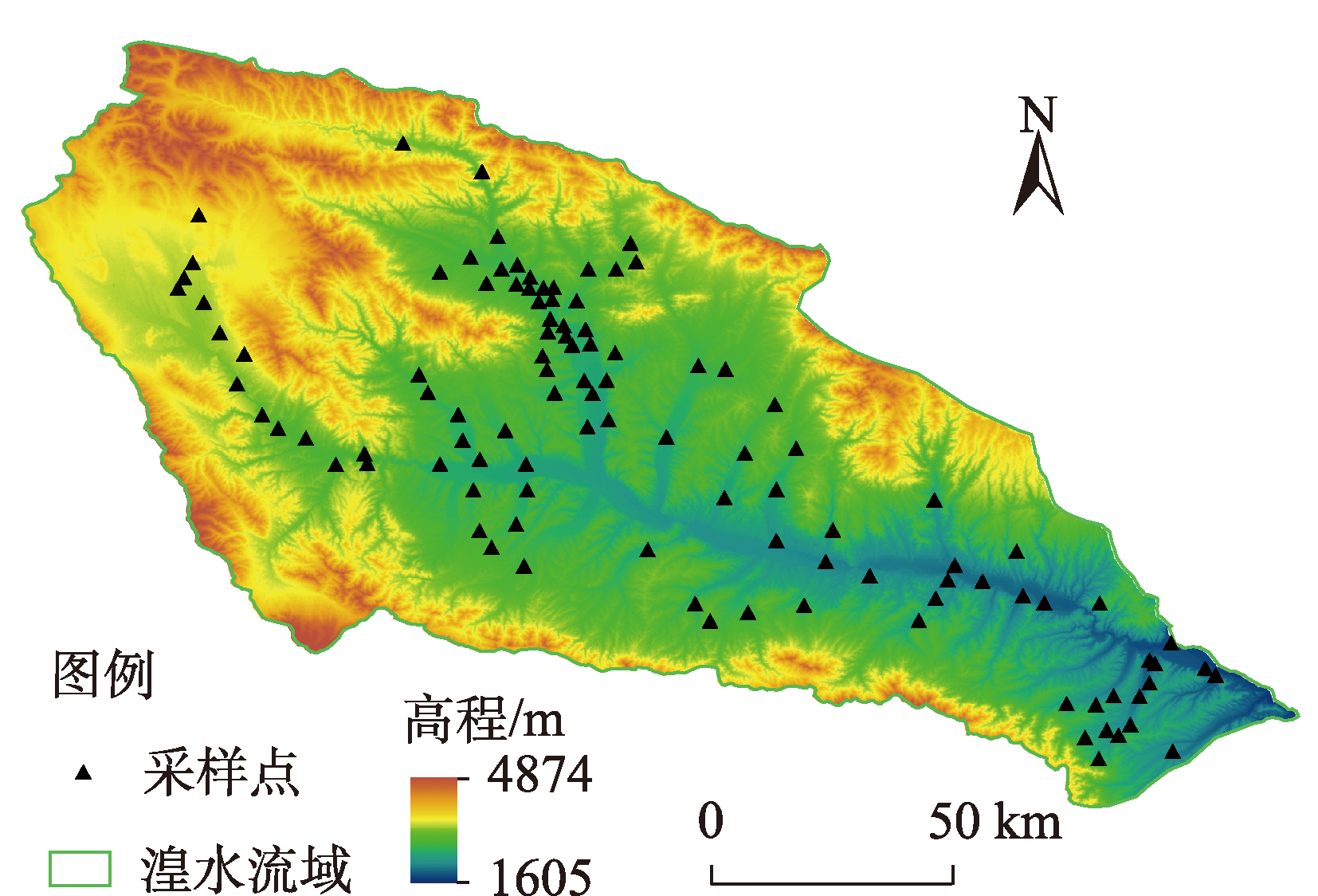

Fig. 2
Flowchart of the nutrient inversion and analysis"

Tab. 1
Routine statistical analysis results of soil nutrients in the Huangshui River Basin"
| 土壤养分 | 样点数/个 | 最小值/g·kg-1 | 最大值/g·kg-1 | 平均值/g·kg-1 | 标准差/g·kg-1 | 变异系数/% |
|---|---|---|---|---|---|---|
| SOM | 107 | 4.310 | 59.789 | 28.377 | 11.168 | 39.356 |
| TN | 107 | 0.372 | 5.874 | 1.232 | 0.856 | 69.481 |
| AP | 107 | 0.001 | 0.162 | 0.055 | 0.032 | 58.182 |
| AK | 107 | 0.048 | 0.488 | 0.204 | 0.087 | 42.647 |
Tab. 2
Correlation analysis between soil nutrients and environmental variables"
| 土壤养分 | 高程 | 坡向 | 坡度 | 平面曲率 | 剖面曲率 | 地形湿度指数 | 地形起伏度 | pH |
|---|---|---|---|---|---|---|---|---|
| SOM | 0.422** | 0.223* | -0.022 | 0.101 | 0.052* | 0.010* | 0.095* | -0.338** |
| TN | 0.595** | 0.238* | -0.174* | -0.015 | 0.089* | 0.052* | 0.276** | -0.485** |
| AP | -0.048 | -0.066* | -0.028 | 0.080* | -0.036 | -0.048 | -0.098* | 0.026 |
| AK | 0.052 | 0.041 | -0.080* | 0.029 | 0.015 | -0.015 | -0.013 | -0.106* |
Tab. 3
Correlation analysis between soil nutrients and band reflectance"
| 波段 | SOM | TN | AP | AK | 波段 | SOM | TN | AP | AK |
|---|---|---|---|---|---|---|---|---|---|
| b1 | -0.390** | -0.343** | 0.118* | -0.039 | lg5 | -0.283** | -0.158 | 0.088 | -0.034 |
| b2 | -0.391** | -0.334** | 0.108* | -0.040 | lg6 | -0.259** | -0.185 | 0.082 | -0.125* |
| b3 | -0.393** | -0.311** | 0.083 | -0.070 | lg7 | -0.251** | -0.247* | 0.069 | -0.169* |
| b4 | -0.379** | -0.280** | 0.085 | -0.084* | 1/b1 | 0.278** | 0.424** | -0.134 | 0.046 |
| b5 | -0.267** | -0.084 | 0.068 | -0.041 | 1/b2 | 0.334** | 0.485** | -0.151* | 0.034 |
| b6 | -0.194* | -0.018 | 0.033 | -0.120 | 1/b3 | 0.376** | 0.491** | -0.142* | 0.044 |
| b7 | -0.174* | -0.073 | 0.008 | -0.180* | 1/b4 | 0.385** | 0.489** | -0.143* | 0.063 |
| lg1 | -0.387** | -0.495** | 0.150* | -0.024 | 1/b5 | 0.300** | 0.247* | -0.112 | 0.029 |
| lg2 | -0.392** | -0.452** | 0.139* | -0.019 | 1/b6 | 0.317** | 0.361** | -0.128 | 0.119* |
| lg3 | -0.394** | -0.407** | 0.113 | -0.051 | 1/b7 | 0.316** | 0.422** | -0.126 | 0.139* |
| lg4 | -0.387** | -0.386** | 0.114 | -0.071 |
Tab. 4
Soil nutrient modeling factors"
| 养分 | 建模因子 |
|---|---|
| SOM | 高程、土壤pH、地形起伏度、lg3、1/b4 |
| TN | 高程、坡向、剖面曲率、地形起伏度、土壤pH、lg1、1/b3 |
| AP | 坡向、平面曲率、地形起伏度、lg1、1/b2 |
| AK | 坡度、地形湿度指数、土壤pH、b7 |

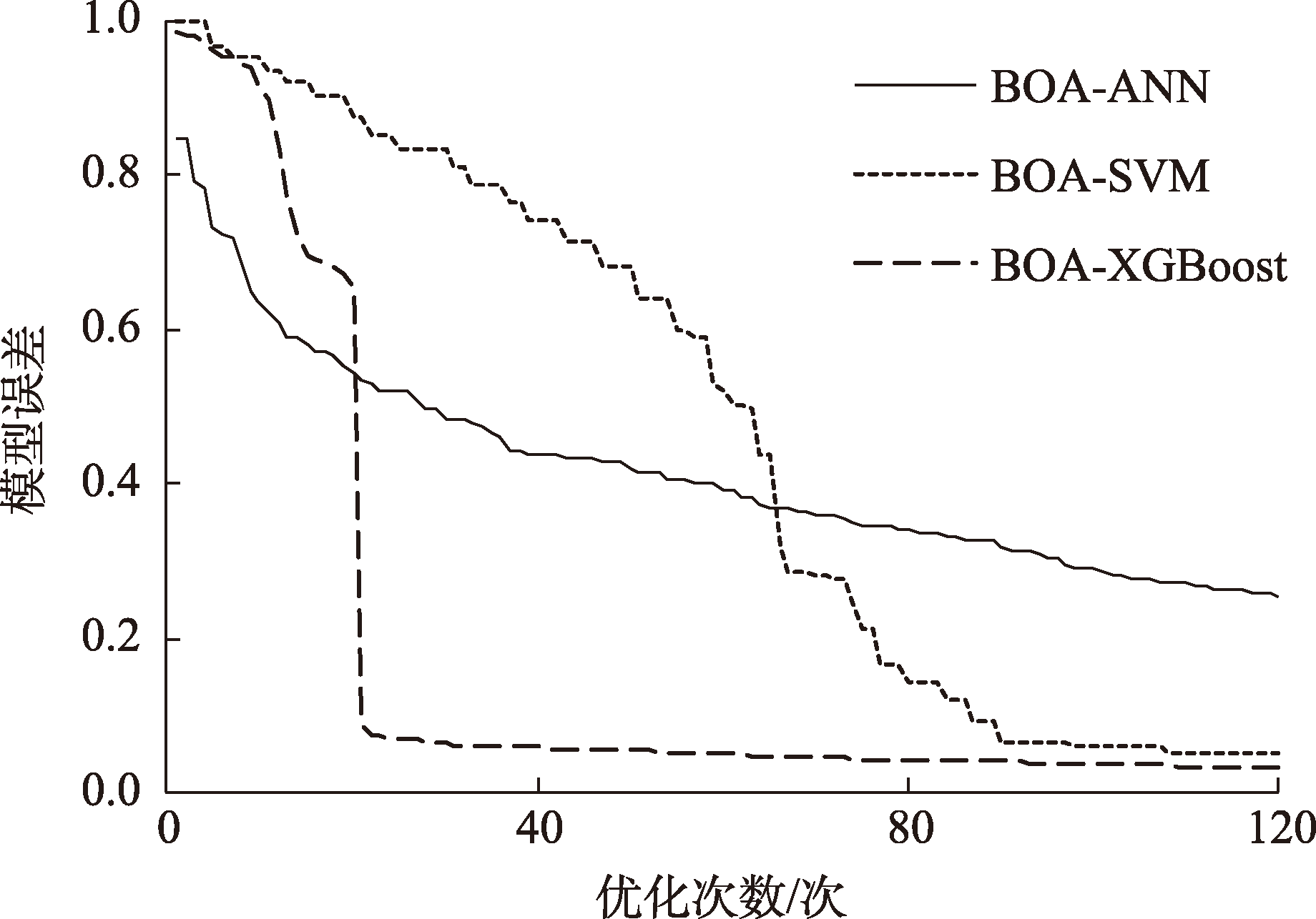
Fig. 3
Model optimization results"
Tab. 5
Optimal hyperparametric combination of the three models"
| 模型 | 参数 | 土壤养分 | |||
|---|---|---|---|---|---|
| SOM | TN | AP | AK | ||
| ANN | 隐藏层节点/个 | 80 | 100 | 120 | 120 |
| 最大迭代次数/次 | 1000 | 1500 | 500 | 500 | |
| 激活函数 | S型函数 | S型函数 | 修正线性单元函数 | 修正线性单元函数 | |
| SVM | 惩罚系数 | 3.12 | 2.50 | 0.35 | 1.10 |
| 核参数 | 0.42 | 0.73 | 0.91 | 0.92 | |
| XGBoost | 树的最大深度 | 4 | 5 | 4 | 4 |
| 最大树数目 | 50 | 30 | 75 | 96 | |
| 学习率 | 0.03 | 0.07 | 0.05 | 0.04 | |
| 最小叶节点样本权重和 | 4 | 4 | 2 | 1 | |
Tab. 6
Precision comparison of different nutrient inversion models"
| 土壤养分 | 模型 | 建模集 | 验证集 | ||||
|---|---|---|---|---|---|---|---|
| R2 | RMSE | R2 | RMSE | RPD | |||
| SOM | ANN | 0.753 | 5.363 | 0.643 | 7.401 | 1.214 | |
| SVM | 0.822 | 5.122 | 0.632 | 5.648 | 1.580 | ||
| XGBoost | 0.910 | 3.791 | 0.801 | 4.321 | 2.152 | ||
| TN | ANN | 0.885 | 0.245 | 0.803 | 0.306 | 2.460 | |
| SVM | 0.871 | 0.415 | 0.735 | 0.252 | 1.886 | ||
| XGBoost | 0.958 | 0.235 | 0.893 | 0.359 | 2.470 | ||
| AP | ANN | 0.491 | 0.040 | 0.382 | 0.030 | 1.002 | |
| SVM | 0.468 | 0.023 | 0.441 | 0.029 | 1.213 | ||
| XGBoost | 0.692 | 0.022 | 0.509 | 0.026 | 1.210 | ||
| AK | ANN | 0.514 | 0.063 | 0.419 | 0.064 | 1.321 | |
| SVM | 0.486 | 0.061 | 0.354 | 0.072 | 1.260 | ||
| XGBoost | 0.692 | 0.043 | 0.442 | 0.055 | 1.274 | ||
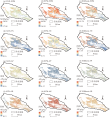
Fig. 4
Spatial distributions of soil nutrients by three models"

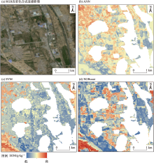
Fig. 5
Local spatial distribution characteristics of SOM"

| [1] | Wang R M, Zou R Y, Liu J M, et al. Spatial distribution of soil nutrients in farmland in a hilly region of the Pearl River Delta in China based on geostatistics and the inverse distance weighting method[J]. Agriculture, 2021, 11(1): 50, doi: 10.3390/agriculture11010050. |
| [2] | Alemu L, Mesfin B. Performance of mid infrared spectroscopy to predict nutrients for agricultural soils in selected areas of Ethiopia[J]. Heliyon, 2022, 8(3): e09050, doi: 10.1016/j.heliyon.2022.e09050. |
| [3] | 刘焕军, 张美薇, 杨昊轩, 等. 多光谱遥感结合随机森林算法反演耕作土壤有机质含量[J]. 农业工程学报, 2020, 36(10): 134-140. |
| [Liu Huanjun, Zhang Meiwei, Yang Haoxuan, et al. Invertion of cultivated soil organic matter content combining multi-spectral remote sensing and random forest algorithm[J]. Transactions of the Chinese Society of Agricultural Engineering, 2020, 36(10): 134-140. ] | |
| [4] |
郑淼, 王翔, 李思佳, 等. 黑土区土壤有机质和全氮含量遥感反演研究[J]. 地理科学, 2022, 42(8): 1336-1347.
doi: 10.13249/j.cnki.sgs.2022.08.002 |
|
[Zheng Miao, Wang Xiang, Li Sijia, et al. Remote sensing inversion of soil organic matter and total nitrogen in black soil region[J]. Scientia Geographica Sinica, 2022, 42(8): 1336-1347. ]
doi: 10.13249/j.cnki.sgs.2022.08.002 |
|
| [5] | Gulhane V A, Rode S V, Pande C B. Wavelet for predicting soil nutrients using remotely sensed satellite images[J]. International Journal of Computer Applications, 2017, 174(4): 35-38. |
| [6] | 李冠稳, 高小红, 杨灵玉, 等. 不同粒径土壤有机质含量可见光-近红外光谱估算研究——以湟水流域为例[J]. 土壤通报, 2017, 48(6): 1360-1370. |
| [Li Guanwen, Gao Xiaohong, Yang Lingyu, et al. Estimating soil organic matter contents from different soil particle size using visible and near-infrared reflectance spectrum: A case study of the Huangshui Basin[J]. Chinese Journal of Soil Science, 2017, 48(6): 1360-1370. ] | |
| [7] | 雷浩川, 刘尊方, 于晓晶, 等. 基于Landsat 5影像的青海省大通县土壤表层全氮空间格局反演[J]. 青海大学学报, 2021, 39(6): 79-86. |
| [Lei Haochuan, Liu Zunfang, Yu Xiaojing, et al. Spatial pattern inversion of soil surface total nitrogen in Datong County of Qinghai Province based on Landsat 5 image[J]. Journal of Qinghai University, 2021, 39(6): 79-86. ] | |
| [8] | 肖云飞. 青海省土壤有机质、全碳、全氮高光谱遥感估算研究[D]. 西宁: 青海师范大学, 2019. |
| [Xiao Yunfei. Estimation of soil organic matter, total carbon and total nitrogen by hyperspectral remote sensing in Qinghai Province[D]. Xining: Qinghai Normal University, 2019. ] | |
| [9] |
李冠稳, 高小红, 肖能文, 等. 基于sCARS-RF算法的高光谱估算土壤有机质含量[J]. 发光学报, 2019, 40(8): 1030-1039.
doi: 10.3788/fgxb |
|
[Li Guanwen, Gao Xiaohong, Xiao Nengwen, et al. Estimation soil organic matter contents with hyperspectra based on sCARS and RF algorithms[J]. Chinese Journal of Luminescence, 2019, 40(8): 1030-1039. ]
doi: 10.3788/fgxb |
|
| [10] | 杨晓宇, 包妮沙, 曹粤, 等. 基于无人机成像光谱技术的农田土壤养分估测及制图[J]. 地理与地理信息科学, 2021, 37(5): 38-45. |
| [Yang Xiaoyu, Bao Nisha, Cao Yue, et al. Estimation and mapping of soil nutrient in farmland based on UAV imaging spectrometry[J]. Geography and Geo-information Science, 2021, 37(5): 38-45. ] | |
| [11] | 郑曼迪, 熊黑钢, 乔娟峰, 等. 基于高光谱的不同人类干扰程度下荒漠土壤有机质含量估算模型[J]. 干旱区地理, 2018, 41(2): 384-392. |
| [Zheng Mandi, Xiong Heigang, Qiao Juanfeng, et al. Hyperspectral based estimation model about organic matter in desert soil at different levels of human disturbance[J]. Arid Land Geography, 2018, 41(2): 384-392. ] | |
| [12] |
Miran N, Rasouli Sadaghiani M H, Feiziasl V, et al. Predicting soil nutrient contents using Landsat OLI satellite images in rain-fed agricultural lands, northwest of Iran[J]. Environmental Monitoring and Assessment, 2021, 193(9): 607, doi: 10.1007/s10661-021-09397-0.
pmid: 34455498 |
| [13] | 张欢, 高小红. 复杂地形区土壤有机质空间变异性分析及制图[J]. 水土保持研究, 2020, 27(5): 93-100. |
| [Zhang Huan, Gao Xiaohong. Analysis of spatial variability and mapping of soil organic matter contents in complex terrain areas[J]. Research of Soil and Water Conservation, 2020, 27(5): 93-100. ] | |
| [14] | Liu Z F, Lei H C, Lei L, et al. Spatial prediction of total nitrogen in soil surface layer based on machine learning[J]. Sustainability, 2022, 14(19): 11998, doi: 10.3390/su141911998. |
| [15] | Dharumarajan S, Lalitha M, Niranjana K, et al. Evaluation of digital soil mapping approach for predicting soil fertility parameters: A case study from Karnataka Plateau, India[J]. Arabian Journal of Geosciences, 2022, 15(5): 386, doi: 10.1007/s12517-022-09629-8. |
| [16] |
杨练兵, 陈春波, 郑宏伟, 等. 基于优化随机森林回归模型的土壤盐渍化反演[J]. 地球信息科学学报, 2021, 23(9): 1662-1674.
doi: 10.12082/dqxxkx.2021.200711 |
|
[Yang Lianbing, Chen Chunbo, Zheng Hongwei, et al. Retrieval of soil salinity content based on random forests regression optimized by Bayesian optimization algorithm and genetic algorithm[J]. Journal of Geo-information Science, 2021, 23(9): 1662-1674. ]
doi: 10.12082/dqxxkx.2021.200711 |
|
| [17] | Wang L Y, Hu P, Zheng H W, et al. Integrative modeling of heterogeneous soil salinity using sparse ground samples and remote sensing images[J]. Geoderma, 2023, 430: 116321, doi: 10.1016/j.geoderma.2022.116321. |
| [18] | Liu F, Qin T L, Yan D H, et al. Classification of instream ecological water demand and crucial values in a semi-arid river basin[J]. Science of the Total Environment, 2020, 712: 136409, doi: 10.1016/j.scitotenv.2019.136409. |
| [19] |
Dong B Q, Qin T L, Wang Y, et al. Spatiotemporal variation of nitrogen and phosphorus and its main influencing factors in Huangshui River Basin[J]. Environmental Monitoring and Assessment, 2021, 193(5): 292, doi: 10.1007/s10661-021-09067-1.
pmid: 33891180 |
| [20] |
Ruhollah T M, Ram N, Sood K, et al. Artificial bee colony feature selection algorithm combined with machine learning algorithms to predict vertical and lateral distribution of soil organic matter in South Dakota, USA[J]. Carbon Management, 2017, 8(3): 277-291.
doi: 10.1080/17583004.2017.1330593 |
| [21] | 杨欣, 袁自然, 叶寅, 等. 基于无人机高光谱遥感的冬小麦全氮含量反演[J]. 光谱学与光谱分析, 2022, 42(10): 3269-3274. |
| [Yang Xin, Yuan Ziran, Ye Yin, et al. Winter wheat total nitrogen content estimation based on UAV hyperspectral remote sensing[J]. Spectroscopy and Spectral Analysis, 2022, 42(10): 3269-3274. ] | |
| [22] | Miao J, Zhen J N, Wang J J, et al. Mapping seasonal leaf nutrients of mangrove with Sentinel-2 images and XGBoost method[J]. Remote Sensing, 2022, 14(15): 3679, doi: 10.3390/rs14153679. |
| [23] | Komolafe A A, Olorunfemi I E, Oloruntoba C, et al. Spatial prediction of soil nutrients from soil, topography and environmental attributes in the northern part of Ekiti State, Nigeria[J]. Remote Sensing Applications: Society and Environment, 2021, 21: 100450, doi: 10.1016/j.rsase.2020.100450. |
| [24] | 代子俊. 近30年湟水流域土壤养分时空变异及影响因素[D]. 西宁: 青海师范大学, 2018. |
| [Dai Zijun. Spatio-temporal variation of soil nuterents in Huangshui River Basin and its affecting factors in the past 30 years[D]. Xining: Qinghai Normal University, 2018. ] | |
| [25] |
方慧婷, 蒙继华, 程志强. 基于遥感与作物模型的土壤速效养分时空变异分析[J]. 中国农业科学, 2019, 52(3): 478-490.
doi: 10.3864/j.issn.0578-1752.2019.03.008 |
|
[Fang Huiting, Meng Jihua, Cheng Zhiqiang. Spatio-temporal variability of soil available nutrients based on remote sensing and crop model[J]. Scientia Agricultura Sinica, 2019, 52(3): 478-490. ]
doi: 10.3864/j.issn.0578-1752.2019.03.008 |
|
| [26] | 刘尊方, 雷浩川, 雷蕾. 湟水流域土壤有机质和速效磷空间布局分析[J]. 科学技术与工程, 2022, 22(34): 15095-15102. |
| [Liu Zunfang, Lei Haochuan, Lei Lei. Analysis on spatial distribution of soil organic matter and available phosphorus in Huangshui River Basin[J]. Science Technology and Engineering, 2022, 22(34): 15095-15102. ] | |
| [27] |
Chen B L, Zheng H W, Luo G P, et al. Adaptive estimation of multi-regional soil salinization using extreme gradient boosting with Bayesian TPE optimization[J]. International Journal of Remote Sensing, 2022, 43(3): 778-811.
doi: 10.1080/01431161.2021.2009589 |
| [28] |
胡亚男, 高小红, 申振宇, 等. 基于野外实测Vis-NIR光谱的土壤肥力估算研究——以湟水流域为例[J]. 土壤通报, 2021, 52(3): 575-584.
doi: 10.1046/j.1365-2389.2001.00419.x |
|
[Hu Ya’nan, Gao Xiaohong, Shen Zhenyu, et al. Estimating fertility index by using field-measured Vis-NIR spectroscopy in the Huangshui River Basin[J]. Chinese Journal of Soil Science, 2021, 52(3): 575-584. ]
doi: 10.1046/j.1365-2389.2001.00419.x |
|
| [29] | Ji W S, Liu Y Q. Research on quantitative evaluation of remote sensing and statistics based on wireless sensors and farmland soil nutrient variability[J]. Computational Intelligence and Neuroscience, 2022, 2022: 3646264, doi: 10.1155/2022/3646264. |
| [30] | 郭静, 龙慧灵, 何津, 等. 基于Google Earth Engine和机器学习的耕地土壤有机质含量预测[J]. 农业工程学报, 2022, 38(18): 130-137. |
| [Guo Jing, Long Huiling, He Jin, et al. Predicting soil organic contents in cultivated land using Google Earth Engine and machine learning[J]. Transactions of the Chinese Society of Agricultural Engineering, 2022, 38(18): 130-137. ] | |
| [31] | 胡贵贵, 杨粉莉, 杨联安, 等. 基于主成分和机器学习的土壤有机质含量空间预测建模[J]. 干旱区地理, 2021, 44(4): 1114-1124. |
| [Hu Guigui, Yang Fenli, Yang Lian’an, et al. Spatial prediction modeling of soil organic matter content based on principal components and machine learning[J]. Arid Land Geography, 2021, 44(4): 1114-1124. ] | |
| [32] | 李莹莹, 赵正勇, 杨旗, 等. 基于GF-1遥感数据预测区域森林土壤有机质含量[J]. 土壤, 2022, 54(1): 191-197. |
| [Li Yingying, Zhao Zhengyong, Yang Qi, et al. Prediction of soil organic matter content based on artificial neural network model and GF-1 remote sensing data[J]. Soils, 2022, 54(1): 191-197. ] | |
| [33] | 孙铭岳. 基于多源遥感的黄河三角洲耕地土壤盐分和有机质含量反演[D]. 泰安: 山东农业大学, 2022. |
| [Sun Mingyue. Inversion of soil salinity and organic matter on arable land in the Yellow River Delta based on multi-source remote sensing[D]. Tai’an: Shandong Agricultural University, 2022. ] | |
| [34] | 杜军, 古军伟, 邱士可, 等. 基于支持向量回归的土壤全氮含量高光谱估测研究[J]. 河南科学, 2020, 38(10): 1585-1590. |
| [Du Jun, Gu Junwei, Qiu Shike, et al. Prediction of total nitrogen by using hyperspectral data based on support vector regression[J]. Henan Science, 2020, 38(10): 1585-1590. ] |
| [1] | ZHU Lei, LI Yannan, XU Jiahui, HU Jing, ZHU Fang, LIANG Mangmang. Spatial distribution pattern and causes of ice and snow tourism in China [J]. Arid Land Geography, 2024, 47(8): 1399-1410. |
| [2] | CHEN Cong, TANG Ying, SHI Chengyong, DU Yifan, ZHAO Lina, JIANG Xuyan. Spatial distribution and regional cooperative conservation of heritage resources in the Yellow River Basin [J]. Arid Land Geography, 2024, 47(7): 1220-1232. |
| [3] | ZHANG Zhiming, SUN Xiaomei, BAO Duanhong, YAO Baohui, WANG Zhicheng, SU Junhu. Biomass and soil nutrient characteristics of five dominant plant species in the desert grassland of the northern foothills of the Qilian Mountains [J]. Arid Land Geography, 2024, 47(4): 662-671. |
| [4] | JIANG Yuekun, SHI Pengjuan. Spatiotemporal evolution and its affecting factors of urban-rural income gap at the city-level scale in China [J]. Arid Land Geography, 2024, 47(1): 147-157. |
| [5] | HUANG Xin, JIAO Li, MA Xiaofei, WANG Yonghui, Aerman ABULA. Change characteristics of extreme precipitation events in Central Asia in recent 60 years based on RClimDex model [J]. Arid Land Geography, 2023, 46(7): 1039-1051. |
| [6] | KANG Ligang, CAO Shengkui, CAO Guangchao, YAN Li, CHEN Lianxuan, LI Wenbin, ZHAO Haoran. Spatiotemporal variation of land surface temperature in Qinghai Lake Basin [J]. Arid Land Geography, 2023, 46(7): 1084-1097. |
| [7] | PAN Xue, GUAN Yuqi, PAN Zhandong, LIU Jie, CAI Liqun, DONG Bo, DU Jian. Spatiotemporal variation and evaluation of cultivated land quality grade in arid areas: A case of Xining City [J]. Arid Land Geography, 2023, 46(5): 793-803. |
| [8] | DING Hua,LIAO Wenqiang,DUAN Fenghao,YANG Wangtun. Characteristics, spatial distribution and formation mechanism of Danxia landform in Shaanxi Province [J]. Arid Land Geography, 2023, 46(4): 527-538. |
| [9] | LU Xiongying, LIU Xiande, MA Rui, ZHAO Weijun, JING Wenmao, HE Xiaoling, ZHAO Changxing. Response of Picea crassifolia forest regeneration characteristics to topographic factors in Pailugou watershed of Qilian Mountains [J]. Arid Land Geography, 2023, 46(4): 604-613. |
| [10] | WEI Juanjuan, WAN Yu, ZHANG Junlan, ZHAO Fenghuan, LI Anbei. Circulation classification and cause analysis of the warm-area blizzards in Tacheng area in recent 20 years [J]. Arid Land Geography, 2022, 45(6): 1718-1728. |
| [11] | GUO Xin, WEI Tianxing, CHEN Yuxuan, SHA Guoliang, REN Kang, YU Huan. Characteristics of soil ecological stoichiometry in typical fallow-restored vegetation in the loess hilly areas [J]. Arid Land Geography, 2022, 45(6): 1899-1907. |
| [12] | Maihemutijiang WEIJIDAN,Yusufujiang RUSULI,QIU Zhongli. Temporal and spatial changes of the snow cover cessation day from 2000 to 2019 in Xinjiang, China [J]. Arid Land Geography, 2022, 45(4): 1061-1070. |
| [13] | PAN Qun,SHI Haiyang,ZHANG Wenqiang,LUO Geping,CHEN Chunbo. Spatiotemporal distribution of rat population density in grassland on the north slope of Tianshan Mountains based on Cubist model [J]. Arid Land Geography, 2022, 45(4): 1200-1211. |
| [14] | ZHANG Zhongfu. Spatial division and sustainable development and utilization strategy of geological relics in Gansu section of the Yellow River Basin [J]. Arid Land Geography, 2022, 45(4): 1235-1243. |
| [15] | LI Jining,LIU Wanying. Spatial distribution and influencing factors of village sites along the Silk Road in the Han Dynasty in Ningxia [J]. Arid Land Geography, 2022, 45(4): 1291-1301. |
| Viewed | ||||||||||||||||||||||||||||||||||||||||||||||||||
|
Full text 67
|
|
|||||||||||||||||||||||||||||||||||||||||||||||||
|
Abstract 237
|
|
|||||||||||||||||||||||||||||||||||||||||||||||||
Cited |
|
|||||||||||||||||||||||||||||||||||||||||||||||||
| Shared | ||||||||||||||||||||||||||||||||||||||||||||||||||
|
||