干旱区地理 ›› 2025, Vol. 48 ›› Issue (8): 1406-1420.doi: 10.12118/j.issn.1000-6060.2024.590 cstr: 32274.14.ALG2024590
王嘉伟1( ), 董国涛2(), 蒋晓辉1, 聂桐1, 李跃红1
收稿日期:2024-11-18
修回日期:2025-01-26
出版日期:2025-08-25
发布日期:2025-08-21
通讯作者:
董国涛(1982-),男,博士,正高级工程师,主要从事干旱区水文过程模拟、水资源调度与配置、生态环境遥感研究. E-mail: dongguotao001@163.com作者简介:王嘉伟(2000-),男,硕士,主要从事生态系统服务研究. E-mail: 202232909@stumail.nwu.edu.cn
基金资助:
WANG Jiawei1(), DONG Guotao2(), JIANG Xiaohui1, NIE Tong1, LI Yuehong1
Received:2024-11-18
Revised:2025-01-26
Published:2025-08-25
Online:2025-08-21
摘要: 黑河流域生态调水等政策实施有效缓解了该流域生态环境恶化趋势,生态环境质量显著改善。在该流域目前已有的研究成果中,针对生态系统服务时空演变特征的研究时段较短、区域局限,且大多未对其受环境治理政策及其他驱动因素影响进行定性定量分析。以黑河流域为研究区域,旨在揭示1990—2022年产水深度、生境质量、碳储存量和土壤保持量的时空演变特征,通过耦合InVEST-PLUS模型评估生态输水对下游生态系统服务的影响,并利用地理探测器解析驱动因素。结果表明:(1)2000年后,流域碳储存量和生境质量整体呈增加趋势,产水深度与土壤保持量则呈先增后减趋势。空间上呈现“南高北低”阶梯状分布,高值集中于祁连山区,低值分布于中下游荒漠带。(2)下游碳储量、生境质量与正义峡年均径流量显著正相关(P<0.05)。相较于自然发展情景,生态输水使两者在实际情景下呈现逐年增加趋势。(3)地理探测器各驱动因子中,数字高程、气温、降水量和潜在蒸散发占主导地位。地理探测器结果显示因子交互解释力对生态系统服务的影响高于单因子解释力。研究结果可为黑河流域生态治理与水资源配置提供科学依据。
王嘉伟, 董国涛, 蒋晓辉, 聂桐, 李跃红. 生态输水背景下黑河流域生态系统服务的时空演变特征及驱动力研究[J]. 干旱区地理, 2025, 48(8): 1406-1420.
WANG Jiawei, DONG Guotao, JIANG Xiaohui, NIE Tong, LI Yuehong. Spatiotemporal evolution characteristics and driving forces of ecosystem services in the Heihe River Basin under the context of ecological water conveyance[J]. Arid Land Geography, 2025, 48(8): 1406-1420.
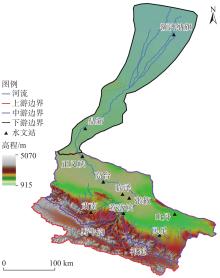
图1
研究区示意图"

表1
数据分辨率及来源"
| 数据类型 | 分辨率 | 数据来源 |
|---|---|---|
| 月均降水量 | 1 km×1 km | 国家青藏高原中心( |
| 月均潜在蒸散发 | 1 km×1 km | 国家青藏高原中心( |
| 月均气温 | 1 km×1 km | 国家青藏高原中心( |
| 土地利用类型 | 30 m×30 m | 地球大数据科学工程数据共享平台( |
| 土壤数据 | 1 km×1 km | 联合国粮农组织( |
| 数字高程 | 90 m×90 m | 地理空间数据云( |
| 根系深度 | 1 km×1 km | Scientific Data-Nature( |
| 植被归一化指数 | 30 m×30 m | 科学数据银行( |
| 人口密度 | 1 km×1 km | 北京树谷信息科技有限公司( |
| 国内生产总值 | 1 km×1 km | 北京树谷信息科技有限公司( |
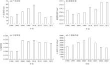
图2
1990—2022年生态系统服务年变化"

表2
1990—2022年黑河流域生态系统服务"
| 年份 | 产水深度/mm | 土壤保持量/t·hm-2 | 碳储存量/t·hm-2 | 生境质量 | |||||||||||
|---|---|---|---|---|---|---|---|---|---|---|---|---|---|---|---|
| 上游 | 中游 | 下游 | 上游 | 中游 | 下游 | 上游 | 中游 | 下游 | 上游 | 中游 | 下游 | ||||
| 1990 | 65.57 | 20.02 | 15.53×10⁻⁵ | 7429.93 | 2687.58 | 1.42 | 242.29 | 161.29 | 33.52 | 0.6851 | 0.4088 | 0.0445 | |||
| 1995 | 84.67 | 26.23 | 32.24×10⁻⁵ | 8329.02 | 3025.15 | 1.56 | 242.09 | 160.31 | 33.26 | 0.6892 | 0.4105 | 0.0392 | |||
| 2000 | 112.96 | 33.22 | 6.70×10⁻⁵ | 9934.19 | 3516.55 | 1.27 | 242.46 | 160.25 | 33.55 | 0.6983 | 0.4307 | 0.0468 | |||
| 2005 | 149.34 | 41.58 | 6.40×10⁻⁵ | 11519.35 | 3875.54 | 1.25 | 242.39 | 160.23 | 34.15 | 0.6970 | 0.4271 | 0.0484 | |||
| 2010 | 172.02 | 53.29 | 21.31×10⁻⁵ | 12759.41 | 4484.87 | 1.44 | 242.61 | 161.00 | 34.94 | 0.6959 | 0.4282 | 0.0515 | |||
| 2015 | 109.78 | 31.43 | 5.10×10⁻⁵ | 9655.20 | 3361.11 | 1.26 | 242.01 | 160.78 | 34.82 | 0.6881 | 0.4262 | 0.0512 | |||
| 2020 | 61.88 | 16.85 | 0.88×10⁻⁵ | 7294.06 | 2421.13 | 1.06 | 242.04 | 162.30 | 35.33 | 0.6853 | 0.4254 | 0.0531 | |||
| 2022 | 71.82 | 22.41 | 0.73×10⁻⁵ | 6833.22 | 2451.68 | 1.01 | 242.78 | 162.16 | 35.16 | 0.6854 | 0.4235 | 0.0532 | |||
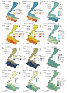
图3
1990—2022年生态系统服务空间分布及其变化"

表3
1990—2022年生态系统服务全局Moran’s I指数"
| 年份 | 产水深度 | 土壤保持量 | 碳储存量 | 生境质量 | |||||||
|---|---|---|---|---|---|---|---|---|---|---|---|
| Iglobal | P值 | Iglobal | P值 | Iglobal | P值 | Iglobal | P值 | ||||
| 1990 | 0.9387 | 0.0000 | 0.9020 | 0.0000 | 0.9648 | 0.0000 | 0.9570 | 0.0000 | |||
| 2022 | 0.9530 | 0.0000 | 0.9058 | 0.0000 | 0.9645 | 0.0000 | 0.9589 | 0.0000 | |||
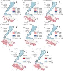
图4
1990—2022年生态系统服务局部(LISA)聚类图"

表4
1990—2022年生态系统服务空间聚类占比"
| 聚类类型 | 产水深度 | 土壤保持量 | 碳储存量 | 生境质量 | |||||||
|---|---|---|---|---|---|---|---|---|---|---|---|
| 1990年 | 2022年 | 1990年 | 2022年 | 1990年 | 2022年 | 1990年 | 2022年 | ||||
| 高-高聚类 | 12.69 | 12.94 | 16.27 | 16.09 | 32.66 | 32.63 | 25.34 | 23.62 | |||
| 高-低聚类 | 0.00 | 0.00 | 0.00 | 0.00 | 0.00 | 0.00 | 0.00 | 0.01 | |||
| 不显著区域 | 44.74 | 44.41 | 44.86 | 44.13 | 33.72 | 34.53 | 41.04 | 44.48 | |||
| 低-低聚类 | 42.57 | 42.65 | 38.84 | 39.76 | 33.59 | 32.82 | 33.58 | 31.88 | |||
| 低-高聚类 | 0.00 | 0.00 | 0.03 | 0.02 | 0.02 | 0.02 | 0.04 | 0.01 | |||
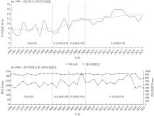
图5
1990—2022年不同水量调度时期下正义峡年径流量、降水量和潜在蒸散发变化"
表5
1990—2022年正义峡年均径流量与下游生态系统服务"
| 年份 | 年均径流量/108 m3 | 产水深度/10-5 mm | 土壤保持量/t·hm-2 | 碳储存量/t·hm-2 | 生境质量 |
|---|---|---|---|---|---|
| 1990 | 8.62 | 15.53 | 1.42 | 33.52 | 0.0445 |
| 1995 | 7.26 | 32.24 | 1.56 | 33.26 | 0.0392 |
| 2000 | 7.96 | 6.70 | 1.27 | 33.55 | 0.0468 |
| 2005 | 9.22 | 6.40 | 1.25 | 34.15 | 0.0484 |
| 2010 | 11.26 | 21.31 | 1.44 | 34.94 | 0.0515 |
| 2015 | 12.70 | 5.10 | 1.26 | 34.82 | 0.0512 |
| 2020 | 14.35 | 0.88 | 1.06 | 35.33 | 0.0532 |
| 2022 | 12.36 | 0.73 | 1.01 | 35.16 | 0.0532 |
表6
正义峡年均径流量与下游生态系统服务间的相关系数"
| 相关系数 | 产水深度 | 土壤保持量 | 碳储存量 | 生境质量 |
|---|---|---|---|---|
| Pearson | -0.6058 | -0.6571 | 0.8891(P<0.01) | 0.8299(P<0.05) |
| Spearman | -0.7143(P<0.05) | -0.6190 | 0.8571(P<0.01) | 0.8383(P<0.01) |
表7
1990—2022年下游碳储存量及生境质量模拟结果与实际对比"
| 年份 | 碳储存量/t·hm-2 | 生境质量 | |||
|---|---|---|---|---|---|
| 实际 | 模拟 | 实际 | 模拟 | ||
| 1990 | 33.52 | - | 0.0445 | - | |
| 1995 | 33.26 | - | 0.0392 | - | |
| 2000 | 33.55 | 32.21 | 0.0468 | 0.0370 | |
| 2005 | 34.15 | 31.72 | 0.0484 | 0.0348 | |
| 2010 | 34.94 | 31.42 | 0.0515 | 0.0337 | |
| 2015 | 34.82 | 31.06 | 0.0513 | 0.0323 | |
| 2020 | 35.33 | 30.83 | 0.0532 | 0.0311 | |
| 2022 | 35.16 | 30.39 | 0.0532 | 0.0301 | |
表8
地理探测器中驱动因子q值及排名"
| 驱动因子 | 解释力(q值)(排名) | |||
|---|---|---|---|---|
| 产水深度 | 土壤保持量 | 碳储存量 | 生境质量 | |
| 降水量(PRE) | 0.9141(2) | 0.6160(1) | 0.7981(4) | 0.7509(4) |
| 潜在蒸散发(PET) | 0.9140(3) | 0.5960(2) | 0.8181(3) | 0.7667(2) |
| 气温(TEP) | 0.9024(4) | 0.5880(3) | 0.8247(2) | 0.7658(3) |
| 人口分布(POP) | 0.0368(7) | 0.0864(7) | 0.1440(7) | 0.1590(7) |
| 地区生产总值(GDP) | 0.3240(6) | 0.3424(5) | 0.4357(6) | 0.4225(6) |
| 归一化植被指数(NDVI) | 0.3283(5) | 0.2661(6) | 0.6824(5) | 0.6561(5) |
| 数字高程(DEM) | 0.9146(1) | 0.5875(4) | 0.8379(1) | 0.7756(1) |
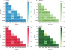
图6
驱动因子交互探测结果 注:DEM为数字高程;GDP为地区生产总值;NDVI为归一化植被指数;PET为潜在蒸散发;POP为人口分布;PRE为降水量;TEP为气温。"

| [1] | 康婷婷, 李增, 高彦春. 西北干旱区山地-绿洲-荒漠系统生态恢复综合效益评估[J]. 生态学报, 2019, 39(20): 7418-7431. |
| [Kang Tingting, Li Zeng, Gao Yanchun. Effectiveness of ecological restoration in the mountain-oasis-desert system of northwestern arid area of China[J]. Acta Ecologica Sinica, 2019, 39(20): 7418-7431. ] | |
| [2] |
赵军, 马小平, 魏伟. 近50年黑河流域潜在植被的演替及生态环境变化研究[J]. 草业学报, 2014, 23(5): 61-68.
doi: 10.11686/cyxb20140507 |
|
[Zhao Jun, Ma Xiaoping, Wei Wei. Vegetation succession and ecological changes in the Heihe River watershed over the past 50 years[J]. Acta Prataculturae Sinica, 2014, 23(5): 61-68. ]
doi: 10.11686/cyxb20140507 |
|
| [3] | Ma Z, Kang S, Zhang L, et al. Analysis of impacts of climate variability and human activity on streamflow for a river basin in arid region of northwest China[J]. Journal of Hydrology, 2008, 352(3/4): 239-249. |
| [4] |
蒋晓辉, 夏军, 黄强, 等. 黑河“97”分水方案适应性分析[J]. 地理学报, 2019, 74(1): 103-116.
doi: 10.11821/dlxb201901008 |
|
[Jiang Xiaohui, Xia Jun, Huang Qiang, et al. Adaptability analysis of the Heihe River “97” water diversion scheme[J]. Acta Geographica Sinica, 2019, 74(1): 103-116. ]
doi: 10.11821/dlxb201901008 |
|
| [5] | Zhang L, Dawes W R, Walker G R. Response of mean annual evapotranspiration to vegetation changes at catchment scale[J]. Water Resources Research, 2001, 37(3): 701-708. |
| [6] | Daily G C. Nature’s services: Societal dependence on natural ecosystems[M]. Washington: Island Press, 2013: 454-464. |
| [7] | Costanza R, D’Arge R, De Groot R, et al. The value of the world’s ecosystem services and natural capital[J]. Nature, 1997, 387(6630): 253-260. |
| [8] | 曹祺文, 卫晓梅, 吴健生. 生态系统服务权衡与协同研究进展[J]. 生态学杂志, 2016, 35(11): 3102-3111. |
| [Cao Qiwen, Wei Xiaomei, Wu Jiansheng. A review on the tradeoffs and synergies among ecosystem services[J]. Chinese Journal of Ecology, 2016, 35(11): 3102-3111. ] | |
| [9] |
张静静, 朱文博, 朱连奇, 等. 伏牛山地区森林生态系统服务权衡/协同效应多尺度分析[J]. 地理学报, 2020, 75(5): 975-988.
doi: 10.11821/dlxb202005007 |
|
[Zhang Jingjing, Zhu Wenbo, Zhu Lianqi, et al. Multi-scale analysis of trade-off/synergy effects of forest ecosystem services in the Funiu Mountain region[J]. Acta Geographica Sinica, 2020, 75(5): 975-988. ]
doi: 10.11821/dlxb202005007 |
|
| [10] |
张福平, 李肖娟, 冯起, 等. 基于InVEST模型的黑河流域上游水源涵养量[J]. 中国沙漠, 2018, 38(6): 1321-1329.
doi: 10.7522/j.issn.1000-694X.2017.00085 |
|
[Zhang Fuping, Li Xiaojuan, Feng Qi, et al. Spatial and temporal variation of water conservation in the upper reaches of Heihe River Basin based on InVEST model[J]. Journal of Desert Research, 2018, 38(6): 1321-1329. ]
doi: 10.7522/j.issn.1000-694X.2017.00085 |
|
| [11] |
李芳, 张金龙, 杨环. 基于InVEST模型的黑河流域上游1990—2018年产水量模拟[J]. 高原气象, 2022, 41(3): 698-707.
doi: 10.7522/j.issn.1000-0534.2022.00057 |
|
[Li Fang, Zhang Jinlong, Yang Huan. Simulation of annual water yield in the upper Heihe River Basin from 1990 to 2018 based on InVEST[J]. Plateau Meteorology, 2022, 41(3): 698-707. ]
doi: 10.7522/j.issn.1000-0534.2022.00057 |
|
| [12] | 王蓓, 赵军, 胡秀芳. 基于InVEST模型的黑河流域生态系统服务空间格局分析[J]. 生态学杂志, 2016, 35(10): 2783-2792. |
| [Wang Bei, Zhao Jun, Hu Xiufang. Spatial pattern analysis of ecosystem services based on InVEST in Heihe River Basin[J]. Chinese Journal of Ecology, 2016, 35(10): 2783-2792. ] | |
| [13] | 朱春霞, 钟绍卓, 龙宇, 等. 黄河流域生态系统服务的时空演变及其驱动力[J]. 生态学杂志, 2023, 42(10): 2502-2513. |
|
[Zhu Chunxia, Zhong Shaozhuo, Long Yu, et al. Spatiotemporal variation of ecosystem services and their drivers in the Yellow River Basin, China[J]. Chinese Journal of Ecology, 2023, 42(10): 2502-2513. ]
doi: 10.13292/j.1000-4890.202310.005 |
|
| [14] | 韩武宏. 基于InVEST模型的祁连山国家公园生态系统服务功能评估及其驱动力研究[D]. 兰州: 西北师范大学, 2022. |
| [Han Wuhong. Evaluation of ecosystem services in Qilian Mountain National Park based on InVEST model and its driving forces[D]. Lanzhou: Northwest Normal University, 2022. ] | |
| [15] |
包玉斌, 李婷, 柳辉, 等. 基于InVEST模型的陕北黄土高原水源涵养功能时空变化[J]. 地理研究, 2016, 35(4): 664-676.
doi: 10.11821/dlyj201604006 |
| [Bao Yubin, Li Ting, Liu Hui, et al. Spatial and temporal changes of water conservation of Loess Plateau in northern Shaanxi Province by InVEST model[J]. Geographical Research, 2016, 35(4): 664-676. ] | |
| [16] | 李成, 赵洁, 庄智程, 等. 长三角城市群生态系统服务权衡强度时空演变及影响因素[J]. 生态学报, 2022, 42(14): 5708-5720. |
| [Li Cheng, Zhao Jie, Zhuang Zhicheng, et al. Spatiotemporal dynamics and influencing factors of ecosystem service trade-offs in the Yangtze River Delta urban agglomeration[J]. Acta Ecologica Sinica, 2022, 42(14): 5708-5720. ] | |
| [17] | 何佳瑛, 蒋晓辉, 雷宇昕. 黄土高原生态工程对关键生态系统服务时空变化的影响——以延河流域为例[J]. 生态学报, 2023, 43(12): 4823-4834. |
| [He Jiaying, Jiang Xiaohui, Lei Yuxin. Effects of ecological engineering on spatio-temporal changes of key ecosystem services on the Loess Plateau: A case study in the Yanhe River Basin, China[J]. Acta Ecologica Sinica, 2023, 43(12): 4823-4834. ] | |
| [18] | Fu B J, Zhao W W, Chen L D, et al. Assessment of soil erosion at large watershed scale using RUSLE and GIS: A case study in the Loess Plateau of China[J]. Land Degradation & Development, 2005, 16(1): 73-85. |
| [19] | 陈童尧, 贾燕锋, 王佳楠, 等. 基于InVEST模型的祁连山国家级自然保护区土壤保持现状与功能[J]. 干旱区研究, 2020, 37(1): 150-159. |
| [Chen Tongyao, Jia Yanfeng, Wang Jianan, et al. Current situation and function of soil conservation in National Nature Reserves in the Qilian Mountains based on InVEST model[J]. Arid Zone Research, 2020, 37(1): 150-159. ] | |
| [20] | 胡秀芳, 赵军, 王蓓, 等. 黑河流域生态系统服务空间协同与权衡变化[J]. 生态学杂志, 2022, 41(3): 580-588. |
|
[Hu Xiufang, Zhao Jun, Wang Bei, et al. Changes of spatial synergies or trade-offs of ecosystem services in Heihe River Basin[J]. Chinese Journal of Ecology, 2022, 41(3): 580-588. ]
doi: 10.13292/j.1000-4890.202201.001 |
|
| [21] | 王耕, 冯妍. 辽宁太子河流域生态系统服务权衡/协同关系时空变化与情景预测[J]. 生态学报, 2024, 44(1): 96-106. |
| [Wang Geng, Feng Yan. Spatio-temporal variation and scenario prediction of ecosystem service tradeoffs/synergies in the Taizi River Basin Liaoning Province[J]. Acta Ecologica Sinica, 2024, 44(1): 96-106. ] | |
| [22] | 刘颂, 张浩鹏, 裴新生, 等. 长时间序列生态系统服务权衡与协同驱动因素——以芜湖市生态系统服务功能极重要区为例[J]. 生态学报, 2024, 44(5): 1780-1790. |
| [Liu Song, Zhang Haopeng, Pei Xinsheng, et al. Drivers of ecosystem service trade-off and synergy in long-term sequence: A case study of the extremely important ecosystem service function area in Wuhu City[J]. Acta Ecologica Sinica, 2024, 44(5): 1780-1790. ] | |
| [23] |
许宝荣, 刘一川, 董莹, 等. 基于InVEST模型的兰州地区生境质量评价[J]. 中国沙漠, 2021, 41(5): 120-129.
doi: 10.7522/j.issn.1000-694X.2021.00049 |
|
[Xu Baorong, Liu Yichuan, Dong Ying, et al. Evaluation of habitat quality in Lanzhou region based on InVEST model[J]. Journal of Desert Research, 2021, 41(5): 120-129. ]
doi: 10.7522/j.issn.1000-694X.2021.00049 |
|
| [24] | 张华, 韩武宏, 宋金岳, 等. 祁连山国家公园生境质量时空演变[J]. 生态学杂志, 2021, 40(5): 1419-1430. |
| [Zhang Hua, Han Wuhong, Song Jinyue, et al. Spatial-temporal variations of habitat quality in Qilian Mountain National Park[J]. Chinese Journal of Ecology, 2021, 40(5): 1419-1430. ] | |
| [25] | Wang J F, Zhang T L, Fu B J. A measure of spatial stratified heterogeneity[J]. Ecological Indicators, 2016, 67: 250-256. |
| [26] | 孟斌, 王劲峰, 张文忠, 等. 基于空间分析方法的中国区域差异研究[J]. 地理科学, 2005, 25(4): 393-400. |
|
[Meng Bin, Wang Jinfeng, Zhang Wenzhong, et al. Evaluation of regional disparity in China based on spatial analysis[J]. Scientia Geographica Sinica, 2005, 25(4): 393-400. ]
doi: 10.13249/j.cnki.sgs.2005.04.393 |
|
| [27] | Liang X, Guan Q F, Clarke K C, et al. Understanding the drivers of sustainable land expansion using a patch-generating land use simulation (PLUS) model: A case study in Wuhan, China[J]. Computers Environment and Urban Systems, 2021, 85: 101569, doi: 10.1016/j.compenvurbsys.2020.101569. |
| [28] |
蒋小芳, 段翰晨, 廖杰, 等. 基于PLUS-SD耦合模型的黑河流域中游甘临高地区土地利用研究[J]. 干旱区研究, 2022, 39(4): 1246-1258.
doi: 10.13866/j.azr.2022.04.25 |
|
[Jiang Xiaofang, Duan Hanchen, Liao Jie, et al. Land use in the Gan-Lin-Gao region of middle reaches of Heihe River Basin based on a PLUS-SD coupling model[J]. Arid Zone Research, 2022, 39(4): 1246-1258. ]
doi: 10.13866/j.azr.2022.04.25 |
|
| [29] | 秦正, 高宇潇, 萨木哈·单山白. 基于PLUS-InVEST的济南多情景土地利用变化模拟与碳储量评估[J]. 人民黄河, 2024, 46(5): 117-122. |
| [Qin Zheng, Gao Yuxiao, Sarsenbay Samha. Multi scenario land use change simulation and carbon storage assessment in Jinan City based on PLUS-InVEST model[J]. Yellow River, 2024, 46(5): 117-122. ] | |
| [30] | 任胤铭, 刘小平, 许晓聪, 等. 基于FLUS-InVEST模型的京津冀多情景土地利用变化模拟及其对生态系统服务功能的影响[J]. 生态学报, 2023, 43(11): 4473-4487. |
| [Ren Yinming, Liu Xiaoping, Xu Xiaocong, et al. Multi-scenario simulation of and use change and its impact on ecosystem services in Beijing-Tianjin-Hebei region based on the FLUS-InVEST model[J]. Acta Ecologica Sinica, 2023, 43(11): 4473-4487. ] | |
| [31] |
胡丰, 张艳, 郭宇, 等. 基于PLUS和InVEST模型的渭河流域土地利用与生境质量时空变化及预测[J]. 干旱区地理, 2022, 45(4): 1125-1136.
doi: 10.12118/j.issn.1000-6060.2021.510 |
|
[Hu Feng, Zhang Yan, Guo Yu, et al. Spatial and temporal changes in land use and habitat quality in the Weihe River Basin based on the PLUS and InVEST models and predictions[J]. Arid Land Geography, 2022, 45(4): 1125-1136. ]
doi: 10.12118/j.issn.1000-6060.2021.510 |
|
| [32] | 方匡南, 吴见彬, 朱建平, 等. 随机森林方法研究综述[J]. 统计与信息论坛, 2011, 26(3): 7. |
| [Fang Kuangnan, Wu Jianbin, Zhu Jianping, et al. A review of technologies on random forests[J]. Journal of Statistics and Information, 2011, 26(3): 7. ] | |
| [33] | Breiman L. Random forests[J]. Machine Learning, 2001, 45: 5-32. |
| [34] |
王劲峰, 徐成东. 地理探测器: 原理与展望[J]. 地理学报, 2017, 72(1): 116-134.
doi: 10.11821/dlxb201701010 |
|
[Wang Jinfeng, Xu Chengdong. Geodetector: Principle and prospective[J]. Acta Geographica Sinica, 2017, 72(1): 116-134. ]
doi: 10.11821/dlxb201701010 |
|
| [35] | 李传哲, 于福亮, 刘佳, 等. 近20年来黑河干流中游地区土地利用/覆被变化及驱动力定量研究[J]. 自然资源学报, 2011, 26(3): 353-363. |
|
[Li Chuanzhe, Yu Fuliang, Liu Jia, et al. Research on land use/cover change and its driving force in midstream of the Heihe Mainstream Basin during the past 20 years[J]. Journal of Natural Resources, 2011, 26(3): 353-363. ]
doi: 10.11849/zrzyxb.2011.03.001 |
|
| [36] | 薛晓玉, 王晓云, 段含明, 等. 基于土地利用变化的祁连山地区生境质量时空演变分析[J]. 水土保持通报, 2020, 40(2): 278-284, 325. |
| [Xue Xiaoyu, Wang Xiaoyun, Duan Hanming, et al. Analysis on spatio-temporal evolution of habitat quality in Qilian Mountains based on land use change[J]. Bulletin of Soil and Water Conservation, 2020, 40(2): 278-284, 325. ] | |
| [37] | 王雅, 蒙吉军. 黑河中游土地利用变化对生态系统服务的影响[J]. 干旱区研究, 2017, 34(1): 200-207. |
| [Wang Ya, Meng Jijun. Effects of land use change on ecosystem services in the middle reaches of the Heihe River Basin[J]. Arid Zone Research, 2017, 34(1): 200-207. ] | |
| [38] | Thevs N, Peng H, Rozi A, et al. Water allocation and water consumption of irrigated agriculture and natural vegetation in the Aksu-Tarim River Basin, Xinjiang, China[J]. Journal of Arid Environments, 2015, 112: 87-97. |
| [39] | Yan F, Shangguan W, Zhang J, et al. Depth-to-bedrock map of China at a spatial resolution of 100 meters[J]. Scientific Data, 2020, 7(1): 2, doi: 10.5194/essd-2018-103. |
| [40] | 张一驰, 于静洁, 乔茂云, 等. 黑河流域生态输水对下游植被变化影响研究[J]. 水利学报, 2011, 42(7): 757-765. |
| [Zhang Yichi, Yu Jingjie, Qiao Maoyun, et al. Effects of eco-water transfer on changes of vegetation in the lower Heihe River Basin[J]. Journal of Hydraulic Engineering, 2011, 42(7): 757-765. ] | |
| [41] |
石莹, 别强, 苏晓杰, 等. 基于InVEST模型的水源涵养功能评价的时空变化——以兰州市为例[J]. 干旱区地理, 2024, 47(9): 1518-1529.
doi: 10.12118/j.issn.1000-6060.2023.595 |
|
[Shi Ying, Bie Qiang, Su Xiaojie, et al. Spatiotemporal variation of water conservation function evaluation based on InVEST model: A case of Lanzhou City[J]. Arid Land Geography, 2024, 47(9): 1518-1529. ]
doi: 10.12118/j.issn.1000-6060.2023.595 |
|
| [42] |
黄学煜, 修丽娜, 陆志翔. 陇东黄土高原生态系统服务权衡效应及其驱动因素[J]. 干旱区地理, 2025, 48(3): 480-493.
doi: 10.12118/j.issn.1000-6060.2024.151 |
|
[Huang Xueyu, Xiu Lina, Lu Zhixiang. Effects and driving factors of ecosystem service trade-offs in the Longdong Loess Plateau, China[J]. Arid Land Geography, 2025, 48(3): 480-493. ]
doi: 10.12118/j.issn.1000-6060.2024.151 |
| [1] | 徐铭璟, 段宝玲, 冯强, 吕萌. 生态系统服务及其权衡/协同关系多情景模拟——以黄河流域山西段为例[J]. 干旱区地理, 2025, 48(7): 1206-1219. |
| [2] | 李智, 苏洋, 舒芹. 基于生态系统服务供需匹配的西北地区生态管理分区[J]. 干旱区地理, 2025, 48(6): 1115-1126. |
| [3] | 李旭, 江红南, 许剑辉. 基于实测数据的黑河流域多源地表温度产品误差分析[J]. 干旱区地理, 2025, 48(5): 765-777. |
| [4] | 李炳坤, 张晓克, 骆占斌, 马静, 杨永均, 陈浮. 基于“水-能源-粮食”关系的生态系统服务供需匹配研究——以天山北坡城市群为例[J]. 干旱区地理, 2025, 48(4): 571-585. |
| [5] | 李潇飞, 龚健, 叶菁, 方鸿嘉, 张世镇, 林家胜. 生态系统服务权衡协同下的甘肃省生态功能分区优化[J]. 干旱区地理, 2025, 48(3): 467-479. |
| [6] | 殷一丹, 鱼腾飞, 韩拓, 谭天逸, 陈小玲. 黑河下游胡杨林土壤碳空间分异特征及其影响因素[J]. 干旱区地理, 2025, 48(1): 94-104. |
| [7] | 超宝, 赵媛媛, 武海岩, 李媛, 苏宁. 2000—2020年蒙古高原生态系统服务及其对气候因子的响应[J]. 干旱区地理, 2024, 47(9): 1577-1586. |
| [8] | 张鑫, 张丹, 张广森, 宋玫. 关中平原城市群生态系统服务时空特征及生态功能区划分[J]. 干旱区地理, 2024, 47(9): 1587-1595. |
| [9] | 侯晋星, 潘换换, 杜自强, 武志涛, 张红. 山西黄河流域水生态系统服务时空分析[J]. 干旱区地理, 2024, 47(6): 1047-1060. |
| [10] | 胡瑞媛, 畅建霞, 郭爱军, 王义民. 塔里木河干流生态系统变化与生态效益分析[J]. 干旱区地理, 2024, 47(4): 622-633. |
| [11] | 孟宪文, 曹君, 薛占金. 黄土高原矿区生态系统服务价值的时空变化——以平朔矿区为例[J]. 干旱区地理, 2024, 47(3): 455-464. |
| [12] | 张艳, 李骏南, 潘博华. 基于PLUS模型的黄河流域生态系统服务评价及多情景预测——以陕西段为例[J]. 干旱区地理, 2024, 47(11): 1935-1946. |
| [13] | 黄秋淞, 何浩. 耦合生态系统服务和景观连通性的环塔里木盆地绿洲区生态安全格局研究[J]. 干旱区地理, 2024, 47(10): 1745-1754. |
| [14] | 胡飞鹏, 赵军, 孙紫云, 刘坚, 托瑞. 石羊河流域生态系统服务相互作用的时空变化及驱动机制研究[J]. 干旱区地理, 2024, 47(10): 1755-1766. |
| [15] | 施金里, 徐丽萍, 李晓航, 高志玉, 席芸芸, 李智慧. 南疆县域生态-经济协调性评估及可持续发展分区[J]. 干旱区地理, 2024, 47(10): 1794-1804. |
|
||