| [1] |
时荣超, 郭文忠. 农业灌溉水资源优化配置研究进展[J]. 农业工程学报, 2024, 40(4): 1-13.
|
|
[Shi Rongchao, Guo Wenzhong. Research progress on the optimal allocation of agricultural irrigation water resources[J]. Transactions of the Chinese Society of Agricultural Engineering, 2024, 40(4): 1-13. ]
|
| [2] |
李存才. 2023年《中国水资源公报》发布[N]. 中国财经报, 2024-07-02(03).
|
|
[Li Cuncai. The 2023 China Water Resources Bulletin issued[N]. China Financial and Economic News, 2024-07-02(3). ]
|
| [3] |
魏敬周, 刘维忠. 农作物面积变化对新疆水资源结构偏差的影响[J]. 节水灌溉, 2017(2): 76-79.
|
|
[Wei Jingzhou, Liu Weizhong. Effects of planting area change of cotton, wheat and corn on water resources utilization structure deviation of in Xinjiang[J]. Water Saving Irrigation, 2017(2): 76-79. ]
|
| [4] |
李保国, 黄峰. 1998—2007年中国农业用水分析[J]. 水科学进展, 2010, 21(4): 575-583.
|
|
[Li Baoguo, Huang Fei. Trends in China’s agricultural water use during recent decade using the green and blue water approach[J]. Advances in Water Science, 2010, 21(4): 575-583. ]
|
| [5] |
Hoekstra A Y, Mekonnen M M, Chapagain A K, et al. Global monthly water scarcity: Blue water footprints versus blue water availability[J]. PLoS One, 2012, 7(2): e32688, doi: 10.1371/journal.pone.0032688.
|
| [6] |
Hatfield L J, Dold C. Water-use efficiency: Advances and challenges in a changing climate[J]. Frontiers in Plant Science, 2019, 10: 103, doi: 10.3389/fpls.2019.00103.
pmid: 30838006
|
| [7] |
Mpakairi S K, Dube T, Sibanda M, et al. Remote sensing crop water productivity and water use for sustainable agriculture during extreme weather events in South Africa[J]. International Journal of Applied Earth Observation and Geoinformation, 2024, 129: 103833, doi: 10.1016/j.jag.2024.103833.
|
| [8] |
Feng Y, Cheng J H, Deng Y. Study on agricultural water resource utilization efficiency under the constraint of carbon emission and water pollution[J]. Environmental Research, 2024, 253: 119142, doi: 10.1016/j.envres.2024.119142.
|
| [9] |
Bonfante A, Monaco E, Manna P, et al. LCIS DSS—an irrigation supporting system for water use efficiency improvement in precision agriculture: A maize case study[J]. Agricultural Systems, 2019, 176: 102646, doi: 10.1016/j.agsy.2019.102646.
|
| [10] |
Xu H, Yang R. Does agricultural water conservation policy necessarily reduce agricultural water extraction? Evidence from China[J]. Agricultural Water Management, 2022, 274: 107987, doi: 10.1016/j.agwat.2022.107987.
|
| [11] |
García A E J, Yazici B, Richa A, et al. Digitalising governance processes and water resources management to foster sustainability strategies in the Mediterranean agriculture[J]. Environmental Science and Policy, 2024, 158: 103805, doi: 10.1016/j.envsci.2024.103805.
|
| [12] |
尚杰, 于浩然, 杨旭. 农业用水效率时空差异与影响因素分析[J]. 中国农业科技导报, 2022, 24(3): 11-19.
doi: 10.13304/j.nykjdb.2021.0346
|
|
[Shang Jie, Yu Haoran, Yang Xu. Spatial temporal differences and influencing factors of agricultural water use efficiency[J]. Journal of Agricultural Science and Technology, 2022, 24(3): 11-19. ]
doi: 10.13304/j.nykjdb.2021.0346
|
| [13] |
张惠茹, 许航, 宋健峰. 西北地区农业灌溉用水反弹的影响因素分析[J]. 灌溉排水学报, 2021, 40(8): 129-135.
|
|
[Zhang Huiru, Xu Hang, Song Jianfeng. What caused the irrigation water use rebound in northwest China?[J]. Journal of Irrigation and Drainage, 2021, 40(8): 129-135. ]
|
| [14] |
关全力, 刘维忠, 余国新. 新疆农业用水配置及用水效率动态评析[J]. 人民黄河, 2016, 38(3): 136-139.
|
|
[Guan Quanli, Liu Weizhong, Yu Guoxin. Dynamic analysis on the allocation efficiency of agricultural water use in Xinjiang[J]. Yellow River, 2016, 38(3): 136-139. ]
|
| [15] |
阳君, 肖作林, 刘睿, 等. 水足迹视角下四川省主要粮食作物种植结构优化及用水效率分析[J]. 农业工程学报, 2024, 40(12): 117-127.
|
|
[Yang Jun, Xiao Zuolin, Liu Rui, et al. Optimizing major grain crop planting structure and analysis of water use efficiency in the Sichuan Province from the perspective of water footprint[J]. Transactions of the Chinese Society of Agricultural Engineering, 2024, 40(12): 117-127. ]
|
| [16] |
胡可可, 何建村, 赵健, 等. 气候变化背景下尼雅河流域生态基流研究[J]. 干旱区地理, 2022, 45(5): 1472-1480.
doi: 10.12118/j.issn.1000-6060.2021.476
|
|
[Hu Keke, He Jiancun, Zhao Jian, et al. Ecological base flow in Niya River Basin under climate change[J]. Arid Land Geography, 2022, 45(5): 1472-1480. ]
doi: 10.12118/j.issn.1000-6060.2021.476
|
| [17] |
谢桂云, 张飞云. 新疆农业水土资源利用及对策[J]. 农业展望, 2020, 16(2): 89-92.
|
|
[Xie Guiyun, Zhang Feiyun. Utilization and countermeasures of agricultural water and soil resources in Xinjiang[J]. Agricultural Outlook, 2020, 16(2): 89-92. ]
|
| [18] |
高晓宇, 郝海超, 张雪琪, 等. 中国西北干旱区植被水分利用效率变化对气象要素的响应——以新疆为例[J]. 干旱区地理, 2023, 46(7): 1111-1120.
doi: 10.12118/j.issn.1000-6060.2022.545
|
|
[Gao Xiaoyu, Hao Haichao, Zhang Xueqi, et al. Responses of vegetation water use efficiency to meteorological factors in arid areas of northwest China: A case of Xinjiang[J]. Arid Land Geography, 2023, 46(7): 1111-1120. ]
doi: 10.12118/j.issn.1000-6060.2022.545
|
| [19] |
卢泉, 高花彦, 王鹏鹏, 等. 塔里木河流域水-耕地-粮棉系统耦合关系及影响因素分析[J]. 干旱区地理, 2024, 47(5): 820-829.
doi: 10.12118/j.issn.1000-6060.2023.496
|
|
[Lu Quan, Gao Huayan, Wang Pengpeng, et al. Coupling relationship and influencing factors of water-cropland-grain-cotton system in Tarim River Basin[J]. Arid Land Geography, 2024, 47(5): 820-829. ]
doi: 10.12118/j.issn.1000-6060.2023.496
|
| [20] |
李雨芩, 张鹏鹏, 张力小, 等. 中国水-能-粮资源适配格局动态演化及其驱动因素[J]. 生态学报, 2023, 43(21): 8985-8997.
|
|
[Li Yuqin, Zhang Pengpeng, Zhang Lixiao, et al. Regional inequality of water-energy-food resources in China: Evolution trend and driving forces[J]. Acta Ecologica Sinica, 2023, 43(21): 8985-8997. ]
|
| [21] |
曹丽娟, 张小平. 基于主成分分析的甘肃省水资源承载力评价[J]. 干旱区地理, 2017, 40(4): 906-912.
|
|
[Cao Lijuan, Zhang Xiaoping. Assessment of water resources carrying capacity in Gansu Province based on principal component analysis[J]. Arid Land Geography, 2017, 40(4): 906-912. ]
|
| [22] |
张沛, 龙爱华, 海洋, 等. 1988—2015年新疆农业用水时空变化与政策驱动研究——基于农作物水足迹的统计分析[J]. 冰川冻土, 2021, 43(1): 242-253.
doi: 10.7522/j.issn.1000-0240.2018.1058
|
|
[Zhang Pei, Long Aihua, Hai Yang, et al. Spatiotemporal variations and driving forces of agricultural water consumption in Xinjiang during 1988—2015: Based on statistical analysis of crop water footprint[J]. Journal of Glaciology and Geocryology, 2021, 43(1): 242-253. ]
|
| [23] |
王力, 温雅. 新疆棉花目标价格补贴政策的实施效果与对策分析[J]. 价格月刊, 2015(9): 37-41.
|
|
[Wang Li, Wen Ya. An analysis of implementation effect of Sinkiang cotton target price subsidy policy and its countermeasure[J]. Prices Monthly, 2015(9): 37-41. ]
|
| [24] |
吴春辉. 新疆农业节水灌溉现状分析[J]. 吉林水利, 2019(3): 39-41, 44.
|
|
[Wu Chunhui. Analysis of current situation of agricultural water-saving irrigation in Xinjiang[J]. Jilin Water Resources, 2019(3): 39-41, 44. ]
|
| [25] |
吴霞, 王世荣, 尚红莺, 等. 宁夏近18年来耕地面积动态变化及驱动力分析[J]. 中国农业资源与区划, 2017, 38(8): 98-104.
|
|
[Wu Xia, Wang Shirong, Shang Hongying, et al. Analysis of dynamic change and driving forces of cultivated land in Ningxia during the past 18 years[J]. Chinese Journal of Agricultural Resources and Regional Planning, 2017, 38(8): 98-104. ]
|
| [26] |
王世威, 范文波, 马军勇, 等. 基于主成分及信息熵的额敏灌区农业用水特征[J]. 中山大学学报(自然科学版)(中英文), 2024, 63(3): 103-112.
|
|
[Wang Shiwei, Fan Wenbo, Ma Junyong, et al. Characteristics of agricultural water use in Emin irrigation area based on principal component and information entropy[J]. Acta Scientiarum Naturalium Universitatis Sunyatseni, 2024, 63(3): 103-112. ]
|
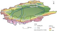
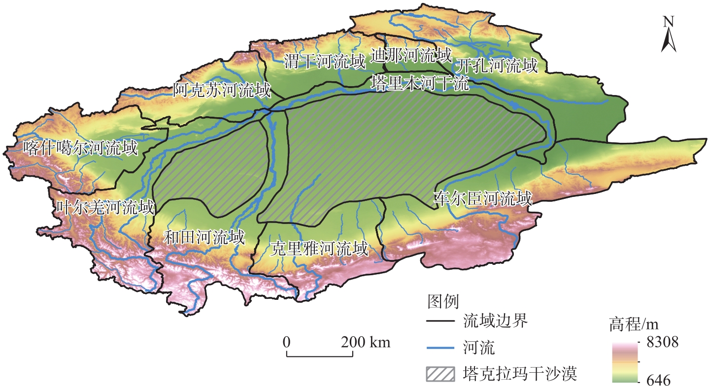
 ), 胡可可1,2,3, 苏里坦1,3(