干旱区地理 ›› 2025, Vol. 48 ›› Issue (8): 1480-1491.doi: 10.12118/j.issn.1000-6060.2024.664 cstr: 32274.14.ALG2024664
赵建文1,2( ), 李金麟1,3(), 王圣杰1,2
收稿日期:2024-10-30
修回日期:2024-12-10
出版日期:2025-08-25
发布日期:2025-08-21
通讯作者:
李金麟(1989-),男,博士,副教授,主要从事寒旱区生态水文方面的研究. E-mail: lijinlin2019@163.com作者简介:赵建文(2001-),男,硕士研究生,主要从事寒旱区生态水文方面的研究. E-mail: zhaojianwen2001@163.com
基金资助:
ZHAO Jianwen1,2(), LI Jinlin1,3(), WANG Shengjie1,2
Received:2024-10-30
Revised:2024-12-10
Published:2025-08-25
Online:2025-08-21
摘要: 土壤水分对植被生长和陆地生态系统至关重要,特别是对干旱半干旱区山地森林生态系统服务供给起着决定性作用。采用遥感土壤水分数据,基于趋势分析和相关性分析、地理探测器等方法探究了2017—2021年祁连山地区土壤水分的时间动态及其空间分异特征,围绕年均气温、年均降水量、归一化植被指数(Normalized difference vegetation index,NDVI)、坡度、坡向、海拔对土壤水分时空分异的影响进行了分析。结果表明:(1)2017—2021年祁连山地区土壤水分变化相对稳定(趋势斜率为0.000018),但年际波动较大(变异系数为0.183)。(2)生长季(5—10月)土壤水分在空间分布上具有显著差异性(0.068~0.214),受东亚季风的影响,土壤水分整体呈现出东高西低的趋势。(3)相关分析和地理探测器的结果均表明,降水量和NDVI对土壤水分时空变化起主导作用,解释力(q)分别为0.761和0.722,均在70%以上,而地形因素影响较小,q值不足0.1。各环境因子对祁连山土壤水分空间分布的影响具有显著性差异,并具有交互作用,呈现双因子增强和非线性增强关系。研究结果可为祁连山地区生态保护政策和措施的制定提供科学依据,促进该地区的生态环境保护。
赵建文, 李金麟, 王圣杰. 祁连山土壤水分时空变化特征及主要驱动因素分析[J]. 干旱区地理, 2025, 48(8): 1480-1491.
ZHAO Jianwen, LI Jinlin, WANG Shengjie. Characteristics of spatial and temporal variation of soil moisture and analysis of main driving factors in the Qilian Mountains[J]. Arid Land Geography, 2025, 48(8): 1480-1491.
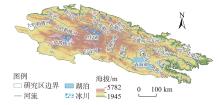
图1
研究区示意图"

图2
祁连山土壤水分时间变化特征"
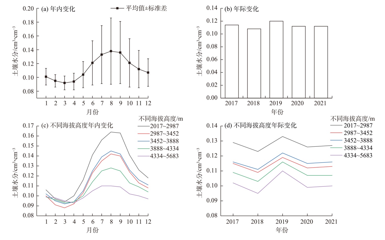
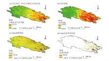
图3
祁连山土壤水分空间变化特征"
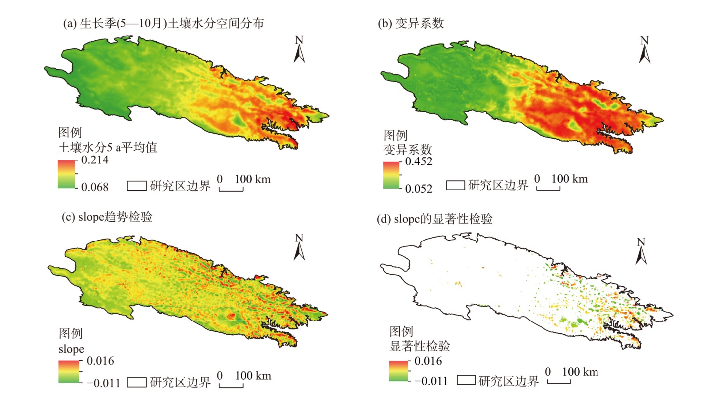
表1
Pearson相关性分析"
| 指标 | 土壤水分 | 年均气温 | 年均降水量 | NDVI | 海拔 | 坡度 | 坡向 |
|---|---|---|---|---|---|---|---|
| 土壤水分 | - | ||||||
| 年均气温 | 0.154** | - | |||||
| 年降水量 | 0.871** | -0.027** | - | ||||
| NDVI | 0.859** | 0.309** | 0.700** | - | |||
| 海拔 | -0.248** | -0.923** | -0.036** | -0.398** | - | ||
| 坡度 | 0.124** | -0.238** | 0.187** | 0.122** | 0.174** | - | |
| 坡向 | -0.083** | 0.039** | -0.089** | -0.081** | 0.005** | -0.051** | - |
图4
土壤水分及影响因子相关性分析 注:NDVI为归一化植被指数。下同。"
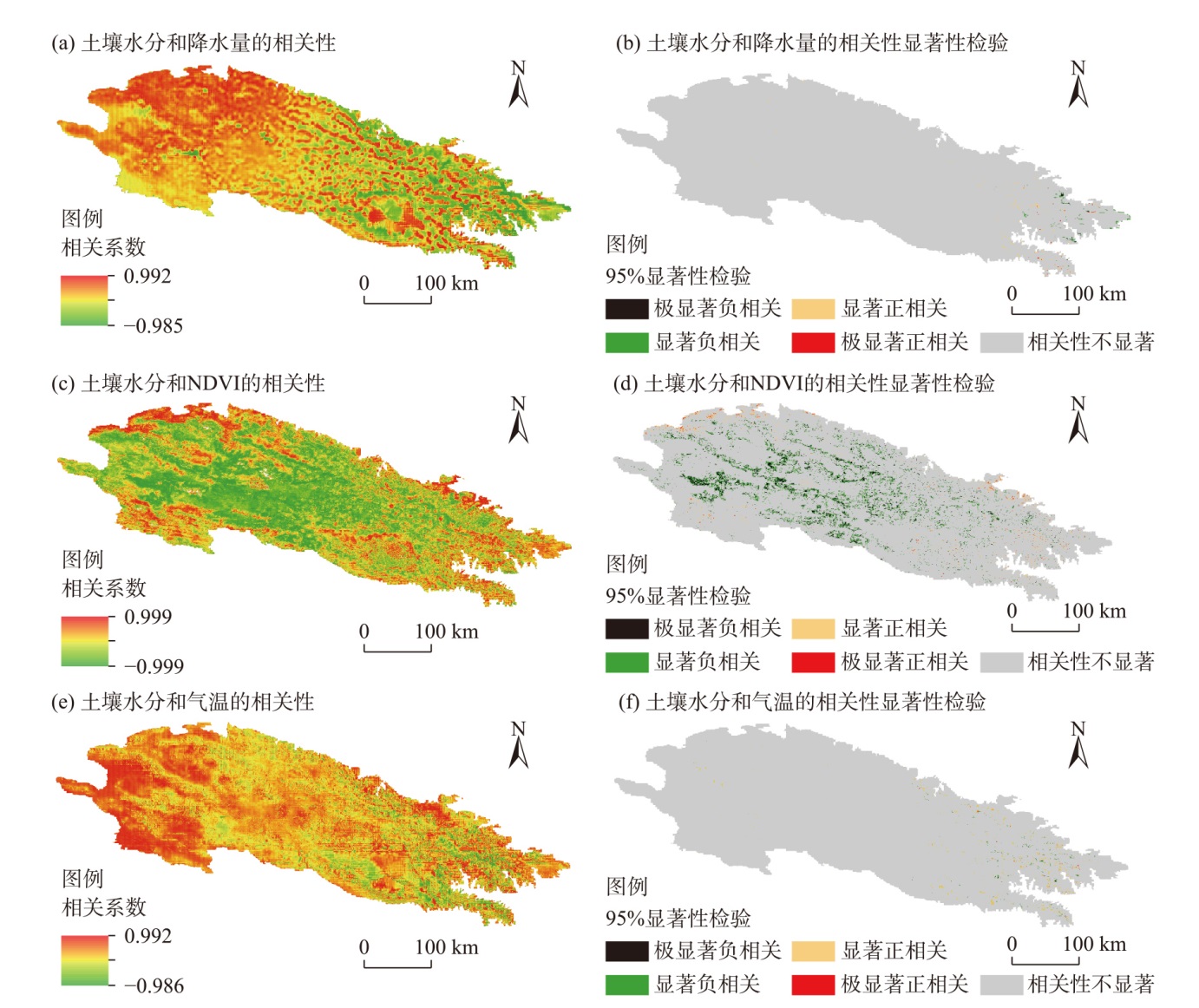
图5
地理探测器结果 注:Y表示存在显著差异。"
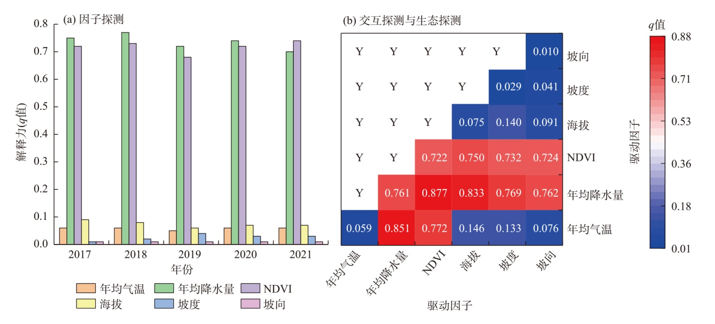
图6
环境因子时间变化"
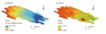
图7
环境因子空间分布"

| [1] | 傅伯杰, 杨志坚, 王仰麟, 等. 黄土丘陵坡地土壤水分空间分布数学模型[J]. 中国科学(D辑:地球科学), 2001, 31(3): 185-191. |
| [Fu Bojie, Yang Zhijian, Wang Yanglin, et al. Mathematical modeling of soil moisture spatial distribution in loess hill slopes[J]. Science in China (Series D: Earth Sciences), 2001, 31(3): 185-191. ] | |
| [2] | 赵伟, 文凤平, 蔡俊飞. 被动微波土壤水分遥感产品空间降尺度研究: 方法、进展及挑战[J]. 遥感学报, 2022, 26(9): 1699-1722. |
| [Zhao Wei, Wen Fengping, Cai Junfei. Methods, progresses, and challenges of passive microwave soil moisture spatial downscaling[J]. National Remote Sensing Bulletin, 2022, 26(9): 1699-1722. ] | |
| [3] |
McColl K A, Alemohammad S H, Akbar R, et al. The global distribution and dynamics of surface soil moisture[J]. Nature Geoscience, 2017, 10(2): 100-104.
doi: 10.1038/NGEO2868 |
| [4] |
朱青, 廖凯华, 赖晓明, 等. 流域多尺度土壤水分监测与模拟研究进展[J]. 地理科学进展, 2019, 38(8): 1150-1158.
doi: 10.18306/dlkxjz.2019.08.004 |
|
[Zhu Qing, Liao Kaihua, Lai Xiaoming, et al. A review of soil water monitoring and modelling across spatial scales in the watershed[J]. Progress in Geography, 2019, 38(8): 1150-1158. ]
doi: 10.18306/dlkxjz.2019.08.004 |
|
| [5] |
Guillod B P, Orlowsky B, Miralles D G, et al. Reconciling spatial and temporal soil moisture effects on afternoon rainfall[J]. Nature Communications, 2015, 6: 6443, doi: 10.1038/ncomms7443.
pmid: 25740589 |
| [6] |
Hsu H, Dirmeyer P A. Soil moisture-evaporation coupling shifts into new gears under increasing CO2[J]. Nature Communications, 2023, 14: 1162, doi: 10.1038/s41467-023-36794-5.
pmid: 36859397 |
| [7] |
Gou Q, Zhu Q. Response of deep soil moisture to different vegetation types in the Loess Plateau of northern Shannxi, China[J]. Scientific Reports, 2021, 11: 15098, doi: 10.1038/s41598-021-94758-5.
pmid: 34302039 |
| [8] | Humphrey V, Berg A, Ciais P, et al. Soil moisture-atmosphere feedback dominates land carbon uptake variability[J]. Nature, 2021, 592: 65-69. |
| [9] |
Li W, Migliavacca M, Forkel M, et al. Widespread increasing vegetation sensitivity to soil moisture[J]. Nature Communications, 2022, 13: 3959, doi: 10.1038/s41467-022-31667-9.
pmid: 35803919 |
| [10] |
Qiao L, Zuo Z, Zhang R, et al. Soil moisture-atmosphere coupling accelerates global warming[J]. Nature Communications, 2023, 14: 4908, doi: 10.1038/s41467-023-40641-y.
pmid: 37582806 |
| [11] |
Zhang K, Wang Q, Chao L, et al. Ground observation-based analysis of soil moisture spatiotemporal variability across a humid to semi-humid transitional zone in China[J]. Journal of Hydrology, 2019, 574: 903-914.
doi: 10.1016/j.jhydrol.2019.04.087 |
| [12] | 郑曼迪, 刘忠, 许昭辉, 等. 基于微波遥感的土壤水分反演估算研究进展[J]. 土壤学报, 2024, 61(1): 16-28. |
| [Zheng Mandi, Liu Zhong, Xu Zhaohui, et al. Research progress of soil moisture estimation based on microwave remote sensing[J]. Acta Pedologica Sinica, 2024, 61(1): 16-28. ] | |
| [13] |
赵天杰. 被动微波反演土壤水分的L波段新发展及未来展望[J]. 地理科学进展, 2018, 37(2): 198-213.
doi: 10.18306/dlkxjz.2018.02.003 |
|
[Zhao Tianjie. Recent advances of L-band application in the passive microwave remote sensing of soil moisture and its prospects[J]. Progress in Geography, 2018, 37(2): 198-213. ]
doi: 10.18306/dlkxjz.2018.02.003 |
|
| [14] | 潘宁, 王帅, 刘焱序, 等. 土壤水分遥感反演研究进展[J]. 生态学报, 2019, 39(13): 4615-4626. |
| [Pan Ning, Wang Shuai, Liu Yanxu, et al. Advances in soil moisture retrieval from remote sensing[J]. Acta Ecologica Sinica, 2019, 39(13): 4615-4626. ] | |
| [15] | 王俊霞, 潘耀忠, 朱秀芳, 等. 土壤水分反演特征变量研究综述[J]. 土壤学报, 2019, 56(1): 23-35. |
| [Wang Junxia, Pan Yaozhong, Zhu Xiufang, et al. A review of researches on inversion of eigenvariance of soil water[J]. Acta Pedologica Sinica, 2019, 56(1): 23-35. ] | |
| [16] |
周磊, 武建军, 张洁. 以遥感为基础的干旱监测方法研究进展[J]. 地理科学, 2015, 35(5): 630-636.
doi: 10.13249/j.cnki.sgs.2015.05.630 |
|
[Zhou Lei, Wu Jianjun, Zhang Jie. Remote sensing-based drought monitoring approach and research progress[J]. Scientia Geographica Sinica, 2015, 35(5): 630-636. ]
doi: 10.13249/j.cnki.sgs.2015.05.630 |
|
| [17] |
Zhou S, Williams A P, Lintner B R, et al. Diminishing seasonality of subtropical water availability in a warmer world dominated by soil moisture-atmosphere feedbacks[J]. Nature Communications, 2022, 13: 5756, doi: 10.1038/s41467-022-33473-9.
pmid: 36180427 |
| [18] | 董金义, 罗敏, 孟凡浩, 等. 蒙古高原土壤水分时空格局演变特征分析[J]. 水土保持研究, 2024, 31(2): 110-121. |
| [Dong Jinyi, Luo Min, Meng Fanhao, et al. Spatiotemporal evolution of soil moisture and its driving forces in the Mongolian Plateau[J]. Research of Soil and Water Conservation, 2024, 31(2): 110-121. ] | |
| [19] | 王坤悦, 李旭红, 余新晓, 等. 北京山区典型植被土壤水分对次降雨的响应[J]. 生态学报, 2024, 44(6): 2561-2571. |
| [Wang Kunyue, Li Xuhong, Yu Xinxiao, et al. Response of soil moisture of typical vegetation to individual rainfall in Beijing mountain area[J]. Acta Ecologica Sinica, 2024, 44(6): 2561-2571. ] | |
| [20] | Li W, Yan D, Weng B, et al. Nonlinear effects of surface soil moisture changes on vegetation greenness over the Tibetan Plateau[J]. Remote Sensing of Environment, 2024, 302: 113971, doi: 10.1016/j.rse.2023.113971. |
| [21] | Thomas A, Yadav B K, Šimůnek J. Water uptake by plants under nonuniform soil moisture conditions: A comprehensive numerical and experimental analysis[J]. Agricultural Water Management, 2024, 292: 108668, doi: 10.1016/j.agwat.2024.108668. |
| [22] | 陈明玉, 邵明安, 李同川, 等. 黄土高原典型切沟土壤水分时空分布特征及其影响因素[J]. 土壤学报, 2021, 58(2): 381-390. |
| [Chen Mingyu, Shao Ming’an, Li Tongchuan, et al. Characteristics and influencing factors of spatiotemporal distribution of soil moisture in typical gully of the Loess Plateau[J]. Acta Pedologica Sinica, 2021, 58(2): 381-390. ] | |
| [23] | 安文明, 韩晓阳, 李宗善, 等. 黄土高原不同植被恢复方式对土壤水分坡面变化的影响[J]. 生态学报, 2018, 38(13): 4852-4860. |
| [An Wenming, Han Xiaoyang, Li Zongshan, et al. Effects of different vegetation restoration types on the slope difference of soil water content in the Loess Plateau, China[J]. Acta Ecologica Sinica, 2018, 38(13): 4852-4860. ] | |
| [24] | 韩新生, 刘广全, 许浩, 等. 宁夏南部半干旱黄土区3种土地利用类型的土壤水分时空变化特征[J]. 水土保持学报, 2022, 36(6): 250-259. |
| [Han Xinsheng, Liu Guangquan, Xu Hao, et al. Temporal and spatial variation characteristics of soil moisture under three land use types in the semi-arid Loess Region of southern Ningxia[J]. Journal of Soil and Water Conservation, 2022, 36(6): 250-259. ] | |
| [25] | 张子慧, 吴世新, 赵子飞, 等. 基于机器学习算法的草地地上生物量估测——以祁连山草地为例[J]. 生态学报, 2022, 42(22): 8953-8963. |
| [Zhang Zihui, Wu Shixin, Zhao Zifei, et al. Estimation of grassland biomass using machine learning methods: A case study of grassland in Qilian Mountains[J]. Acta Ecologica Sinica, 2022, 42(22): 8953-8963. ] | |
| [26] | 车宗玺, 李进军, 汪有奎, 等. 祁连山西段草地土壤温度、水分变化特征[J]. 生态学报, 2018, 38(1): 105-111. |
| [Che Zongxi, Li Jinjun, Wang Youkui, et al. Characteristics of soil temperature and water content variation in the western Qilian Mountains[J]. Acta Ecologica Sinica, 2018, 38(1): 105-111. ] | |
| [27] | 胡健, 吕一河, 傅伯杰, 等. 祁连山排露沟流域土壤水热与降雨脉动沿海拔梯度变化[J]. 干旱区研究, 2017, 34(1): 151-160. |
| [Hu Jian, Lü Yihe, Fu Bojie, et al. Soil hydrothermal variation and rainfall pulses along altitudinal gradient in Pailugou Watershed in the Qilian Mountain[J]. Arid Zone Research, 2017, 34(1): 151-160. ] | |
| [28] |
刘玒玒, 刘书芳. 祁连山地区复合生态系统韧性时空演化及障碍因子识别[J]. 干旱区地理, 2024, 47(2): 237-247.
doi: 10.12118/j.issn.1000-6060.2023.214 |
|
[Liu Honghong, Liu Shufang. Spatiotemporal evolution and obstacle identification of complex ecosystem resilience in the Qilian Mountain area[J]. Arid Land Geography, 2024, 47(2): 237-247. ]
doi: 10.12118/j.issn.1000-6060.2023.214 |
|
| [29] | 张百婷, 李宗省, 冯起, 等. 基于土地利用变化的祁连山地区生态系统服务价值演化分析[J]. 生态学报, 2024, 44(10): 4187-4202. |
| [Zhang Baiting, Li Zongxing, Feng Qi, et al. Evolution of ecosystem service values in Qilian Mountains based on land-use change from 1990 to 2020[J]. Acta Ecologica Sinica, 2024, 44(10): 4187-4202. ] | |
| [30] |
周雪如, 李育. 千百年尺度祁连山地区干湿变化对暖期的响应[J]. 地理学报, 2022, 77(5): 1138-1152.
doi: 10.11821/dlxb202205007 |
|
[Zhou Xueru, Li Yu. Response of dry-wet change to millennial and centennial warm periods in the Qilian Mountains[J]. Acta Geographica Sinica, 2022, 77(5): 1138-1152. ]
doi: 10.11821/dlxb202205007 |
|
| [31] |
张文杰, 程维明, 李宝林, 等. 气候变化下的祁连山地区近40多年冻土分布变化模拟[J]. 地理研究, 2014, 33(7): 1275-1284.
doi: 10.11821/dlyj201407008 |
| [Zhang Wenjie, Chen Weiming, Li Baolin, et al. Simulation of the permafrost distribution on Qilian Mountains over past 40 years under the influence of climate change[J]. Geographical Research, 2014, 33(7): 1275-1284. ] | |
| [32] |
王利辉, 秦翔, 陈记祖, 等. 1961—2013祁连山区冰川年物质平衡重建[J]. 干旱区研究, 2021, 38(6): 1524-1533.
doi: 10.13866/j.azr.2021.06.04 |
|
[Wang Lihui, Qin Xiang, Chen Jizu, et al. Reconstruction of the glacier mass balance in the Qilian Mountains from 1961 to 2013[J]. Arid Zone Research, 2021, 38(6): 1524-1533. ]
doi: 10.13866/j.azr.2021.06.04 |
|
| [33] |
任子健, 王江林, 徐贺年, 等. 祁连山地区过去500 a年代际旱涝事件演化及驱动因素分析[J]. 干旱区地理, 2024, 47(2): 214-227.
doi: 10.12118/j.issn.1000-6060.2023.070 |
|
[Ren Zijian, Wang Jianglin, Xu Henian, et al. Evolution and driving factors of megadrought and pluvial events in the Qilian Mountains during the past 500 years[J]. Arid Land Geography, 2024, 47(2): 214-227. ]
doi: 10.12118/j.issn.1000-6060.2023.070 |
|
| [34] |
薛健, 李宗省, 冯起, 等. 1980—2017年祁连山水源涵养量时空变化特征[J]. 冰川冻土, 2022, 44(1): 1-13.
doi: 10.7522/j.issn.1000-0240.2022.0016 |
|
[Xue Jian, Li Zongxing, Feng Qi, et al. Spatiotemporal variation characteristics of water conservation amount in the Qilian Mountains from 1980 to 2017[J]. Journal of Glaciology and Geocryology, 2022, 44(1): 1-13. ]
doi: 10.7522/j.issn.1000-0240.2022.0016 |
|
| [35] |
孙美平, 马维谦, 姚晓军, 等. 祁连山冰川服务价值评估及其时空特征[J]. 地理学报, 2021, 76(1): 178-190.
doi: 10.11821/dlxb202101014 |
|
[Sun Meiping, Ma Weiqian, Yao Xiaojun, et al. Assessment and spatiotemporal characteristics of service value of glaciers in the Qilian Mountains[J]. Acta Geographica Sinica, 2021, 76(1): 178-190. ]
doi: 10.11821/dlxb202101014 |
|
| [36] | Hu Z, Chai L, Crow W T, et al. Applying a wavelet transform technique to optimize general fitting models for SM analysis: A case study in downscaling over the Qinghai-Tibet Plateau[J]. Remote Sensing, 2022, 14(13): 3063, doi: 10.3390/rs14133063. |
| [37] | Qu Y, Zhu Z, Montzka C, et al. Inter-comparison of several soil moisture downscaling methods over the Qinghai-Tibet Plateau, China[J]. Journal of Hydrology, 2021, 592: 125616, doi: 10.1016/j.jhydrol.2020.125616. |
| [38] |
王劲峰, 徐成东. 地理探测器: 原理与展望[J]. 地理学报, 2017, 72(1): 116-134.
doi: 10.11821/dlxb201701010 |
| [Wang Jinfeng, Xu Chengdong. Geodetector: Principle and prospective[J]. Acta Geographica Sinice, 2017, 72(1): 116-134. ] | |
| [39] |
汪宙峰, 郑博, 贺相綦, 等. 基于参数最优地理探测器的西藏冰湖时空变化与影响因素研究[J]. 冰川冻土, 2023, 45(6): 1950-1960.
doi: 10.7522/j.issn.1000-0240.2023.0149 |
|
[Wang Zhoufeng, Zheng Bo, He Xiangqi, et al. Spatial-temporal variations and influencing factors of glacial lakes in Tibet based on optimal parameters-based geographical detector[J]. Journal of Glaciology and Geocryology, 2023, 45(6): 1950-1960. ]
doi: 10.7522/j.issn.1000-0240.2023.0149 |
|
| [40] |
李丽丽, 杜军, 李亚徽, 等. 2000—2020年祁连山冻土区植被水分利用效率变化特征及其对干旱的响应[J]. 冰川冻土, 2023, 45(2): 688-698.
doi: 10.7522/j.issn.1000-0240.2023.0052 |
|
[Li Lili, Du Jun, Li Yawei, et al. Changes of vegetation water use efficiency and their responding to scPDSI in frozen ground area of the Qilian Mountains from 2000 to 2020[J]. Journal of Glaciology and Geocryology, 2023, 45(2): 688-698. ]
doi: 10.7522/j.issn.1000-0240.2023.0052 |
|
| [41] | 王玉洁, 秦大河. 气候变化及人类活动对西北干旱区水资源影响研究综述[J]. 气候变化研究进展, 2017, 13(5): 483-493. |
| [Wang Yujie, Qin Dahe. Influence of climate change and human activity on water resources in arid region of northwest China: An overview[J]. Climate Change Research, 2017, 13(5): 483-493. ] | |
| [42] | 陈发虎, 谢亭亭, 杨钰杰, 等. 我国西北干旱区“暖湿化”问题及其未来趋势讨论[J]. 中国科学: 地球科学, 2023, 53(6): 1246-1262. |
| [Chen Fahu, Xie Tingting, Yang Yujie, et al. Discussion of the “warming and wetting” trend and its future variation in the drylands of northwest China under global warming[J]. Scientia Sinica (Terrae), 2023, 53(6): 1246-1262. ] | |
| [43] |
丁一汇, 柳艳菊, 徐影, 等. 全球气候变化的区域响应: 中国西北地区气候“暖湿化”趋势、成因及预估研究进展与展望[J]. 地球科学进展, 2023, 38(6): 551-562.
doi: 10.11867/j.issn.1001-8166.2023.027 |
|
[Ding Yihui, Liu Yanju, Xu Ying, et al. Regional responses to global climate change: Progress and prospects for trend, causes, and projection of climatic warming-wetting in northwest China[J]. Advances in Earth Science, 2023, 38(6): 551-562. ]
doi: 10.11867/j.issn.1001-8166.2023.027 |
|
| [44] |
常学尚, 常国乔. 干旱半干旱区土壤水分研究进展[J]. 中国沙漠, 2021, 41(1): 156-163.
doi: 10.7522/j.issn.1000-694X.2020.00067 |
|
[Chang Xueshang, Chang Guoqiao. Advances in research and prospect on soil moisture in arid and semi-arid areas[J]. Journal of Desert Research, 2021, 41(1): 156-163. ]
doi: 10.7522/j.issn.1000-694X.2020.00067 |
|
| [45] | 徐斌, 何宝军, 李宗杰, 等. 高寒山区生长季土壤水分时空变异特征及其影响因素[J]. 生态学报, 2024, 44(18): 8397-8408. |
| [Xu Bin, He Baojun, Li Zongjie, et al. Characteristics of spatio-temporal variability of soil moisture during the growing season in the mountainous alpine area and its influencing factors[J]. Acta Ecologica Sinica, 2024, 44(18): 8397-8408. ] | |
| [46] | 蔺鹏飞, 朱喜, 何志斌, 等. 土壤水分时间稳定性研究进展[J]. 生态学报, 2018, 38(10): 3403-3413. |
| [Lin Pengfei, Zhu Xi, He Zhibin, et al. Research progress on soil moisture temporal stability[J]. Acta Ecologica Sinica, 2018, 38(10): 3403-3413. ] | |
| [47] | 吴晶晶, 焦亮, 张华, 等. 生态修复前后祁连山地区植被覆盖变化[J]. 生态学报, 2023, 43(1): 408-418. |
| [Wu Jingjing, Jiao Liang, Zhang Hua, et al. Vegetation coverage variation in the Qilian Mountains before and after ecological restoration[J]. Acta Ecologica Sinica, 2023, 43(1): 408-418. ] | |
| [48] |
杨斐, 冯祥, 张飞民, 等. 过去40 a来祁连山地区植被变化特征及其与气候的关系[J]. 干旱气象, 2024, 42(3): 385-394.
doi: 10.11755/j.issn.1006-7639(2024)-03-0385 |
| [Yang Fei, Feng Xiang, Zhang Feimin, et al. Characteristics of vegetation change and its relationship with climate in the Qilian Mountains over the past 40 years[J]. Journal of Arid Meteorology, 2024, 42(3): 385-394. ] | |
| [49] |
晋子振, 秦翔, 赵求东, 等. 祁连山西段老虎沟流域消融季径流变化特征研究[J]. 干旱区地理, 2023, 46(2): 178-190.
doi: 10.12118/j.issn.1000-6060.2022.190 |
|
[Jin Zizhen, Qin Xiang, Zhao Qiudong, et al. Characteristics of runoff variation during ablation season in Laohugou watershed of western Qilian Mountains[J]. Arid Land Geography, 2023, 46(2): 178-190. ]
doi: 10.12118/j.issn.1000-6060.2022.190 |
|
| [50] | 付建新, 曹广超, 李玲琴, 等. 1960—2014年祁连山中东段及其附近地区气温时空变化特征[J]. 干旱区研究, 2018, 35(3): 549-561. |
| [Fu Jianxin, Cao Guangchao, Li Lingqin, et al. Spatiotemporal variation of air temperature in the middle and eastern parts of the Qilian Mountains and the nearby regions during the period of 1960—2014[J]. Arid Zone Research, 2018, 35(3): 549-561. ] | |
| [51] | 杨欣, 薛华柱, 董国涛, 等. 1982—2022年祁连山植被变化及其驱动因子[J]. 生态学杂志, 2024, 43(6): 1576-1586. |
| [Yang Xin, Xue Huazhu, Dong Guotao, et al. Vegetation changes and driving factors in the Qilian Mountains during 1982—2022[J]. Chinese Journal of Ecology, 2024, 43(6): 1576-1586. ] |
| [1] | 刘京会, 袁旭山, 李艳敏, 李鑫旭. 基于CMIP6的伊犁河流域极端降水时空特征分析研究[J]. 干旱区地理, 2025, 48(8): 1329-1341. |
| [2] | 张毅明, 汤宇磊, 冯俊波. 基于随机森林模型的青藏高原冰川预测及分析[J]. 干旱区地理, 2025, 48(8): 1342-1352. |
| [3] | 张昕晗, 赵文婷, 焦菊英, 马晓武, 杨波, 凌麒. 1960—2023年黄土高原极端降水事件时空演变特征[J]. 干旱区地理, 2025, 48(7): 1153-1166. |
| [4] | 张晓明, 宿星, 张军, 贾静. 基于PLUS-InVEST模型的甘肃通渭滑坡区生境质量时空变化及预测[J]. 干旱区地理, 2025, 48(7): 1220-1232. |
| [5] | 夏梓洋, 夏云帆, 王宁, 林伟, 马丽娜, 谭晓平, 张艳珍, 焦瑞. 基于POI的天山北坡城市群旅游要素空间格局及影响因素[J]. 干旱区地理, 2025, 48(7): 1243-1254. |
| [6] | 武志平, 姜民, 付建新. 黄河“几”字弯都市圈城镇化高质量发展时空分异及驱动力[J]. 干旱区地理, 2025, 48(7): 1279-1292. |
| [7] | 魏建飞, 袁悠燃, 李强, 董佩佩, 刘玖榕. 黄河流域国土空间效率时空变化及障碍因子分析[J]. 干旱区地理, 2025, 48(6): 1055-1066. |
| [8] | 王佩佩, 王娇, 蔡咏梅. 多尺度视域下中国滑雪场空间分异格局及其驱动因素研究[J]. 干旱区地理, 2025, 48(6): 1080-1088. |
| [9] | 卢晗, 曾永年, 王盼成. 青藏高原东北部实际蒸散发时空变化特征及影响因素[J]. 干旱区地理, 2025, 48(5): 753-764. |
| [10] | 勿吉斯古冷, 那日苏, 丽娜, 银山, 乌云达来, 李明星, 赖韶杰. 2001—2020年呼伦贝尔草原土地沙漠化敏感性时空格局演化[J]. 干旱区地理, 2025, 48(5): 825-837. |
| [11] | 李梦冉, 徐小任, 王梁, 段健, 史舒琪, 任丹丹. 黄河流域农业碳排放时空变化特征及影响因素分析[J]. 干旱区地理, 2025, 48(5): 854-865. |
| [12] | 庞家朋, 李梦园. 中国旅游休闲街区空间差异及成因分析[J]. 干旱区地理, 2025, 48(5): 905-915. |
| [13] | 侯迎, 刘雯惠, 褚阳, 马小娟, 姚诗雨, 倪同欣. 贺兰山东麓绿洲多层次土壤水分亏缺及其影响因素的时空分析[J]. 干旱区地理, 2025, 48(4): 649-660. |
| [14] | 邢梦祥, 郑江华, 李刚勇, 彭建, 凯撒·米吉提, 刘亮, 张建立, 马丽莎, 陆建涛. 2001—2020年塔城地区草地健康时空变化特征及其驱动力分析[J]. 干旱区地理, 2025, 48(4): 673-688. |
| [15] | 闫劲烨, 马正权, 孙萱萱, 阿力木·阿巴斯, 帕丽达·牙合甫. 2015—2023年“乌-昌-石”城市群PM2.5与PM10时空变化及潜在源分析[J]. 干旱区地理, 2025, 48(3): 405-420. |
|
||