Arid Land Geography ›› 2021, Vol. 44 ›› Issue (6): 1763-1771.doi: 10.12118/j.issn.1000–6060.2021.06.24
• Biology and Environment • Previous Articles Next Articles
JIANG Li1,2( ),WEI Tianxing1,2(),LI Yiran1,2,WEI Anqi3
Received:2020-11-02
Revised:2021-07-19
Online:2021-11-25
Published:2021-12-03
Contact:
Tianxing WEI
E-mail:jiangli@bjfu.edu.cn;weitx@bjfu.edu.cn
JIANG Li,WEI Tianxing,LI Yiran,WEI Anqi. Effects of topographical factors on tree species distribution of shelter forest in Loess hilly region of northern Shaanxi[J].Arid Land Geography, 2021, 44(6): 1763-1771.
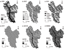
Fig. 1
Extraction results of terrain factor"
Tab. 1
Correspondence between Kappa coefficient and accuracy"
| Kappa系数 | 精度评价 |
|---|---|
| 0.800~1.000 | 几近完美 |
| 0.600~0.800 | 精确 |
| 0.400~0.600 | 较好 |
| 0.200~0.400 | 正常 |
| 0.000~0.200 | 较差 |
| <0.000 | 非常差 |
Tab. 2
Corresponding errors of different mtry parameters"
| 特征数 | 错误率 | |||
|---|---|---|---|---|
| 刺槐 | 山杏 | 油松 | 沙棘 | |
| 1 | 0.231 | 0.209 | 0.196 | 0.229 |
| 2 | 0.218 | 0.200 | 0.177 | 0.219 |
| 3 | 0.207 | 0.195 | 0.172 | 0.215 |
| 4 | 0.208 | 0.193 | 0.169 | 0.214 |
| 5 | 0.204 | 0.188 | 0.166 | 0.214 |
| 6 | 0.203 | 0.186 | 0.170 | 0.213 |
Tab. 3
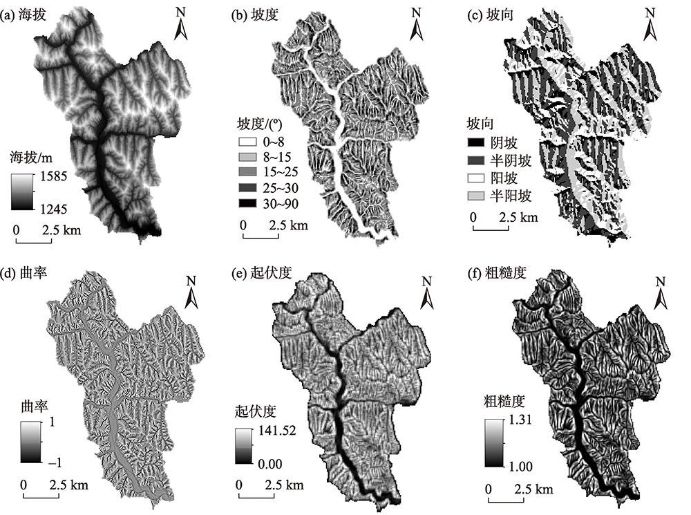
Changes in the distribution area of tree species"
| 赋值 | 变化类型 | 刺槐 | 山杏 | 油松 | 沙棘 | ||||
|---|---|---|---|---|---|---|---|---|---|
| 面积/km2 | 百分比/% | 面积/km2 | 百分比/% | 面积/km2 | 百分比/% | 面积/km2 | 百分比/% | ||
| -3 | Ⅰ 显著减少 | 1.627 | 8.557 | 0.706 | 4.487 | 0.450 | 3.973 | 9.076 | 35.497 |
| -2 | Ⅱ 减少 | 0.358 | 1.882 | 0.811 | 5.159 | 0.137 | 1.212 | 2.451 | 9.585 |
| -1 | Ⅲ 稍减少 | 1.217 | 6.404 | 0.858 | 5.458 | 0.209 | 1.846 | 4.259 | 16.656 |
| 0 | Ⅳ 基本不变 | 1.879 | 9.887 | 1.963 | 12.481 | 1.086 | 9.596 | 3.761 | 14.709 |
| 1 | Ⅴ 稍增加 | 2.304 | 12.123 | 2.176 | 13.837 | 1.161 | 10.258 | 1.826 | 7.141 |
| 2 | Ⅵ 增加 | 3.941 | 20.730 | 4.636 | 29.482 | 2.224 | 19.648 | 2.034 | 7.957 |
| 3 | Ⅶ 显著增加 | 7.683 | 40.419 | 4.576 | 29.096 | 6.051 | 53.466 | 2.162 | 8.457 |
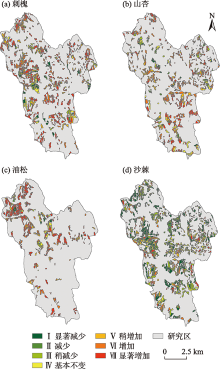
Fig. 2
Changes of tree species distribution"

Tab. 4
Correlation analysis between tree species distribution and topographical factors"
| 树种 | 粗糙度 | 海拔 | 曲率 | 坡度 | 起伏度 | 坡向 |
|---|---|---|---|---|---|---|
| 刺槐 | -0.020 | 0.087** | 0.033* | -0.026 | -0.028 | -0.008 |
| 山杏 | -0.028 | 0.153** | 0.011 | -0.035* | -0.039* | 0.108** |
| 油松 | 0.052** | 0.002 | -0.039 | 0.053** | 0.048* | -0.003 |
| 沙棘 | 0.015 | -0.031* | -0.048** | 0.020 | 0.031* | 0.047** |
Tab. 5
Importance of variables to sample points in different regions"
| 地形因子 | 刺槐 | 山杏 | 油松 | 沙棘 | ||||
|---|---|---|---|---|---|---|---|---|
| 无树木分布 | 有树木分布 | 无树木分布 | 有树木分布 | 无树木分布 | 有树木分布 | 无树木分布 | 有树木分布 | |
| 海拔 | 148.400 | 197.420 | 150.380 | 177.820 | 133.810 | 64.572 | 33.054 | 175.550 |
| 坡度 | 30.620 | 52.054 | 24.813 | 40.814 | 34.691 | 37.926 | 38.650 | 44.833 |
| 坡向 | 113.890 | 72.196 | 117.700 | 217.450 | 86.055 | 122.800 | 198.240 | 206.110 |
| 曲率 | 5.973 | 44.247 | 4.350 | 34.044 | 13.792 | 27.561 | 6.939 | 54.817 |
| 起伏度 | 11.449 | 54.782 | 19.990 | 42.130 | 34.848 | 32.115 | 40.107 | 47.462 |
| 粗糙度 | 38.066 | 67.327 | 35.679 | 42.943 | 33.769 | 35.709 | 54.792 | 58.836 |
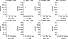
Fig. 3
Importance index ranking of topographical factors"
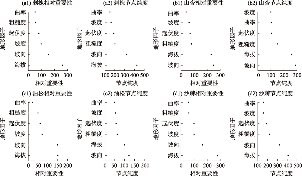
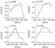
Fig. 4
Effect of altitude on tree species"
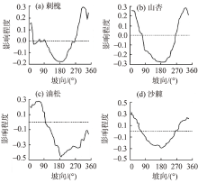
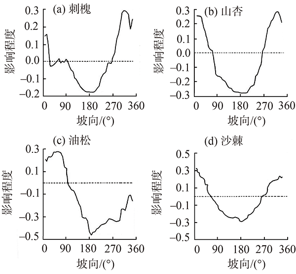
Fig. 5
Effect of aspect on tree species"
| [1] | Sun W Y, Song X Y, Mu X M, et al. Spatiotemporal vegetation cover variations associated with climate change and ecological restoration in the Loess Plateau[J]. Agricultural and Forest Meteorology, 2015, 209-210. |
| [2] | 朱教君. 防护林学研究现状与展望[J]. 植物生态学报, 2013, 9(37):872-888. |
| [ Zhu Jiaojun. A review of the present situation and future prospect of science of protective forest[J]. Chinese Journal of Plant Ecology, 2013, 9(37):872-888. ] | |
| [3] | 张翀, 白子怡, 李学梅, 等. 2001—2018年黄土高原植被覆盖人为影响时空演变及归因分析[J]. 干旱区地理, 2021, 44(1):188-196. |
| [ Zhang Chong, Bai Ziyi, Li Xuemei, et al. Spatio-temporal evolution and attribution analysis of human effects of vegetation cover on the Loess Plateau from 2001 to 2018[J]. Arid Land Geography, 2021, 44(1):188-196. ] | |
| [4] | 岳辉, 刘英. 近15 a陕西省植被时空变化与影响因素分析[J]. 干旱区地理, 2019, 42(2):314-323. |
| [ Yue Hui, Liu Ying. Vegetation spatiotemporal variation and its driving factors of Shaanxi Province in recent 15 year[J]. Arid Land Geography, 2019, 42(2):314-323. ] | |
| [5] | Chase J M, Leibold M A. Ecological niches: Linking classical and contemporary approaches[M]. Chicago: University of Chicago Press, 2003. |
| [6] |
Pelletier J, Chidumayo E, Trainor A, et al. Distribution of tree species with high economic and livelihood value for Zambia[J]. Forest Ecology and Management, 2019, 441:280-292.
doi: 10.1016/j.foreco.2019.03.051 |
| [7] |
Zhang C, Li X, Chen L, et al. Effects of topographical and edaphic factors on tree community structure and diversity of subtropical mountain forests in the lower Lancang River Basin[J]. Forests, 2016, 7(12):222, doi: 10.3390/f7100222.
doi: 10.3390/f7100222 |
| [8] | 秦景秀, 郝兴明, 张颖, 等. 气候变化和人类活动对干旱区植被生产力的影响[J]. 干旱区地理, 2020, 43(1):117-125. |
| [ Qin Jingxiu, Hao Xingming, Zhang Ying, et al. Effects of climate change and human activities on vegetation productivity in arid areas[J]. Arid Land Geography, 2020, 43(1):117-125. ] | |
| [9] |
Amissah L, Mohren G M J, Bongers F, et al. Rainfall and temperature affect tree species distribution in Ghana[J]. Journal of Tropical Ecology, 2014, 30(5):435-446.
doi: 10.1017/S026646741400025X |
| [10] |
Wang W J, He H S, Thompson F R, et al. Changes in forest biomass and tree species distribution under climate change in the northeastern United States[J]. Landscape Ecology, 2017, 32(7):1399-1413.
doi: 10.1007/s10980-016-0429-z |
| [11] |
Pelletier J, Chidumayo E, Trainor A, et al. Distribution of tree species with high economic and livelihood value for Zambia[J]. Forest Ecology and Management, 2019, 441:280-292.
doi: 10.1016/j.foreco.2019.03.051 |
| [12] | 晏寒冰, 彭丽潭, 唐旭清. 基于气候变化的东北地区森林树种分布预测建模与影响分析[J]. 林业科学, 2014, 50(5):132-139. |
| [ Yan Hanbing, Peng Litan, Tang Xuqing. Modeling and impact analysis on distribution prediction of forest tree species in northeast China based on climate change[J]. Scientia Silvae Sinicae, 2014, 50(5):132-139. ] | |
| [13] | 曹伟, 郑美林, 刘童燕. 东北地区主要树种分布与气候的关系[J]. 干旱区资源与环境, 2013, 27(3):132-136. |
| [ Cao Wei, Zheng Meilin, Liu Tongyan. The relationship between climate and distribution of main trees in the north-east China[J]. Journal of Arid Land Resources and Environment, 2013, 27(3):132-136. ] | |
| [14] | 张晓玮, 王婧如, 王明浩, 等. 中国云杉属树种地理分布格局的主导气候因子[J]. 林业科学, 2020, 56(4):1-11. |
| [ Zhang Xiaowei, Wang Jingru, Wang Minghao, et al. Dominant climatic factors influencing the geographical distribution pattern of Picea in China[J]. Scientia Silvae Sinicae, 2020, 56(4):1-11. ] | |
| [15] | 刘秋锋, 康慕谊, 刘全儒. 中条山东段森林乔木树种分布的环境梯度分析与种组划分[J]. 生态学杂志, 2006, 25(11):1306-1311. |
| [ Liu Qiufeng, Kang Muyi, Liu Quanru. Environmental gradient analysis and species group division of tree species distribution in eastern Zhongtiao Mountain[J]. Chinese Journal of Ecology, 2006, 25(11):1306-1311. ] | |
| [16] |
布仁仓, 常禹, 胡远满, 等. 小兴安岭针叶树种在不同尺度上对环境因子的敏感性分析[J]. 植物生态学报, 2008, 32(1):80-87.
doi: 10.3773/j.issn.1005-264x.2008.01.009 |
|
[ Bu Rencang, Chang Yu, Hu Yuanman, et al. Sensitivity of coniferous trees to environmental factors at different scales in the small Xing’an Mountains China[J]. Chinese Journal of Plant Ecology, 2008, 32(1):80-87. ]
doi: 10.3773/j.issn.1005-264x.2008.01.009 |
|
| [17] | 邵方丽, 余新晓, 郑江坤, 等. 北京山区防护林优势树种分布与环境的关系[J]. 生态学报, 2012, 32(19):6092-6099. |
| [ Shao Fangli, Yu Xinxiao, Zheng Jiangkun, et al. Relationships between dominant arbor species distribution and environmental factors of shelter forests in the Beijing mountain area[J]. Acta Ecologica Sinica, 2012, 32(19):6092-6099. ] | |
| [18] |
谢玉彬, 马遵平, 杨庆松, 等. 基于地形因子的天童地区常绿树种和落叶树种共存机制研究[J]. 生物多样性, 2012, 20(2):159-167.
doi: 10.3724/SP.J.1003.2012.09242 |
|
[ Xie Yubin, Ma Zunping, Yang Qingsong, et al. Coexistence mechanisms of evergreen and deciduous trees based on topographic factors in Tiantong region, Zhejiang Province, eastern China[J]. Biodiversity Science, 2012, 20(2):159-167. ]
doi: 10.3724/SP.J.1003.2012.09242 |
|
| [19] |
王琛智, 张朝, 张静, 等. 湖南省地形因素对水稻生产的影响[J]. 地理学报, 2018, 73(9):1792-1808.
doi: 10.11821/dlxb201809014 |
|
[ Wang Chenzhi, Zhang Zhao, Zhang Jing, et al. The effect of terrain factors on rice production: A case study in Hunan Province[J]. Acta Geographica Sinica, 2018, 73(9):1792-1808. ]
doi: 10.11821/dlxb201809014 |
|
| [20] | 魏安琪. 陕西吴起退耕还林植被恢复及常见造林树种适生性研究[D]. 北京: 北京林业大学, 2019. |
| [ Wei Anqi. Study on vegetation restoration and adaptability of common afforestation tree species in converted farmland to forestry region: A case of Wuqi County, Shaanxi Province[D]. Beijing: Beijing Forestry University, 2019. ] | |
| [21] |
Breiman L. Statistical modeling: The two cultures[J]. Statistical Science, 2001, 16(3):199-215.
doi: 10.1214/ss/1009213725 |
| [22] | 张雷, 王琳琳, 张旭东, 等. 随机森林算法基本思想及其在生态学中的应用——以云南松分布模拟为例[J]. 生态学报, 2014, 34(3):650-659. |
| [ Zhang Lei, Wang Linlin, Zhang Xudong, et al. The basic principle of random forest and its applications in ecology: A case study of Pinus yunnanensis[J]. Acta Ecologica Sinica, 2014, 34(3):650-659. ] | |
| [23] | 蒋云姣, 胡曼, 李明阳, 等. 县域尺度森林地上生物量遥感估测方法研究[J]. 西南林业大学学报, 2015, 35(6):53-59. |
| [ Jiang Yunjiao, Hu Man, Li Mingyang, et al. Remote sensing based estimation of forest aboveground biomass at county level[J]. Journal of Southwest Forestry University, 2015, 35(6):53-59. ] | |
| [24] |
Cutler D R, Edwards T C, Beard K H, et al. Random forests for classification in ecology[J]. Ecology, 2007, 88(11):2783-2792.
doi: 10.1890/07-0539.1 |
| [25] |
Landis J R, Koch G G. The measurement of observer agreement for categorical data[J]. Biometrics, 1977, 33(1):159-174.
pmid: 843571 |
| [26] | Viechtbauer W. Conducting meta-analyses in R with the metafor package[J]. Journal of Statistical Software, 2010, 36(3):1-48. |
| [27] | 周文洁, 魏天兴, 刘广全, 等. 陕北典型退耕地沙棘群落与土壤因子的耦合关系[J]. 中国水土保持科学, 2020, 18(2):1-9. |
| [ Zhou Wenjie, Wei Tianxing, Liu Guangquan, et al. Coupling relationship between Hippophae rhamnoides community and soil factor intypical returning farmland to forest area in northern Shaanxi Province[J]. Science of Soil and Water Conservation, 2020, 18(2):1-9. ] | |
| [28] |
高海东, 庞国伟, 李占斌, 等. 黄土高原植被恢复潜力研究[J]. 地理学报, 2017, 72(5):863-874.
doi: 10.11821/dlxb201705008 |
|
[ Gao Haidong, Pang Guowei, Li Zhanbin, et al. Evaluating the potential of vegetation restoration in the Loess Plateau[J]. Acta Geographica Sincia, 2017, 72(5):863-874. ]
doi: 10.11821/dlxb201705008 |
|
| [29] | 张晓梅, 邸利, 史再军, 等. 甘肃泾川中沟小流域不同坡位刺槐人工林土壤水分特征[J]. 干旱区研究, 2019, 36(5):1300-1308. |
| [ Zhang Xiaomei, Di Li, Shi Zaijun, et al. Soil moisture content under artificial Robinnia pseudoacacia forest at different slope positions in the Zhonggou Minor Basin, Jingchuan County, Gansu Province[J]. Arid Zone Research, 2019, 36(5):1300-1308. ] | |
| [30] | 韦景树, 李宗善, 焦磊, 等. 黄土高原羊圈沟小流域人工物种和自然物种径向生长对气候变化的响应差异[J]. 生态学报, 2018, 38(22):8040-8050. |
| [ Wei Jingshu, Li Zhongshan, Jiao Lei, et al. Climate effect on the radial growth of introduced and native tree species in the Yangjuangou catchment of the Loess Plateau[J]. Acta Ecologica Sinica, 2018, 38(22):8040-8050. ] | |
| [31] | 张希彪, 上官周平, 王金成, 等. 子午岭人工油松林群落更新特征及影响因子[J]. 山地学报, 2014, 32(5):561-567. |
| [ Zhang Xibiao, Shangguan Zhouping, Wan Jincheng, et al. The regeneration characteristics and affecting factors of Pinus tabulaeformis artificial forests of Ziwu Mountains, China[J]. Mountain Research, 2014, 32(5):561-567. ] | |
| [32] | 唐洋, 温仲明, 刘静, 等. 黄土丘陵区刺槐对不同立地环境的适应机制[J]. 水土保持通报, 2019, 39(5):46-53. |
| [ Tang Yang, Wen Zhongming, Liu Jing, et al. Adaptation mechanism of Robinia pseudoacacia under different site conditions in Loess Hill and Gully Region[J]. Bulletin of Soil and Water Conservation, 2019, 39(5):46-53. ] | |
| [33] | 焦醒, 刘广全. 陕西黄土高原油松生长状况及其影响因子分析[J]. 西北植物学报, 2009, 29(5):1026-1032. |
| [ Jiao Xing, Liu Guangquan. Growth and its influencing factors of Pinus tabulaeformis in the Loess Plateau of Shaanxi Province[J]. Acta Botanica Boreali-Occidentalia Sinica, 2009, 29(5):1026-1032. ] | |
| [34] | 张恰咛, 朱清科, 任正龑, 等. 地形对陕北黄土区衰退沙棘人工林天然更新的影响[J]. 林业科学研究, 2017, 30(2):300-306. |
| [ Zhang Qianing, Zhu Qingke, Ren Zhengyan, et al. Modeling the effects of topography on the natural renewal of declining sea-buckthorn forest in Loess Plateau of northern Shaanxi Province[J]. Forest Research, 2017, 30(2):300-306. ] | |
| [35] | 姜准, 刘丹一, 陈贝贝, 等. 中国沙棘克隆生长对造林密度的早期响应及其生物量分配调节机制[J]. 林业科学, 2017, 53(10):29-39. |
| [ Jiang Zhun, Liu Danyi, Chen Beibei, et al. Clonal growth of Hippophae rhamniodes ssp sinensis at the early stage in response to initial planting density and its regulation mechanism of biomass allocation[J]. Scientia Silvae Sinicae, 2017, 53(10):29-39. ] | |
| [36] | 聂恺宏, 邹旭, 吉生丽, 等. 中国沙棘克隆生长对灌水强度的响应规律及其激素调控机制[J]. 生态学报, 2018, 38(14):4942-4952. |
| [ Nie Kaihong, Zou Xu, Ji Shengli, et al. Clonal growth response of Hippophae rhamnoides ssp sinensis to irrigation intensity and its hormone regulation mechanism[J]. Acta Ecologica Sinica, 2018, 38(14):4942-4952. ] |
|
||