Arid Land Geography ›› 2023, Vol. 46 ›› Issue (7): 1155-1165.doi: 10.12118/j.issn.1000-6060.2022.473
• Ecology and Environment • Previous Articles Next Articles
TIAN Liulan1( ),WANG Shanshan2,WU Zhaopeng1,3()
Received:2022-09-20
Revised:2022-10-25
Online:2023-07-25
Published:2023-08-03
TIAN Liulan, WANG Shanshan, WU Zhaopeng. Construction of ecological security pattern in Urumqi based on multi-temporal remote sensing data[J].Arid Land Geography, 2023, 46(7): 1155-1165.

Fig. 1
Schematic diagram of the study area"

Tab. 1
Evaluation indices and weights of ecological land"
| 决策目标 | 评价因素层 | 指标层 | 参评因子 | 全局权重 |
|---|---|---|---|---|
| 生态用地评价 | 生态系统服务重要性评价 | 生物多样性保护 | 植被覆盖度 | 0.0149 |
| 降雨量与气温 | 0.0238 | |||
| 净初级生产力 | 0.0425 | |||
| 高程 | 0.0112 | |||
| 水资源 | 距水库、湖泊距离 | 0.1039 | ||
| 距五级河流距离 | 0.1039 | |||
| 地形 | 地形位指数 | 0.0975 | ||
| 坡向 | 0.0488 | |||
| 人类活动干扰 | 距建设用地距离 | 0.0357 | ||
| 人口聚集度 | 0.0178 | |||
| 生态敏感性评价 | 水土流失 | 土地利用 | 0.0282 | |
| 降雨量 | 0.0445 | |||
| 地形起伏度 | 0.1735 | |||
| 土壤质地 | 0.0184 | |||
| 植被覆盖度 | 0.1103 | |||
| 土壤侵蚀 | 坡长坡度 | 0.0061 | ||
| 水土保持措施 | 0.0368 | |||
| 降雨侵蚀力 | 0.0094 | |||
| 土壤可蚀性 | 0.0148 | |||
| 植被覆盖与管理 | 0.0578 |
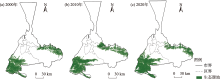
Fig. 2
Distributions of ecological sources from 2000 to 2020"

Tab. 2
Statistical results of ecological source areas from 2000 to 2020"
| 年份 | 面积/km2 | 占比/% |
|---|---|---|
| 2000 | 2640.35 | 18.94 |
| 2010 | 2882.54 | 20.67 |
| 2020 | 3085.98 | 22.13 |
Tab. 3
Index system of ecological resistance and weight of classification standard"
| 阻力因子 | 相对阻力系数 | 权重 | |||||
|---|---|---|---|---|---|---|---|
| 1 | 2 | 3 | 4 | 5 | 6 | ||
| 坡度/(°) | ≤2 | (2, 6] | (6, 15] | (15, 20] | (20, 25] | >25 | 0.14 |
| 土地利用类型 | 林地 | 草地 | 耕地 | 水体 | 建设用地 | 未利用地 | 0.52 |
| 植被覆盖度 | >0.79 | (0.67, 0.79] | (0.56, 0.67] | (0.47, 0.56] | (0.41, 0.47] | ≤0.41 | 0.18 |
| 高程/m | >4000 | (3000, 4000] | (2000, 3000] | (1000, 2000] | (500, 1000] | ≤500 | 0.16 |
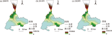
Fig. 3
Minimum cumulative resistance surface from 2000 to 2020"

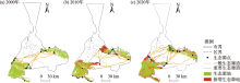
Fig. 4
Distributions of ecological corridors and new ecological source sites from 2000 to 2020"


Fig. 5
Spatial distributions of ecological security pattern from 2000 to 2020"

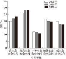
Fig. 6
Change of ecological security space grade from 2000 to 2020"
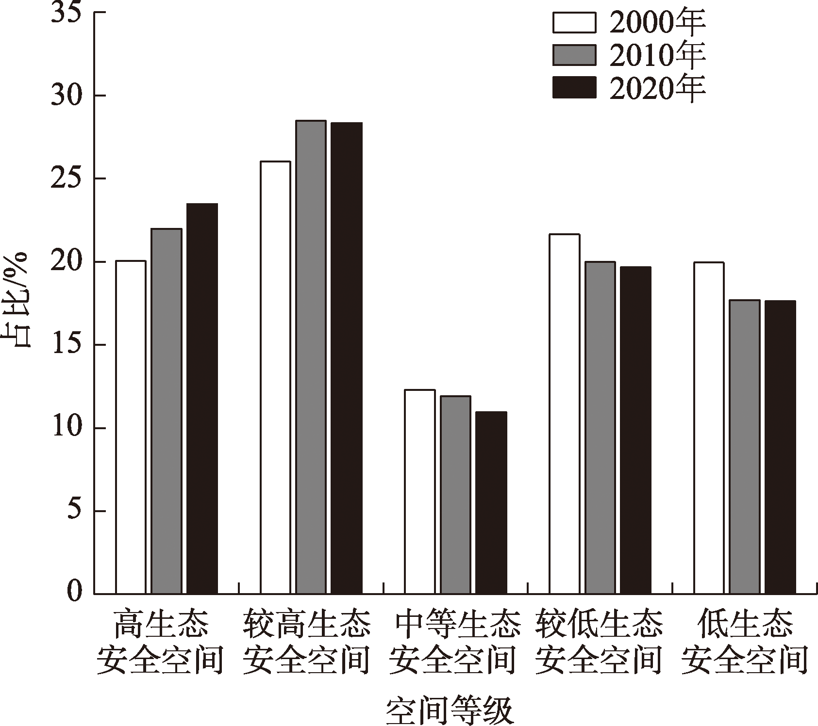
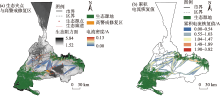
Fig. 7
Spatial distributions of ecological pinch points and high alert restoration areas"

| [1] | 李航鹤, 马腾辉, 王坤, 等. 基于最小累积阻力模型(MCR)和空间主成分分析法(SPCA)的沛县北部生态安全格局构建研究[J]. 生态与农村环境学报, 2020, 36(8): 1036-1045. |
| [Li Hanghe, Ma Tenghui, Wang Kun, et al. Construction of ecological security pattern in northern Peixian based on MCR and SPCA[J]. Journal of Ecology and Rural Environment, 2020, 36(8): 1036-1045.] | |
| [2] |
王根绪, 程国栋, 钱鞠. 生态安全评价研究中的若干问题[J]. 应用生态学报, 2003, 14(9): 1551-1556.
pmid: 14733019 |
|
[Wang Genxu, Cheng Guodong, Qian Ju. Several problems in ecological security assessment research[J]. Chinese Journal of Applied Ecology, 2003, 14(9): 1551-1556.]
pmid: 14733019 |
|
| [3] | 朱强, 俞孔坚, 李迪华. 景观规划中的生态廊道宽度[J]. 生态学报, 2005, 35(9): 2406-2412. |
| [Zhu Qiang, Yu Kongjian, Li Dihua. The width of ecological corridor in landscape planning[J]. Acta Ecologica Sinica, 2005, 35(9): 2406-2412.] | |
| [4] | 何子张, 施艳琦, 林云萍, 等. 面向规划统筹的厦门国土空间生态修复规划探索[J]. 规划师, 2020, 36(17): 13-19. |
| [He Zizhang, Shi Yanqi, Lin Yunping, et al. Planning integration oriented Xiamen land and space ecological restoration planning[J]. Planners, 2020, 36(17): 13-19.] | |
| [5] | Yu K J. Security patterns and surface model in landscape ecological planning[J]. Landscape & Urban Planning, 1996, 36(1): 1-17. |
| [6] |
蒙吉军, 燕群, 向芸芸. 鄂尔多斯土地利用生态安全格局优化及方案评价[J]. 中国沙漠, 2014, 34(2): 590-596.
doi: 10.7522/j.issn.1000-694X.2013.00352 |
|
[Meng Jijun, Yan Qun, Xiang Yunyun. The optimization of ecological security pattern based on land use and assessment of schemes in Ordos, Inner Mongolia, China[J]. Journal of Desert Research, 2014, 34(2): 590-596.]
doi: 10.7522/j.issn.1000-694X.2013.00352 |
|
| [7] | 薛强, 路路, 牛韧, 等. 基于地质灾害敏感性的生态安全格局关键区识别与修复——以济南市为例[J]. 生态学报, 2021, 41(22): 9050-9063. |
| [Xue Qiang, Niu Ren, et al. Identification and restoration of key areas of ecological security pattern based on sensitivity to geological disasters: A case study of Jinan City[J]. Acta Ecologica Sinica, 2021, 41(22): 9050-9063.] | |
| [8] | 付凤杰, 刘珍环, 刘海. 基于生态安全格局的国土空间生态修复关键区域识别——以贺州市为例[J]. 生态学报, 2021, 41(9): 3406-3414. |
| [Fu Fengjie, Liu Zhenhuan, Liu Hai. Identifying key areas of ecosystem restoration for territorial space based on ecological security pattern: A case study in Hezhou City[J]. Acta Ecologica Sinica, 2021, 41(9): 3406-3414.] | |
| [9] | 刘顺鑫, 黄云. “三生空间”视角下万州区景观生态安全评价及其耦合特征分析[J]. 水土保持研究, 2020, 27(6): 308-316. |
| [Liu Shunxin, Huang Yun. Valuation and coupling coordination analysis of landscape ecological security of Wanzhou district from the perspective of production-life-ecological space[J]. Research of Soil and Water Conservation, 2020, 27(6): 308-316.] | |
| [10] | 刘晓阳, 曾坚, 贾梦圆, 等. 闽三角城市群生态安全格局构建及城镇扩展模拟[J]. 生态学报, 2020, 40(21): 7873-7885. |
| [Liu Xiaoyang, Zeng Jian, Jia Mengyuan, et al. Construction of ecological security pattern and simulation of urban sprawl in the urban agglomeration of Min Delta[J]. Acta Ecologica Sinica, 2020, 40(21): 7873-7885.] | |
| [11] | 吴金华, 刘思雨, 白帅. 基于景观生态安全的神木市生态廊道识别与优化[J]. 干旱区研究, 2021, 38(4): 1120-1127. |
| [Wu Jinhua, Liu Siyu, Bai Shuai. Identification and optimization of ecological corridors in Shenmu City based on landscape ecological security[J]. Arid Zone Research, 2021, 38(4): 1120-1127.] | |
| [12] |
张学渊, 魏伟, 颉斌斌, 等. 西北干旱区生态承载力监测及安全格局构建[J]. 自然资源学报, 2019, 34(11): 2389-2402.
doi: 10.31497/zrzyxb.20191111 |
|
[Zhang Xueyuan, Xie Binbin, et al. Ecological carrying capacity monitoring and security pattern construction in arid areas of northwest China[J]. Journal of Natural Resources, 2019, 34(11): 2389-2402.]
doi: 10.31497/zrzyxb.20191111 |
|
| [13] | 马才学, 杨蓉萱, 柯新利, 等. 基于生态压力视角的长三角地区生态安全格局构建与优化[J]. 长江流域资源与环境, 2022, 31(1): 135-147. |
| [Ma Caixue, Yang Rongxuan, Ke Xinli, et al. Construction and optimization of ecological security pattern in Yangtze River Delta based on the perspective of ecological pressure[J]. Resources and Environment in the Yangtze Basin, 2022, 31(1): 135-147.] | |
| [14] | 李鹏辉, 徐丽萍, 刘笑, 等. 基于三维生态足迹模型的天山北麓绿洲生态安全评价[J]. 干旱区研究, 2020, 37(5): 1337-1345. |
| [Li Penghui, Xu Liping, Liu Xiao, et al. Ecological security evaluation of an oasis in the north of the Tianshan Mountains based on three-dimensional ecological footprint model[J]. Arid Zone Research, 2020, 37(5): 1337-1345.] | |
| [15] | 杨雪荻, 白永平, 车磊, 等. 甘肃省生态安全时空演变特征及影响因素解析[J]. 生态学报, 2020, 40(14): 4785-4793. |
| [Yang Xuedi, Bai Yongping, Che Lei, et al. Spatio-temporal evolution and influencing factors of ecological security pattern in Gansu Province[J]. Acta Ecologica Sinica, 2020, 40(14): 4785-4793.] | |
| [16] | 董媛媛. 基于“生态要素-DPSIRM”生态安全评价体系的构建[J]. 水土保持研究, 2020, 27(5): 333-339. |
| [Dong Yuanyuan. Construction of ecological safety evaluation system based on ‘ecological elements: DPSIRM’[J]. Research of Soil and Water Conservation, 2020, 27(5): 333-339.] | |
| [17] |
雷金睿, 陈宗铸, 陈毅青, 等. 1990—2018年海南岛湿地景观生态安全格局演变[J]. 生态环境学报, 2020, 29(2): 293-302.
doi: 10.16258/j.cnki.1674-5906.2020.02.010 |
|
[Lei Jinrui, Chen Zongzhu, Chen Yiqing, et al. Dynamic analysis of wetland landscape ecological security pattern of Hainan Island in 1990—2018[J]. Ecology and Environmental Sciences, 2020, 29(2): 293-302.]
doi: 10.16258/j.cnki.1674-5906.2020.02.010 |
|
| [18] | 张瑾青, 罗涛, 徐敏, 等. 闽三角地区城镇空间扩张对区域生态安全格局的影响[J]. 生态学报, 2020, 40(15): 5113-5123. |
| [Zhang Jinqing, Luo Tao, Xu Min, et al. Influence of urban spatial expansion on the regionally ecological security pattern in Min-Delta region[J]. Acta Ecologica Sinica, 2020, 40(15): 5113-5123.] | |
| [19] | 哈力木拉提·阿布来提, 阿里木江·卡斯木, 祖拜旦·阿克木. 基于形态学空间格局分析法和MCR模型的乌鲁木齐市生态网络构建[J]. 中国水土保持科学, 2021, 19(5): 106-114. |
| [Abulaiti Halimulati, Kasimu Alimujiang, Akemu Zubaidan. Construction and optimization of Urumqi ecological network based on the morphological spatial pattern analysis and MCR model[J]. Science of Soil and Water Conservation, 2021, 19(5): 106-114.] | |
| [20] | 王珊珊, 毋兆鹏. 基于生态安全的乌鲁木齐市土地利用冲突识别[J]. 湖北农业科学, 2022, 61(1): 46-53. |
| [Wang Shanshan, Wu Zhaopeng. Identification of land use conflicts based on ecological security in Urumqi City[J]. Hubei Agricultural Sciences, 2022, 61(1): 46-53.] | |
| [21] | 林晋大, 多玲花, 邹自力. 城市扩张背景下景观破碎化动态演变及空间自相关分析——以南昌市为例[J]. 水土保持研究, 2022, 29(4): 362-369. |
| [Lin Jinda, Duo Linghua, Zou Zili. Dynamic evolution and spatial autocorrelation analysis of landscape fragmentation under the background of urban expansion: A case study of Nanchang City[J]. Research of Soil and Water Conservation, 2022, 29(4): 362-369.] | |
| [22] |
Knaapen J P, Scheffer M, Harms B. Estimating habitat isolation in landscape planning[J]. Landscape and Urban Planning, 1992, 23(1): 1-16.
doi: 10.1016/0169-2046(92)90060-D |
| [23] | McRae B H, Dickson B G, Keitt T H, et al. Using circuit theory to model connectivity in ecology, evolution, and conservation[J]. Ecology, 2008, 10: 2712-2724. |
| [24] | 郑群明, 申明智, 钟林生. 普达措国家公园生态安全格局构建[J]. 生态学报, 2021, 41(3): 874-885. |
| [Zheng Qunming, Shen Mingzhi, Zhong Linsheng. Construction of ecological security pattern in Pudacuo National Park[J]. Acta Ecologica Sinica, 2021, 41(3): 874-885.] | |
| [25] | 张萌, 刘吉平, 赵丹丹. 吉林省西部生态安全格局构建[J]. 干旱区地理, 2021, 44(6): 1676-1685. |
| [Zhang Meng, Liu Jiping, Zhao Dandan. Construction of ecological security pattern in western Jilin Province[J]. Arid Land Geography, 2021, 44(6): 1676-1685.] | |
| [26] | Wang G, Cheng G, Ju Q. Several problems in ecological security assessment research[J]. Chinese Journal of Applied Ecology, 2003, 14(9): 1551-1556. |
| [27] | 王晓峰, 吕一河, 傅伯杰. 生态系统服务与生态安全[J]. 自然杂志, 2012, 34(5): 273-276, 298. |
| [Wang Xiaofeng, Lü Yihe, Fu Bojie. Ecosystem services and ecological security[J]. Chinese Journal of Nature, 2012, 34(5): 273-276, 298.] | |
| [28] | 付万年, 蒲春玲, 刘金芝, 等. 乌鲁木齐市耕地占补平衡生态安全评价[J]. 西南农业学报, 2018, 31(12): 2624-2629. |
| [Fu Wannian, Pu Chunling, Liu Jinzhi, et al. Evaluation of eco-security of cultivated land requisition-compensation balance in Urumqi[J]. Southwest China Journal of Agricultural Sciences, 2018, 31(12): 2624-2629.] |
|
||