Arid Land Geography ›› 2022, Vol. 45 ›› Issue (5): 1381-1391.doi: 10.12118/j.issn.1000-6060.2021.548
• Climate Change • Previous Articles Next Articles
WEI Juanjuan1,2( ),LI Na1(),WAN Yu1,Mangsuer AIRETI1,SHI Junjie1
Received:2021-11-19
Revised:2022-04-17
Online:2022-09-25
Published:2022-10-20
Contact:
Na LI
E-mail:1480284062@qq.com;lina9861201@163.com
WEI Juanjuan,LI Na,WAN Yu,Mangsuer AIRETI,SHI Junjie. Mechanisms and causes of typical snowstorms in Urumqi[J].Arid Land Geography, 2022, 45(5): 1381-1391.
Tab. 1
Comparison of snowfall in three strongest snowstorms in history in Urumqi"
| 暴雪过程 | 过程累计雪量/mm | 最大日降雪量/mm | 新增积雪厚度/cm | 最大小时雪强/mm | 持续时间/h | 强度 |
|---|---|---|---|---|---|---|
| “12·11”过程 | 46.3 | 35.9 | 45 | 2.8 | 33 | 1 |
| “01·23”过程 | 18.9 | 17.8 | 19 | 2.1 | 18 | 2 |
| “12·08”过程 | 17.7 | 17.7 | 16 | 1.9 | 15 | 3 |
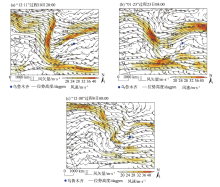
Fig. 1
500 hPa geopotential height field"
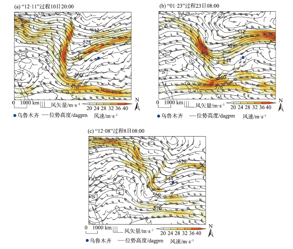

Fig. 2
Time vertical profile of wind field in Urumqi"
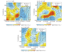
Fig. 3
Time vertical profiles of wind field, potential pseudo-equivalent temperature (θse), and temperature advection in Urumqi"

Tab. 2
Occurrence frequency of wind direction at 850 hPa before snowfall of different magnitudes in Urumqi from 2011 to 2021"
| 850 hPa风向 | 降雪量级 | |||
|---|---|---|---|---|
| 中雪 | 大雪 | 暴雪 | ||
| 西北 | 频次/次 | 16 | 5 | 0 |
| 概率/% | 76 | 50 | 0 | |
| 东南 | 频次/次 | 5 | 5 | 7 |
| 概率/% | 24 | 50 | 100 | |

Fig. 4
Temperature and humidity profiles before snowstorms in Urumqi"

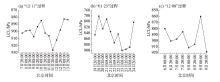
Fig. 5
Lifting condensation level (LCL) before and after snowstorms in Urumqi"
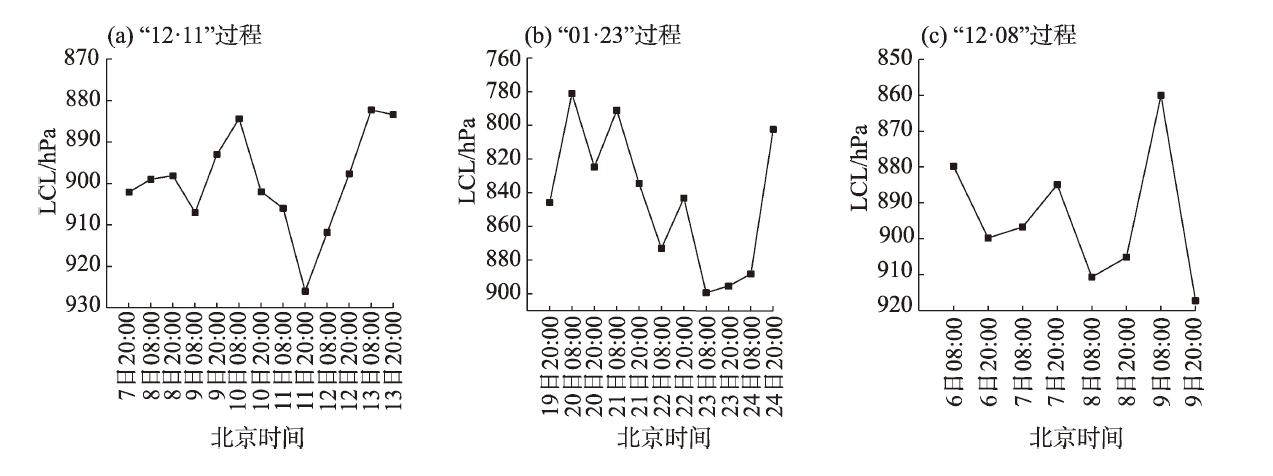

Fig. 6
Time vertical profiles of divergence, vorticity, and vertical velocity in Urumqi"
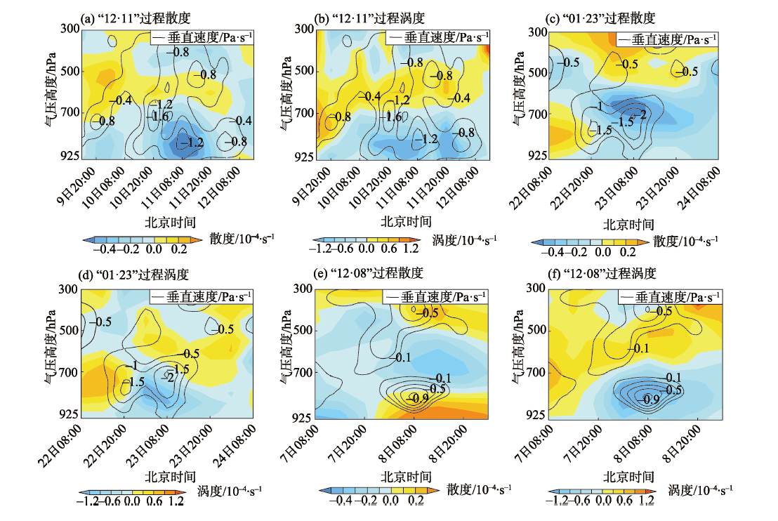

Fig. 7
Time vertical profiles of water vapor flux and water vapor flux divergence in Urumqi"

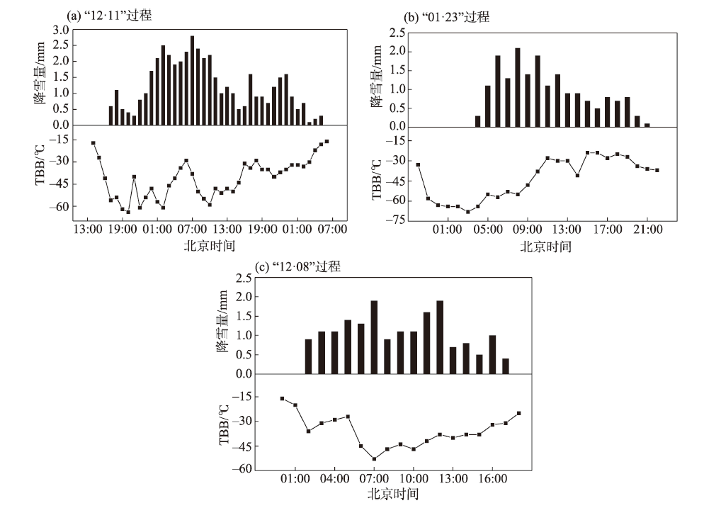
Fig. 8
Hourly snowfall and black body temperature (TBB) changes in Urumqi"
| [1] | 王勇, 赵战成, 晏军, 等. 新疆雪灾的时空分布特征及其等级划分[J]. 干旱区地理, 2020, 43(3): 577-583. |
| [Wang Yong, Zhao Zhancheng, Yan Jun, et al. Spatial and temporal distribution characteristics and its classification of snow disaster in Xinjiang[J]. Arid Land Geography, 2020, 43(3): 577-583. ] | |
| [2] | 阎琦, 温敏, 陆井龙, 等. 两次引发辽宁暴雪过程低涡的动力发展机制[J]. 气象, 2016, 42(4): 406-414. |
| [Yan Qi, Wen Min, Lu Jinglong, et al. Dynamic diagnosis on formation and developing mechanism of two vortices causing snowstorms in Liaoning[J]. Meteorological Monthly, 2016, 42(4): 406-414. ] | |
| [3] | 孙欣, 蔡芗宁, 陈传雷, 等. “070304”东北特大暴雪的分析[J]. 气象, 2011, 37(7): 863-870. |
| [Sun Xin, Cai Xiangning, Chen Chuanlei, et al. Analysis of the 4 March 2007 heavy snowstorm in northeast China[J]. Meteorological Monthly, 2011, 37(7): 863-870. ] | |
| [4] | 刘宁微, 齐琳琳, 韩江文. 北上低涡引发辽宁历史罕见暴雪天气过程的分析[J]. 大气科学, 2009, 33(2): 275-284. |
| [Liu Ningwei, Qi Linlin, Han Jiangwen. The analyses of an unusual snowstorm caused by the northbound vortex over Liaoning Province in China[J]. Atmospheric Science, 2009, 33(2): 275-284. ] | |
| [5] |
陈雪珍, 慕建利, 赵桂香, 等. 华北暴雪过程中的急流特征分析[J]. 高原气象, 2014, 33(4): 1069-1075.
doi: 10.7522/j.issn.1000-0534.2013.00205 |
|
[Chen Xuezhen, Mu Jianli, Zhao Guixiang, et al. Analysis of jet stream characteristic during the snowstorm process in north China[J]. Plateau Meteorology, 2014, 33(4): 1069-1075. ]
doi: 10.7522/j.issn.1000-0534.2013.00205 |
|
| [6] | 杨晓亮, 王咏青, 杨敏, 等. 一次暴雨与特大暴雪并存的华北强降水过程分析[J]. 气象, 2014, 40(12): 1446-1454. |
| [Yang Xiaoliang, Wang Yongqing, Yang Min, et al. Analysis on severe heavy precipitation event with rainstorm and large blizzard in north China[J]. Meteorological Monthly, 2014, 40(12): 1446-1454. ] | |
| [7] |
周晋红, 马鸿青, 孙少雄, 等. 山西一次低空偏东风暴雪天气结构特征分析[J]. 高原气象, 2014, 33(5): 1305-1314.
doi: 10.7522/j.issn.1000-0534.2013.00087 |
|
[Zhou Jinhong, Ma Hongqing, Sun Shaoxiong, et al. Structure analysis of a snowstorm with low-level eastern wind in Shanxi Province[J]. Plateau Meteorology, 2014, 33(5): 1305-1314. ]
doi: 10.7522/j.issn.1000-0534.2013.00087 |
|
| [8] | 陈小婷, 潘留杰, 井宇, 等. 陕西东南部一次伴有雷暴的暴雪天气分析[J]. 沙漠与绿洲气象, 2020, 14(4): 1-9. |
| [Chen Xiaoting, Pan Liujie, Jing Yu, et al. Analysis on a snowstorm weather process with thunderstorm in southeast Shaanxi[J]. Desert and Oasis Meteorology, 2020, 14(4): 1-9. ] | |
| [9] | 冀兰芝, 全志伟, 宋琳琳, 等. 甘肃东部一次暴雪过程的诊断分析和数值模拟[J]. 干旱气象, 2014, 32(5): 845-850. |
| [Ji Lanzhi, Quan Zhiwei, Song Linlin, et al. Numerical simulation and analysis of a snowstorm event in east Gansu Province[J]. Journal of Arid Meteorology, 2014, 32(5): 845-850. ] | |
| [10] | 杨涛, 杨莲梅, 周鸿奎, 等. 新疆北部小时降雪特征及大暴雪天气影响系统研究[J]. 干旱区地理, 2022, 45(3): 725-733. |
| [Yang Tao, Yang Lianmei, Zhou Hongkui, et al. Hourly snowfall characteristics and influence system of heavy snowstorm in northern Xinjiang[J]. Arid Land Geography, 2022, 45(3): 725-733. ] | |
| [11] |
杨霞, 李阿桥, 赵逸舟, 等. 1961—2018年新疆北部冬季暴雪时空分布及其环流特征[J]. 冰川冻土, 2020, 42(3): 756-765.
doi: 10.7522/j.issn.1000-0240.2020.0060 |
|
[Yang Xia, Li Aqiao, Zhao Yizhou, et al. Spatial-temporal distribution and general circulation of snowstorm in northern Xinjiang from 1961 to 2018[J]. Journal of Glaciology and Geocryology, 2020, 42(3): 756-765. ]
doi: 10.7522/j.issn.1000-0240.2020.0060 |
|
| [12] |
刘晶, 李娜, 陈春艳. 新疆北部一次暖区暴雪过程锋面结构及中尺度云团分析[J]. 高原气象, 2018, 37(1): 158-166.
doi: 10.7522/j.issn.1000-0534.2017.00008 |
|
[Liu Jing, Li Na, Chen Chunyan. The frontal structure and analysis on mesoscale cloud characteristic during a warm zone blizzard process in north Xinjiang[J]. Plateau Meteorology, 2018, 37(1): 158-166. ]
doi: 10.7522/j.issn.1000-0534.2017.00008 |
|
| [13] |
杨莲梅, 刘雯. 新疆北部持续性暴雪过程成因分析[J]. 高原气象, 2016, 35(2): 507-519.
doi: 10.7522/j.issn.1000-0534.2014.00161 |
|
[Yang Lianmei, Liu Wen. Cause analysis of persistent heavy snow processes in the northern Xinjiang[J]. Plateau Meteorology, 2016, 35(2): 507-519. ]
doi: 10.7522/j.issn.1000-0534.2014.00161 |
|
| [14] | 庄晓翠, 覃家秀, 李博渊. 2014年新疆西部一次暴雪天气的中尺度特征[J]. 干旱气象, 2016, 34(2): 326-334. |
| [Zhuang Xiaocui, Qin Jiaxiu, Li Boyuan. Mesoscale characteristic of a snowstorm in western Xinjiang in 2014[J]. Journal of Arid Meteorology, 2016, 34(2): 326-334. ] | |
| [15] | 张俊兰, 施俊杰, 李伟, 等. 乌鲁木齐暴雪天气的环流配置及中尺度系统特征[J]. 沙漠与绿洲气象, 2021, 15(1): 1-8. |
| [Zhang Junlan, Shi Junjie, Li Wei, et al. Atmospheric circulation and meso-scale system characteristics of snowstorm in Urumqi[J]. Desert and Oasis Meteorology, 2021, 15(1): 1-8. ] | |
| [16] | 庄晓翠, 李健丽, 李博渊, 等. 天山北坡2次暴雪过程机理分析[J]. 沙漠与绿洲气象, 2019, 13(1): 29-38. |
| [Zhuang Xiaocui, Li Jianli, Li Boyuan, et al. The mechanism analysis of two times blizzard in central of north slope of Tianshan Mountains[J]. Desert and Oasis Meteorology, 2019, 13(1): 29-38. ] | |
| [17] | 许婷婷, 张云惠, 于碧馨, 等. 2015年12月乌鲁木齐极端暴雪成因分析[J]. 沙漠与绿洲气象, 2017, 11(5): 23-29. |
| [Xu Tingting, Zhang Yunhui, Yu Bixin, et al. Analysis of extreme blizzard in December 2015 in Urumqi[J]. Desert and Oasis Meteorology, 2017, 11(5): 23-29. ] | |
| [18] | 于碧馨, 洪月, 张云惠, 等. 天山两麓一次极端暴雪天气多尺度配置及机制分析[J]. 沙漠与绿洲气象, 2020, 14(5): 11-18. |
| [Yu Bixin, Hong Yue, Zhang Yunhui, et al. Multiscale configuration characteristics and mechanism of an extreme snowstorm over the astride of Tianshan Mountains[J]. Desert and Oasis Meteorology, 2020, 14(5): 11-18. ] | |
| [19] | 李娜, 李如琦, 秦贺, 等. 2018年10月乌鲁木齐暴雪过程锋面分析[J]. 沙漠与绿洲气象, 2020, 14(5): 36-43. |
| [Li Na, Li Ruqi, Qin He, et al. Frontal characteristics of snowstorm process in Urumqi in October 2018[J]. Desert and Oasis Meteorology, 2020, 14(5): 36-43. ] | |
| [20] |
张俊兰, 崔彩霞, 陈春艳. 2013年北疆典型暴雪天气的水汽特征研究[J]. 高原气象, 2013, 32(4): 1115-1125.
doi: 10.7522/j.issn.1000-0534.2012.00105 |
|
[Zhang Junlan, Cui Caixia, Chen Chunyan. Study on water vapor characteristic of heavy snowstorm cause in northern Xinjiang[J]. Plateau Meteorology, 2013, 32(4): 1115-1125. ]
doi: 10.7522/j.issn.1000-0534.2012.00105 |
|
| [21] |
李如琦, 唐冶, 肉孜·阿基. 2010年新疆北部暴雪异常的环流和水汽特征分析[J]. 高原气象, 2015, 34(1): 155-162.
doi: 10.7522/j.issn.1000-0534.2013.00163 |
|
[Li Ruqi, Tang Ye, Aji Rouzi. Atmospheric circulation and water vapor characteristics of snowstorm anomalies in northern Xinjiang in 2010[J]. Plateau Meteorology, 2015, 34(1): 155-162. ]
doi: 10.7522/j.issn.1000-0534.2013.00163 |
|
| [22] | 王智敏, 冯婉悦, 李圆圆, 等. FY-2E卫星反演云特性参数产品在乌鲁木齐暴雪天气分析中的应用[J]. 沙漠与绿洲气象, 2020, 14(3): 53-60. |
| [Wang Zhimin, Feng Wanyue, Li Yuanyuan, et al. Microphysical characteristic parameters product retrieved by FY-2E satellite and its application in the Urumqi snowstorm weather analysis[J]. Desert and Oasis Meteorology, 2020, 14(3): 53-60. ] |
| [1] | HONG Chunhua, LI Xiaohu. Assessing the spatial equity of urban educational resources under the background of population changes: A case study of the main urban area of Urumqi City [J]. Arid Land Geography, 2024, 47(8): 1411-1419. |
| [2] | LIN Qiuping, LI Songrui, YANG Shangguang, WANG Yunyun. Spatiotemporal evolution, influencing factors, and development strategies of logistics enterprise location in Urumqi City [J]. Arid Land Geography, 2024, 47(7): 1252-1262. |
| [3] | TANG Yuting, DU Hongru. Spatial scope of community living circle and comprehensive measurement method of construction level: Urumqi City as an example [J]. Arid Land Geography, 2024, 47(2): 332-342. |
| [4] | PENG Ya, WANG Juanjuan, WANG Shanshan, TIAN Liulan, LIU Jie, WU Zhaopeng. Spatiotemporal pattern evolution of land use conflict in Urumqi City from the perspective of ecological security [J]. Arid Land Geography, 2024, 47(1): 81-92. |
| [5] | TIAN Liulan, WANG Shanshan, WU Zhaopeng. Construction of ecological security pattern in Urumqi based on multi-temporal remote sensing data [J]. Arid Land Geography, 2023, 46(7): 1155-1165. |
| [6] | ZHU Lei, LI Yannan, HU Jing, TIAN Xiaobo, XU Jiahui, QING Qi. Multi-scale characteristics and influencing mechanism of spatial pattern on research and practice bases in China [J]. Arid Land Geography, 2023, 46(4): 625-635. |
| [7] | LIANG Liang, GUO Xiaosong, CHEN Hanjie, XU Haofan, ZHOU Yanbo, XIE Shaowen, YANG Fen, WEI Chaoyang. Accumulation characteristics and ecological risks of heavy metals in green land soils in core urban area of Urumqi City [J]. Arid Land Geography, 2023, 46(11): 1868-1878. |
| [8] | SUI Lu, PU Chunling, LIU Zhiyou, BAI Pengfei, LIU Tao. Trade-off synergy of ecosystem service value in Urumqi City based on PLUS model [J]. Arid Land Geography, 2023, 46(1): 159-168. |
| [9] | LI Anbei,WAN Yu,ZHANG Jun,LI Ruqi,Mangsuer AIRETI,LI Na. Circulation classification and cause analysis of the snowstorm case in Urumqi City from 1961 to 2019 [J]. Arid Land Geography, 2022, 45(2): 379-388. |
| [10] | ZHAO Keming,LI Na,LI Xia,SUN Mingjing,SHI Junjie,AN Dawei,PU Jie,ZHENG Bohua. Characteristic analysis of atmospheric diffusion conditions of winter foehn weather process in Urumqi City [J]. Arid Land Geography, 2021, 44(6): 1534-1544. |
| [11] | ZHAO Yongyu,Alimujiang KASIM,GAO Pengwen,LIANG Hongwu. Quantitative analysis of urban expansion and response factors in Urumqi City based on random forest algorithm and geographical detector [J]. Arid Land Geography, 2021, 44(6): 1729-1739. |
| [12] | MIAO Yunling,GONG Hengrui,WANG Jian,GE Yicheng,LI Ruqi. Diurnal variation characteristics of summer precipitation in Urumqi Cityfrom 2012 to 2019 [J]. Arid Land Geography, 2021, 44(5): 1222-1230. |
| [13] | SHI Tiange,SHI Hui. Urban expansion and its temporal and spatial driving forces of Urumqi based on geo-detector method [J]. Arid Land Geography, 2021, 44(3): 867-876. |
| [14] | YANG Xia,ZHAO Yizhou,CAI Mei,ZHANG Chao. Diurnal temperature variation characteristics in the downtown of Urumqi [J]. Arid Land Geography, 2021, 44(2): 360-368. |
| [15] | WANG Yishan,ZHANG Fei,CHEN Rui,QI Yaxiao,LIU Changjiang. Comprehensive ecological security assessment: A case study of Urumqi City [J]. Arid Land Geography, 2021, 44(2): 427-440. |
|
||