Arid Land Geography ›› 2024, Vol. 47 ›› Issue (3): 433-444.doi: 10.12118/j.issn.1000-6060.2023.375
• Biology and Pedology • Previous Articles Next Articles
LIU Ruiliang1( ), JIA Keli1(), LI Xiaoyu1, CHEN Ruihua1, WANG Yijing1, ZHANG Junhua2
Received:2023-07-21
Revised:2023-08-25
Online:2024-03-25
Published:2024-03-29
Contact:
JIA Keli
E-mail:liuruiliang2022@163.com;jiakl@nxu.edu.cn
LIU Ruiliang, JIA Keli, LI Xiaoyu, CHEN Ruihua, WANG Yijing, ZHANG Junhua. Inversion of soil salt content by combining optical and microwave remote sensing in cultivated land[J].Arid Land Geography, 2024, 47(3): 433-444.
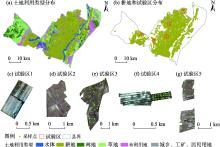
Fig. 1
Land use types of the study area and distribution of the test areas"

Tab. 1
Descriptive statistics of soil samples"
| 样本等级(含盐量/g·kg-1) | 样本数量/个 | 含盐量/g·kg-1 | 变异系数/% | ||
|---|---|---|---|---|---|
| 平均值 | 最大值 | 最小值 | |||
| 非盐渍化(<1) | 15 | 0.775 | 0.999 | 0.510 | 16.712 |
| 轻度盐渍化(1~2) | 27 | 1.326 | 1.963 | 1.008 | 19.913 |
| 中度盐渍化(2~4) | 32 | 2.853 | 3.795 | 2.066 | 18.081 |
| 重度盐渍化(4~6) | 15 | 4.966 | 5.909 | 4.060 | 12.385 |
| 盐土(>6) | 15 | 8.208 | 14.231 | 6.145 | 25.133 |
| 总样本 | 104 | 3.251 | 14.231 | 0.510 | 79.154 |
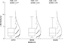
Fig. 2
Distributions of soil samples in different datasets"
Tab. 2
Calculation formulas of spectral indices"
| 光谱指数 | 公式 |
|---|---|
| 盐分指数(SI)[ | |
| 盐分指数1(SI1)[ | |
| 盐渍化指数1(S1)[ | Blue/Red |
| 盐渍化指数2(S2)[ | (Blue-Red)/(Blue+Red) |
| 盐渍化指数5(S5)[ | Blue×Red/Green |
| 扩展差值植被指数(EDVI)[ | NIR+SWIR1-Red |
| 扩展比值植被指数(ERVI)[ | (NIR+SWIR1)/Green |
| 大气阻抗植被指数 (ARVI)[ | (NIR-2Red+Blue)/(NIR+2Red-Blue) |
| 冠层盐度响应植被指数 (CRSI)[ | |
| 扩展增强型植被指数 (EEVI)[ |
Tab. 3
Calculation formulas of radar polarization combination indices"
| 雷达极化组合指数 | 参考文献 | 雷达极化组合指数 | 参考文献 |
|---|---|---|---|
| VV | [ | VV2-VH2 | [ |
| VH | [ | VV2+VH | [ |
| VV-VH | [ | VV2-VH | [ |
| VV+VH | [ | VH2-VV | [ |
| VV2+VH2 | [ | VH2-VV2 | [ |

Fig. 3
Research route"


Fig. 4
Projection importance between soil salt content and characteristic variables"
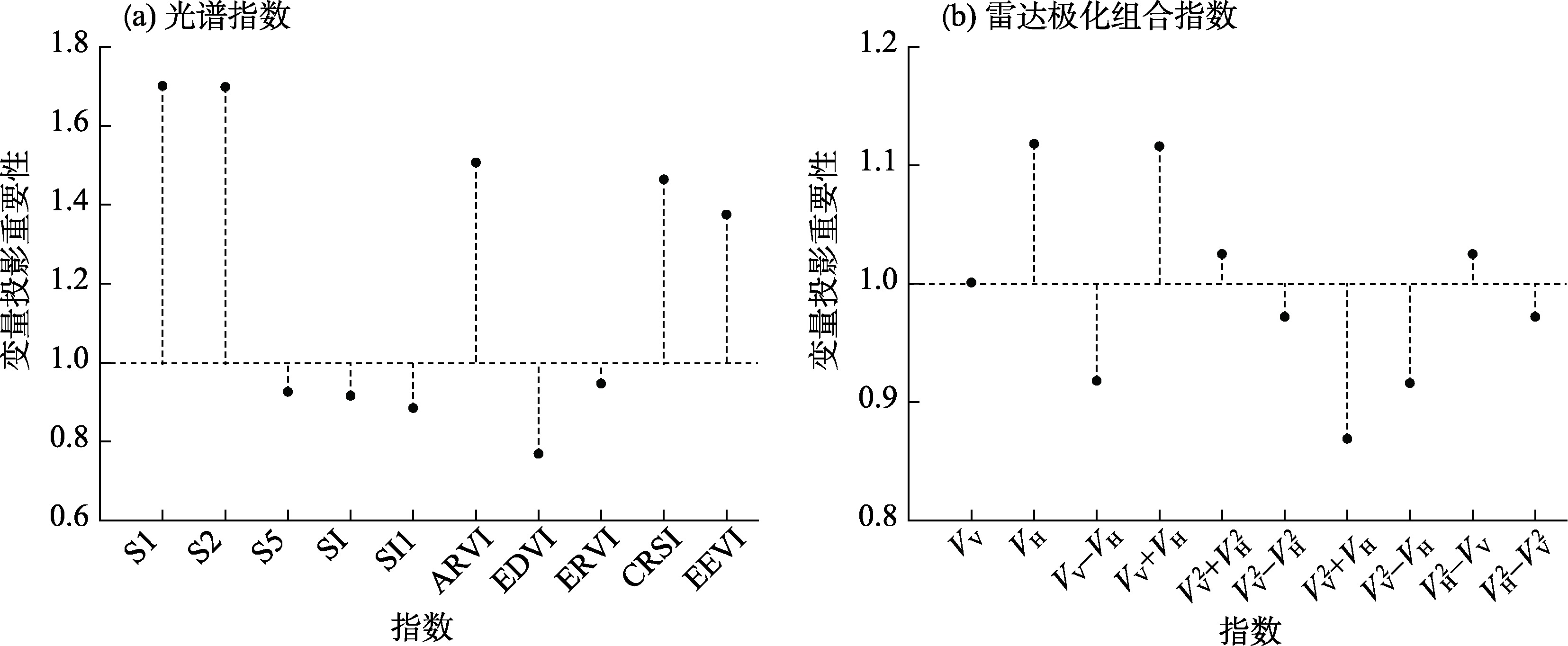
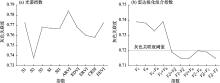
Fig. 5
Grey relativity between soil salt content and characteristic variables"

Tab. 4
Machine learning models based on single remote sensing data"
| 变量 | 模型类别 | 建模集 | 验证集 | |||
|---|---|---|---|---|---|---|
| R2 | RMSE | R2 | RMSE | |||
| 光谱指数 | VIP-BPNN | 0.325 | 1.828 | 0.464 | 1.926 | |
| VIP-SVM | 0.552 | 1.487 | 0.476 | 1.840 | ||
| VIP-RF | 0.726 | 1.163 | 0.689 | 1.307 | ||
| GC-BPNN | 0.328 | 1.822 | 0.433 | 1.979 | ||
| GC-SVM | 0.488 | 1.591 | 0.461 | 1.904 | ||
| GC-RF | 0.649 | 1.317 | 0.327 | 2.158 | ||
| 雷达极化组合指数 | VIP-BPNN | 0.228 | 1.954 | 0.291 | 2.214 | |
| VIP-SVM | 0.482 | 1.475 | 0.524 | 1.814 | ||
| VIP-RF | 0.706 | 1.205 | 0.543 | 1.509 | ||
| GC-BPNN | 0.220 | 1.964 | 0.346 | 2.127 | ||
| GC-SVM | 0.509 | 1.440 | 0.356 | 1.910 | ||
| GC-RF | 0.518 | 1.543 | 0.413 | 2.015 | ||
Tab. 5
Machine learning models based on multi-source remote sensing data"
| 变量 | 模型类别 | 建模集 | 验证集 | |||
|---|---|---|---|---|---|---|
| R2 | RMSE | R2 | RMSE | |||
| 光谱指数和雷达极化组合指数 | VIP-BPNN | 0.694 | 1.230 | 0.588 | 1.689 | |
| VIP-SVM | 0.787 | 1.027 | 0.643 | 1.572 | ||
| VIP-RF | 0.791 | 1.016 | 0.780 | 1.132 | ||

Fig. 6
VIP-RF models of different data source variables"
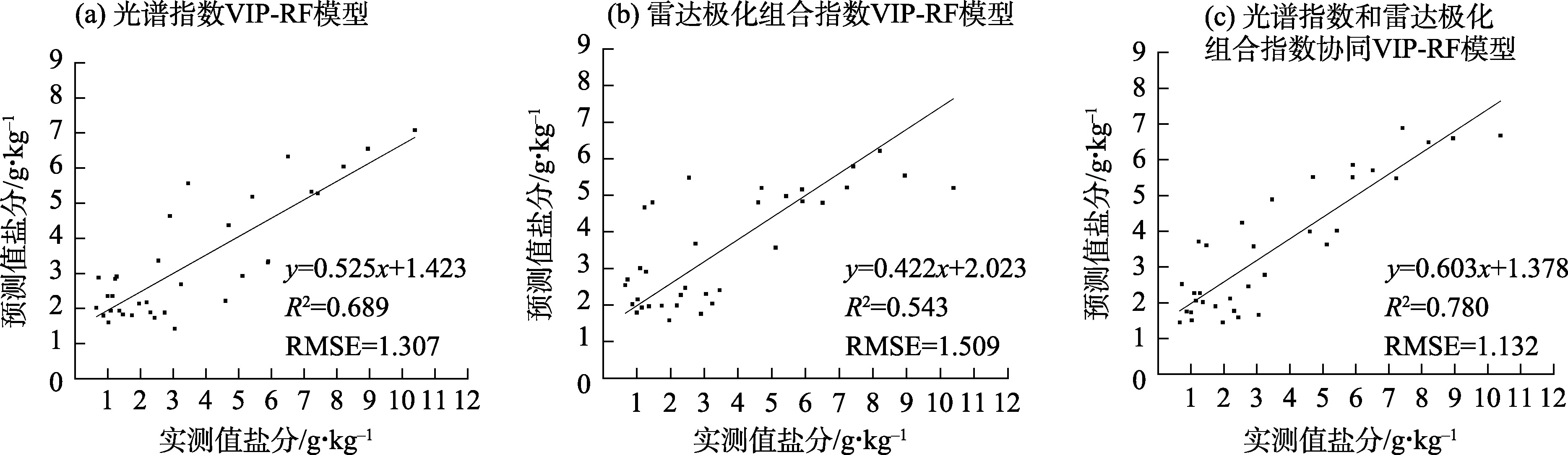
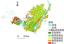
Fig. 7
Grade distribution of soil salinity inversion in cultivated land"

Tab. 6
Grade statistics of soil salinity inversion in cultivated land"
| 盐渍化程度 | 非盐渍化 | 轻度盐渍化 | 中度盐渍化 | 重度盐渍化 | 盐土 |
|---|---|---|---|---|---|
| 像元数/个 | 138897 | 250353 | 353408 | 161882 | 148863 |
| 面积/km2 | 124.95 | 225.18 | 317.73 | 145.60 | 133.86 |
| 占比% | 13.19 | 23.77 | 33.54 | 15.37 | 14.13 |
| [1] | Abdelaziz M E, Abdelsattar M, Abdeldaym E A, et al. Piriformospora indica alters Na+/K+ homeostasis, antioxidant enzymes and LeNHX1 expression of greenhouse tomato grown under salt stress[J]. Scientia Horticulturae, 2019, 256: 108532, doi: 10.1016/j.scienta.2019.05.059. |
| [2] |
Singh A. Soil salinity: A global threat to sustainable development[J]. Soil Use and Management, 2022, 38(1): 39-67.
doi: 10.1111/sum.v38.1 |
| [3] | 李星佑, 张飞, 王筝. 土壤盐渍化遥感监测模型构建方法现状与发展趋势[J]. 自然资源遥感, 2022, 34(4): 11-21. |
| [Li Xingyou, Zhang Fei, Wang Zheng. Present situation and development trend in building remote sensing monitoring models of soil salinization[J]. Remote Sensing for Natural Resources, 2022, 34(4): 11-21.] | |
| [4] | 陈红艳, 赵庚星, 陈敬春, 等. 基于改进植被指数的黄河口区盐渍土盐分遥感反演[J]. 农业工程学报, 2015, 31(5): 107-114. |
| [Chen Hongyan, Zhao Gengxing, Chen Jingchun, et al. Remote sensing inversion of saline soil salinity based on modified vegetation index in estuary area of Yellow River[J]. Transactions of the Chinese Society of Agricultural Engineering, 2015, 31(5): 107-114.] | |
| [5] |
Wang J Z, Ding J L, Ma X K, et al. Capability of Sentinel-2 MSI data for monitoring and mapping of soil salinity in dry and wet seasons in the Ebinur Lake region, Xinjiang, China[J]. Geoderma, 2019, 353: 172-187.
doi: 10.1016/j.geoderma.2019.06.040 |
| [6] | 赵孟银. 遥感影像去云方法研究[D]. 天津: 天津科技大学, 2016. |
| [Zhao Mengyin. Study of clouds removal methods on remote sensing images[D]. Tianjin: Tianjin University of Science and Technology, 2016.] | |
| [7] | 李彪, 王耀强. 土壤盐渍化雷达反演模拟研究[J]. 干旱区资源与环境, 2015, 29(8): 180-184. |
| [Li Biao, Wang Yaoqiang. Radar inversion and simulation of salty soil salinization[J]. Journal of Arid Land Resources and Environment, 2015, 29(8): 180-184.] | |
| [8] | 马驰. 基于Sentinel 1双极化雷达影像的土壤含盐量反演[J]. 农业工程学报, 2018, 34(2):153-158. |
| [Ma Chi. Quantitative retrieval of soil salt content based on Sentinel-1 dual polarization radar image[J]. Transactions of the Chinese Society of Agricultural Engineering, 2018, 34(2): 153-158.] | |
| [9] | 张智韬, 杜瑜燕, 劳聪聪, 等. 基于雷达遥感的不同深度土壤含盐量反演模型[J]. 农业机械学报, 2020, 51(10): 243-251. |
| [Zhang Zhitao, Du Yuyan, Lao Congcong, et al. Inversion model of soil salt content in different depths based on radar remote sensing[J]. Transactions of the Chinese Society for Agricultural Machinery, 2020, 51(10): 243-251.] | |
| [10] | 肖森天, 依力亚斯江·努尔麦麦提, 努尔比耶·穆合塔尔, 等. 基于光学和雷达多源遥感的于田绿洲土壤盐渍化时空分析[J]. 干旱区研究, 2023, 40(1): 59-68. |
| [Xiao Sentian, Nurmemet Ilyas, Muhetaer Nuerbiye, et al. Spatial and temporal analysis of soil salinity in Yutian Oasis by combined optical and radar multi-source remote sensing[J]. Arid Zone Research, 2023, 40(1): 59-68.] | |
| [11] | 王飞, 丁建丽, 魏阳, 等. 基于Landsat系列数据的盐分指数和植被指数对土壤盐度变异性的响应分析——以新疆天山南北典型绿洲为例[J]. 生态学报, 2017, 37(15): 5007-5022. |
| [Wang Fei, Ding Jianli, Wei Yang, et al. Sensitivity analysis of soil salinity and vegetation indices to detect soil salinity variation by using Landsat series images: Applications in different oases in Xinjiang, China[J]. Acta Ecologica Sinica, 2017, 37(15): 5007-5022.] | |
| [12] | 王海峰. 基于高光谱遥感的土壤水盐监测模型研究[D]. 咸阳: 西北农林科技大学, 2019. |
| [Wang Haifeng. Hyperspectral remote sensing based models for soil moisture and salinity prediction[D]. Xianyang: Northwest A & F University, 2019.] | |
| [13] | 刘恩, 王军涛, 常步辉, 等. 小开河引黄灌区土壤盐渍化定量遥感反演[J]. 中国农村水利水电, 2019(12): 20-24. |
| [Liu En, Wang Juntao, Chang Buhui, et al. Quantitative remote sensing inversion of soil salinization in Xiaokaihe Yellow River irrigation district[J]. China Rural and Hydropower, 2019(12): 20-24.] | |
| [14] | 刘亚秋. 黄河三角洲盐渍土盐分及组分定量光谱估测研究[D]. 泰安: 山东农业大学, 2017. |
| [Liu Yaqiu. Quantitative estimation of soil salinity and its composition based on spectra in Yellow River Delta[D]. Tai'an: Shandong Agricultural University, 2017.] | |
| [15] | 曹肖奕, 丁建丽, 葛翔宇, 等. 基于不同卫星光谱模拟的土壤电导率估算研究[J]. 干旱区地理, 2020, 43(1): 172-181. |
| [Cao Xiaoyi, Ding Jianli, Ge Xiangyu, et al. Estimation of soil conductivity based on spectral simulation of different satellites[J]. Arid Land Geography, 2020, 43(1): 172-181.] | |
| [16] | 魏慧敏, 贾科利, 张旭, 等. 基于机器学习和多光谱遥感的银川平原土壤盐分预测[J]. 干旱区地理, 2023, 46(1): 103-114. |
| [Wei Huimin, Jia Keli, Zhang Xu, et al. Prediction of soil salinity based on machine learning and multispectral remote sensing in Yinchuan Plain[J]. Arid Land Geography, 2023, 46(1): 103-114.] | |
| [17] | 李小雨, 贾科利, 魏慧敏, 等. 基于随机森林算法的土壤含盐量预测[J]. 干旱区研究, 2023, 40(8): 1258-1267. |
| [Li Xiaoyu, Jia Keli, Wei Huimin, et al. Prediction of soil salt content based on random forest algorithm[J]. Arid Zone Research, 2023, 40(8): 1258-1267.] | |
| [18] |
Khan N M, Rastoskuev V V, Sato Y, et al. Assessment of hydrosaline land degradation by using a simple approach of remote sensing indicators[J]. Agricultural Water Management, 2005, 77(1-3): 96-109.
doi: 10.1016/j.agwat.2004.09.038 |
| [19] | 樊彦国, 张维康, 刘敬一. 基于植被指数-盐分指数特征空间的黄河三角洲盐渍化遥感监测研究[J]. 山东农业科学, 2016, 48(5): 137-141. |
| [Fan Yanguo, Zhang Weikang, Liu Jingyi. Remote sensing monitoring model of soil salinization in the Yellow River Delta zone based on vegetation index-salt index feature space[J]. Shandong Agricultural Sciences, 2016, 48(5): 137-141.] | |
| [20] | Sahana M, Rehman S, Patel P P, et al. Assessing the degree of soil salinity in the Indian Sundarban Biosphere Reserve using measured soil electrical conductivity and remote sensing data-derived salinity indices[J]. Arabian Journal of Geosciences, 2020, 13(24): 1289, doi: 10.1007/s12517-020-06310-w. |
| [21] |
Nguyen K A, Liou Y A, Tran H P, et al. Soil salinity assessment by using near-infrared channel and vegetation soil salinity index derived from Landsat 8 OLI data: A case study in the Tra Vinh Province, Mekong Delta, Vietnam[J]. Progress in Earth and Planetary Science, 2020, 7(1): 1-16.
doi: 10.1186/s40645-019-0311-0 |
| [22] | 孙亚楠, 李仙岳, 史海滨, 等. 基于多源数据融合的盐分遥感反演与季节差异性研究[J]. 农业机械学报, 2020, 51(6): 169-180. |
| [Sun Ya’nan, Li Xianyue, Shi Haibin, et al. Remote sensing inversion of soil salinity and seasonal difference analysis based on multi-source data fusion[J]. Transactions of the Chinese Society for Agricultural Machinery, 2020, 51(6): 169-180.] | |
| [23] |
Brunner P, Li H T, Kinzelbach W, et al. Generating soil electrical conductivity maps at regional level by integrating measurements on the ground and remote sensing data[J]. International Journal of Remote Sensing, 2007, 28(15-16): 3341-3361.
doi: 10.1080/01431160600928641 |
| [24] | 何宝忠, 丁建丽, 刘博华, 等. 渭库绿洲土壤盐渍化时空变化特征[J]. 林业科学, 2019, 55(9): 185-196. |
| [He Baozhong, Ding Jianli, Liu Bohua, et al. Spatiotemporal variation of soil salinization in Weigan-Kuqa River delta oasis[J]. Scientia Silvae Sinicae, 2019, 55(9): 185-196.] | |
| [25] | 郭晓静. 内蒙古河套灌区冻融期土壤盐分的多极化雷达响应分析[D]. 呼和浩特: 内蒙古农业大学, 2014. |
| [Guo Xiaojing. Response analysis of multi-polarization radar on freeze-thaw period soil salt in Inner Mongolia Hetao irrigation district[D]. Hohhot: Inner Mongolia Agricultural University, 2014.] | |
| [26] | 于海云, 王志军, 李彪, 等. 内蒙古河套灌区融解期土壤盐分多极化雷达响应分析[J]. 长江科学院院报, 2015, 32(11): 19-24. |
| [Yu Haiyun, Wang Zhijun, Li Biao, et al. Response analysis of multi-polarization radar on soil salt during melting period in Hetao irrigation district of Inner Mongolia[J]. Journal of Yangtze River Scientific Research Institute, 2015, 32(11): 19-24.] | |
| [27] | 李生勇, 霍轶珍, 王海霞. 内蒙古自治区河套灌区冻结期土壤盐分的多极化雷达响应分析[J]. 江苏农业科学, 2016, 44(3): 348-352. |
| [Li Shengyong, Huo Yizhen, Wang Haixia. Response analysis of multi-polarization radaron soil salinity during freezing period in Hetao irrigation district of Inner Mongolia Autonomous Region[J]. Jiangsu Agricultural Sciences, 2016, 44(3): 348-352.] | |
| [28] |
Oussama A, Elabadi F, Platikanov S, et al. Detection of olive oil adulteration using FT-IR spectroscopy and PLS with variable importance of projection (VIP) scores[J]. Journal of the American Oil Chemists Society, 2012, 89(10): 1807-1812.
doi: 10.1007/s11746-012-2091-1 |
| [29] | Maimaitiyiming M, Ghulam A, Bozzolo A, et al. Early detection of plant physiological responses to different levels of water stress using reflectance spectroscopy[J]. Remote Sensing, 2017, 9(7): 745, doi: 10.3390/rs9070745. |
| [30] |
刘思峰, 蔡华, 杨英杰, 等. 灰色关联分析模型研究进展[J]. 系统工程理论与实践, 2013, 33(8): 2041-2046.
doi: 10.12011/1000-6788(2013)8-2041 |
| [Liu Sifeng, Cai Hua, Yang Yingjie, et al. Advance in grey incidence analysis modelling[J]. Systems Engineering-Theory and Practice, 2013, 33(8): 2041-2046.] | |
| [31] |
杨淑娥, 黄礼. 基于BP神经网络的上市公司财务预警模型[J]. 系统工程理论与实践, 2005, 25(1): 12-18.
doi: 10.12011/1000-6788(2005)1-12 |
| [Yang Shu'e, Huang Li. Financial crisis warning model based on BP neural network[J]. Systems Engineering-Theory & Practice, 2005, 25(1): 12-18.] | |
| [32] | 赵亚琴. 基于模糊神经网络的火灾识别算法[J]. 计算机仿真, 2015, 32(2): 369-373. |
| [Zhao Yaqin. Forest fire recognition algorithm based on fuzzy neural network[J]. Computer Simulation, 2015, 32(2): 369-373.] | |
| [33] | 汪海燕, 黎建辉, 杨风雷. 支持向量机理论及算法研究综述[J]. 计算机应用研究, 2014, 31(5): 1281-1286. |
| [Wang Haiyan, Li Jianhui, Yang Fenglei. Overview of support vector machine analysis and algorithm[J]. Application Research of Computers, 2014, 31(5): 1281-1286.] | |
| [34] |
Biau G, Scornet E. A random forest guided tour[J]. Test, 2016, 25(2): 197-227.
doi: 10.1007/s11749-016-0481-7 |
| [35] |
杨练兵, 陈春波, 郑宏伟, 等. 基于优化随机森林回归模型的土壤盐渍化反演[J]. 地球信息科学学报, 2021, 23(9): 1662-1674.
doi: 10.12082/dqxxkx.2021.200711 |
| [Yang Lianbing, Chen Chunbo, Zheng Hongwei, et al. Retrieval of soil salinity content based on optimized random forest regression model[J]. Journal of Geo-information Science, 2021, 23(9): 1662-1674.] | |
| [36] | 余祥伟, 薛东剑. 星载SAR与OLI影像融合方法研究及质量评价[J]. 西华师范大学学报(自然科学版), 2020, 41(1): 98-103. |
| [Yu Xiangwei, Xue Dongjian. Research and quality evaluation of spaceborne SAR and OLI image fusion methods[J]. Journal of China West Normal University (Natural Sciences Edition), 2020, 41(1): 98-103.] | |
| [37] | 姜红, 玉素甫江·如素力, 拜合提尼沙·阿不都克日木, 等. 基于支持向量机回归算法的土壤水分光学与微波遥感协同反演[J]. 地理与地理信息科学, 2017, 33(6): 30-36. |
| [Jiang Hong, Rusuli Yusufujiang, Abudoukerimu Baihetinisha, et al. Soil moisture retrieval by synergizing optical and microwave remote sensing data based on support vector machine regression algorithm[J]. Geography and Geo-information Science, 2017, 33(6): 30-36.] | |
| [38] | 李明亮. 土壤有机质高光谱灰色关联度估测模型研究[D]. 泰安: 山东农业大学, 2017. |
| [Li Mingliang. Study on the grey relation degree estimation on model of soil organic matter based on hyperspectral[D]. Tai'an: Shandong Agricultural University, 2017.] | |
| [39] |
Viscarra Roseel R A, Webster R. Predicting soil properties from the Australian soil visible-near infrared spectroscopic database[J]. European Journal of Soil Science, 2012, 63(6): 848-860.
doi: 10.1111/ejs.2012.63.issue-6 |
| [40] | 张智韬, 魏广飞, 姚志华, 等. 基于无人机多光谱遥感的土壤含盐量反演模型研究[J]. 农业机械学报, 2019, 50(12): 151-160. |
| [Zhang Zhitao, Wei Guangfei, Yao Zhihua, et al. Soil salt inversion model based on UAV multispectral remote sensing[J]. Transactions of the Chinese Society for Agricultural Machinery, 2019, 50(12): 151-160.] | |
| [41] |
Chen B L, Zheng H W, Luo G P, et al. Adaptive estimation of multi-regional soil salinization using extreme gradient boosting with Bayesian TPE optimization[J]. International Journal of Remote Sensing, 2022, 43(3): 778-811.
doi: 10.1080/01431161.2021.2009589 |
| [42] | Wang L Y, Hu P, Zheng H W, et al. Integrative modeling of heterogeneous soil salinity using sparse ground samples and remote sensing images[J]. Geoderma, 2023, 430: 116321, doi: 10.1016/j.geoderma.2022.116321. |
| [43] |
Xu H T, Chen C B, Zheng H W, et al. AGA-SVR-based selection of feature subsets and optimization of parameter in regional soil salinization monitoring[J]. International Journal of Remote Sensing, 2020, 41(12): 4470-4495.
doi: 10.1080/01431161.2020.1718239 |
| [44] | 张旭. 银川平原土壤盐分空间分布及驱动因子研究[D]. 银川: 宁夏大学, 2022. |
| [Zhang Xu. Study on spatial distribution and driving factors of soil salinity in Yinchuan Plain[D]. Yinchuan: Ningxia University, 2022.] | |
| [45] | 杨劲松, 姚荣江, 王相平, 等. 中国盐渍土研究: 历程, 现状与展望[J]. 土壤学报, 2022, 59(1): 10-27. |
| [Yang Jinsong, Yao Rongjiang, Wang Xiangping, et al. Research on salt-affected soils in China: History, status quo and prospect[J]. Acta Pedologica Sinica, 2022, 59(1): 10-27.] |
|
||