- May. 12, 2025
Arid Land Geography ›› 2023, Vol. 46 ›› Issue (3): 385-396.doi: 10.12118/j.issn.1000-6060.2022.357
• Earth Surface Process • Previous Articles Next Articles
JIANG Leipeng1,2,3( ),DING Jianli1,2,3(),BAO Qingling1,2,3,GE Xiangyu1,2,3,LIU Jingming1,2,3,WANG Jinjie1,2,3
Received:2022-07-15
Revised:2022-09-28
Online:2023-03-25
Published:2023-03-31
Contact:
Jianli DING
E-mail:1786032533@qq.com;watarid@xju.edu.cn
JIANG Leipeng,DING Jianli,BAO Qingling,GE Xiangyu,LIU Jingming,WANG Jinjie. Runoff estimation with low altitude remote sensing and satellite images[J].Arid Land Geography, 2023, 46(3): 385-396.
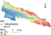
Fig. 1
Distribution of water system of Kashi River in Nilka section"


Fig. 2
Hydraulic geometry flow over inversion flow chart"

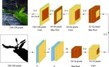
Fig. 3
Flow chart of Keras convolutional neural network"


Fig. 4
Runoff-water level relationship curve of Zhongfengchang hydrological station"
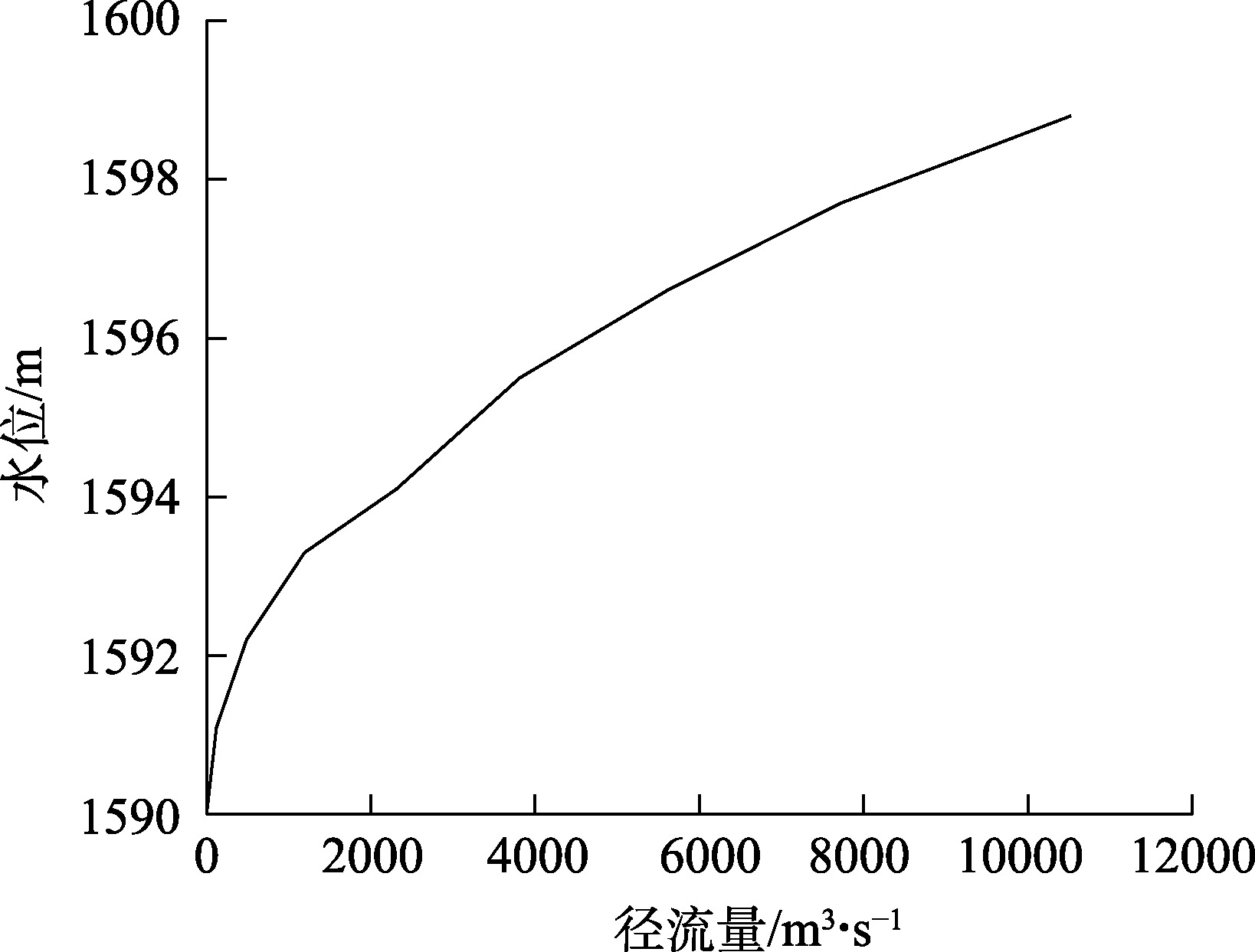

Fig. 5
Relationship curve between river cross-section and hydraulic characteristics"
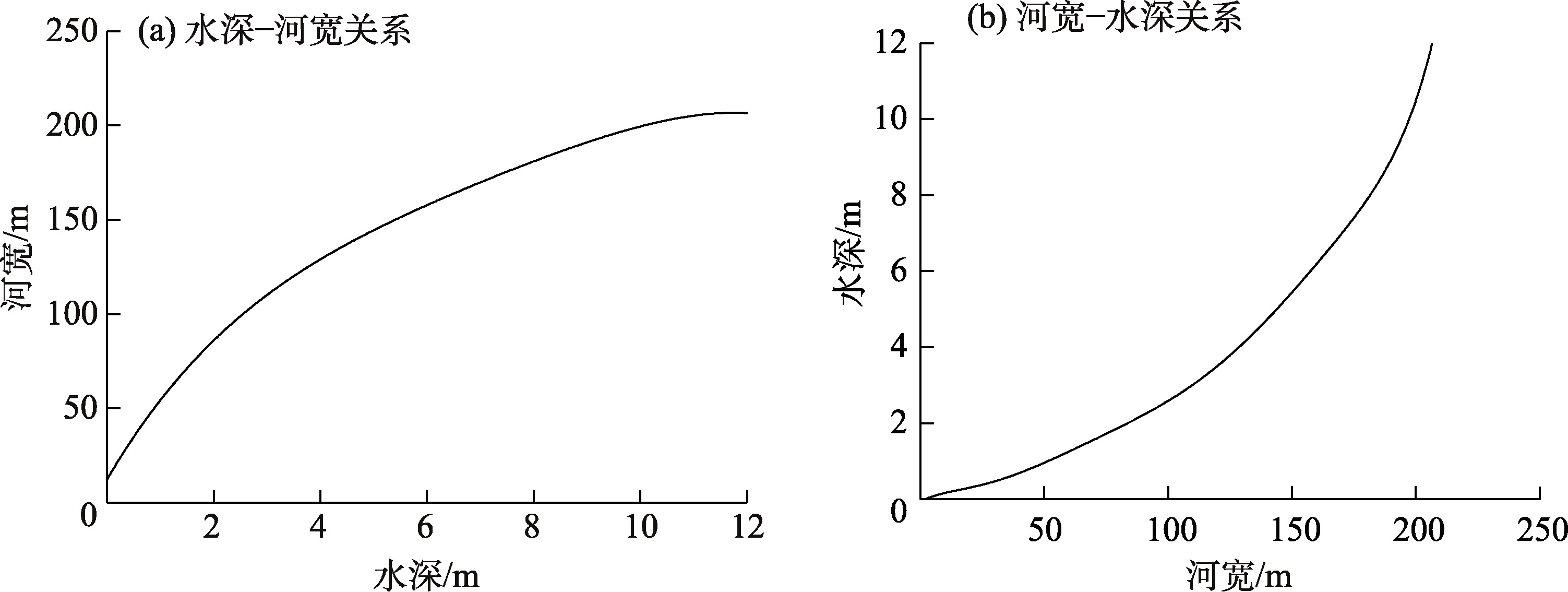
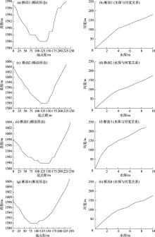
Fig. 6
Fitting hydraulic characteristic curves of four sections at Zhongfengchang river section"

Tab. 1
Morphological characteristic equations and fitting curves of the generalized river section"
| 函数 | H=F(W) | W=G(H) |
|---|---|---|
| 方程 | y=B0+B1x+B2x2+B3x3+B4x4 | y=B0+B1x+B2x2+B3x3+B4x4 |
| 参数值 | B0:37.5882;B1:30.8797 B2:-3.65321;B3:0.36687 B4:-0.0143 | B0:88.38032;B1:3.59985 B2:-0.05631;B3:0.00429 B4:-0.000002 |
| 相关系数 | 0.98 | 0.98 |
| 均方根误差 | 0.56 | 0.50 |
| 残差平方和 | 4.77 | 3.51 |
Tab. 2
Watershed area, generalized width and water depth of the Zhongfengchang cross-section in the Kashi River"
| 日期(年-月-日) | 概化水深/m | 概化河宽/m | 面积/m2 | 日期(年-月-日) | 概化水深/m | 概化河宽/m | 面积/m2 |
|---|---|---|---|---|---|---|---|
| 2016-09-11 | 0.91 | 51.32 | 10264 | 2017-10-03 | 0.81 | 47.27 | 9454 |
| 2016-10-09 | 0.80 | 47.08 | 9416 | 2018-03-08 | 0.71 | 43.34 | 8668 |
| 2016-10-15 | 0.78 | 46.06 | 9212 | 2018-03-18 | 0.73 | 44.03 | 8806 |
| 2017-03-21 | 0.70 | 43.56 | 8712 | 2018-04-17 | 0.79 | 46.80 | 9360 |
| 2017-04-10 | 0.78 | 46.12 | 9224 | 2018-04-25 | 0.84 | 48.80 | 9760 |
| 2017-05-20 | 0.92 | 51.99 | 10398 | 2018-07-19 | 1.78 | 79.83 | 15966 |
| 2017-06-09 | 1.70 | 77.78 | 15556 | 2018-08-18 | 1.83 | 81.24 | 16248 |
| 2017-07-06 | 1.90 | 83.45 | 16690 | 2018-08-28 | 1.74 | 78.75 | 15750 |
| 2017-08-08 | 2.09 | 88.41 | 17682 | 2018-09-04 | 1.75 | 78.78 | 15756 |
| 2017-08-26 | 1.71 | 77.89 | 15578 | 2018-10-07 | 0.75 | 45.30 | 9060 |
| 2017-09-10 | 1.55 | 73.11 | 14622 | 2019-03-23 | 0.73 | 44.16 | 8832 |
| 2017-09-17 | 1.08 | 57.34 | 11468 | 2019-04-05 | 0.72 | 43.83 | 8766 |
Tab. 3
Evaluation results of grading accuracy"
| 方法 | 径流量0~50 m3·s-1 | 径流量50~100 m3·s-1 | |||||
|---|---|---|---|---|---|---|---|
| RA/% | RMSE/m3·s-1 | MPE | RA/% | RMSE/m3·s-1 | MPE | ||
| 式(1) | 4.35 | 7.15 | -0.15 | 4.38 | 2.81 | -0.01 | |
| 式(2) | 42.34 | 19.75 | 0.31 | 16.32 | 10.85 | -0.01 | |
| 式(3) | 19.42 | 8.86 | -0.14 | 8.89 | 5.96 | -0.20 | |
| 方法 | 径流量100~200 m3·s-1 | 径流量>200 m3·s-1 | |||||
| RA/% | RMSE/m3·s-1 | MPE | RA/% | RMSE/m3·s-1 | MPE | ||
| 式(1) | 13.60 | 22.29 | -0.05 | 8.53 | 28.21 | -0.01 | |
| 式(2) | 8.71 | 13.60 | -0.10 | 3.54 | 11.20 | 0.00 | |
| 式(3) | 8.99 | 13.37 | -0.05 | 0.38 | 1.06 | -0.01 | |
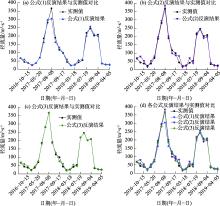
Fig. 7
Runoff inversion results and measured data"

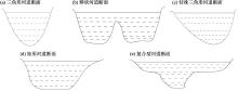
Fig. 8
Different forms of river overflow cross-sections"
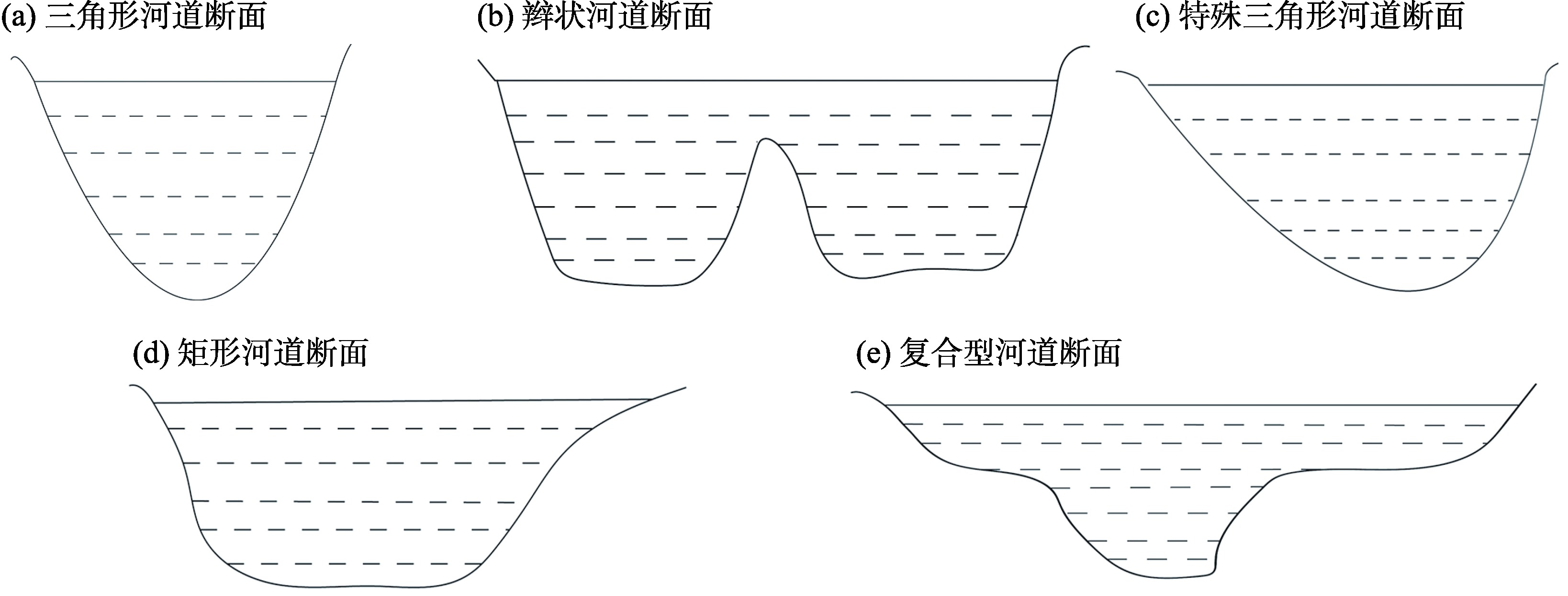

Fig. 9
Underwater section fitting"

| [1] | 王瑾杰, 丁建丽, 张成, 等. 基于SCS模型的新疆博尔塔拉河流域径流模拟[J]. 农业工程学报, 2016, 32(7): 129-135. |
| [ Wang Jinjie, Ding Jianli, Zhang Cheng, et al. Runoff simulation based on SCS mode in Bortala River Basin in Xinjiang[J]. Transactions of the Chinese Society of Agricultural Engineering, 2016, 32(7): 129-135. ] | |
| [2] | 王颖慧, 丁建丽, 李晓航, 等. 伊犁河流域土地利用/覆被变化对生态系统服务价值的影响——基于强度分析模型[J]. 生态学报, 2022, 42(8): 3106-3118. |
| [ Wang Yinghui, Ding Jianli, Li Xiaohang, et al. Impact of LUCC on ecosystem services values in the Yili River Basin based on an intensity analysis model[J]. Acta Ecologica Sinica, 2022, 42(8): 3106-3118. ] | |
| [3] | 王瑾杰, 丁建丽, 张喆, 等. 干旱区降雨、融雪混合补给下的径流模拟研究——以博尔塔拉河上游流域为例[J]. 干旱区地理, 2016, 39(6): 1238-1246. |
| [ Wang Jinjie, Ding Jianli, Zhang Zhe, et al. Simulation of runoff of arid area with rainfall and snowmelt based on GF-1 satellite: A case of Bortala River[J]. Arid Land Geography, 2016, 39(6): 1238-1246. ] | |
| [4] | 魏桢, 贾海峰, 姜其贵, 等. 再生水补水河道中流速对浮游藻类生长影响的模拟实验[J]. 环境工程学报, 2017, 11(12): 6540-6546. |
| [ Wei Zhen, Jia Haifeng, Jiang Qigui, et al. Simulation experiment of phytoplankton growth induced by flow velocity in rivers replenished with reclaimed water[J]. Chinese Journal of Environmental Engineering, 2017, 11(12): 6540-6546. ] | |
| [5] |
Ruiz J, Macías D, Peters F. Turbulence increases the average settling velocity of phytoplankton cells[J]. Proceedings of the National Academy of Sciences, 2004, 101(51): 17720-17724.
doi: 10.1073/pnas.0401539101 |
| [6] | 陈亚宁, 李稚, 方功焕. 中亚天山地区关键水文要素变化与水循环研究进展[J]. 干旱区地理, 2022, 45(1): 1-8. |
| [ Chen Yaning, Li Zhi, Fang Gonghuan. Changes of key hydrological elements and research progress of water cycle in the Tianshan Mountains, Central Asia[J]. Arid Land Geography, 2022, 45(1): 1-8. ] | |
| [7] | 李肖杨, 朱成刚, 马玉其, 等. 新疆孔雀河流域生态基流与天然植被需水量研究[J]. 干旱区地理, 2021, 44(2): 337-345. |
| [ Li Xiaoyang, Zhu Chenggang, Ma Yuqi, et al. Ecological baseflow and natural vegetation water requirement of Konqi River Basin, Xinjiang[J]. Arid Land Geography, 2021, 44(2): 337-345. ] | |
| [8] |
Smith L C, Isacks B L, Forster R R, et al. Estimation of discharge from braided glacial rivers using ERS 1 synthetic aperture radar: First results[J]. Water Resources Research, 1995, 31(5): 1325-1329.
doi: 10.1029/95WR00145 |
| [9] |
Brakenridge G R, Tracy B T, Knox J C. Orbital SAR remote sensing of a river flood wave[J]. International Journal of Remote Sensing, 1998, 19(7): 1439-1445.
doi: 10.1080/014311698215559 |
| [10] |
Pierre B, Monnier J, Garambois P A, et al. On the assimilation of altimetric data in 1D Saint-Venant river flow models[J]. Advances in Water Resources, 2018, 119: 41-59.
doi: 10.1016/j.advwatres.2018.06.004 |
| [11] |
Altenau E H, Pavelsky T M, Moller D, et al. Temporal variations in river water surface elevation and slope captured by AirSWOT[J]. Remote Sensing of Environment, 2019, 224: 304-316.
doi: 10.1016/j.rse.2019.02.002 |
| [12] |
Wufu A, Yang S T, Chen Y, et al. Estimation of long-term river discharge and its changes in ungauged watersheds in Pamir Plateau[J]. Remote Sensing, 2021, 13(20): 4043, doi: 10.3390/rs13204043.
doi: 10.3390/rs13204043 |
| [13] |
Wufu A, Chen Y, Yang S T, et al. Changes in glacial meltwater runoff and its response to climate change in the Tianshan region detected using unmanned aerial vehicles (UAVs) and satellite remote sensing[J]. Water, 2021, 13(13): 1753, doi: 10.3390/w13131753.
doi: 10.3390/w13131753 |
| [14] | Leopold L B, Maddock T. The hydraulic geometry of stream channels and some physiographic implications[M]. Washington: US Government Printing Office, 1953. |
| [15] |
Rhodes D D. The b-f-m diagram: Graphical representation and interpretation of at-a-station hydraulic geometry[J]. American Journal of Science, 1977, 277(1): 73-96.
doi: 10.2475/ajs.277.1.73 |
| [16] |
Gleason C J, Smith L C. Toward global mapping of river discharge using satellite images and at-many-stations hydraulic geometry[J]. Proceedings of the National Academy of Sciences, 2014, 111(13): 4788-4791.
doi: 10.1073/pnas.1317606111 |
| [17] | Bjerklie D M, Ayotte J D, Cahillane M J. Simulating hydrologic response to climate change scenarios in four selected watersheds of New Hampshire[R]. Reston: US Geological Survey, 2015. |
| [18] |
Sichangi A W, Wang L, Yang K, et al. Estimating continental river basin discharges using multiple remote sensing data sets[J]. Remote Sensing of Environment, 2016, 179: 36-53.
doi: 10.1016/j.rse.2016.03.019 |
| [19] | 李甲振, 郭新蕾, 巩同梁, 等. 无资料或少资料区河流流量监测与定量反演[J]. 水利学报, 2018, 49(11): 1420-1428. |
| [ Li Jiazhen, Guo Xinlei, Gong Tongliang, et al. A method estimating natural runoff in regions with none or less data[J]. Journal of Hydraulic Engineering, 2018, 49(11): 1420-1428. ] | |
| [20] |
赵长森, 潘旭, 杨胜天, 等. 低空遥感无人机影像反演河道流量[J]. 地理学报, 2019, 74(7): 1392-1408.
doi: 10.11821/dlxb201907009 |
|
[ Zhao Changsen, Pan Xu, Yang Shengtian, et al. Measuring streamflow with low-altitude UAV imagery[J]. Acta Geographica Sinica, 2019, 74(7): 1392-1408. ]
doi: 10.11821/dlxb201907009 |
|
| [21] | 杨胜天, 王鹏飞, 王娟, 等. 结合无人机航空摄影测量的河道流量估算[J]. 遥感学报, 2021, 25(6): 1284-1293. |
| [ Yang Shengtian, Wang Pengfei, Wang Juan, et al. River flow estimation method based on UAV aerial photogrammetry[J]. National Remote Sensing Bulletin, 2021, 25(6): 1284-1293. ] | |
| [22] | 王鹏飞, 杨胜天, 王娟, 等. 星-机一体的水力几何形态流量估算方法[J]. 水利学报, 2020, 51(4): 492-504. |
| [ Wang Pengfei, Yang Shengtian, Wang Juan, et al. Discharge estimation with hydraulic geometry using unmanned aerial vehicle and remote sensing[J]. Journal of Hydraulic Engineering, 2020, 51(4): 492-504. ] | |
| [23] | 徐文健. 基于卷积神经网络的高分辨率遥感图像上的水体识别技术[D]. 杭州: 浙江大学, 2018. |
| [ Xu Wenjian. Water recognition technology based on convolutional neural network for high resolution remote sensing images[D]. Hangzhou: Zhejiang University, 2018. ] | |
| [24] | 杨知, 欧文浩, 刘晓燕, 等. 基于LinkNet卷积神经网络的高分辨率遥感影像水体信息提取[J]. 云南大学学报(自然科学版), 2019, 41(5): 932-938. |
| [ Yang Zhi, Ou Wenhao, Liu Xiaoyan, et al. Water information extraction for high resolution remote sensing image based on LinkNet convolutional neural network[J]. Journal of Yunnan University (Natural Sciences Edition), 2019, 41(5): 932-938. ] | |
| [25] |
Gleason C J, Smith L C, Lee J. Retrieval of river discharge solely from satellite imagery and at-many-stations hydraulic geometry: Sensitivity to river form and optimization parameters[J]. Water Resources Research, 2014, 50(12): 9604-9619.
doi: 10.1002/wrcr.v50.12 |
| [26] |
Smith L C, Lsacks B L, Bloom A L, et al. Estimation of discharge from three braided rivers using synthetic aperture radar satellite imagery: Potential application to ungaged basins[J]. Water Resources Research, 1996, 32(7): 2021-2034.
doi: 10.1029/96WR00752 |
| [27] | Brakenridge R, Anderson E. Transboundary floods: Reducing risks through flood management[M]. Burlington: Springer, 2006: 1-12. |
| [28] |
Bjerklie D M, Moller D, Smith L C, et al. Estimating discharge in rivers using remotely sensed hydraulic information[J]. Journal of Hydrology, 2005, 309(1): 191-209.
doi: 10.1016/j.jhydrol.2004.11.022 |
| [29] | 史宜梦, 刘希胜, 朱文彬, 等. 基于GEE云平台的黄河源区河流径流量遥感反演研究[J]. 遥感技术与应用, 2022, 37(1): 186-195. |
| [ Shi Yimeng, Liu Xisheng, Zhu Wenbin, et al. Research on inversion of river discharge in high mountain region based on GEE platform[J]. Remote Sensing Technology and Application, 2022, 37(1): 186-195. ] | |
| [30] |
Huang Q, Long D, Du M D, et al. Discharge estimation in high-mountain regions with improved methods using multisource remote sensing: A case study of the upper Brahmaputra River[J]. Remote Sensing of Environment, 2018, 219: 115-134.
doi: 10.1016/j.rse.2018.10.008 |
| [31] | 刘昌明, 门宝辉, 宋进喜. 河道内生态需水量估算的生态水力半径法[J]. 自然科学进展, 2007, 17(1): 42-48. |
| [ Liu Changming, Men Baohui, Song Jinxi. Ecological hydraulic radius method for estimating ecological water demand in river[J]. Progress in Natural Science, 2007, 17(1): 42-48. ] |
| [1] | ZHU Lei, WANG Ke, DING Yimin, SUN Zhenyuan, SUN Boyan. Early identification of rice and corn planting distribution in Qingtongxia irrigation area based on Sentinel-2 [J]. Arid Land Geography, 2024, 47(5): 850-860. |
| [2] | WANG JiaJia, ZHANG Ke. Unevenness and evolutionary trend of high-quality development in the Yellow River Basin from an ecological protection perspective [J]. Arid Land Geography, 2024, 47(4): 695-706. |
| [3] | ZHANG Xuhui, Yusufujiang RUSULI, QIU Zhongli, Yaxiaer AISIKEER, Abudureheman WUSIMAN. Remote sensing identification and assessment of crops in the Yanqi Basin, Xinjiang, China based on Sentinel-2 time series data [J]. Arid Land Geography, 2024, 47(4): 672-683. |
| [4] | HAN Rucun,ZHANG Ying,LI Zhanling. Effects of two uncertainty sources on drought index of SPEI and on drought assessment [J]. Arid Land Geography, 2022, 45(5): 1392-1401. |
| [5] | YIN Hanmin,Guli JIAPAER,YU Tao,Jeanine UMUHOZA,LI Xu. Wheat yield estimation with remote sensing in northern Kazakhstan [J]. Arid Land Geography, 2022, 45(2): 488-498. |
| [6] | Suduer, Nashundalai, Qilimuge, DONG Fang-jie. Spatial distribution of place-names in farming-pastoral region based on GIS: A case study of Jarud Banner, Inner Mongolia [J]. Arid Land Geography, 2020, 43(6): 1648-1656. |
| [7] |
SUN Hao, MA Li-ru, CAI Chuang-chuang, HUANG Tao, LV Lin-tao, RUAN Lin, CHEN Wei.
Evolution of surface temperature and heat island effect in arid areas: A case of city belt along the Yellow River in Ningxia [J]. Arid Land Geography, 2020, 43(3): 694-705. |
| [8] |
WANG Pan, WANG Hong-wei, YANG Sheng-tian, SUI Xue-jia, LIU Zhi-jun.
GIS-based analysis of cultural landscapes for settlement names on the northern slope of the Tianshan Mountains [J]. Arid Land Geography, 2020, 43(2): 516-524. |
| [9] | YUE Jian, MU Gui-jin, TANG Zi-hua, YANG Xue-feng, LIN Yong-chong, XU Li-shuai. Remote sensing estimation models for vegetation coverage in desert regions of Xinjiang based on NDVI [J]. Arid Land Geography, 2020, 43(1): 153-160. |
| [10] |
WANG Jing, YANG Taibao, JI Qin, QIN Yan, HU Fansheng.
Change of the modern glaciers in the eastern Himalaya near China and Bhutan border area from 1990 to 2015 [J]. Arid Land Geography, 2019, 42(3): 542-550. |
| [11] | HAN Bing-hong, ZHOU Bing-rong, WU Rang, ZHAO Min, NIE Guo-yan, NIU De-cao, FU Hua. Grid-based estimation of drought disaster in Qinghai Province [J]. 干旱区地理, 2018, 41(6): 1194-1203. |
| [12] | ZHENG Man-di, XIONG Hei-gang, QIAO Juan-feng, LIU Jing-chao. Hyperspectral based estimation model about organic matter in desert soil at different levels of human disturbance [J]. 干旱区地理, 2018, 41(2): 384-392. |
| [13] | GUO Peng, WU Fa-dong, DAI Jian-guo, ZHAO Qing-zhan. Estimation of vegetation height in farmland region based on airborne LiDAR data [J]. , 2017, 40(6): 1241-1247. |
| [14] | SUN Cai-zhi, WU Yong-jie, LIU Wen-xin. Application of DPSIR-PLS model to analyze water poverty in China [J]. , 2017, 40(5): 1079-1088. |
| [15] | YANG Xiao-gang,SONG Jin-xi,CHEN Dan-dong,WANG Zhen,LIU Chao. Estimation of instream’s ecosystem service value for the Weihe River in Shaanxi Province [J]. , 2014, 37(5): 958-965. |
| Viewed | ||||||||||||||||||||||||||||||||||||||||||||||||||
|
Full text 739
|
|
|||||||||||||||||||||||||||||||||||||||||||||||||
|
Abstract 358
|
|
|||||||||||||||||||||||||||||||||||||||||||||||||
Cited |
|
|||||||||||||||||||||||||||||||||||||||||||||||||
| Shared | ||||||||||||||||||||||||||||||||||||||||||||||||||
|
||