Arid Land Geography ›› 2022, Vol. 45 ›› Issue (1): 66-79.doi: 10.12118/j.issn.1000–6060.2021.132
• Climate Change • Previous Articles Next Articles
LIU Tingting1,2( ),ZHU Xiufang1,2,3(),GUO Rui1,2,XU Kun1,2,ZHANG Shizhe1,2
Received:2021-03-21
Revised:2021-07-07
Online:2022-01-25
Published:2022-01-21
Contact:
Xiufang ZHU
E-mail:202021051185@mail.bnu.edu.cn;zhuxiufang@bnu.edu.cn
LIU Tingting,ZHU Xiufang,GUO Rui,XU Kun,ZHANG Shizhe. Applicability of ERA5 reanalysis of precipitation data in China[J].Arid Land Geography, 2022, 45(1): 66-79.

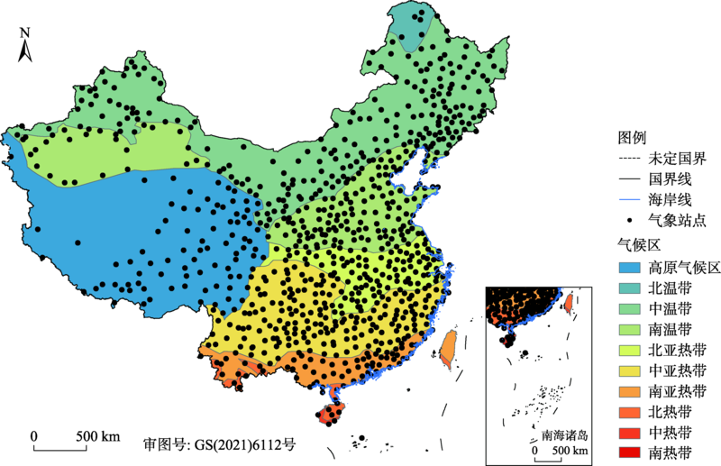
Fig. 1
Distributions of climatic areas and meteorological stations"
Tab. 1
Calculation formula of indicators used to evaluate ERA5 data"
| 统计指标 | 计算公式 | 取值范围 | 最优值 |
|---|---|---|---|
| Pearson相关系数(r) | | [-1, 1] | 1 |
| 均方根误差(RMSE) | | [0, +∞] | 0 |
| 平均绝对误差(MAE) | | [0, +∞] | 0 |
| 探测率(POD) | | [0, 1] | 1 |
| 误报率(FAR) | | [0, 1] | 0 |
| 公正先兆评分(ETS) | | [-1/3, 1] | 1 |
Tab. 2
Drought grade division based on standardized precipitation index (SPI)"
| 类型 | 标准化降水指数(SPI) |
|---|---|
| 无旱 | SPI>-0.5 |
| 轻旱 | -1.0<SPI≤-0.5 |
| 中旱 | -1.5<SPI≤-1.0 |
| 重旱 | -2.0<SPI≤-1.5 |
| 特旱 | SPI≤-2.0 |
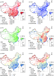
Fig. 2
Overall accuracy of ERA5 precipitation data"


Fig. 3
Accuracy of ERA5 precipitation data in different months and seasons"
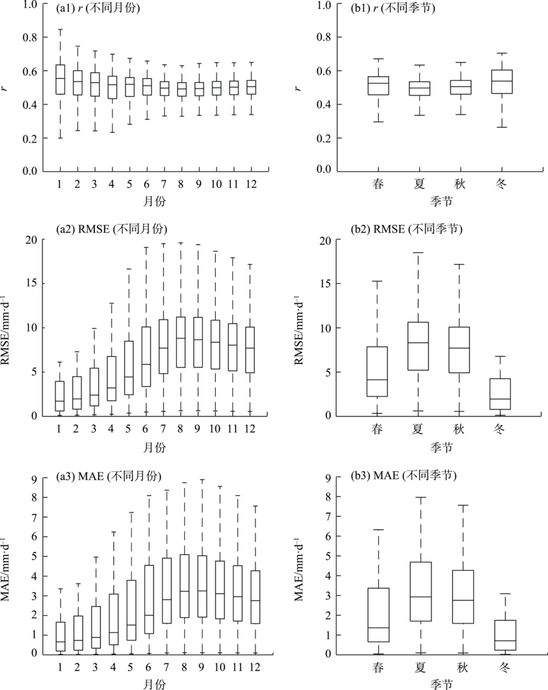
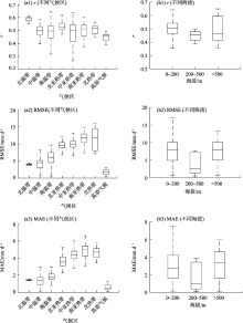
Fig. 4
Accuracy of ERA5 precipitation data in different climate zones and elevation gradients"

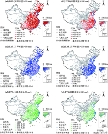
Fig. 5
Identification accuracy of heavy rain event based on ERA5"

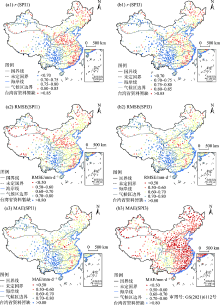
Fig. 6
Accuracy of SPI1 and SPI3 calculated by ERA5"

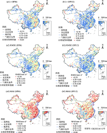
Fig. 7
Accuracy of SPI6 and SPI12 calculated by ERA5"

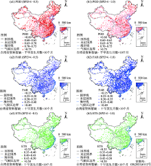
Fig. 8
Accuracy of ERA5 in recognizing drought with the thresholds of -0.5 and -1.0"

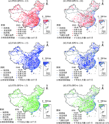
Fig. 9
Accuracy of ERA5 in recognizing drought with thresholds of -1.5 and -2.0"

Tab. 3
Mean values of POD, FAR and ETS in each climate zone with threshold of -0.5 for drought identification"
| 气候区 | 探测率(POD) | 误报率(FAR) | 公平先兆评分(ETS) |
|---|---|---|---|
| 高原气候区 | 0.653 | 0.334 | 0.351 |
| 北温带 | 0.717 | 0.291 | 0.419 |
| 中温带 | 0.685 | 0.302 | 0.386 |
| 南温带 | 0.693 | 0.295 | 0.401 |
| 北亚热带 | 0.706 | 0.298 | 0.403 |
| 中亚热带 | 0.661 | 0.327 | 0.356 |
| 南亚热带 | 0.688 | 0.305 | 0.388 |
| 北热带 | 0.662 | 0.326 | 0.352 |
| [1] | 夏军, 谈戈. 全球变化与水文科学新的进展与挑战[J]. 资源科学, 2002, 24(3):1-7. |
| [Xia Jun, Tan Ge. Hydrological science towards global change: Progress and challenge[J]. Resources Science, 2002, 24(3):1-7. ] | |
| [2] |
Adler R F, Huffman G J, Chang A, et al. The version-2 global precipitation climatology project (GPCP) monthly precipitation analysis (1979-present)[J]. Journal of hydrometeorology, 2003, 4(6):1147-1167.
doi: 10.1175/1525-7541(2003)004<1147:TVGPCP>2.0.CO;2 |
| [3] | 谈戈, 夏军, 李新. 无资料地区水文预报研究的方法与出路[J]. 冰川冻土, 2004, 26(2):192-196. |
| [Tan Ge, Xia Jun, Li Xin. Hydrological prediction in ungauged basins[J]. Journal of Glaciology and Geocryology, 2004, 26(2):192-196. ] | |
| [4] |
Su F, Hong Y, Lettenmaier D P. Evaluation of TRMM multisatellite precipitation analysis (TMPA) and its utility in hydrologic prediction in the La Plata Basin[J]. Journal of Hydrometeorology, 2008, 9(4):622-640.
doi: 10.1175/2007JHM944.1 |
| [5] | 黄建平, 张国龙, 于海鹏, 等. 黄河流域近40年气候变化的时空特征[J]. 水利学报, 2020, 51(9):1048-1058. |
| [Huang Jianping, Zhang Guolong, Yu Haipeng, et al. Characteristics of climate change in the Yellow River Basin during recent 40 years[J]. Journal of Hydraulic Engineering, 2020, 51(9):1048-1058. ] | |
| [6] | 黄颖, 毛文茜, 王潇雅, 等. 近39 a祁连山及其周边地区降水量时空分布特征[J]. 干旱气象, 2020, 38(4):527-534. |
| [Huang Ying, Mao Wenqian, Wang Xiaoya, et al. Temporal and spatial distribution of precipitation in the Qilian Mountain and its surrounding areas in recent 39 years[J]. Journal of Arid Meteorology, 2020, 38(4):527-534. ] | |
| [7] | 赵建婷, 王艳君, 苏布达, 等. 印度河流域气温、降水、蒸发及干旱变化特征[J]. 干旱区地理, 2020, 43(2):72-82. |
| [Zhao Jianting, Wang Yanjun, Su Buda, et al. Spatiotemporal distributions of temperature, precipitation, evapotranspiration, and drought in the Indus River Basin[J]. Arid Land Geography, 2020, 43(2):72-82. ] | |
| [8] | 徐昆, 朱秀芳, 刘莹, 等. 采用AquaCrop作物生长模型研究中国玉米干旱脆弱性[J]. 农业工程学报, 2020, 36(1):154-161. |
| [Xu Kun, Zhu Xiufang, Liu Ying, et al. Vulnerability of drought disaster of maize in China based on AquaCrop model[J]. Transactions of the Chinese Society of Agricultural Engineering, 2020, 36(1):154-161. ] | |
| [9] | 徐昆, 朱秀芳, 刘莹, 等. 气候变化下干旱对中国玉米产量的影响[J]. 农业工程学报, 2020, 36(11):149-158. |
| [Xu Kun, Zhu Xiufang, Liu Ying, et al. Effects of drought on maize yield under climate change in China[J]. Transactions of the Chinese Society of Agricultural Engineering, 2020, 36(11):149-158. ] | |
| [10] | 张小丽, 彭勇, 王本德, 等. 基于SWAT模型的降雨数据适用性评价[J]. 农业工程学报, 2014, 30(19):88-96. |
| [Zhang Xiaoli, Peng Yong, Wang Bende, et al. Suitability evaluation of precipitation data using SWAT model[J]. Transactions of the Chinese Society of Agricultural Engineering, 2014, 30(19):88-96. ] | |
| [11] | 焦振航, 舒红, 吴凯, 等. 降水驱动数据改进对VIC土壤湿度模拟的影响[J]. 城市勘测, 2017(4):37-41. |
| [Jiao Zhenhang, Shu Hong, Wu Kai, et al. The rainfall calibration methods’ impact on VIC soil moisture simulation[J]. Urban Surveying, 2017(4):37-41. ] | |
| [12] |
Tarek M, Brissette F P, Arsenault R. Evaluation of the ERA5 reanalysis as a potential reference dataset for hydrological modelling over North America[J]. Hydrology and Earth System Sciences, 2020, 24(5):2527-2544.
doi: 10.5194/hess-24-2527-2020 |
| [13] | 冯克鹏, 洪阳, 田军仓, 等. 多源降水数据的小流域水文模拟效用评估[J]. 干旱区地理, 2020, 43(5):1179-1191. |
| [Feng Kepeng, Hong Yang, Tian Juncang, et al. Evaluating runoff simulation of multi-source precipitation data in small watersheds[J]. Arid Land Geography, 2020, 43(5):1179-1191. ] | |
| [14] |
Albergel C, Dutra E, Munier S, et al. ERA-5 and ERA-Interim driven ISBA land surface model simulations: Which one performs better?[J]. Hydrology and Earth System Sciences, 2018, 22(6):3515-3532.
doi: 10.5194/hess-22-3515-2018 |
| [15] | 韦芬芬, 汤剑平, 王淑瑜. 中国区域夏季再分析资料高空变量可信度的检验[J]. 地球物理学报, 2015, 58(2):383-397. |
| [Wei Fenfen, Tang Jianping, Wang Shuyu. A reliability assessment of upper-level reanalysis datasets over China[J]. Chinese Journal of Geophysics, 2015, 58(2):383-397. ] | |
| [16] | 胡增运, 倪勇勇, 邵华, 等. CFSR, ERA-Interim和MERRA降水资料在中亚地区的适用性[J]. 干旱区地理, 2013, 36(4):700-708. |
| [Hu Zengyun, Ni Yongyong, Shao Hua, et al. Applicability study of CFSR, ERA-Interim and MERRA precipitation estimates in Central Asia[J]. Arid Land Geography, 2013, 36(4):700-708. ] | |
| [17] |
Hersbach H, Bell B, Berrisford P, et al. The ERA5 global reanalysis[J]. Quarterly Journal of the Royal Meteorological Society, 2020, 146(730):1999-2049.
doi: 10.1002/qj.v146.730 |
| [18] |
Graham R M, Hudson S R, Maturilli M. Improved performance of ERA5 in Arctic gateway relative to four global atmospheric reanalyses[J]. Geophysical Research Letters, 2019, 46(11):6138-6147.
doi: 10.1029/2019GL082781 |
| [19] |
Hénin R, Liberato M L, Ramos A M, et al. Assessing the use of satellite-based estimates and high-resolution precipitation datasets for the study of extreme precipitation events over the Iberian Peninsula[J]. Water, 2018, 10(11):1688, doi: 10.3390/w10111688.
doi: 10.3390/w10111688 |
| [20] |
Wang C, Graham R M, Wang K, et al. Comparison of ERA5 and ERA-Interim near-surface air temperature, snowfall and precipitation over Arctic sea ice: Effects on sea ice thermodynamics and evolution[J]. The Cryosphere, 2019, 13(6):1661-1679.
doi: 10.5194/tc-13-1661-2019 |
| [21] |
Betts A K, Chan D Z, Desjardins R L. Near-surface biases in ERA5 over the Canadian prairies[J]. Frontiers in Environmental Science, 2019, 7:129, doi: 10.3389/fenvs.2019.00129.
doi: 10.3389/fenvs.2019.00129 |
| [22] |
Beck H E, Pan M, Roy T, et al. Daily evaluation of 26 precipitation datasets using Stage-IV gauge-radar data for the CONUS[J]. Hydrology and Earth System Sciences, 2019, 23(1):207-224.
doi: 10.5194/hess-23-207-2019 |
| [23] |
Nogueira M. Inter-comparison of ERA-5, ERA-interim and GPCP rainfall over the last 40 years: Process-based analysis of systematic and random differences[J]. Journal of Hydrology, 2020, 583:124632, doi: 10.1016/j.jhydrol.2020.124632.
doi: 10.1016/j.jhydrol.2020.124632 |
| [24] |
Xu X, Frey S K, Boluwade A, et al. Evaluation of variability among different precipitation products in the Northern Great Plains[J]. Journal of Hydrology: Regional Studies, 2019, 24:100608, doi: 10.1016/j.ejrh.2019.100608.
doi: 10.1016/j.ejrh.2019.100608 |
| [25] |
Amjad M, Yilmaz M T, Yucel I, et al. Performance evaluation of satellite-and model-based precipitation products over varying climate and complex topography[J]. Journal of Hydrology, 2020, 584:124707, doi: 10.1016/j.jhydrol.2020.124632.
doi: 10.1016/j.jhydrol.2020.124632 |
| [26] |
Fallah A, Rakhshandehroo G R, Berg P, et al. Evaluation of precipitation datasets against local observations in southwestern Iran[J]. International Journal of Climatology, 2020, 40(9):4102-4116.
doi: 10.1002/joc.v40.9 |
| [27] |
Jiang Q, Li W, Fan Z, et al. Evaluation of the ERA5 reanalysis precipitation dataset over Chinese Mainland[J]. Journal of Hydrology, 2020: 125660, doi: 10.1016/j.jhydrol.2020.125660.
doi: 10.1016/j.jhydrol.2020.125660 |
| [28] | 成晓裕, 王艳华, 李国春, 等. 三套再分析降水资料在中国区域的对比评估[J]. 气候变化研究进展, 2013, 9(4):258-265. |
| [Cheng Xiaoyu, Wang Yanhua, Li Guochun, et al. Evaluation of three reanalysis precipitation datasets in China[J]. Climate Change Research, 2013, 9(4):258-265. ] | |
| [29] | 孙葭, 章新平, 黄一民. 不同再分析降水数据在洞庭湖流域的精度评估[J]. 长江流域资源与环境, 2015, 24(11):1850-1859. |
| [Sun Jia, Zhang Xinping, Huang Yimin. Evaluation of precipitation from ERA-Interim, CRU, GPCP and TRMM reanalysis data in the Dongting Lake Basin[J]. Resources and Environment in the Yangtze Basin, 2015, 24(11):1850-1859. ] | |
| [30] | 刘鹏飞, 刘丹丹, 梁丰, 等. 三套再分析降水资料在东北地区的适用性评价[J]. 水土保持研究, 2018, 25(4):215-221. |
| [Liu Pengfei, Liu Dandan, Liang Feng, et al. Comparison the adaptability of CFSR, MERRA, NCEP reanalysis precipitation data and observation in northeast China[J]. Research of Soil and Water Conservation, 2018, 25(4):215-221. ] |
| [1] | LIU Wenli, CHEN Zhang, ZHAO Yong, LIANG Yuxin. Influences of soil moisture anomalies in May on June precipitation in Central Asia [J]. Arid Land Geography, 2024, 47(1): 38-47. |
| [2] | SHI Weiliang, CHE Luyang, LI Tao. Probability distribution and comprehensive risk assessment of extreme precipitation in flood season in Shaanxi Province [J]. Arid Land Geography, 2023, 46(9): 1407-1417. |
| [3] | NIU Yiying, LI Chunlan, WANG Jun, XU Hanqing, LIU Qing. Performance evaluation of ERA5 reanalysis precipitation data and spatiotemporal characteristics of extreme precipitation in Inner Mongolia [J]. Arid Land Geography, 2023, 46(9): 1418-1431. |
| [4] | LU Dongyan, ZHU Xiufang, LIU Tingting, ZHANG Shizhe. Changes in meteorological drought characteristics in China under the 2 ℃ temperature rise scenario [J]. Arid Land Geography, 2023, 46(8): 1227-1237. |
| [5] | HUANG Xin, JIAO Li, MA Xiaofei, WANG Yonghui, Aerman ABULA. Change characteristics of extreme precipitation events in Central Asia in recent 60 years based on RClimDex model [J]. Arid Land Geography, 2023, 46(7): 1039-1051. |
| [6] | BAI He, MING Yisen, LIU Qihang, HUANG Chang. Downscaling of GPM satellite precipitation data in the Yellow River Basin based on MGWR model [J]. Arid Land Geography, 2023, 46(7): 1052-1062. |
| [7] | CHENG Shuo, LI Yanzhong, XING Yincong, YU Zhiguo, WANG Yuangang, HUANG Manjie. Simulation performance of remote sensing precipitation products on hydrological drought characteristics in the source region of the Yellow River [J]. Arid Land Geography, 2023, 46(7): 1063-1072. |
| [8] | SHI Jiqing, GAN Chenlong, ZHOU Kanshe, YUAN Lei, ZHANG Dongdong. Spatiotemporal distribution of drought and hazard assessment of highland barley in Tibet [J]. Arid Land Geography, 2023, 46(7): 1098-1110. |
| [9] | WANG Jianian, LI Xiangyi, LI Chengdao, ZHANG Ailin, LIN Lisha. Decomposition characteristics of two desert plant leaf under natural light and shade environment [J]. Arid Land Geography, 2023, 46(6): 949-957. |
| [10] | QIU Huimin, WAN Yu, ZHANG Shiming, XIAO Lianyuan, ZHOU Xueying, WEN Chun, JIANG Jujin. Meteorological factor characteristic and index of precipitation types during winter half year in northern Bayingol Prefecture of Xinjiang [J]. Arid Land Geography, 2023, 46(4): 563-573. |
| [11] | REN Taotao,LI Shuangshuang,DUAN Keqin,HE Jinping. Spatiotemporal variation characteristics and influencing factors of heat wave and precipitation deficit flash drought in the Loess Plateau [J]. Arid Land Geography, 2023, 46(3): 360-370. |
| [12] | XU Xintong,ZHU Li,LYU Xiaoyu,GUO Hao. Applicability evaluation of MSWEP product for meteorological drought monitoring in the Yellow River Basin [J]. Arid Land Geography, 2023, 46(3): 371-384. |
| [13] | SUN Nansha,CHEN Qiong,LIU Fenggui,ZHOU Qiang,GUO Yuanyuan. Agricultural drought research in Yellow River-Huangshui River Valley from 2000 to 2020 [J]. Arid Land Geography, 2023, 46(3): 437-447. |
| [14] | DIAO Peng,LI Gang,YUAN Xianlei,WEN Chun. Effect of artificial precipitation enhancement in Bayanbulak mountain area in warm seasons based on Budyko model [J]. Arid Land Geography, 2023, 46(12): 1963-1972. |
| [15] | CAO Yujuan, SI Wenyang, DU Ziqiang, LIANG Hanxue, LEI Tianjie, SUN Bin, WU Zhitao. Changes in GPP of China during the typical drought years from 1982 to 2017 [J]. Arid Land Geography, 2023, 46(10): 1577-1590. |
|
||