- Aug. 5, 2025
Arid Land Geography ›› 2023, Vol. 46 ›› Issue (7): 1052-1062.doi: 10.12118/j.issn.1000-6060.2022.475
• Climatology and Hydrology • Previous Articles Next Articles
BAI He1,2( ),MING Yisen1,2,LIU Qihang1,2,HUANG Chang1,2,3()
Received:2022-09-21
Revised:2022-11-17
Online:2023-07-25
Published:2023-08-03
BAI He, MING Yisen, LIU Qihang, HUANG Chang. Downscaling of GPM satellite precipitation data in the Yellow River Basin based on MGWR model[J].Arid Land Geography, 2023, 46(7): 1052-1062.
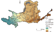
Fig. 1
Distribution of meteorological stations in the Yellow River Basin"

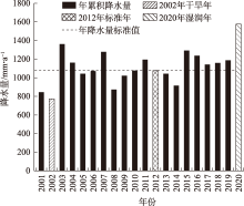
Fig. 2
Annual precipitation accumulation in the Yellow River Basin from 2001 to 2020"

Tab. 1
Difference standard values of accessory factors"
| 辅助因子 | 2002年 | 2012年 | 2020年 |
|---|---|---|---|
| DEM | -13792.4780 | 111.5426 | -38.1083 |
| NDVI | -10307.8175 | -14268.9533 | -11486.5637 |
| WDS | -13864.9890 | -12589.8497 | -11786.7153 |
| Slope | 283.4418 | 329.9034 | 374.2292 |
| LST | 291.0240 | -6264.2374 | 227.1289 |
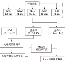
Fig. 3
Downscaling flow chart of MGWR model"
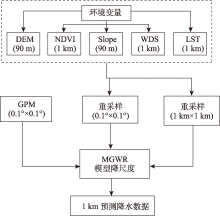
Fig. 4
Downscaling flow chart of GWR model"
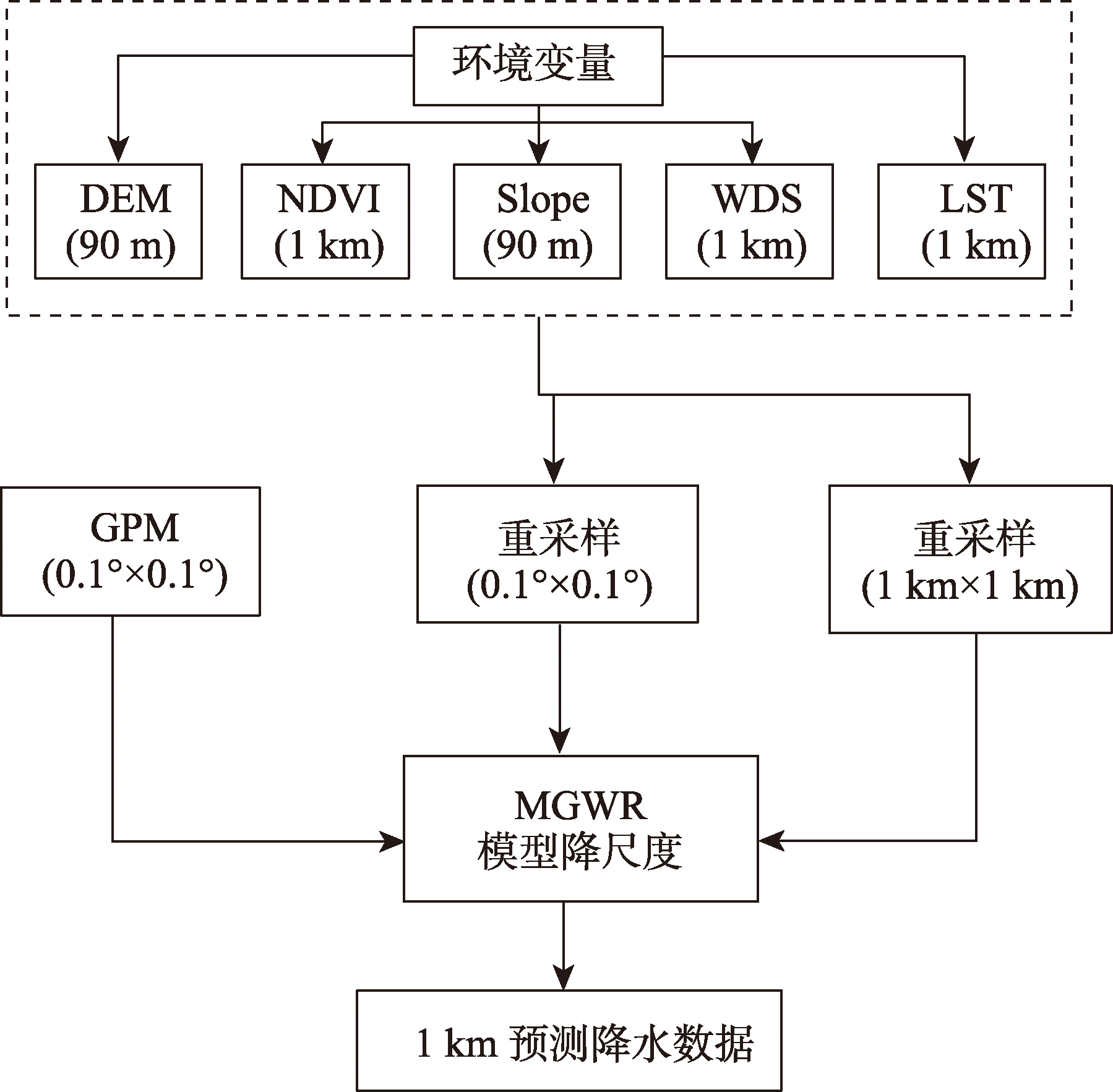
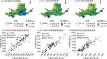
Fig. 5
Spatial distribution and accuracy verification of GPM satellite annual precipitation in the Yellow River Basin"
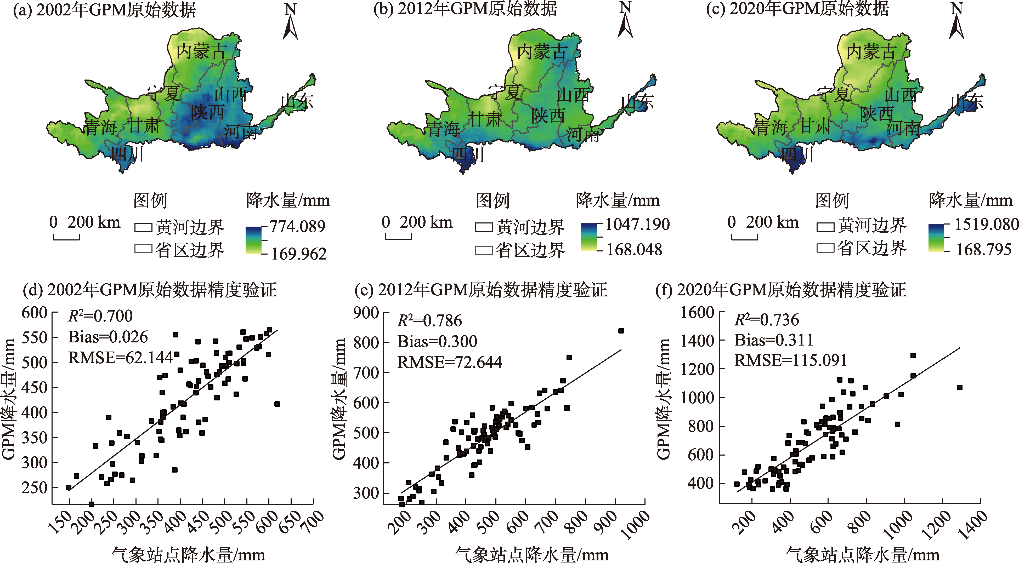
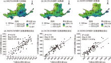
Fig. 6
Spatial distribution and accuracy verification of GWR downscaling data of annual precipitation in the Yellow River Basin"

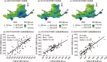
Fig. 7
Spatial distribution and accuracy verification of MGWR downscaling data of annual precipitation in the Yellow River Basin"

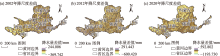
Fig. 8
Spatial distribution of downscaling differences in the Yellow River Basin"

Tab. 2
Verification of downscaling results in different years"
| 评价指标 | 年份 | GPM | GWR | MGWR |
|---|---|---|---|---|
| R2 | 2002 | 0.700 | 0.670 | 0.598 |
| 2012 | 0.786 | 0.773 | 0.690 | |
| 2020 | 0.736 | 0.683 | 0.688 | |
| Bias | 2002 | 0.026 | 0.029 | 0.022 |
| 2012 | 0.300 | 0.300 | -0.092 | |
| 2020 | 0.311 | 0.309 | 0.154 | |
| RMSE | 2002 | 62.144 | 65.482 | 71.950 |
| 2012 | 72.644 | 73.940 | 92.269 | |
| 2020 | 115.091 | 134.041 | 134.229 |
| [1] |
Michaelides S, Levizzani V, Anagnostou E, et al. Precipitation: Measurement, remote sensing, climatology and modeling[J]. Atmospheric Research, 2009, 94(4): 512-533.
doi: 10.1016/j.atmosres.2009.08.017 |
| [2] |
Pipunic R C, Ryu D, Costelloe J F, et al. An evaluation and regional error modeling methodology for near-real-time satellite rainfall data over Australia[J]. Journal of Geophysical Research: Atmospheres, 2015, 120(20): 10767-10783.
doi: 10.1002/2015JD023512 |
| [3] | Kang E, Cheng G, Lan Y, et al. A model for simulating the response of runoff from the mountainous watersheds of inland river basins in the arid area of northwest China to climatic changes[J]. Science in China Series D: Earth Sciences, 1999, 42(1): 52-63. |
| [4] | 唐国强, 万玮, 曾子悦, 等. 全球降水测量(GPM)计划及其最新进展综述[J]. 遥感技术与应用, 2015, 30(4): 607-615. |
| [Tang Guoqiang, Wan Wei, Zeng Ziyue, et al. An overview of the global precipitation measurement (GPM) mission and it’s latest development[J]. Remote Sensing Technology and Application, 2015, 30(4): 607-615.] | |
| [5] | 田亚林, 李雪梅, 李珍, 等. 1980—2017年天山山区不同降水形态的时空变化[J]. 干旱区地理, 2020, 43(2): 308-318. |
| [Tian Yalin, Li Xuemei, Li Zhen, et al. Spatial and temporal variations of different precipitation types in the Tianshan Mountains from 1980 to 2017[J]. Arid Land Geography, 2020, 43(2): 308-318.] | |
| [6] |
肖柳斯, 张阿思, 闵超, 等. GPM卫星降水产品在台风极端降水过程的误差评估[J]. 高原气象, 2019, 38(5): 993-1003.
doi: 10.7522/j.issn.1000-0534.2018.00143 |
|
[Xiao Liusi, Zhang Asi, Min Chao, et al. Evaluation of GPM satellite-based precipitation estimates during three tropical-related extreme rainfall events[J]. Plateau Meteorology, 2019, 38(5): 993-1003.]
doi: 10.7522/j.issn.1000-0534.2018.00143 |
|
| [7] | Hsu K, Gao X, Sorooshian S, et al. Precipitation estimation from remotely sensed information using artificial neural networks[J]. Journal of Applied Meteorology and Climatology, American Meteorological Society, 1997, 36(9): 1176-1190. |
| [8] |
Hsu K, Gupta H V, Gao X, et al. Estimation of physical variables from multichannel remotely sensed imagery using a neural network: Application to rainfall estimation[J]. Water Resources Research, 1999, 35(5): 1605-1618.
doi: 10.1029/1999WR900032 |
| [9] |
Sorooshian S, Hsu K, Gao X, et al. Evaluation of PERSIANN system satellite-based estimates of tropical rainfall[J]. Bulletin of the American Meteorological Society, 2000, 81(9): 2035-2046.
doi: 10.1175/1520-0477(2000)081<2035:EOPSSE>2.3.CO;2 |
| [10] |
Huffman G J, Adler R F, Arkin P, et al. The global precipitation climatology project (GPCP) combined precipitation dataset[J]. Bulletin of the American Meteorological Society, 1997, 78(1): 5-20.
doi: 10.1175/1520-0477(1997)078<0005:TGPCPG>2.0.CO;2 |
| [11] |
Huffman G J, Adler R F, Bolvin D T, et al. Improving the global precipitation record: GPCP Version 2.1[J]. Geophysical Research Letters, 2009, 36(17): L17808, doi: 10.1029/2009GL040000.
doi: 10.1029/2009GL040000 |
| [12] | Huffman G J, Bolvin D T, Nelkin E J, et al. The TRMM multisatellite precipitation analysis (TMPA): Quasi-global, multiyear, combined-sensor precipitation estimates at fine scales[J]. Journal of Hydrometeorology, American Meteorological Society, 2007, 8(1): 38-55. |
| [13] | Huffman G J, Bolvin D T, Braithwaite D, et al. NASA global precipitation measurement (GPM) integrated multi-satellite retrievals for GPM (IMERG)[R]. Greenbelt: National Aeronautics and Space Administration (NASA), 2014. |
| [14] |
Anjum M N, Ding Y, Shangguan D, et al. Performance evaluation of latest integrated multi-satellite retrievals for global precipitation measurement (IMERG) over the northern highlands of Pakistan[J]. Atmospheric Research, 2018, 205: 134-146.
doi: 10.1016/j.atmosres.2018.02.010 |
| [15] |
Tan M L, Duan Z. Assessment of GPM and TRMM precipitation products over Singapore[J]. Remote Sensing, Multidisciplinary Digital Publishing Institute, 2017, 9(7): 720, doi: 10.3390/rs9070720.
doi: 10.3390/rs9070720 |
| [16] |
Chen F, Li X. Evaluation of IMERG and TRMM 3B43 monthly precipitation products over mainland China[J]. Remote Sensing, Multidisciplinary Digital Publishing Institute, 2016, 8(6): 472, doi: 10.3390/rs8060472.
doi: 10.3390/rs8060472 |
| [17] |
Xu S G, Wu C Y, Wang L, et al. A new satellite-based monthly precipitation downscaling algorithm with non-stationary relationship between precipitation and land surface characteristics[J]. Remote Sensing of Environment, 2015, 162: 119-140.
doi: 10.1016/j.rse.2015.02.024 |
| [18] |
Duan Z, Bastiaanssen W G M. First results from Version 7 TRMM 3B43 precipitation product in combination with a new downscaling-calibration procedure[J]. Remote Sensing of Environment, 2013, 131: 1-13.
doi: 10.1016/j.rse.2012.12.002 |
| [19] |
Wilby R L, Wigley T M L. Downscaling general circulation model output: A review of methods and limitations[J]. Progress in Physical Geography: Earth and Environment, 1997, 21(4): 530-548.
doi: 10.1177/030913339702100403 |
| [20] |
Immerzeel W W, Rutten M M, Droogers P. Spatial downscaling of TRMM precipitation using vegetative response on the Iberian Peninsula[J]. Remote Sensing of Environment, 2009, 113(2): 362-370.
doi: 10.1016/j.rse.2008.10.004 |
| [21] |
Jia S, Zhu W, Lü A, et al. A statistical spatial downscaling algorithm of TRMM precipitation based on NDVI and DEM in the Qaidam Basin of China[J]. Remote Sensing of Environment, 2011, 115(12): 3069-3079.
doi: 10.1016/j.rse.2011.06.009 |
| [22] | 温伯清, 刘戎, 庞国伟, 等. GPM卫星降水数据的降尺度研究——以陕西省为例[J]. 干旱区地理, 2021, 44(3): 786-795. |
| [Wen Boqing, Liu Rong, Pang Guowei, et al. Downscaling study of GPM satellite precipitation data: A case study of Shaanxi Province[J]. Arid Land Geography, 2021, 44(3): 786-795.] | |
| [23] | 曾昭昭, 王晓峰, 任亮. 基于GWR模型的陕西秦巴山区TRMM降水数据降尺度研究[J]. 干旱区地理, 2017, 40(1): 26-36. |
| [Zeng Zhaozhao, Wang Xiaofeng, Ren Liang. Spatial downscaling of TRMM rainfall data based on GWR model for Qinling-Daba Mountains in Shaanxi Province[J]. Arid Land Geography, 2017, 40(1): 26-36.] | |
| [24] | 崔路明, 王思梦, 刘轶欣, 等. TRMM和GPM卫星降水数据在中国三大流域的降尺度对比研究[J]. 长江流域资源与环境, 2021, 30(6): 1317-1328. |
| [Cui Luming, Wang Simeng, Liu Yixin, et al. Comparative study on downscaling of TRMM and GPM satellite precipitation data in three major river basins in China[J]. Resources and Environment in the Yangtze Basin, 2021, 30(6): 1317-1328.] | |
| [25] |
Bohnenstengel S I, Schlünzen K H, Beyrich F. Representativity of in situ precipitation measurements: A case study for the LITFASS area in north-eastern Germany[J]. Journal of Hydrology, 2011, 400(3): 387-395.
doi: 10.1016/j.jhydrol.2011.01.052 |
| [26] |
Marzano F S, Cimini D, Montopoli M. Investigating precipitation microphysics using ground-based microwave remote sensors and disdrometer data[J]. Atmospheric Research, 2010, 97(4): 583-600.
doi: 10.1016/j.atmosres.2010.03.019 |
| [27] |
Arshad A, Zhang W, Zhang Z, et al. Reconstructing high-resolution gridded precipitation data using an improved downscaling approach over the high altitude mountain regions of upper Indus Basin (UIB)[J]. Science of the Total Environment, 2021, 784: 147140, doi: 10.1016/j.scitotenv.2021.147140.
doi: 10.1016/j.scitotenv.2021.147140 |
| [28] | 张小兵, 柳礼香. 1998—2018年黄河流域水资源变化特征研究[J]. 地下水, 2020, 42(5): 187-189, 291. |
| [Zhang Xiaobing, Liu Lixiang. Study on the change characteristics of water resources in the Yellow River Basin from 1998 to 2018[J]. Ground Water, 2020, 42(5): 187-189, 291.] | |
| [29] | 王澄海, 杨金涛, 杨凯, 等. 过去近60 a黄河流域降水时空变化特征及未来30 a变化趋势[J]. 干旱区研究, 2022, 39(3): 708-722. |
| [Wang Chenghai, Yang Jintao, Yang Kai, et al. Changing precipitation characteristics in the Yellow River Basin in the last 60 years and tendency prediction for next 30 years[J]. Arid Zone Research, 2022, 39(3): 708-722.] | |
| [30] | 杨飞, 张成业, 李军, 等. 基于GRACE的黄河流域陆地水储量时空变化研究[J]. 煤田地质与勘探, 2022, 52(4): 106-112. |
| [Yang Fei, Zhang Chengye, Li Jun, et al. Temporal and spatial changes of terrestrial water storage in Yellow River Basin based on GRACE[J]. Coal Geology & Exploration, 2022, 52(4): 106-112.] | |
| [31] | 付含培, 王让虎, 王晓军. 1999—2018年黄河流域NDVI时空变化及驱动力分析[J]. 水土保持研究, 2022, 29(2): 145-153, 162. |
| [Fu Hanpei, Wang Ranghu, Wang Xiaojun. Analysis of spatiotemporal variations and driving forces of NDVI in the Yellow River Basin during 1999—2018[J]. Research of Soil and Water Conservation, 2022, 29(2): 145-153, 162.] | |
| [32] | Brunsdon C, Fotheringham S, Charlton M. Geographically weighted regression-modelling spatial non-stationarity[J]. Journal of the Royal Statistical Society. Series D (The Statistician), 1998, 47(3): 431-443. |
| [33] |
Brunsdon C, Fotheringham A S, Charlton M. Some notes on parametric significance tests for geographically weighted regression[J]. Journal of Regional Science, 1999, 39(3): 497-524.
doi: 10.1111/jors.1999.39.issue-3 |
| [34] |
Mei C L, He S Y, Fang K T. A note on the mixed geographically weighted regression model[J]. Journal of Regional Science, 2004, 44(1): 143-157.
doi: 10.1111/j.1085-9489.2004.00331.x |
| [35] | 郭妍. 陕西省TRMM降水数据反演精度的时空分布特征研究[D]. 咸阳: 西北农林科技大学, 2017. |
| [Guo Yan. Spatlal & time distribution characteristics of retrieval accuracy on TRMM percipitation data in Shaanxi Province[D]. Xianyang: Northwest Agriculture & Forestry University, 2017.] |
| Viewed | ||||||||||||||||||||||||||||||||||||||||||||||||||
|
Full text 130
|
|
|||||||||||||||||||||||||||||||||||||||||||||||||
|
Abstract 427
|
|
|||||||||||||||||||||||||||||||||||||||||||||||||
Cited |
|
|||||||||||||||||||||||||||||||||||||||||||||||||
| Shared | ||||||||||||||||||||||||||||||||||||||||||||||||||
|
||