- Jul. 28, 2025
Arid Land Geography ›› 2021, Vol. 44 ›› Issue (4): 1175-1185.doi: 10.12118/j.issn.1000–6060.2021.04.29
• Regional Development • Previous Articles Next Articles
HUANG Yue1( ),CHENG Jing2(),WANG Peng2
Received:2020-06-12
Revised:2020-12-31
Online:2021-07-25
Published:2021-08-02
Contact:
Jing CHENG
E-mail:284921758@qq.com;958830559@qq.com
HUANG Yue,CHENG Jing,WANG Peng. Spatiotemporal evolution pattern and driving factors of ecological vulnerability in agro-pastoral region in northern China: A case of Yanchi County in Ningxia[J].Arid Land Geography, 2021, 44(4): 1175-1185.

Fig. 1
Geographical location of study area"

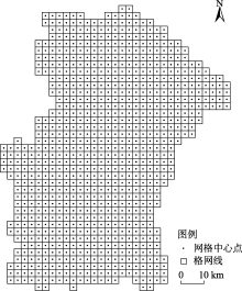
Fig. 2
Division of evaluation units"

Tab. 1
Landscape area change of Yanchi County during 2000—2017"
| 年份 | 项目 | 耕地 | 林地 | 草地 | 水域 | 建设用地 | 未利用地 |
|---|---|---|---|---|---|---|---|
| 2000 | 面积/hm2 | 214131.27 | 83211.15 | 377689.95 | 9220.58 | 25777.45 | 127698.94 |
| 比例/% | 25.56 | 9.93 | 45.08 | 1.10 | 3.08 | 15.24 | |
| 2008 | 面积/hm2 | 189927.18 | 105415.27 | 412605.18 | 11267.99 | 32484.44 | 86029.31 |
| 比例/% | 22.67 | 12.58 | 49.25 | 1.35 | 3.88 | 10.27 | |
| 2017 | 面积/hm2 | 169457.57 | 123698.84 | 430485.28 | 12595.88 | 46825.93 | 54665.84 |
| 比例/% | 20.23 | 14.77 | 51.39 | 1.50 | 5.59 | 6.53 | |
| 2000—2008 | 变化率/% | -0.66 | 1.57 | 0.54 | 1.31 | 1.53 | -1.92 |
| 2008—2017 | 变化率/% | -0.63 | 1.02 | 0.25 | 0.69 | 2.60 | -2.14 |
| 2000—2017 | 变化率/% | -1.23 | 2.86 | 0.82 | 2.15 | 4.80 | -3.36 |
Tab. 2
Index of landscape pattern of Yanchi County during 2000—2017"
| 景观类型 | 年份 | 斑块密度/块·hm-2 | 边缘密度/m·hm-2 | 最大斑块指数/% | 平均斑块面积/hm2 |
|---|---|---|---|---|---|
| 耕地 | 2000 | 1.426 | 14.253 | 13.157 | 237.542 |
| 2008 | 1.539 | 16.557 | 11.036 | 212.375 | |
| 2017 | 1.692 | 17.952 | 10.268 | 199.483 | |
| 林地 | 2000 | 0.563 | 7.442 | 0.619 | 56.593 |
| 2008 | 0.497 | 6.129 | 0.843 | 62.469 | |
| 2017 | 0.423 | 5.622 | 1.236 | 69.342 | |
| 草地 | 2000 | 2.463 | 22.649 | 23.548 | 204.861 |
| 2008 | 2.169 | 19.429 | 25.529 | 396.483 | |
| 2017 | 1.837 | 17.449 | 27.334 | 475.252 | |
| 水域 | 2000 | 0.359 | 6.253 | 0.816 | 29.354 |
| 2008 | 0.372 | 5.972 | 0.849 | 35.559 | |
| 2017 | 0.409 | 6.128 | 0.926 | 39.608 | |
| 建设用地 | 2000 | 0.842 | 0.573 | 0.428 | 47.529 |
| 2008 | 0.719 | 0.591 | 0.627 | 52.267 | |
| 2017 | 0.568 | 0.463 | 0.934 | 59.346 | |
| 未利用地 | 2000 | 0.423 | 0.396 | 0.716 | 27.689 |
| 2008 | 0.476 | 0.463 | 0.529 | 25.466 | |
| 2017 | 0.545 | 0.579 | 0.337 | 22.537 |
Tab. 3
Landscape pattern index change of Yanchi County during 2000—2017"
| 年份 | 斑块数/个 | 面积加权平均形状指数 | 蔓延度指数 | 香浓多样性指数 | 香浓均匀度指数 |
|---|---|---|---|---|---|
| 2000 | 7647 | 24.68 | 59.15 | 0.91 | 0.64 |
| 2008 | 7269 | 21.19 | 58.49 | 0.89 | 0.62 |
| 2017 | 6873 | 19.43 | 58.05 | 0.88 | 0.61 |
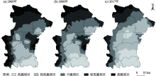
Fig. 3
Spatial distribution of ecological vulnerability in Yanchi County during 2000—2017"
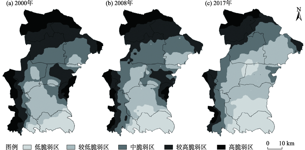
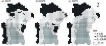
Fig. 4
Lisa spatial distribution of ecological vulnerability in Yanchi County during 2000—2017"

Tab. 4
Detection q value of influencing factors of ecological vulnerability in Yanchi County"
| 影响因素 | 2000年 | 2008年 | 2017年 |
|---|---|---|---|
| 景观斑块数 | 0.568 | 0.554 | 0.561 |
| 景观破碎度 | 0.627 | 0.593 | 0.546 |
| 景观分离度 | 0.455 | 0.376 | 0.439 |
| 景观优势度 | 0.469 | 0.522 | 0.573 |
| 景观易损度 | 0.433 | 0.416 | 0.429 |
| 香浓多样性指数 | 0.463 | 0.522 | 0.569 |
| 香浓均匀度指数 | 0.326 | 0.297 | 0.318 |
| 斑块密度指数 | 0.343 | 0.357 | 0.352 |
| [1] | 王贝贝, 丁明军, 管琪卉, 等. 基于格网的南昌市生态环境脆弱性评价[J]. 生态学报, 2019, 39(15):5460-5472. |
| [ Wang Beibei, Ding Mingjun, Guan Qihui, et al. Gridded assessment of eco-environmental vulnerability in Nanchang City[J]. Acta Ecologica Sinica, 2019, 39(15):5460-5472. ] | |
| [2] | 靳毅, 蒙吉军. 生态脆弱性评价与预测研究进展[J]. 生态学杂志, 2011, 30(11):2646-2652. |
| [ Jin Yi, Meng Jijun. Assessment and forecast of ecological vulnerability: A review[J]. Chinese Journal of Ecology, 2011, 30(11):2646-2652. ] | |
| [3] | 张学玲, 余文波, 蔡海生, 等. 区域生态环境脆弱性评价方法研究综述[J]. 生态学报, 2018, 38(16):5970-5981. |
| [ Zhang Xueling, Yu Wenbo, Cai Haisheng, et al. Review of the evaluation methods of regional eco-environmental vulnerability[J]. Acta Ecologica Sinica, 2018, 38(16):5970-5981. ] | |
| [4] | 田亚平, 常昊. 中国生态脆弱性研究进展的文献计量分析[J]. 地理学报, 2012, 67(11):1515-1525. |
| [ Tian Yaping, Chang Hao. Bibliometric analysis of research progress on ecological vulnerability in China[J]. Journal of Geographical Sciences, 2012, 67(11):1515-1525. ] | |
| [5] |
陈萍, 陈晓玲. 全球环境变化下人-环境耦合系统的脆弱性研究综述[J]. 地理科学进展, 2010, 29(4):454-462.
doi: 10.11820/dlkxjz.2010.04.010 |
|
[ Chen Ping, Chen Xiaoling. Summary on research of coupled human-environment system vulnerability under global environmental change[J]. Progress in Geography, 2010, 29(4):454-462. ]
doi: 10.11820/dlkxjz.2010.04.010 |
|
| [6] | 刘晶, 刘学录, 侯莉敏. 祁连山东段山地景观格局变化及其生态脆弱性分析[J]. 干旱区地理, 2012, 35(5):795-805. |
| [ Liu Jing, Liu Xuelu, Hou Limin. Mountain landscape pattern changes and ecological vulnerability analysis in the eastern part of Qilian Mountains[J]. Arid Land Geography, 2012, 35(5):795-805. ] | |
| [7] | 贾晶晶, 赵军, 王建邦, 等. 基于SRP模型的石羊河流域生态脆弱性评价[J]. 干旱区资源与环境, 2020, 34(1):34-41. |
| [ Jia Jingjing, Zhao Jun, Wang Jianbang, et al. Ecological vulnerability assessment of Shiyang River Basin based on SRP model[J]. Journal of Arid Land Resources and Environment, 2020, 34(1):34-41. ] | |
| [8] | 田鹏, 李加林, 姜忆湄, 等. 海湾景观生态脆弱性及其对人类活动的响应——以东海区为例[J]. 生态学报, 2019, 39(4):1463-1474. |
| [ Tian Peng, Li Jialin, Jiang Yimei, et al. Ecological vulnerability of the bay landscape and its response to human activities: A case study of the East China Sea[J]. Acta Ecologica Sinica, 2019, 39(4):1463-1474. ] | |
| [9] | 付刚, 白加德, 齐月, 等. 基于GIS的北京市生态脆弱性评价[J]. 生态与农村环境学报, 2018, 34(9):830-839. |
| [ Fu Gang, Bai Jiade, Qi Yue, et al. Ecological vulnerability assessment in Beijing based on GIS spatial analysis[J]. Journal of Ecology and Rural Environment, 2018, 34(9):830-839. ] | |
| [10] | 韩鑫, 刘传胜, 胡江玲, 等. 新疆天山自然遗产地景观格局动态演化及其生态健康评价[J]. 干旱区地理, 2019, 42(1):195-205. |
| [ Han Xin, Liu Chuansheng, Hu Jiangling, et al. Dynamic evolution of landscape pattern and ecological health evaluation of natural heritage sites in Tianshan Mountains, Xinjiang[J]. Arid Land Geography, 2019, 42(1):195-205. ] | |
| [11] | 魏晓旭, 赵军, 魏伟, 等. 中国县域单元生态脆弱性时空变化研究[J]. 环境科学学报, 2016, 36(2):726-739. |
| [ Wei Xiaoxu, Zhao Jun, Wei Wei, et al. Spatial and temporal changes of ecological vulnerability per county unit in China[J]. Acta Scientiae Circumstantiae, 2016, 36(2):726-739. ] | |
| [12] | 林金煌, 胡国建, 祁新华, 等. 闽三角城市群生态环境脆弱性及其驱动力[J]. 生态学报, 2018, 38(12):4155-4166. |
| [ Lin Jinhuang, Hu Guojian, Qi Xinhua, et al. Ecological environmental vulnerability and its driving forces in urban agglomeration in the Fujian Delta Region[J]. Acta Ecologica Sinica, 2018, 38(12):4155-4166. ] | |
| [13] | 田海宁. 汉中市生态脆弱性评价及空间分布规律研究[J]. 中国农业资源与区划, 2017, 38(3):148-152. |
| [ Tian Haining. The ecological vulnerability assessment and spatial distribution of Hanzhong City[J]. Chinese Journal of Agricultural Resources and Regional Planning, 2017, 38(3):148-152. ] | |
| [14] |
王群, 银马华, 杨兴柱, 等. 大别山贫困区旅游地社会-生态系统脆弱性时空演变与影响机理[J]. 地理学报, 2019, 74(8):1663-1679.
doi: 10.11821/dlxb201908013 |
|
[ Wang Qun, Yin Mahua, Yang Xingzhu, et al. Spatio-temporal evolution and impact mechanism of socio-ecological system vulnerability in poor mountainous tourist distinations: Taking Dabie Mountain Area as example[J]. Acta Geographica Sinica, 2019, 74(8):1663-1679. ]
doi: 10.11821/dlxb201908013 |
|
| [15] | 赵越, 罗志军, 李雅婷, 等. 赣江上游流域景观生态风险的时空分异——从生产-生活-生态空间的视角[J]. 生态学报, 2019, 39(13):4676-4686. |
| [ Zhao Yue, Luo Zhijun, Li Yating, et al. Study of the spatial-temporal variation of landscape ecological risk in the upper reaches of the Ganjiang River Basin based on the “production-living-ecological space”[J]. Acta Ecologica Sinica, 2019, 39(13):4676-4686. ] | |
| [16] |
Focks A, Ter H M, Erik V D B, et al. Integrating chemical fate and population-level effect models for pesticides at landscape scale: New options for risk assessment[J]. Ecological Modelling, 2014, 280:102-116.
doi: 10.1016/j.ecolmodel.2013.09.023 |
| [17] |
Zhang W Q, Shan B Q, Li J, et al. Characteristics, distribution and ecological risk assessment of phosphorus in surface sediments from different ecosystems in eastern China: A 31P-nuclear magnetic resonance study[J]. Ecological Engineering, 2015, 75:264-271.
doi: 10.1016/j.ecoleng.2014.11.055 |
| [18] | 王媛, 周长威. 黔中城市群景观生态安全格局构建[J]. 生态与农村环境学报, 2019, 35(9):1111-1117. |
| [ Wang Yuan, Zhou Changwei. Landscape ecological security pattern in central Guizhou urban agglomeration[J]. Journal of Ecology and Rural Environment, 2019, 35(9):1111-1117. ] | |
| [19] | 李冲, 张璇, 吴一帆, 等. 京津冀生态屏障区景观格局变化及其对水源涵养的影响[J]. 中国环境科学, 2019, 39(6):2588-2595. |
| [ Li Chong, Zhang Xuan, Wu Yifan, et al. Landscape pattern change of the ecological barrier zone in Beijing-Tianjin-Hebei region and its impact on water conservation[J]. China Environmental Science, 2019, 39(6):2588-2595. ] | |
| [20] | 董雅雯, 佘济云, 陈冬洋, 等. 基于景观格局及生态敏感性的三亚市景观脆弱度研究[J]. 西南林业大学学报, 2016, 36(4):103-108. |
| [ Dong Yawen, She Jiyun, Chen Dongyang, et al. Landscape vulnerability analysis of Sanya City based on the landscape pattern and ecological sensibility[J]. Journal of Southwest Forestry University, 2016, 36(4):103-108. ] | |
| [21] | 王鹏, 王亚娟, 刘小鹏, 等. 基于景观结构的生态移民安置区生态风险评价——以宁夏红寺堡区为例[J]. 生态学报, 2018, 38(8):2672-2682. |
| [ Wang Peng, Wang Yajuan, Liu Xiaopeng, et al. Ecological risk assessment of an ecological migrant resettlement region based on landscape structure: A case study of Hongsibu in Ningxia[J]. Acta Ecologica Sinica, 2018, 38(8):2672-2682. ] | |
| [22] |
Sati P V. Landscape vulnerability and rehabilitation issues: A study of hydropower projects in Garhwal region, Himalaya[J]. Natural Hazards, 2015, 75(3):2265-2278.
doi: 10.1007/s11069-014-1430-y |
| [23] | Thomas M F. Landscape sensitivity in time and space: An introduction[J]. Catena, 2001, 42(2):2265-2278. |
| [24] | 孙鸿超, 张正祥. 吉林省松花江流域景观格局脆弱性变化及其驱动力[J]. 干旱区研究, 2019, 36(4):1005-1014. |
| [ Sun Hongchao, Zhang Zhengxiang. Change of landscape pattern vulnerability in the Songhua River Basin in Jilin Province and its driving forces[J]. Arid Zone Research, 2019, 36(4):1005-1014. ] | |
| [25] |
邹君, 刘媛, 谭芳慧, 等. 传统村落景观脆弱性及其定量评价——以湖南省新田县为例[J]. 地理科学, 2018, 38(8):1292-1300.
doi: 10.13249/j.cnki.sgs.2018.08.011 |
|
[ Zou Jun, Liu Yuan, Tan Fanghui, et al. Landscape vulnerability and quantitative evaluation of traditional villages: A case study of Xintian County, Hunan Province[J]. Scientia Geographica Sinica, 2018, 38(8):1292-1300. ]
doi: 10.13249/j.cnki.sgs.2018.08.011 |
|
| [26] | 李文龙, 石育中, 鲁大铭, 等. 北方农牧交错带干旱脆弱性时空格局演变[J]. 自然资源学报, 2018, 33(9):1599-1612. |
| [ Li Wenlong, Shi Yuzhong, Lu Daming, et al. The spatio-temporal evolution of drought vulnerability in the ecotone between agriculture and animal husbandry in the north of China[J]. Journal of Natural Resources, 2018, 33(9):1599-1612. ] | |
| [27] | 李旭亮, 杨礼箫, 田伟, 等. 中国北方农牧交错带土地利用/覆盖变化研究综述[J]. 应用生态学报, 2018, 29(10):3487-3495. |
| [ Li Xuliang, Yang Lixiao, Tian Wei, et al. Land use and land cover change in agro-pastoral ecotone in northern China: A review[J]. Chinese Journal of Applied Ecology, 2018, 29(10):3487-3495. ] | |
| [28] |
David M, Yang Z Q, Waeern B C, et al. A forest vulnerability index based on drought and high temperatures[J]. Remote Sensing of Environment, 2016, 173:314-325.
doi: 10.1016/j.rse.2015.11.024 |
| [29] | 张金茜, 李红瑛, 曹二佳, 等. 多尺度流域生态脆弱性评价及其空间关联性——以甘肃白龙江流域为例[J]. 应用生态学报, 2018, 29(9):2897-2906. |
| [ Zhang Jinqian, Li Hongying, Cao Erjia, et al. Assessment of ecological vulnerability in multi-scale and its spatial correlation: A case study of Bailongjiang Watershed in Gansu Province, China[J]. Chinese Journal of Applied Ecology, 2018, 29(9):2897-2906. ] | |
| [30] | 韩振华, 李建东, 殷红, 等. 基于景观格局的辽河三角洲湿地生态安全分析[J]. 生态环境学报, 2010, 19(3):701-705. |
| [ Han Zhenhua, Li Jiandong, Yin Hong, et al. Analysis of ecological security of wetland in Liaohe River delta based on the landscape pattern[J]. Ecology and Environmental Sciences, 2010, 19(3):701-705. ] | |
| [31] | 李加林, 徐谅慧, 杨磊, 等. 浙江省海岸带景观生态风险格局演变研究[J]. 水土保持学报, 2016, 30(1):293-299. |
| [ Li Jialin, Xu Lianghui, Yang Lei, et al. Study on spatial pattern changes of landscape ecological risk on coastal zone of Zhejiang Province[J]. Journal of Soil and Water Conservation, 2016, 30(1):293-299. ] | |
| [32] | 王鹏, 刘小鹏, 王亚娟, 等. 黄土丘陵沟壑区生态移民过程及其生态系统服务价值评价——以宁夏海原县为例[J]. 干旱区地理, 2019, 42(2):433-443. |
| [ Wang Peng, Liu Xiaopeng, Wang Yajuan, et al. Eco-immigration process and evaluation of ecosystem service value in hilly and gully regions of the Loess Plateau: Taking Haiyuan County in Ningxia as an example[J]. Arid Land Geography, 2019, 42(2):433-443. ] | |
| [33] | 李帅, 马文超, 顾艳文, 等. 宁夏黄河流域景观破碎化时空变化特征[J]. 生态学报, 2016, 36(11):3312-3320. |
| [ Li Shuai, Ma Wenchao, Gu Yanwen, et al. Analysis of spatial-temporal changes in landscape fragmentation in the Ningxia Yellow River Valley[J]. Acta Ecologica Sinica, 2016, 36(11):3312-3320. ] | |
| [34] |
文琦, 施琳娜, 马彩虹, 等. 黄土高原村域多维贫困空间异质性研究——以宁夏彭阳县为例[J]. 地理学报, 2018, 73(10):1850-1864.
doi: 10.11821/dlxb201810003 |
|
[ Wen Qi, Shi Linna, Ma Caihong, et al. Spatial heterogeneity of multidimensional poverty at the village level: Loess Plateau[J]. Acta Geographica Sinica, 2018, 73(10):1850-1864. ]
doi: 10.11821/dlxb201810003 |
|
| [35] |
王劲峰, 徐成东. 地理探测器: 原理与展望[J]. 地理学报, 2017, 72(1):116-134.
doi: 10.11821/dlxb201701010 |
|
[ Wang Jinfeng, Xu Chengdong. Geodetector: Principle and prospective[J]. Acta Geographica Sinica, 2017, 72(1):116-134. ]
doi: 10.11821/dlxb201701010 |
|
| [36] | 任志远, 张晗. 银川盆地土地利用变化对景观格局脆弱性的影响[J]. 应用生态学报, 2016, 27(1):243-249. |
| [ Ren Zhiyuan, Zhang Han. Effects of land use change on landscape pattern vulnerability in Yinchuan Basin, northwest China[J]. Chinese Journal of Applied Ecology, 2016, 27(1):243-249. ] | |
| [37] | 陈勇, 周立华, 王伟伟, 等. 典型沙漠化逆转区人地系统脆弱性及其障碍因子[J]. 中国沙漠, 2020, 40(4):63-70. |
| [ Chen Yong, Zhou Lihua, Wang Weiwei, et al. Human-land system vulnerability and obstacle factors in typical desertification reversal areas[J]. Journal of Desert Research, 2020, 40(4):63-70. ] |
| Viewed | ||||||||||||||||||||||||||||||||||||||||||||||||||
|
Full text 4511
|
|
|||||||||||||||||||||||||||||||||||||||||||||||||
|
Abstract 412
|
|
|||||||||||||||||||||||||||||||||||||||||||||||||
Cited |
|
|||||||||||||||||||||||||||||||||||||||||||||||||
| Shared | ||||||||||||||||||||||||||||||||||||||||||||||||||
|
||