Arid Land Geography ›› 2023, Vol. 46 ›› Issue (3): 481-491.doi: 10.12118/j.issn.1000-6060.2022.345
• Regional Development • Previous Articles Next Articles
CHENG Jing1( ),WANG Peng2,CHEN Hongxiang1(),HAN Yonggui1
Received:2022-07-08
Revised:2022-09-14
Online:2023-03-25
Published:2023-03-31
Contact:
Hongxiang CHEN
E-mail:958830559@qq.com;670577976@qq.com
CHENG Jing,WANG Peng,CHEN Hongxiang,HAN Yonggui. Spatiotemporal evolution of habitat quality in the Weihe River Basin and its topographic gradient effects and influencing factors[J].Arid Land Geography, 2023, 46(3): 481-491.
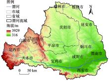
Fig. 1
Geographical location of the study area"

Tab. 1
Maximum influence distance and weight of threat factors"
| 威胁因子 | 最大胁迫距离/km | 权重 | 空间衰退类型 |
|---|---|---|---|
| 城镇用地 | 10 | 1.0 | 指数 |
| 农村居民点 | 8 | 0.6 | 指数 |
| 其他建设用地 | 9 | 0.7 | 指数 |
| 耕地 | 4 | 0.6 | 线性 |
| 未利用地 | 6 | 0.5 | 线性 |
Tab. 2
Sensitivity of different land use types to habitat threat factors"
| 土地利用类型 | 生境适宜度 | 胁迫因子敏感度 | ||||
|---|---|---|---|---|---|---|
| 城镇用地 | 农村居民点 | 其他建设用地 | 耕地 | 未利用地 | ||
| 耕地 | 0.3 | 0.8 | 0.6 | 0.7 | 0.0 | 0.4 |
| 林地 | 1.0 | 0.8 | 0.7 | 0.5 | 0.6 | 0.2 |
| 草地 | 0.9 | 0.7 | 0.5 | 0.6 | 0.8 | 0.6 |
| 水域 | 0.7 | 0.7 | 0.6 | 0.7 | 0.5 | 0.4 |
| 建设用地 | 0.0 | 0.0 | 0.0 | 0.0 | 0.0 | 0.1 |
| 未利用地 | 0.5 | 0.6 | 0.5 | 0.5 | 0.6 | 0.0 |
Tab. 3
Description of the driving factors classification of geographic detector"
| 驱动因子 | 分级方法 | 级别 | 级别说明 |
|---|---|---|---|
| 归一化植被指数(NDVI) | 郭帅[ | 1~6 | 1:≤0.2;2:0.2~0.3;3:0.3~0.4;4:0.4~0.5;5:0.5~0.6;6:>0.6 |
| 坡度(SL)/(°) | NaturalBreaks | 1~6 | 1:0~5;2:6~10;3:11~15;4:16~20;5:21~25;6:>25 |
| 海拔(EL)/m | NaturalBreaks | 1~6 | 通过ArcGIS 10.2的Arc Toolbox/Spatial Analyst Tools/Reclass工具提取 |
| 气温(TEM)/℃ | NaturalBreaks | 1~5 | 通过ArcGIS 10.2的Arc Toolbox/Spatial Analyst Tools/Reclass工具提取 |
| 降水(PRE)/mm | NaturalBreaks | 1~5 | 通过ArcGIS 10.2的Arc Toolbox/Spatial Analyst Tools/Reclass工具提取 |
| 土地利用类型(LUT) | 程静[ | 1~6 | 通过ArcGIS 10.2的Arc Toolbox/Spatial Analyst Tools/Reclass工具提取 |
| 土地利用程度(LUD) | NaturalBreaks | 1~5 | 通过ArcGIS 10.2的Arc Toolbox/Spatial Analyst Tools/Reclass工具提取 |
| 人口密度(POP)/人·km-2 | 葛美玲[ | 1~5 | 1:0~60;2:61~150;3:151~300;4:301~500;5:>500 |
| 地区生产总值(GDP)/元 | NaturalBreaks | 1~5 | 通过ArcGIS 10.2的Arc Toolbox/Spatial Analyst Tools/Reclass工具提取 |
Tab. 4
Changes of habitat quality areas and proportions of different grades in the Weihe River Basin"
| 生境质量等级 | 2000年 | 2010年 | 2020年 | |||||
|---|---|---|---|---|---|---|---|---|
| 面积/km2 | 占比/% | 面积/km2 | 占比/% | 面积/km2 | 占比/% | |||
| 低等 | 3879.74 | 2.89 | 4660.38 | 3.47 | 5388.63 | 4.02 | ||
| 中等 | 58799.54 | 43.81 | 55990.10 | 41.72 | 54379.37 | 40.52 | ||
| 良好 | 2838.23 | 2.12 | 2483.82 | 1.85 | 2460.84 | 1.83 | ||
| 高等 | 68688.38 | 51.18 | 71071.59 | 52.96 | 71977.05 | 53.63 | ||
| 生境质量平均值 | 0.607 | 0.619 | 0.624 | |||||
Fig. 2
Spatial distribution patterns of habitat quality in the Weihe River Basin from 2000 to 2020"
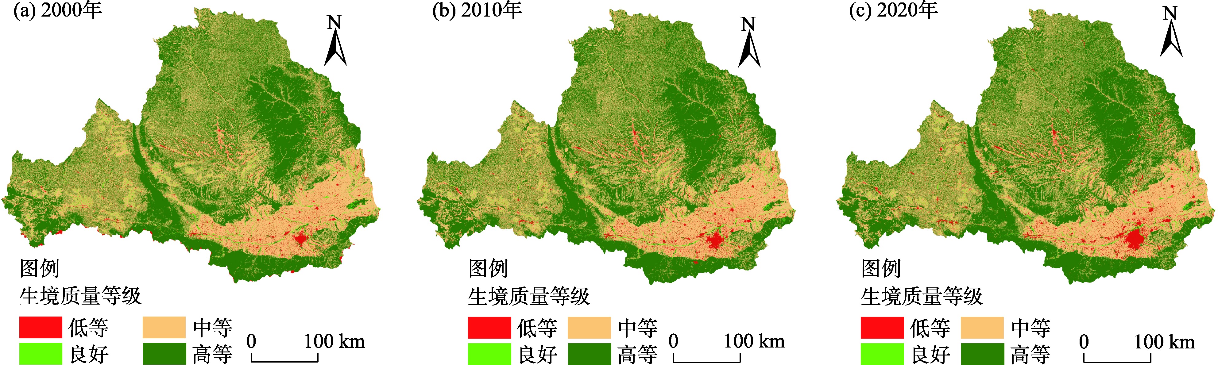
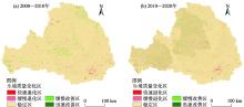
Fig. 3
Spatial changes of habitat quality in the Weihe River Basin from 2000 to 2020"

Tab. 5
Changes of habitat quality areas and proportions in the Weihe River Basin from 2000 to 2020"
| 类型 | 2000—2010年 | 2010—2020年 | |||
|---|---|---|---|---|---|
| 面积/km2 | 占比/% | 面积/km2 | 占比/% | ||
| 快速退化型 | 348.07 | 0.26 | 994.03 | 0.74 | |
| 缓慢退化型 | 2581.92 | 1.92 | 7207.75 | 5.37 | |
| 稳定型 | 127360.19 | 94.89 | 117630.79 | 87.65 | |
| 缓慢改善型 | 3221.43 | 2.41 | 7415.45 | 5.53 | |
| 快速改善型 | 694.28 | 0.52 | 957.87 | 0.71 | |
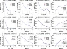
Fig. 4
Terrain gradient distribution characteristics of habitat quality in the Weihe River Basin from 2000 to 2020"
Tab. 6
Detection values of influencing factors of spatial differentiation of habitat quality"
| 影响因素 | 归一化植被指数 (NDVI) | 降水 (PRE) | 气温 (TEM) | 坡度 (SL) | 海拔 (EL) | 土地利用类型 (LUT) | 土地利用程度 (LUD) | 人口密度 (POP) | 地区生产总值 (GDP) |
|---|---|---|---|---|---|---|---|---|---|
| q值 | 0.37 | 0.43 | 0.41 | 0.29 | 0.36 | 0.49 | 0.32 | 0.21 | 0.24 |
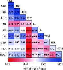
Fig. 5
Interaction of influencing factors of spatially differentiation characteristics of habitat quality"

| [1] |
Terrado M, Sabater S, Kramer B C, et al. Model development for the assessment of terrestrial and aquatic habitat quality in conservation planning[J]. Science of the Total Environment, 2015, 540: 63-70.
doi: 10.1016/j.scitotenv.2015.03.064 |
| [2] |
Hillard E M, Nielsen C K, Groninger J W. Swamp rabbits as indicators of wildlife habitat quality in bottom land hardwood forest ecosystems[J]. Ecological Indicators, 2017, 79: 47-53, doi: 10.1016/j.ecolind.2017.03.024.
doi: 10.1016/j.ecolind.2017.03.024 |
| [3] | 刘园, 周勇, 杜越天. 基于InVEST模型的长江中游经济带生境质量的时空分异特征及其地形梯度效应[J]. 长江流域资源与环境, 2019, 28(10): 2429-2440. |
| [ Liu Yuan, Zhou Yong, Du Yuetian. Study on the spatio-temporal patterns of habitat quality and its terrain gradient effects of the middle of the Yangtze River economic belt based on InVEST Model[J]. Resources and Environment in the Yangtze Basin, 2019, 28(10): 2429-2440. ] | |
| [4] |
赵雪雁, 马平易, 李文青, 等. 黄土高原生态系统服务供需关系的时空变化[J]. 地理学报, 2021, 76(11): 2780-2796.
doi: 10.11821/dlxb202111013 |
|
[ Zhao Xueyan, Ma Pingyi, Li Wenqing, et al. Spatiotemporal changes of supply and demand relationships of ecosystem services in the Loess Plateau[J]. Acta Geographica Sinica, 2021, 76(11): 2780-2796. ]
doi: 10.11821/dlxb202111013 |
|
| [5] | 钟莉娜, 王军. 基于InVEST模型评估土地整治对生境质量的影响[J]. 农业工程学报, 2017, 33(1): 250-255. |
| [ Zhong Lina, Wang Jun. Evaluation on effect of land consolidation on habitat quality based on InVEST model[J]. Transactions of the Chinese Society of Agricultural Engineering, 2017, 33(1): 250-255. ] | |
| [6] |
张学儒, 周杰, 李梦梅. 基于土地利用格局重建的区域生境质量时空变化分析[J]. 地理学报, 2020, 75(1): 160-178.
doi: 10.11821/dlxb202001012 |
|
[ Zhang Xueru, Zhou Jie, Li Mengmei. Analysis on spatial and temporal changes of regional habitat quality based on the spatial pattern reconstruction of land use[J]. Acta Geographica Sinica, 2020, 75(1): 160-178. ]
doi: 10.11821/dlxb202001012 |
|
| [7] |
Li Q, Zhou Y, Mary A C, et al. Spatio-temporal changes in wildlife habitat quality in the middle and lower reaches of the Yangtze River from 1980 to 2100 based on the InVEST model[J]. Journal of Resources and Ecology, 2021, 12: 43-55.
doi: 10.5814/j.issn.1674-764x.2021.01.005 |
| [8] | 陈淼, 苏晓磊, 黄慧敏, 等. 三峡库区河流生境质量评价[J]. 生态学报, 2019, 39(1): 192-201. |
| [ Chen Miao, Su Xiaolei, Huang Huimin, et al. Assessment of river habitat quality in the Three Gorges Reservoir Region[J]. Acta Ecologica Sinica, 2019, 39(1): 192-201. ] | |
| [9] |
Tang F, Fu M C, Wang L, et al. Land-use change in Changli County, China: Predicting its spatio-temporal evolution in habitat quality[J]. Ecological Indicators, 2020, 117: 106719, doi: 10.1016/j.ecolind.2020.106719.
doi: 10.1016/j.ecolind.2020.106719 |
| [10] | 朱增云, 阿里木江·卡斯木. 基于地理探测器的伊犁谷地生境质量时空演变及其影响因素[J]. 生态学杂志, 2020, 39(10): 3408-3420. |
| [ Zhu Zengyun, Kasimu Alimujiang. Spatial-temporal evolution of habitat quality in Yili Valley based on geographical detector and its influencing factors[J]. Chinese Journal of Ecology, 2020, 39(10): 3408-3420. ] | |
| [11] | 贾磊, 姚顺波, 邓元杰, 等. 2000—2020年陕西秦巴山区生境质量时空演变及其地形梯度效应[J]. 长江流域资源与环境, 2022, 31(2): 398-413. |
| [ Jia Lei, Yao Shunbo, Deng Yuanjie, et al. Temporal and spatial evolution of habitat quality and its topographic gradient effect in Qinling-Daba Mountain area, Shaanxi Province, 2000—2020[J]. Resources and Environment in the Yangtze Basin, 2022, 31(2): 398-413. ] | |
| [12] | 王军, 严有龙, 王金满, 等. 闽江流域生境质量时空演变特征与预测研究[J]. 生态学报, 2021, 41(14): 5837-5848. |
| [ Wang Jun, Yan Youlong, Wang Jinman, et al. Temporal-spatial variation characteristics and prediction of habitat quality in Min River Basin[J]. Acta Ecologica Sinica, 2021, 41(14): 5837-5848. ] | |
| [13] | 高庆彦, 潘玉君, 刘化. 基于InVEST模型的大理州生境质量时空演化研究[J]. 生态与农村环境学报, 2021, 37(3): 402-408. |
| [ Gao Qingyan, Pan Yujun, Liu Hua. Spatial-temporal evolution of habitat quality in the Dali Bai Autonomous Prefecture based on the InVEST model[J]. Journal of Ecology and Rural Environment, 2021, 37(3): 402-408. ] | |
| [14] |
白立敏, 冯兴华, 孙瑞丰, 等. 生境质量对城镇化的时空响应——以长春市为例[J]. 应用生态学报, 2020, 31(4): 1267-1277.
doi: 10.13287/j.1001-9332.202004.012 |
|
[ Bai Limin, Feng Xinghua, Sun Ruifeng, et al. Spatial and temporal responses of habitat quality to urbanization: A case study of Changchun City, Jilin Province, China[J]. Chinese Journal of Applied Ecology, 2020, 31(4): 1267-1277. ]
doi: 10.13287/j.1001-9332.202004.012 |
|
| [15] | 常玉旸, 高阳, 谢臻, 等. 京津冀地区生境质量与景观格局演变及关联性[J]. 中国环境科学, 2021, 41(2): 848-859. |
| [ Chang Yuyang, Gao Yang, Xie Zhen, et al. Spatiotemporal evolution and spatial correlation of habitat quality and landscape pattern over Beijing-Tianjin-Hebei region[J]. China Environmental Science, 2021, 41(2): 848-859. ] | |
| [16] | 徐彩仙, 巩杰, 李焱, 等. 基于地形梯度的甘肃白龙江流域典型生态系统服务分布特征[J]. 生态学报, 2020, 40(13): 4291-4301. |
| [ Xu Caixian, Gong Jie, Li Yan, et al. Spatial distribution characteristics of typical ecosystem services based on terrain gradients of Bailongjiang watershed in Gansu[J]. Acta Ecologica Sinica, 2020, 40(13): 4291-4301. ] | |
| [17] |
徐省超, 赵雪雁, 宋晓谕. 退耕还林(草)工程对渭河流域生态系统服务的影响[J]. 应用生态学报, 2021, 32(11): 3893-3904.
doi: 10.13287/j.1001-9332.202111.005 |
|
[ Xu Xingchao, Zhao Xueyan, Song Xiaoyu. Impacts of the returning farmland to forest (grassland) project on ecosystem services in the Weihe River Basin, China[J]. Chinese Journal of Applied Ecology, 2021, 32(11): 3893-3904. ]
doi: 10.13287/j.1001-9332.202111.005 |
|
| [18] |
Yan H M, Liu F, Liu J Y, et al. Status of land use intensity in China and its impacts on land carrying capacity[J]. Journal of Geographical Sciences, 2017, 27(4): 387-402.
doi: 10.1007/s11442-017-1383-7 |
| [19] | 石小伟, 冯广京, 苏培添, 等. 大都市郊区土地利用时空演变特征与生境质量评价[J]. 农业工程学报, 2021, 37(4): 275-284. |
| [ Shi Xiaowei, Feng Guangjing, Su Peitian, et al. Spatiotemporal evolution of land use and habitat quality assessment in the suburbs of metropolitan[J]. Transactions of the Chinese Society of Agricultural Engineering, 2021, 37(4): 275-284. ] | |
| [20] |
张学儒, 周杰, 李梦梅. 基于土地利用格局重建的区域生境质量时空变化分析[J]. 地理学报, 2020, 75(1): 160-178.
doi: 10.11821/dlxb202001012 |
|
[ Zhang Xueru, Zhou Jie, Li Mengmei. Analysis on spatial and temporal changes of regional habitat quality based on the spatial pattern reconstruction of land use[J]. Acta Geographica Sinica, 2020, 75(1): 160-178. ]
doi: 10.11821/dlxb202001012 |
|
| [21] | 赵益祯, 曹建农, 张晓栋, 等. 宝塔区土地利用的地形梯度效应与空间格局[J]. 干旱区地理, 2020, 43(5): 1307-1315. |
| [ Zhao Yizhen, Cao Jiannong, Zhang Xiaodong, et al. Topographic gradient effect and spatial pattern of land use in Baota district[J]. Arid Land Geography, 2020, 43(5): 1307-1315. ] | |
| [22] | 周启刚, 陈丹. 重庆山地都市区土地利用地形特征分异研究[J]. 水土保持研究, 2013, 20(3): 86-91. |
| [ Zhou Qigang, Chen Dan. Researched on the topographic differentiation of land use in Chongqing mountainous metropolitan area[J]. Research of Soil and Water Conservation, 2013, 20(3): 86-91. ] | |
| [23] |
宋戈, 王盼盼. 松嫩高平原县域土地利用空间格局地形梯度特征分析——以巴彦县为例[J]. 地理科学, 2017, 37(8): 1218-1225.
doi: 10.13249/j.cnki.sgs.2017.08.012 |
|
[ Song Ge, Wang Panpan. Spatial pattern of land use along the terrain gradient of county in Songnen High Plain: A case study of Bayan County[J]. Scientia Geographica Sinica, 2017, 37(8): 1218-1225. ]
doi: 10.13249/j.cnki.sgs.2017.08.012 |
|
| [24] |
王劲峰, 徐成东. 地理探测器: 原理与展望[J]. 地理学报, 2017, 72(1): 116-134.
doi: 10.11821/dlxb201701010 |
|
[ Wang Jinfeng, Xu Chengdong. Geodetector: Principle and prospective[J]. Acta Geographica Sinica, 2017, 72(1): 116-134. ]
doi: 10.11821/dlxb201701010 |
|
| [25] | 王鹏, 王亚娟, 刘小鹏, 等. 基于景观结构的生态移民安置区生态风险评价——以宁夏红寺堡区为例[J]. 生态学报, 2018, 38(8): 2672-2682. |
| [ Wang Peng, Wang Yajuan, Liu Xiaopeng, et al. Ecological risk assessment of an ecological migrant resettlement region based on landscape structure: A case study of Hongsibu in Ningxia[J]. Acta Ecologica Sinica, 2018, 38(8): 2672-2682. ] | |
| [26] | 郭帅, 裴艳茜, 胡胜, 等. 黄河流域植被指数对气候变化的响应及其与水沙变化的关系[J]. 水土保持通报, 2020, 40(3): 1-7. |
| [ Guo Shuai, Pei Yanqian, Hu Sheng, et al. Response of vegetation index to climate change and their relationship with runoff-sediment change in Yellow River Basin[J]. Bulletin of Soil and Water Conservation, 2020, 40(3): 1-7. ] | |
| [27] | 程静, 王鹏, 陈红翔, 等. 半干旱区生态风险时空演变及其影响因素的地理探测——以宁夏盐池县为例[J]. 干旱区地理, 2022, 45(5): 1637-1648. |
| [ Cheng Jing, Wang Peng, Chen Hongxiang, et al. Geographical exploration of the spatial and temporal evolution of ecological risk and its influencing factors in semi-arid regions[J]. Arid Land Geography, 2022, 45(5): 1637-1648. ] | |
| [28] |
葛美玲, 封志明. 中国人口分布的密度分级与重心曲线特征分析[J]. 地理学报, 2009, 64(2): 202-210.
doi: 10.11821/xb200902007 |
|
[ Ge Meiling, Feng Zhiming. Population distribution of China based on GIS: Classification of population densities and curve of population gravity centers[J]. Acta Geographica Sinica, 2009, 64(2): 202-210. ]
doi: 10.11821/xb200902007 |
|
| [29] | 李子, 张艳芳. 基于InVEST模型的渭河流域干支流生态系统服务时空演变特征分析[J]. 水土保持学报, 2021, 35(4): 178-185. |
| [ Li Zi, Zhang Yanfang. Spatiotemporal evolution of ecosystem services in the main and tributaries of Weihe River Basin based on InVEST model[J]. Journal of Soil and Water Conservation, 2021, 35(4): 178-185. ] | |
| [30] |
黄鑫, 程文仕, 李晓丹, 等. 甘肃省生境质量变化的图谱特征[J]. 应用生态学报, 2020, 31(9): 3131-3140.
doi: 10.13287/j.1001-9332.202009.015 |
|
[ Huang Xin, Cheng Wenshi, Li Xiaodan, et al. Spectrum characteristics of habitat quality changes in Gansu Province, China[J]. Chinese Journal of Applied Ecology, 2020, 31(9): 3131-3140. ]
doi: 10.13287/j.1001-9332.202009.015 |
|
| [31] |
Ma L B, Bo J, Li X Y, et al. Identifying key landscape pattern indices influencing the ecological security of inland river basin: The middle and lower reaches of Shule River Basin as an example[J]. Science of the Total Environment, 2019, 674: 424-438.
doi: 10.1016/j.scitotenv.2019.04.107 |
| [32] |
Yang W, Jin Y W, Sun T, et al. Trade-offs among ecosystem services in coastal wetlands under the effects of reclamation activities[J]. Ecological Indicators, 2017, 92: 354-366.
doi: 10.1016/j.ecolind.2017.05.005 |
| [33] |
Brumm K J, Jonas J L, Prichard C G, et al. Land cover influences on juvenile rainbow trout diet composition and condition in Lake Michigan tributaries[J]. Ecology of Freshwater Fish, 2019, 28: 11-19.
doi: 10.1111/eff.12422 |
| [34] |
Li M Y, Zhou Y, Xiao P N, et al. Evolution of habitat quality and its topographic gradient effect in northwest Hubei Province from 2000 to 2020 based on the InVEST Model[J]. Land, 2021, 10(8): 857-882.
doi: 10.3390/land10080857 |
| [35] |
杨锁华, 胡守庚, 瞿诗进. 长江中游地区生态系统服务价值的地形梯度效应[J]. 应用生态学报, 2018, 29(3): 976-986.
doi: 10.13287/j.1001-9332.201803.016 |
|
[ Yang Suohua, Hu Shougeng, Qu Shijin. Terrain gradient effect of ecosystem service value in middle reach of Yangtze River, China[J]. Chinese Journal of Applied Ecology, 2018, 29(3): 976-986. ]
doi: 10.13287/j.1001-9332.201803.016 |
|
||