Arid Land Geography ›› 2021, Vol. 44 ›› Issue (4): 1070-1082.doi: 10.12118/j.issn.1000–6060.2021.04.19
• Earth Information Sciences • Previous Articles Next Articles
ZHOU Xuande1( ),GUO Huadong2,YANG Shengtian3,Zibibula SIMAYI3(),DENG Zutao1,LIANG Bin1
Received:2020-04-24
Revised:2021-02-23
Online:2021-07-25
Published:2021-08-02
Contact:
SIMAYI Zibibula
E-mail:zxd850706@163.com;zibibulla3283@sina.cn
ZHOU Xuande,GUO Huadong,YANG Shengtian,Zibibula SIMAYI,DENG Zutao,LIANG Bin. Temporal and spatial variation characteristics of oasis urban ecological environment in arid region: A case study of Karamay City[J].Arid Land Geography, 2021, 44(4): 1070-1082.
Tab. 1
Eigenvalues of principal components"
| 主成分 | 2001年 | 2006年 | 2011年 | 2016年 | ||||
|---|---|---|---|---|---|---|---|---|
| 特征值 | 贡献率/% | 特征值 | 贡献率/% | 特征值 | 贡献率/% | 特征值 | 贡献率/% | |
| PC1 | 0.0992 | 85.6377 | 0.1047 | 85.7392 | 0.0505 | 85.5012 | 0.0894 | 89.4827 |
| PC2 | 0.0112 | 9.6721 | 0.0139 | 11.3759 | 0.0048 | 8.1922 | 0.0069 | 6.8943 |
| PC3 | 0.0040 | 3.4805 | 0.0026 | 2.1644 | 0.0027 | 4.5911 | 0.0034 | 3.4283 |
| PC4 | 0.0014 | 1.2097 | 0.0009 | 0.7206 | 0.0010 | 1.7155 | 0.0002 | 0.1947 |
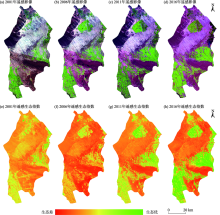
Fig. 1
Remote sensing image (RGB: 543) and spatial distribution of remote sensing ecological index of Karamay district"

Tab. 2
Basic statistic values of remote sensing ecological indices and relative indices"
| 指标 | 2001年 | 2006年 | ||||||
|---|---|---|---|---|---|---|---|---|
| 最小值 | 最大值 | 均值 | 标准差 | 最小值 | 最大值 | 均值 | 标准差 | |
| NDVI | -1.0000 | 0.7604 | 0.1280 | 0.1318 | -1.0000 | 0.7795 | 0.1449 | 0.1582 |
| WET | -0.5470 | 0.0665 | -0.2016 | 0.0614 | -0.5733 | 0.0714 | -0.1785 | 0.0596 |
| LST | 29.3201 | 57.8943 | 47.2234 | 3.3495 | 12.0327 | 38.5387 | 32.3419 | 3.0871 |
| NDBSI | -0.6327 | 1.0000 | 0.1971 | 0.0890 | -0.5184 | 1.0000 | 0.1927 | 0.1156 |
| RSEI | 0.0000 | 1.0000 | 0.3523 | 0.1234 | 0.0000 | 1.0000 | 0.3446 | 0.1256 |
| 指标 | 2011年 | 2016年 | ||||||
| 最小值 | 最大值 | 均值 | 标准差 | 最小值 | 最大值 | 均值 | 标准差 | |
| NDVI | -0.5216 | 1.0000 | 0.1945 | 0.1968 | -0.7725 | 0.8619 | 0.2935 | 0.2601 |
| WET | -0.7883 | 0.1483 | -0.1664 | 0.0692 | -1.3451 | 0.2144 | -0.0472 | 0.0764 |
| LST | 19.9292 | 47.4173 | 36.2315 | 4.5555 | 15.7962 | 46.5827 | 35.8338 | 6.3602 |
| NDBSI | -0.7142 | 1.0000 | 0.1600 | 0.1417 | -0.6426 | 0.5799 | 0.0730 | 0.2099 |
| RSEI | 0.0000 | 1.0000 | 0.3592 | 0.2026 | 0.0000 | 1.0000 | 0.3184 | 0.2579 |

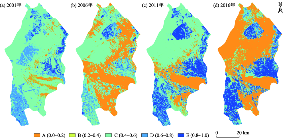
Fig. 2
Spatial distribution of different remote sensing ecological index grades"
Tab. 3
Area percent of different remote sensing ecological index grades"
| RSEI等级 | 2001年 | 2006年 | 2011年 | 2016年 | ||||
|---|---|---|---|---|---|---|---|---|
| 面积/km2 | 占比/% | 面积/km2 | 占比/% | 面积/km2 | 占比/% | 面积/km2 | 占比/% | |
| A | 223.70 | 5.81 | 1547.53 | 40.17 | 656.16 | 17.03 | 2107.60 | 54.71 |
| B | 2637.34 | 68.46 | 1831.28 | 47.54 | 2035.42 | 52.84 | 592.43 | 15.38 |
| C | 830.42 | 21.56 | 401.18 | 10.41 | 485.61 | 12.61 | 382.55 | 9.93 |
| D | 127.42 | 3.31 | 70.19 | 1.82 | 519.34 | 13.48 | 416.90 | 10.82 |
| E | 33.36 | 0.87 | 2.03 | 0.05 | 155.70 | 4.04 | 352.75 | 9.16 |

Fig. 3
Grade change of remote sensing ecological index"

Tab. 4
Grade change of remote sensing ecological index"
| 等级 | 2001—2006年 | 2006—2011年 | 2011—2016年 | 2001—2016年 | ||||
|---|---|---|---|---|---|---|---|---|
| 面积/km2 | 占比/% | 面积/km2 | 占比/% | 面积/km2 | 占比/% | 面积/km2 | 占比/% | |
| -4 | 0.32 | 0.01 | - | - | 0.54 | 0.01 | 0.49 | 0.01 |
| -3 | 6.01 | 0.16 | 0.35 | 0.01 | 13.11 | 0.34 | 3.59 | 0.09 |
| -2 | 85.68 | 2.22 | 5.29 | 0.14 | 82.31 | 2.14 | 212.22 | 5.51 |
| -1 | 1947.11 | 50.55 | 57.60 | 1.50 | 1794.00 | 46.57 | 1920.38 | 49.85 |
| 0 | 1662.55 | 43.16 | 1930.25 | 50.11 | 1312.67 | 34.08 | 797.16 | 20.69 |
| 1 | 126.27 | 3.28 | 1403.79 | 36.44 | 494.87 | 12.85 | 399.94 | 10.38 |
| 2 | 22.81 | 0.59 | 376.10 | 9.76 | 126.26 | 3.28 | 396.98 | 10.31 |
| 3 | 1.46 | 0.04 | 72.90 | 1.89 | 28.09 | 0.73 | 121.34 | 3.15 |
| 4 | 0.01 | 0.00 | 5.96 | 0.15 | 0.37 | 0.01 | 0.12 | 0.00 |
Tab. 5
Variations and dynamic attitudes of different remote sensing ecological index grades"
| RSEI等级 | 2001—2006年 | 2006—2011年 | 2011—2016年 | |||
|---|---|---|---|---|---|---|
| 增加量/km2 | 动态度/% | 增加量/km2 | 动态度/% | 增加量/km2 | 动态度/% | |
| A | 1323.83 | 118.36 | -891.37 | -11.52 | 1451.44 | 44.24 |
| B | -806.06 | -6.11 | 204.14 | 2.23 | -1442.99 | -14.18 |
| C | -429.23 | -10.34 | 84.43 | 4.21 | -103.06 | -4.24 |
| D | -57.22 | -8.98 | 449.15 | 127.97 | -102.44 | -3.95 |
| E | -31.32 | -18.78 | 153.66 | 1510.76 | 197.06 | 25.31 |
Tab. 6
Mean value and niche of different remote sensing ecological index grades"
| RSEI等级 | 2001年 RSEI均值 | 2001—2006年 | 2006年 RSEI均值 | 2006—2011年 | 2011年 RSEI均值 | 2011—2016年 | 2016年 RSEI均值 | |||
|---|---|---|---|---|---|---|---|---|---|---|
| 势 | 生态位 | 势 | 生态位 | 势 | 生态位 | |||||
| A | 0.1778 | -0.0399 | 0.0546 | 0.1379 | 0.0103 | 0.0606 | 0.1482 | -0.0167 | 0.0521 | 0.1315 |
| B | 0.3045 | -0.0349 | 0.1104 | 0.2696 | 0.0016 | 0.1094 | 0.2712 | 0.0062 | 0.1132 | 0.2774 |
| C | 0.4789 | -0.0121 | 0.1952 | 0.4668 | 0.0362 | 0.2056 | 0.5030 | -0.0021 | 0.2033 | 0.5009 |
| D | 0.6914 | -0.0367 | 0.2721 | 0.6547 | 0.0317 | 0.2791 | 0.6864 | 0.0255 | 0.2913 | 0.7119 |
| E | 0.8519 | 0.0190 | 0.3677 | 0.8709 | -0.0116 | 0.3453 | 0.8594 | -0.0186 | 0.3401 | 0.8408 |
Tab. 7
Latitude and longitude coordinates of gravity center of different remote sensing ecological index grades"
| RSEI 等级 | 2001年 | 2006年 | 2011年 | 2016年 | ||||
|---|---|---|---|---|---|---|---|---|
| 经度/E | 纬度/N | 经度/E | 纬度/N | 经度/E | 纬度/N | 经度/E | 纬度/N | |
| A | 85°00′13.51880″ | 45°06′38.45573″ | 84°57′37.04680″ | 45°09′44.24302″ | 84°57′05.06798″ | 45°03′44.26575″ | 84°54′30.91428″ | 45°14′59.11490″ |
| B | 84°54′50.28787″ | 45°13′28.15689″ | 84°52′15.42253″ | 45°13′33.02934″ | 84°53′27.15518″ | 45°16′44.03351″ | 84°54′02.83357″ | 45°10′47.48842″ |
| C | 84°51′25.98427″ | 45°06′06.34960″ | 84°54′52.09637″ | 45°08′19.29840″ | 84°53′53.87569″ | 45°05′18.73948″ | 84°57′39.73842″ | 45°11′42.68208″ |
| D | 85°03′51.65940″ | 45°16′40.94337″ | 84°58′57.01781″ | 45°22′49.77506″ | 84°55′47.51930″ | 45°05′30.36632″ | 84°55′18.64866″ | 45°05′43.32496″ |
| E | 85°05′19.97127″ | 45°18′41.47623″ | 84°44′34.73225″ | 44°57′30.56622″ | 85°02′13.76825″ | 45°18′08.03169″ | 84°54′02.74515″ | 44°59′54.89837″ |
Tab. 8
Gravity offset distance and azimuth angle of different remote sensing ecological index grades"
| RSEI 等级 | 2001—2006年 | 2006—2011年 | 2011—2016年 | |||
|---|---|---|---|---|---|---|
| 偏移距离/km | 方位角/(°) | 偏移距离/km | 方位角/(°) | 偏移距离/km | 方位角/(°) | |
| A | 6.55 | 328.65 | 11.18 | 183.62 | 20.79 | 350.84 |
| B | 3.36 | 270.95 | 6.05 | 14.91 | 11.04 | 175.96 |
| C | 6.08 | 47.74 | 5.72 | 192.84 | 12.83 | 22.54 |
| D | 13.07 | 330.72 | 32.36 | 187.33 | 0.74 | 302.14 |
| E | 47.70 | 214.80 | 44.62 | 31.06 | 35.47 | 197.55 |

Fig. 4
Center shift of different remote sensing ecological index grades"

| [1] | 周亮, 车磊, 孙东琪. 中国城镇化与经济增长的耦合协调发展及影响因素[J]. 经济地理, 2019, 39(6):97-107. |
| [ Zhou Liang, Che Lei, Sun Dongqi. The coupling coordination development between urbanization and economic growth and its influencing factors in China[J]. Economic Geography, 2019, 39(6):97-107. ] | |
| [2] |
崔学刚, 方创琳, 李君, 等. 城镇化与生态环境耦合动态模拟模型研究进展[J]. 地理科学进展, 2019, 38(1):111-125.
doi: 10.18306/dlkxjz.2019.01.010 |
|
[ Cui Xuegang, Fang Chuangling, Li Jun, et al. Progress in dynamic simulation modeling of urbanization and ecological environment coupling[J]. Progress in Geography, 2019, 38(1):111-125. ]
doi: 10.18306/dlkxjz.2019.01.010 |
|
| [3] |
张洪, 李中元, 李彦. 基于生态安全的山地城镇土地可持续利用模式研究——以云南大理市为例[J]. 地理研究, 2019, 38(11):2681-2694.
doi: 10.11821/dlyj020181341 |
|
[ Zhang Hong, Li Zhongyuan, Li Yan. Study on sustainable land use model in mountain towns based on ecological security: Taking Dali City of Yunnan Province as an example[J]. Geographical Research, 2019, 38(11):2681-2694. ]
doi: 10.11821/dlyj020181341 |
|
| [4] | 蒋慧峰. 城镇化与生态环境耦合协调发展研究[J]. 经济研究导刊, 2019(4):157-161. |
| [ Jiang Huifeng. Study on coupling and coordinated development between urbanization and eco-environment[J]. Economic Research Guide, 2019(4):157-161. ] | |
| [5] | 乔标, 方创琳. 城市化与生态环境协调发展的动态耦合模型及其在干旱区的应用[J]. 生态学报, 2005, 25(11):211-217. |
| [ Qiao Biao, Fang Chuangling. The dynamic coupling model of the harmonious development between urbanization and eco-environment and its application in arid area[J]. Acta Ecologica Sinica, 2005, 25(11):211-217. ] | |
| [6] |
陈晓红, 万鲁河. 城市化与生态环境耦合的脆弱性与协调性作用机制研究[J]. 地理科学, 2013, 33(12):1450-1457.
doi: 10.13249/j.cnki.sgs.2013.012.1450 |
|
[ Chen Xiaohong, Wan Luhe. The interactive mechanisms for the coordination and vulnerability between regional urban and eco-environment[J]. Scientia Geographica Sinica, 2013, 33(12):1450-1457. ]
doi: 10.13249/j.cnki.sgs.2013.012.1450 |
|
| [7] | 王少剑, 方创琳, 王洋. 京津冀地区城市化与生态环境交互耦合关系定量测度[J]. 生态学报, 2015, 35(7):2244-2254. |
| [ Wang Shaojian, Fang Chuangling, Wang Yang. Quantitative investigation of the interactive coupling relationship between urbanization and eco-environment[J]. Acta Ecologica Sinica, 2015, 35(7):2244-2254. ] | |
| [8] | 孙东琪, 张京祥, 朱传耿, 等. 中国生态环境质量变化态势及其空间分异分析[J]. 地理学报, 2012, 67(12):1599-1610. |
| [ Sun Dongqi, Zhang Jingxiang, Zhu Chuangeng, et al. An assessment of China’s ecological environment quality change and its spatial variation[J]. Acta Geographica Sinica, 2012, 67(12):1599-1610. ] | |
| [9] | 刘远书, 高文文, 侯坤, 等. 南水北调中线水源区生态环境变化分析研究[J]. 长江流域资源与环境, 2015, 24(3):440-446. |
| [ Liu Yuanshu, Gao Wenwen, Hou Kun, et al. Analysis of ecological environment change on watershed of the middle route of south-north water diversion project[J]. Resources and Environment in the Yangtze Basin, 2015, 24(3):440-446. ] | |
| [10] | 张春桂, 李计英. 基于3S技术的区域生态环境质量监测研究[J]. 自然资源学报, 2010, 25(12):2060-2071. |
| [ Zhang Chungui, Li Jiying. Study of regional eco-environmental quality monitoring based on 3S techniques[J]. Journal of Natural Resources, 2010, 25(12):2060-2071. ] | |
| [11] | 徐涵秋. 城市遥感生态指数的创建及其应用[J]. 生态学报, 2013, 33(24):7853-7862. |
| [ Xu Hanqiu. A remote sensing urban ecological index and its application[J]. Acta Ecologica Sinica, 2013, 33(24):7853-7862. ] | |
| [12] | 吴志杰, 王猛猛, 陈绍杰, 等. 基于遥感生态指数的永定矿区生态变化监测与评价[J]. 生态科学, 2016, 35(5):200-207. |
| [ Wu Zhijie, Wang Mengmeng, Chen Shaojie, et al. Monitoring and evaluation of ecological environment’s spatio-temporal variation in mine based on RSEI in Yongding mine[J]. Ecological Science, 2016, 35(5):200-207. ] | |
| [13] | 宋慧敏, 薛亮. 基于遥感生态指数模型的渭南市生态环境质量动态监测与分析[J]. 应用生态学报, 2016, 27(12):3913-3919. |
| [ Song Huimin, Xue Liang. Dynamic monitoring and analysis of ecological environment in Weinan City, northwest China based on RSEI model[J]. Chinese Journal of Applied Ecology, 2016, 27(12):3913-3919. ] | |
| [14] | 闫正龙, 高凡, 何兵. 3S技术在我国生态环境动态演变研究中的应用进展[J]. 地理信息世界, 2019, 26(2):43-48. |
| [ Yan Zhenglong, Gao Fan, He Bing. Review on the application of 3S technologies in the dynamic evolution of ecological environment at China[J]. Geomatics World, 2019, 26(2):43-48. ] | |
| [15] | 单薇, 金晓斌, 孟宪素, 等. 基于多源遥感数据的土地整治生态环境质量动态监测[J]. 农业工程学报, 2019, 35(1):234-242. |
| [ Shan Wei, Jin Xiaobin, Meng Xiansu, et al. Dynamical monitoring of ecological environment quality of land consolidation based on multi-source remote sensing data[J]. Transactions of the Chinese Society of Agricultural Engineering, 2019, 35(1):234-242. ] | |
| [16] | 顾成林, 周健. 大连市生态环境质量研究[J]. 黑龙江环境通报, 2012, 36(3):37-40. |
| [ Gu Chenglin, Zhou Jian. Research on ecological environment quality of Dalian City[J]. Heilongjiang Environmental Journal, 2012, 36(3):37-40. ] | |
| [17] | 周玄德, 窦文章, 李国栋. 西山煤田生态变化的遥感监测与评价[J]. 中国矿业, 2019, 28(1):108-114, 121. |
| [ Zhou Xuande, Dou Wenzhang, Li Guodong. Remote sensing monitoring and evaluation of the ecological changes in Xishan coalfield[J]. China Mining Magazine, 2019, 28(1):108-114, 121. ] | |
| [18] | 张浩, 杜培军, 罗洁琼, 等. 基于遥感生态指数的南京市生态变化分析[J]. 地理空间信息, 2017, 15(2):58-62. |
| [ Zhang Hao, Du Peijun, Luo Jieqiong, et al. Ecological change analysis of Nanjing City based on remote sensing ecological index[J]. Geospatial Information, 2017, 15(2):58-62. ] | |
| [19] | 刘智才, 徐涵秋, 李乐, 等. 基于遥感生态指数的杭州市城市生态变化[J]. 应用基础与工程科学学报, 2015, 23(4):728-739. |
| [ Liu Zhicai, Xu Hanqiu, Li Le, et al. Ecological change in the Hangzhou area using the remote sensing based ecological index[J]. Journal of Basic Science and Engineering, 2015, 23(4):728-739. ] | |
| [20] | 周玄德, 孜比布拉·司马义, 严姗, 等. 克拉玛依市经济增长与生态环境关系的计量分析[J]. 水土保持通报, 2013, 33(2):236-240. |
| [ Zhou Xuande, Simayi Zibibula, Yan Shan, et al. Econometric analysis on relationship of economic growth and eco-environment in Karamay City[J]. Bulletin of Soil and Water Conservation, 2013, 33(2):236-240. ] | |
| [21] | 方创琳, 杨玉梅. 城市化与生态环境交互耦合系统的基本定律[J]. 干旱区地理, 2006, 29(1):1-8. |
| [ Fang Chuanglin, Yang Yumei. Basic laws of the interactive coupling system of urbanization and ecological environment[J]. Arid Land Geography, 2006, 29(1):1-8. ] | |
| [22] | 雷军, 李建刚, 段祖亮, 等. 喀什城市圈城镇化与生态环境交互胁迫效应研究综述[J]. 干旱区地理, 2018, 41(6):1358-1366. |
| [ Lei Jun, Li Jiangang, Duan Zuliang, et al. Research review on reciprocal coercing effect between urbanization and eco-environment in Kashgar metropolitan, Xinjiang, China[J]. Arid Land Geography, 2018, 41(6):1358-1366. ] | |
| [23] | 张亚如, 张军民. 城镇化与经济发展的时空相互作用机制研究——以新疆为例[J]. 干旱区地理, 2020, 43(3):839-848. |
| [ Zhang Yaru, Zhang Junmin. Spatio-temporal interaction mechanism of urbanization and economic development: A case of Xinjiang[J]. Arid Land Geography, 2020, 43(3):839-848. ] | |
| [24] | 谭华, 智海, 李艳春, 等. 城市化及湖泊湿地修复对银川市气候影响初探[J]. 干旱区地理, 2019, 42(3):509-516. |
| [ Tan Hua, Zhi Hai, Li Yanchun, et al. Influence of urbanization and lake wetland restoration on the climate evolution in Yinchuan City[J]. Arid Land Geography, 2019, 42(3):509-516. ] | |
| [25] | 周亮, 朱彦儒, 孙东琪. 河西走廊城乡居民点空间分异特征及绿洲孕育度分析[J]. 干旱区地理, 2020, 43(1):227-236. |
| [ Zhou Liang, Zhu Yanru, Sun Dongqi. Spatial differentiation characteristics and oasis breed degree of urban and rural residents in Hexi Corridor[J]. Arid Land Geography, 2020, 43(1):227-236. ] | |
| [26] | 徐涵秋. 区域生态环境变化的遥感评价指数[J]. 中国环境科学, 2013, 33(5):889-897. |
| [ Xu Hanqiu. A remote sensing index for assessment of regional ecological changes[J]. China Environmental Science, 2013, 33(5):889-897. ] | |
| [27] | 王俊祺, 潘文斌. 生态环境变化遥感评价指数的应用研究——以敖江流域为例[J]. 环境科学与管理, 2014, 39(12):186-190. |
| [ Wang Junqi, Pan Wenbin. Application of remote ecological changes sensing index in assesing of Aojiang watershed[J]. Environmental Science and Management, 2014, 39(12):186-190. ] | |
| [28] | 牛安逸, 马姣娇, 陈志云. 基于遥感技术及综合指数法的广州市自然生态环境评价[J]. 中国城市林业, 2015, 13(6):11-15, 63. |
| [ Niu Anyi, Ma Jiaojiao, Chen Zhiyun. Natural ecological environment evaluation in Guangzhou based on remote sensing technology and comprehensive index method[J]. Journal of Chinese Urban Forestry, 2015, 13(6):11-15, 63. ] | |
| [29] | 周玄德, 郭华东, 孜比布拉·司马义, 等. 干旱区绿洲城市遥感生态指数变化监测[J]. 资源科学, 2019, 41(5):1002-1012. |
| [ Zhou Xuande, Guo Huadong, Simayi Zibibula, et al. Change of remote sensing ecological index of an oasis city in the arid area[J]. Resources Science, 2019, 41(5):1002-1012. ] | |
| [30] |
Nichol J. Remote sensing of urban heat islands by day and night[J]. Photogrammetric Engineering and Remote Sensing, 2005, 71(6):613-621.
doi: 10.14358/PERS.71.5.613 |
| [31] | 孙倩, 塔西甫拉提·特依拜, 张飞, 等. 渭干河-库车河三角洲绿洲土地利用/覆被时空变化遥感研究[J]. 生态学报, 2012, 32(10):3252-3265. |
| [ Sun Qian, Tiyip Tashpolat, Zhang Fei, et al. Dynamics of land use/cover changes in the Weigan and Kuqa Rivers delta oasis based on remote sensing[J]. Acta Ecologica Sinica, 2012, 32(10):3252-3265. ] | |
| [32] | 彭莹, 严力蛟. 基于生态位理论的浙江省旅游城市竞争发展策略[J]. 生态学报, 2015, 35(7):2195-2205. |
| [ Peng Ying, Yan Lijiao. Competition relationship among tourist cities in Zhejiang Province based on the niche theories[J]. Acta Ecologica Sinica, 2015, 35(7):2195-2205. ] | |
| [33] | 于海洋, 张飞, 王娟, 等. 土地经济生态位在县域景观格局分析中的应用——以新疆精河县为例[J]. 应用生态学报, 2015, 26(12):3849-3857. |
| [ Yu Haiyang, Zhang Fei, Wang Juan, et al. Application of land economic ecological niche in landscape pattern analysis at county level: A case study of Jinghe County in Xinjiang, China[J]. Chinese Journal of Applied Ecology, 2015, 26(12):3849-3857. ] | |
| [34] | 乔慧捷, 胡军华, 黄继红. 生态位模型的理论基础、发展方向与挑战[J]. 中国科学: 生命科学, 2013, 43(11):915-927. |
| [ Qiao Huijie, Hu Junhua, Huang Jihong. Theoretical basis, future directions, and challenges for ecological niche models[J]. Scientia Sinica Vitae, 2013, 43(11):915-927. ] | |
| [35] | 程乾, 方琳. 生态位视角下长三角文化旅游创意产业竞争力评价模型构建及实证[J]. 经济地理, 2015, 35(7):183-189. |
| [ Cheng Qian, Fang Lin. Competitiveness evaluation model and empirical research of cultural tourism creative industry in Yangtze River Delta based on ecological niche[J]. Economic Geography, 2015, 35(7):183-189. ] | |
| [36] | 孟德友, 陆玉麒. 基于生态位理论的城市生态位研究——以河南各省辖市为例[J]. 地域研究与开发, 2008, 27(2):56-59. |
| [ Meng Deyou, Lu Yulin. A quantitative study on the city niche based on the niche theory: A case of cities under the jurisdiction of Henan Province[J]. Areal Research and Development, 2008, 27(2):56-59. ] | |
| [37] | 吴凯, 顾晋饴, 何宏谋, 等. 基于重心模型的丘陵山地区耕地利用转换时空特征研究[J]. 农业工程学报, 2019, 35(7):247-254. |
| [ Wu Kai, Gu Jinyi, He Hongmou, et al. Spatiotemporal characteristics of cultivated land use transition in hilly and mountainous regions based on barycenter model[J]. Transactions of the Chinese Society of Agricultural Engineering, 2019, 35(7):247-254. ] | |
| [38] |
王德怀, 李旭东. 贵州乌江流域人口与经济发展协调性研究[J]. 地理科学, 2019, 39(3):477-486.
doi: 10.13249/j.cnki.sgs.2019.03.014 |
|
[ Wang Dehuai, Li Xudong. Coordination of population and economic development in the Wujiang River Basin of Guizhou Province[J]. Scientia Geographica Sinica, 2019, 39(3):477-486. ]
doi: 10.13249/j.cnki.sgs.2019.03.014 |
|
||