Arid Land Geography ›› 2021, Vol. 44 ›› Issue (4): 1022-1031.doi: 10.12118/j.issn.1000–6060.2021.04.15
• Earth Surface Process • Previous Articles Next Articles
JIA Danyang1,2,3( ),XIONG Zhenzhen1,2,3,GAO Yan1,2,3,ZHANG Jiehua1,2,3,WANG Shuyi1,2,3,ZHAO Yuanjie1,2,3()
Received:2020-03-19
Revised:2020-12-25
Online:2021-07-25
Published:2021-08-02
Contact:
Yuanjie ZHAO
E-mail:15233618939@163.com;ecoenvir@163.com
JIA Danyang,XIONG Zhenzhen,GAO Yan,ZHANG Jiehua,WANG Shuyi,ZHAO Yuanjie. Land use/land cover change and influencing factors in the Taitema Lake in the past 30 years[J].Arid Land Geography, 2021, 44(4): 1022-1031.

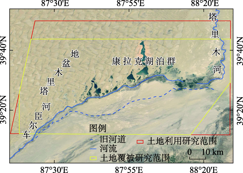
Fig. 1
Sketch map of the study area"
Tab. 1
Area fraction of vegetation cover types in Taitema Lake area from 1988 to 2017"
| 年份 | 草地 | 林地 | 耕地 | |||
|---|---|---|---|---|---|---|
| 面积/km2 | 比例/% | 面积/km2 | 比例/% | 面积/km2 | 比例/% | |
| 1990 | 278.32 | 6.04 | 2.56 | 0.06 | 3.00 | 0.07 |
| 2000 | 442.79 | 9.61 | 11.75 | 0.26 | 36.28 | 0.79 |
| 2010 | 334.91 | 7.27 | 106.50 | 2.31 | - | - |
| 2017 | 275.38 | 5.97 | 5.87 | 0.13 | 0.24 | 0.01 |
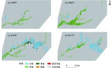
Fig. 2
Map of land use/land cover types in Taitema Lake area from 1988 to 2017"


Fig. 3
Interannual variation of annual maximum NDVI and seasonal NDVI in Taitema Lake area"


Fig. 4
Annual maximum NDVI interannual change of vegetation types in Taitema Lake area from 1988 to 2017"
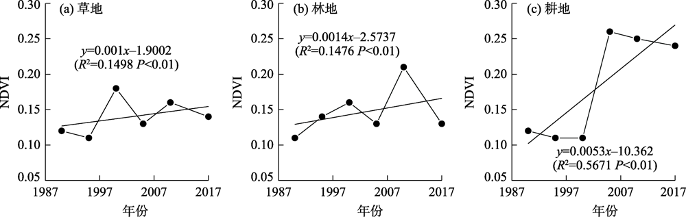

Fig. 5
Spatial distribution of annual maximum NDVI average value of vegetation in the recent 30 years in Taitema Lake area"


Fig. 6
Annual maximum NDVI spatial distribution of vegetation in four key years in Taitema Lake area"
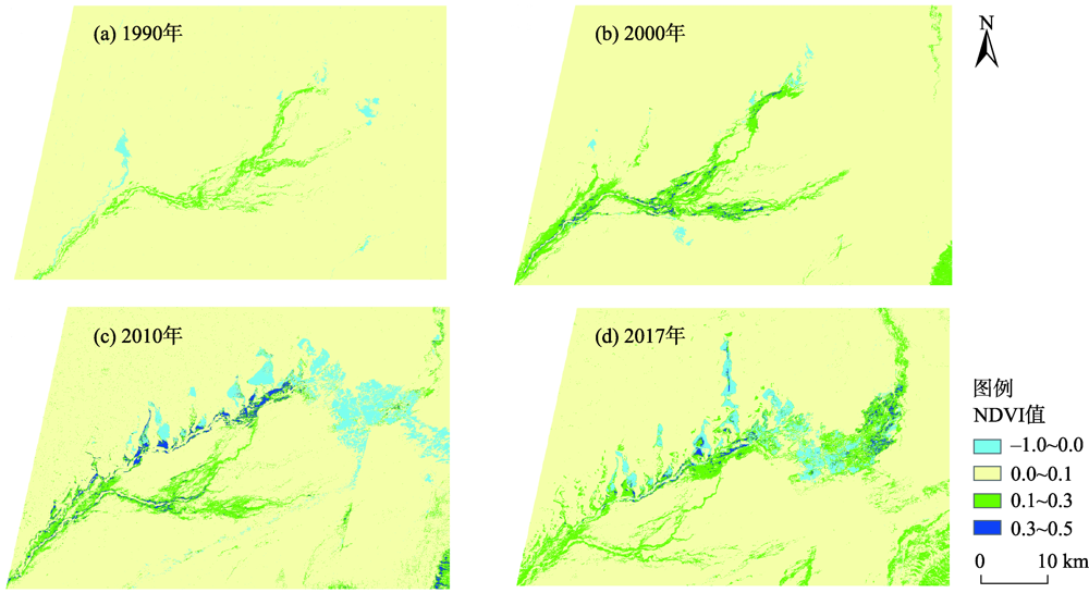

Fig. 7
NDVI change trend of Taitema Lake area from 1988 to 2017"
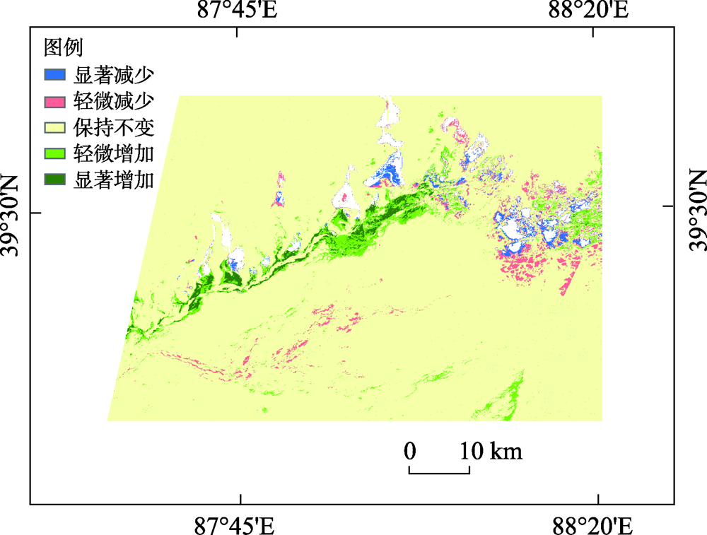
Tab. 2
Change trend of vegetation coverage"
| 指标 | 斜率变化区间 | 面积/km2 | 百分比/% |
|---|---|---|---|
| 显著减少 | <-0.02 | 42.87 | 0.93 |
| 轻微减少 | -0.02~-0.01 | 151.21 | 2.58 |
| 保持不变 | -0.01~0.01 | 4234.28 | 91.85 |
| 轻微增加 | 0.01~0.02 | 118.94 | 3.28 |
| 显著增加 | >0.02 | 62.70 | 1.36 |
Tab. 3
Correlation coefficients between the type structure and annual maximum NDVI and various meteorological elements"
| 植被 | 站点 | 相关系数 | |||||||
|---|---|---|---|---|---|---|---|---|---|
| 年均 | 春季 | 夏季 | 秋季 | 年均 | 春季 | 夏季 | 秋季 | ||
| 气温 | 气温 | 气温 | 气温 | 降水量 | 降水量 | 降水量 | 降水量 | ||
| 年最大NDVI | 若羌 | -0.065 | 0.143 | -0.008 | 0.036 | -0.245 | -0.251 | -0.050 | -0.124 |
| 且末 | 0.403* | 0.276 | 0.506** | 0.477** | 0.012 | 0.057 | -0.057 | 0.047 | |
| 草地 | 若羌 | 0.041 | 0.313 | 0.313 | -0.584 | -0.188 | -0.345 | 0.074 | -0.188 |
| 且末 | 0.398 | 0.448 | 0.384 | 0.179 | 0.717 | -0.242 | 0.822* | 0.111 | |
| 林地 | 若羌 | 0.189 | -0.206 | 0.786 | -0.326 | -0.233 | 0.331 | -0.038 | -0.233 |
| 且末 | 0.047 | -0.266 | 0.471 | 0.051 | 0.517 | 0.077 | 0.214 | 0.774 | |
| 耕地 | 若羌 | -0.290 | -0.166 | 0.269 | 0.101 | 0.510 | 0.311 | 0.592 | 0.510 |
| 且末 | 0.512 | 0.262 | 0.710 | 0.767 | 0.314 | 0.646 | -0.130 | 0.134 | |
| 植被 | 站点 | 相关系数 | |||||||
| 年均 | 春季 | 夏季 | 秋季 | 年均 | 春季 | 夏季 | 秋季 | ||
| 日照时数 | 日照时数 | 日照时数 | 日照时数 | 湿度 | 湿度 | 湿度 | 湿度 | ||
| 年最大NDVI | 若羌 | -0.064 | 0.197 | -0.316 | -0.117 | 0.298 | -0.024 | 0.248 | 0.381* |
| 且末 | 0.300 | 0.291 | 0.051 | -0.017 | -0.439* | -0.389* | -0.494** | -0.277 | |
| 草地 | 若羌 | -0.622 | -0.244 | -0.398 | -0.518 | 0.103 | -0.061 | 0.400 | 0.047 |
| 且末 | 0.135 | 0.472 | 0.021 | 0.018 | 0.013 | -0.239 | 0.683 | -0.090 | |
| 林地 | 若羌 | -0.804 | -0.559 | -0.221 | -0.680 | 0.101 | -0.072 | -0.038 | 0.508 |
| 且末 | -0.484 | -0.228 | -0.731 | -0.366 | 0.278 | 0.058 | 0.395 | 0.290 | |
| 耕地 | 若羌 | -0.628 | -0.590 | -0.767 | 0.228 | 0.234 | 0.076 | 0.341 | 0.401 |
| 且末 | 0.424 | 0.360 | -0.110 | -0.504 | -0.489 | -0.055 | -0.327 | -0.558 | |
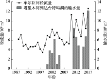
Fig. 8
Change of Qarqan River runoff and water conveyance from Tarim River"

Tab. 4
Principal component analysis of influencing factors of annual maximum NDVI"
| 时段 | 主成分 | β1 | β2 | β3 | β4 | β5 | β6 | β7 | β8 | β9 | β10 | β11 | β12 | 特征根 | 方差贡献率/% | 累计贡献率/% |
|---|---|---|---|---|---|---|---|---|---|---|---|---|---|---|---|---|
| 输 水 前 时 段 | P1 | 0.845 | -0.709 | 0.377 | 0.141 | 0.809 | 0.422 | 0.820 | 0.052 | 0.435 | -0.344 | -0.695 | - | 3.678 | 33.437 | 33.437 |
| P2 | 0.386 | 0.211 | 0.650 | -0.852 | -0.170 | 0.473 | 0.439 | -0.455 | -0.766 | 0.622 | 0.220 | - | 3.014 | 27.400 | 60.836 | |
| P3 | 0.142 | 0.599 | -0.217 | -0.085 | 0.198 | 0.487 | 0.154 | 0.386 | -0.084 | -0.565 | 0.389 | - | 1.361 | 12.368 | 73.205 | |
| P4 | 0.258 | 0.147 | 0.107 | -0.089 | -0.356 | -0.317 | 0.217 | 0.775 | 0.064 | 0.254 | -0.176 | - | 1.081 | 9.827 | 83.031 | |
| 输 水 后 时 段 | P5 | 0.575 | -0.249 | 0.272 | -0.617 | 0.888 | 0.785 | -0.591 | -0.369 | 0.626 | 0.073 | 0.822 | 0.834 | 4.508 | 37.565 | 37.565 |
| P6 | -0.579 | 0.064 | 0.832 | -0.440 | 0.157 | 0.039 | -0.338 | 0.457 | -0.654 | 0.818 | -0.101 | 0.099 | 2.692 | 22.437 | 60.002 | |
| P7 | -0.205 | 0.793 | 0.170 | 0.351 | -0.152 | 0.136 | -0.450 | 0.438 | 0.256 | -0.417 | 0.074 | 0.261 | 1.571 | 13.089 | 73.091 | |
| P8 | 0.409 | 0.259 | 0.195 | -0.337 | 0.272 | 0.166 | 0.545 | 0.476 | 0.003 | -0.202 | -0.142 | -0.211 | 1.116 | 9.301 | 82.393 |
| [1] | 刘纪远, 匡文慧, 张增祥, 等. 20世纪80年代末以来中国土地利用变化的基本特征与空间格局[J]. 地理学报, 2014, 69(1):3-14. |
| [ Liu Jiyuan, Kuang Wenhui, Zhang Zengxiang, et al. Spatio-temporal characteristics, patterns and causes of land use changes in China since the late 1980s[J]. Acta Geographica Sinica, 2014, 69(1):3-14. ] | |
| [2] | 王姝怡. 近30a台特玛湖地区生态环境演变及影响因素研究[D]. 石家庄: 河北师范大学, 2019. |
| [ Wang Shuyi. Study on the evolution and driving factors of ecological environment in the Taitema Lake area in recent 30 years[D]. Shijiazhuang: Hebei Normal University, 2019. ] | |
| [3] | 周梦甜, 李军, 朱康文. 近15 a 新疆不同类型植被NDVI时空动态变化及对气候变化的响应[J]. 干旱区地理, 2015, 38(4):779-787. |
| [ Zhou Mengtian, Li Jun, Zhu Kangwen. Spatial-temporal dynamics of different types of vegetation NDVI and its response to climate change in Xinjiang during 1998—2012[J]. Arid Land Geography, 2015, 38(4):779-787. ] | |
| [4] | 武正丽, 贾文雄, 赵珍, 等. 2000—2012年祁连山植被覆盖变化及其与气候因子的相关性[J]. 干旱区地理, 2015, 38(6):1241-1252. |
| [ Wu Zhengli, Jia Wenxiong, Zhao Zhen, et al. Spatial-temporal variations of vegetation and its correlation with climatic factors in Qilian Mountains from 2000 to 2012[J]. Arid Land Geography, 2015, 38(6):1241-1252. ] | |
| [5] | 刘少华, 严登华, 史晓亮, 等. 中国植被NDVI与气候因子的年际变化及相关性研究[J]. 干旱区地理, 2014, 37(3):480-489. |
| [ Liu Shaohua, Yan Denghua, Shi Xiaoliang, et al. Inter-annual variability of vegetation NDVI, accumulated temperature and precipitation and their correlations in China[J]. Arid Land Geography, 2014, 37(3):480-489. ] | |
| [6] | 赵鸿雁, 陈英, 周翼, 等. 甘肃中东部植被生长季NDVI时空变化及其对气候因子的响应[J]. 干旱区地理, 2019, 42(6):1427-1435. |
| [ Zhao Hongyan, Chen Ying, Zhou Yi, et al. Spatiotemporal variation of NDVI in vegetation growing season and its responses to climatic factors in mid and eastern Gansu Province from 2008 to 2016[J]. Arid Land Geography, 2019, 42(6):1427-1435. ] | |
| [7] | 刘成林, 樊任华, 武建军, 等. 锡林郭勒草原植被生长对降水响应的滞后性研究[J]. 干旱区地理, 2009, 32(4):512-518. |
| [ Liu Chenglin, Fan Renhua, Wu Jianjun, et al. Temporal lag of grassland vegetation growth response to precipitation in Xilinguolemeng[J]. Arid Land Geography, 2009, 32(4):512-518. ] | |
| [8] | 毕超. 基于多源数据的中国干旱半干旱区植被覆盖与物候对气候变化的响应[D]. 北京: 北京林业大学, 2015. |
| [ Bi Chao. Dynamics of vegetation and phenology and their response to climate change based on multi-source data in the arid and semiarid region, China[D]. Beijing: Beijing Forestry University, 2015. ] | |
| [9] | 李晓兵, 陈云浩, 张云霞, 等. 气候变化对中国北方荒漠草原植被的影响[J]. 地球科学进展, 2002(2):254-261. |
| [ Li Xiaobing, Chen Yunhao, Zhang Yunxia, et al. Impact of climate change on desert steppe in northern China[J]. Advances in Earth Science, 2002(2):254-261. ] | |
| [10] | 郭继凯. 塔里木河流域植被覆盖对气候变化和人类活动的响应[D]. 北京: 北京林业大学, 2016. |
| [ Guo Jikai. Responses of vegetation coverage to climate change and human activities in the Tarim River Basin[D]. Beijing: Beijing Forestry University, 2016. ] | |
| [11] | 王雅梅, 张青青, 徐海量, 等. 生态输水前后台特玛湖植物多样性变化特征[J]. 干旱区研究, 2019, 36(5):1186-1193. |
| [ Wang Yamei, Zhang Qingqing, Xu Hailiang, et al. Change of plant diversity in the Taitema Lake area before and after implementing the ecological water conveyance[J]. Arid Zone Research, 2019, 36(5):1186-1193. ] | |
| [12] | 樊自立, 徐海量, 傅荩仪, 等. 台特玛湖湿地保护研究[J]. 第四纪研究, 2013, 33(3):594-602. |
| [ Fan Zili, Xu Hailiang, Fu Jinyi, et al. Study on protection of wetland of Taitema Lake[J]. Quaternary Sciences, 2013, 33(3):594-602. ] | |
| [13] | 马明国, 宋怡, 王雪梅. 1973—2006年新疆若羌湖泊群遥感动态监测研究[J]. 冰川冻土, 2008, 30(2):189-195. |
| [ Ma Mingguo, Song Yi, Wang Xuemei. Dynamically monitoring the lake group in Ruoqiang County, Xinjiang region[J]. Journal of Glaciology and Geocryology, 2008, 30(2):189-195. ] | |
| [14] | 朱刚, 高会军, 曾光, 等. 西北内陆干旱区河流绿色走廊湿地景观格局变化及其生态效应研究——以车尔臣河下游为例[J]. 国土资源遥感, 2010(86):219-223. |
| [ Zhu Gang, Gao Huijun, Zeng Guang, et al. Variation of wetland landscape pattern and its ecological effects in the green corridor of the arid inland in northwest China: A case study of the lower reaches of the Qarqan River[J]. Remote Sensing for Land and Resources, 2010(86):219-223. ] | |
| [15] | 蔡东旭, 李生宇, 刘耀中, 等. 台特玛湖干涸湖盆区植物风影沙丘的形态特征[J]. 干旱区地理, 2017, 40(5):1020-1028. |
| [ Cai Dongxu, Li Shengyu, Liu Yaozhong, et al. Morphological characteristics of shadow dunes of plant at dry lake bed of Taitema Lake[J]. Arid Land Geography, 2017, 40(5):1020-1028. ] | |
| [16] | 陈国亮. 台特玛湖湖面面积与主要补给水源的关系分析[J]. 水利科技与经济, 2016, 22(7):41-44. |
| [ Chen Guoliang. Analysis on the relationship between lake surface area and main recharge water sources in Taitema Lake[J]. Water Science and Technology and Economy, 2016, 22(7):41-44. ] | |
| [17] | 邓少福. 祁连山气候变化对植被的影响研究(2000—2011)[D]. 兰州: 兰州大学, 2013. |
| [ Deng Shaofu. Impacts of climate change on vegetation in Qilian Mountains from 2000 to 2011[D]. Lanzhou: Lanzhou University, 2013. ] | |
| [18] | 赵霞, 谭琨, 方精云. 1982—2006年新疆植被活动的年际变化及其季节差异[J]. 干旱区研究, 2011, 28(1):10-16. |
| [ Zhao Xia, Tan Kun, Fang Jingyun. NDVI-based interannual and seasonal variations of vegetation activity in Xinjiang during the period of 1982—2006[J]. Arid Zone Research, 2011, 28(1):10-16. ] | |
| [19] | 杨玲, 瓦哈甫·哈力克, 穆艾塔尔·赛地. 近50a来气候变化和人类活动对且末县水资源的影响[J]. 农业系统科学与综合研究, 2010, 26(1):1-5. |
| [ Yang Ling, Halik Wahap, Saydi Muattar. The impact of climate change and anthropogenic activities on water resources variation during the past 50 years in Qerchen[J]. System Sciences and Comprehensive Studies in Agriculture, 2010, 26(1):1-5. ] | |
| [20] | 迪力夏提·阿卜杜萨拉木, 阿不都克依木·阿布力孜, 周玄德, 等. 干旱区典型绿洲耕地扩张及其人文驱动研究——以新疆且末绿洲为例[J]. 地域研究与开发, 2015, 34(2):131-136, 176. |
| [ Abdusalamu Dilixiati, Abulizi Abdukyimu, Zhou Xuande, et al. A study on the expansion of cultivated land in a typical oasis in arid areas and its humanistic drive: Taking Xinjiang Qiemo Oasis as an example[J]. Regional Research and Development, 2015, 34(2):131-136, 176. ] | |
| [21] | 张帅, 汪洋, 夏婷婷, 等. 塔里木河生态输水条件下土地利用/覆被变化对生态系统服务价值的影响[J]. 干旱区地理, 2021, 44(3):739-749. |
| [ Zhang Shuai, Wang Yang, Xia Tingting, et al. Effects of land use/cover change on ecosystem service value under the ecological water conveyance of Tarim River[J]. Arid Land Geography, 2021, 44(3):739-749. ] |
|
||