- Aug. 11, 2025
Arid Land Geography ›› 2023, Vol. 46 ›› Issue (10): 1632-1642.doi: 10.12118/j.issn.1000-6060.2022.616
• Biology and Pedology • Previous Articles Next Articles
HE Xugang1,2,3( ),Mamat SAWUT1,2,3(),SHENG Yanfang1,2,3,LI Rongpeng1,2,3
Received:2022-11-21
Revised:2022-12-22
Online:2023-10-25
Published:2023-11-10
HE Xugang, Mamat SAWUT, SHENG Yanfang, LI Rongpeng. Remote sensing estimation of cotton water productivity in Ugan-Kuqa River Oasis based on Google Earth Engine[J].Arid Land Geography, 2023, 46(10): 1632-1642.
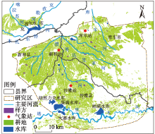
Fig. 1
Overview of the study area"
Tab. 1
List of the data used in this study"
| 名称 | 空间分 辨率/m | 波段 数量 | 成像时间(年-月-日) | 影像 数量 |
|---|---|---|---|---|
| Landsat_8 | 30 | 13 | 2013-06-23、2014-07-08 2015-07-15、2016-07-17 2017-07-04、2018-07-23 2019-07-26、2019-04-05 2020-05-25、2020-06-26 2020-07-28、2020-08-29 2020-09-14、2020-10-16 | 14 |
| Landsat_5 | 30 | 13 | 2008-05-08、2008-06-09 2009-04-25、2009-07-14 2010-08-31、2009-09-31 2009-10-18、2010-07-17 2011-07-04 | 9 |
| Landsat_7 | 30 | 11 | 2012-05-11、2012-07-14 | 2 |
Fig. 2
Statistics on cotton yield from 2009 to 2020"
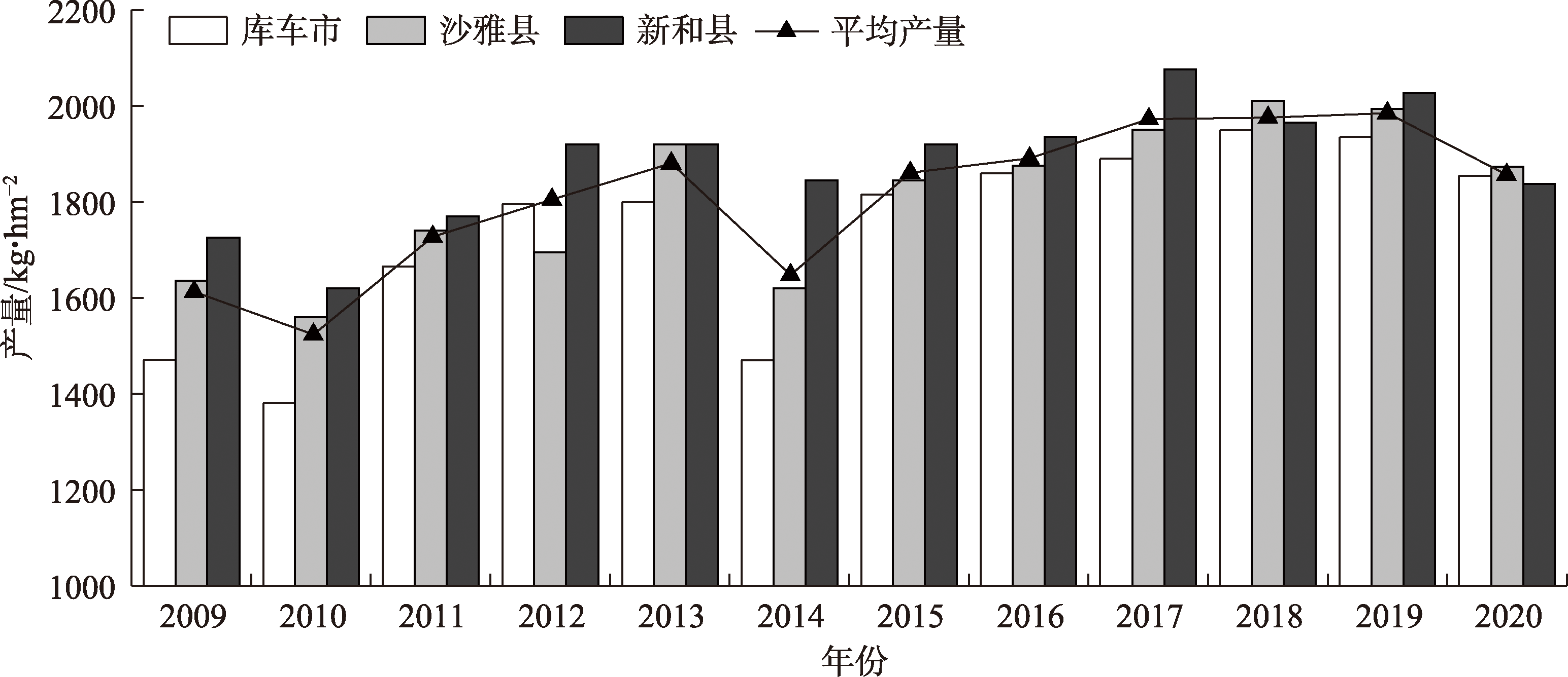
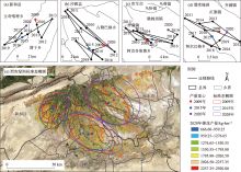
Fig. 3
Standard deviation ellipse and gravity movement of cotton yield"

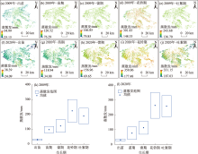
Fig. 4
Evapotranspiration during cotton growing"

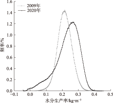
Fig. 5
Frequency distribution of water productivity in 2009 and 2020"

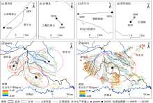
Fig. 6
Spatial distribution and gravity movement of cotton water productivity"

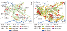
Fig. 7
LISA aggregation diagram of water productivity"

| [1] | 新华网. 新疆棉花产量占全国90.2%创历史新高[EB/OL]. http://www.news.cn/local/2022-12/27/c_1129236779.htm. 2022-12-27. |
| [Xinhua Net. Xinjiang’s cotton production accounts for 90.2% of the country’s total, a record high[EB/OL]. http://www.news.cn/local/2022-12/27/c_1129236779.htm. 2022-12-27. ] | |
| [2] |
胡栩, 聂勇, 徐霞, 等. 塔里木盆地南缘和田地区土地利用变化的遥感研究[J]. 地理科学进展, 2020, 39(4): 577-590.
doi: 10.18306/dlkxjz.2020.04.005 |
|
[Hu Xu, Nie Yong, Xu Xia, et al. Monitoring land-use change in Hetian Tarim Basin, China using satellite remote sensing observation between 1990 and 2016[J]. Progress in Geography, 2020, 39(4): 577-590. ]
doi: 10.18306/dlkxjz.2020.04.005 |
|
| [3] |
张沛, 龙爱华, 海洋, 等. 1988—2015年新疆农业用水时空变化与政策驱动研究——基于农作物水足迹的统计分析[J]. 冰川冻土, 2021, 43(1): 242-253.
doi: 10.7522/j.issn.1000-0240.2018.1058 |
|
[Zang Pei, Long Aihua, Hai Yang, et al. Spatiotemporal variations and driving forces of agricultural water consumption in Xinjiang during 1988—2015: Based on statistical analysis of crop water footprint[J]. Journal of Glaciology and Geocryology, 2021, 43(1): 242-253. ]
doi: 10.7522/j.issn.1000-0240.2018.1058 |
|
| [4] | 崔远来, 熊佳. 灌溉水利用效率指标研究进展[J]. 水科学进展, 2009, 20(4): 590-598. |
| [Cui Yuanlai, Xiong Jia. Advances in assessment indicators of irrigation water use efficiency[J]. Advances in Water Science, 2009, 20(4): 590-598. ] | |
| [5] |
陈仲新, 郝鹏宇, 刘佳, 等. 农业遥感卫星发展现状及我国监测需求分析[J]. 智慧农业, 2019, 1(1): 32-42.
doi: 10.12133/j.smartag.2019.1.1.201901-SA003 |
|
[Chen Zhongxin, Hao Pengyu, Liu Jia. et al. Technical demands for agricultural remote sensing satellites in China[J]. Smart Agriculture, 2019, 1(1): 32-42. ]
doi: 10.12133/j.smartag.2019.1.1.201901-SA003 |
|
| [6] | 周柳萍. 基于遥感和气象数据的江苏省水稻水分生产率时空变化研究[D]. 杭州: 浙江大学, 2015. |
| [Zhou Liuping. Study on temporal and spatial variation of rice water productivity of Jiangsu Province based on remote sensing and meteorological data[D]. Hangzhou: Zhejiang University, 2015. ] | |
| [7] | 蒋磊, 杨雨亭, 尚松浩. 基于遥感蒸发模型的干旱区灌区灌溉效率评价[J]. 农业工程学报, 2013, 29(20): 95-101. |
| [Jiang Lei, Yang Yuting, Shang Songhao. Evaluation on irrigation efficiency of irrigation district in arid region based on evapotranspiration estimated from remote sensing data[J]. Transactions of the Chinese Society of Agricultural Engineering, 2013, 29(20): 95-101. ] | |
| [8] | 杨建莹. 基于SEBAL模型的黄淮海冬小麦和夏玉米水分生产力研究[D]. 北京: 中国农业科学院, 2014. |
| [Yang Jianying. Study on water productivity of winter wheat and summer maize based on SEBAL model in Huang-Huai-Hai Plain, China[D]. Beijing: Chinese Academy of Agricultural Sciences, 2014. ] | |
| [9] |
Waldhoff G, Lussem U, Bareth G. Multi-data approach for remote sensing-based regional crop rotation mapping: A case study for the Rur catchment, Germany[J]. International Journal of Applied Earth Observation and Geoinformation, 2017, 61: 55-69.
doi: 10.1016/j.jag.2017.04.009 |
| [10] | Zhou Q, Zhang Y L, Wu F. Evaluation of the most proper management scale on water use efficiency and water productivity: A case study of the Heihe River Basin, China[J]. Agricultural Water Management, 2021, 246: 106671, doi: org/10.1016/j.agwat.2020.106671. |
| [11] |
Ghorbanpour A K, Kisekka I, Afshar A, et al. Crop water productivity mapping and benchmarking using remote sensing and Google Earth Engine cloud computing[J]. Remote Sensing, 2022, 14(19): 4934-4934.
doi: 10.3390/rs14194934 |
| [12] | Mauget S, Ulloa M, Mitchell-McCallister D. Simulated irrigation water productivity and related profit effects in US Southern High Plains cotton production[J]. Agricultural Water Management, 2022, 266: 107582, doi: 10.1016/j.agwat.2022.107582. |
| [13] | Chen X P, Qi Z M, Gui D W, et al. Evaluation of a new irrigation decision support system in improving cotton yield and water productivity in an arid climate[J]. Agricultural Water Management, 2020, 234: 106139, doi: 10.1016/j.agwat.2020.106139. |
| [14] | Thorp K R, Thompson A L, Bronson K F. Irrigation rate and timing effects on Arizona cotton yield, water productivity, and fiber quality[J]. Agricultural Water Management, 2020, 234: 106146, doi:10.1016/j.agwat.2020.106146. |
| [15] | Himanshu S K, Fan Y, Ale S, et al. Simulated efficient growth-stage-based deficit irrigation strategies for maximizing cotton yield, crop water productivity and net returns[J]. Agricultural Water Management, 2021, 250: 106840, doi: 10.1016/j.agwat.2021.106840. |
| [16] | 柯映明. 近60年来渭干河流域耕地与胡杨的时空演变分析[D]. 北京: 中国科学院, 2020. |
| [Ke Yingming. Spatiotemporal evolution analysis of cropland and Populus euphratica in Weigan River Basin in recent 60 years[D]. Beijing: University of Chinese Academy of Sciences, 2020. ] | |
| [17] | 张新焕, 杨德刚, 刘云同. 基于能值的绿洲种植业系统可持续性及敏感性评价——以新疆渭干河流域为例[J]. 生态学报, 2009, 29(11): 6068-6076. |
| [Zhang Xinhuan, Yang Degang, Liu Yuntong. Emergy-based sustainability and sensitivity analysis of oasis cropping system: A case study in Weigan River Basin[J]. Acta Ecologica Sinica, 2009, 29(11): 6068-6076. ] | |
| [18] | Paul M, Rajib A, Negahban-Azar M, et al. Improved agricultural water management in data-scarce semi-arid watersheds: Value of integrating remotely sensed leaf area index in hydrological modeling[J]. Science of the Total Environment, 2021, 791: 148177, doi: 10.1016/j.scitotenv.2021.148177. |
| [19] |
赵文亮, 贺振, 贺俊平, 等. 基于MODIS-NDVI的河南省冬小麦产量遥感估测[J]. 地理研究, 2012, 31(12): 2310-2320.
doi: 10.11821/yj2012120018 |
|
[Zhao Wenliang, He Zhen, He Junping, et al. Remote sensing estimation for winter wheat yield in Henan based on the MODIS-NDVI data[J]. Geographical Research, 2012, 31(12): 2310-2320. ]
doi: 10.11821/yj2012120018 |
|
| [20] | 王文静, 张霞, 赵银娣, 等. 综合多特征的Landsat 8时序遥感图像棉花分类方法[J]. 遥感学报, 2017, 21(1): 115-124. |
| [Wang Wenjing, Zhang Xia, Zhao Yindi, et al. Cotton extraction method of integrated multi-features based on multi-temporal Landsat 8 images[J]. Journal of Remote Sensing, 2017, 21(1): 115-124. ] | |
| [21] | 田艳君, 石莹, 帅艳民, 等. 基于遥感时序特征的地表覆被信息提取[J]. 干旱区地理, 2021, 44(2): 450-459. |
| [Tian Yanjun, Shi Ying, Shuai Yanmin, et al. Land cover information retrieval from temporal features based remote sensing images[J]. Arid Land Geography, 2021, 44(2): 450-459. ] | |
| [22] | 刘雅婷, 龚龑, 段博, 等. 多时相NDVI与丰度综合分析的油菜无人机遥感长势监测[J]. 武汉大学学报(信息科学版), 2020, 45(2): 265-272. |
| [Liu Yating, Gong Yan, Duan Bo, et al. Combining multi-temporal NDVI and abundance from UAV remote sensing data for oilseed rape growth monitoring[J]. Geomatics and Information Science of Wuhan University, 2020, 45(2): 265-272. ] | |
| [23] | 刘焕军, 孟令华, 张新乐, 等. 基于时间序列Landsat影像的棉花估产模型[J]. 农业工程学报, 2015, 31(17): 215-220. |
| [Liu Huanjun, Meng Linghua, Zhang Xinle, et al. Estimation model of cotton yield with time series Landsat images[J]. Transactions of the Chinese Society of Agricultural Engineering, 2015, 31(17): 215-220. ] | |
| [24] | 高中灵, 徐新刚, 王纪华, 等. 基于时间序列NDVI相似性分析的棉花估产[J]. 农业工程学报, 2012, 28(2): 148-153. |
| [Gao Zhongling, Xu Xingang, Wang Jihua, et al. Cotton yield estimation based on similarity analysis of time-series NDVI[J]. Transactions of the Chinese Society of Agricultural Engineering, 2012, 28(2): 148-153. ] | |
| [25] |
Meng H L, Liu H J, Zhang X L, et al. Assessment of the effectiveness of spatiotemporal fusion of multi-source satellite images for cotton yield estimation[J]. Computers and Electronics in Agriculture, 2019, 162: 44-52.
doi: 10.1016/j.compag.2019.04.001 |
| [26] | 刘峻明, 周舟, 和晓彤, 等. 频率直方图与植被指数结合的冬小麦遥感产量估测[J]. 农业工程学报, 2021, 37(23): 145-152. |
| [Liu Junming, Zhou Zhou, He Xiaotong, et al. Estimating winter wheat yield under frequency histogram and vegetation index using remote sensing[J]. Transactions of the Chinese Society of Agricultural Engineering, 2021, 37(23): 145-152. ] | |
| [27] |
Cai X L, Sharma B R. Integrating remote sensing, census and weather data for an assessment of rice yield, water consumption and water productivity in the Indo-Gangetic River Basin[J]. Agricultural Water Management, 2010, 97(2): 309-316.
doi: 10.1016/j.agwat.2009.09.021 |
| [28] | Bastiaanssen W G M, Menenti M, Feddes R A, et al. A remote sensing surface energy balance algorithm for land (SEBAL). 1. Formulation[J]. Journal of Hydrology, 1998, 212-213: 198-212. |
| [29] | Bastiaanssen W G M, Ahmad M D, Chemin Y. Satellite surveillance of evaporative depletion across the Indus Basin[J]. Water Resources Research, 2002, 38(12): 9-1-9-9. |
| [30] | 黄青, 王利民, 滕飞. 利用MODIS-NDVI数据提取新疆棉花播种面积信息及长势监测方法研究[J]. 干旱地区农业研究, 2011, 29(2): 213-217. |
| [Huang Qing, Wang Limin, Teng Fei. MODIS-NDVI-based monitoring of cotton planting areas and growth condition in Xinjiang[J]. Agricultural Research in the Arid Areas, 2011, 29(2): 213-217. ] | |
| [31] |
马春玥, 买买提·沙吾提, 姚杰, 等. 1950—2015年中国棉花生产时空动态变化[J]. 地理学报, 2020, 75(8): 1699-1710.
doi: 10.11821/dlxb202008010 |
|
[Ma Chunyue, Sawut Mamat, Yao Jie, et al. Spatio-temporal changes of cotton production in China from 1950 to 2015[J]. Acta Geographica Sinice, 2020, 75(8): 1699-1710. ]
doi: 10.11821/dlxb202008010 |
|
| [32] | 杨欢, 邓帆, 张佳华, 等. 基于MODIS EVI的江汉平原油菜和冬小麦种植信息提取研究[J]. 国土资源遥感, 2020, 32(3): 208-215. |
| [Yang Huan, Deng Fan, Zhang Jiahua, et al. A study of information extraction of rape and winter wheat planting in Jianghan Plain based on MODIS EVI[J]. Remote Sensing for Land and Resources, 2020, 32(3): 208-215. ] | |
| [33] |
Xu C C, Zhang X C, Zhang J X, et al. Estimation of crop water requirement based on planting structure extraction from multi-temporal MODIS EVI[J]. Water Resources Management, 2021, 35: 2231-2247.
doi: 10.1007/s11269-021-02838-y |
| [34] | 于兵. 作物水分生产率及种植适宜度的遥感评价方法[D]. 北京: 清华大学, 2019. |
| [Yu Bing. Remote sensing based assessment method for crop water productivity and planting suitability[D]. Beijing: Tsinghua University, 2019. ] |
| [1] | LI Hongyang, CHEN Tianyu, WANG Shengjie, ZHANG Mingjun. Spatiotemporal variations of potential evapotranspiration on the northern slope of the Kunlun Mountains in Xinjiang from 1979 to 2021 [J]. Arid Land Geography, 2024, 47(9): 1443-1450. |
| [2] | LIU Yu, MEI Hua, FAN Wenbo, REN Congzhe, WANG Shiwei, LI Shunshun. Temporal and spatial characteristics of drought in the Ta’e Basin from 1992 to 2022 based on the SPEI index [J]. Arid Land Geography, 2024, 47(8): 1338-1347. |
| [3] | MA Yali, NIU Zuirong, SUN Dongyuan. Relationship between changes in spatial and temporal patterns of potential evapotranspiration and meteorological factors in the Hexi Corridor [J]. Arid Land Geography, 2024, 47(2): 192-202. |
| [4] | GAO Xiaoyu, HAO Haichao, ZHANG Xueqi, CHEN Yaning. Responses of vegetation water use efficiency to meteorological factors in arid areas of northwest China: A case of Xinjiang [J]. Arid Land Geography, 2023, 46(7): 1111-1120. |
| [5] | WEI Tao, WANG Yunquan. Temporal and spatial dynamic analysis of terrestrial evapotranspiration in China based on PML-V2 product [J]. Arid Land Geography, 2023, 46(6): 857-867. |
| [6] | YANG Yifei, YANG Pengnian, WANG Changshu, KOU Xin, TAN Fan, XU Jie, WANG Cui. Effectiveness evaluation of water consumption in agricultural land of Yanqi Basin, Xinjiang [J]. Arid Land Geography, 2023, 46(5): 730-741. |
| [7] | CAO Yujuan, SI Wenyang, DU Ziqiang, LIANG Hanxue, LEI Tianjie, SUN Bin, WU Zhitao. Changes in GPP of China during the typical drought years from 1982 to 2017 [J]. Arid Land Geography, 2023, 46(10): 1577-1590. |
| [8] | MEI Jing, SUN Meiping, LI Lin. Variations of evapotranspiration and its components in alpine meadow on the Tibetan Plateau based on SWH model [J]. Arid Land Geography, 2022, 45(6): 1740-1751. |
| [9] | FU Yinghao, SHEN Xiaojing, LI Wangcheng, WU Xu, ZHANG Qingqing. Applicability of reference crop evapotranspiration calculation based on Hargreaves-Samani regression correction [J]. Arid Land Geography, 2022, 45(6): 1752-1760. |
| [10] | HAN Rucun,ZHANG Ying,LI Zhanling. Effects of two uncertainty sources on drought index of SPEI and on drought assessment [J]. Arid Land Geography, 2022, 45(5): 1392-1401. |
| [11] | HAN Dianchen,ZHANG Fangmin,CHEN Jiquan,LI Yunpeng,LU Qi,LU Yanyu. Evapotranspiration of a semi-arid landscape in Inner Mongolia: Estimation and attribution [J]. Arid Land Geography, 2022, 45(4): 1071-1081. |
| [12] | PAN Zihao,YANG Shengtian,LOU Hezhen,YU Jingjie,WANG Zhongjing,ZHANG Jun. Remote sensing monitoring of ecological water conveyance and benefits evaluation of agricultural water-saving in arid basin without observation station [J]. Arid Land Geography, 2022, 45(3): 774-785. |
| [13] | SHI Jiqing,BIAN Duo,YANG Feiyun,GAN Chenlong,FAN Dongliang. Variation characteristics of potential evapotranspiration and the forecast of grey model in Tibet [J]. Arid Land Geography, 2021, 44(6): 1570-1579. |
| [14] | GU Jiahe,XUE Huazhu,DONG Guotao,ZHOU Lijuan,LI Jingru,DANG Suzhen,LI Shangzhi. Effects of NDVI/land-use on spatiotemporal changes of evapotranspiration in the Yellow River Basin [J]. Arid Land Geography, 2021, 44(1): 158-167. |
| [15] | NING Ya-zhou, ZHANG Fu-ping, FENG Qi, WEI Yong-fen, LI Ling, LIU Jie-yao, ZENG Pan-ru. Estimation of evapotranspiration in Shule River Basin based on SEBAL model and evaluation on irrigation efficiency [J]. Arid Land Geography, 2020, 43(4): 928-938. |
| Viewed | ||||||||||||||||||||||||||||||||||||||||||||||||||
|
Full text 65
|
|
|||||||||||||||||||||||||||||||||||||||||||||||||
|
Abstract 259
|
|
|||||||||||||||||||||||||||||||||||||||||||||||||
Cited |
|
|||||||||||||||||||||||||||||||||||||||||||||||||
| Shared | ||||||||||||||||||||||||||||||||||||||||||||||||||
|
||